Crewkerne Risk Profile 2018/19 - Devon & Somerset Fire & Rescue ...
←
→
Page content transcription
If your browser does not render page correctly, please read the page content below
Crewkerne Risk Profile 2018/19
Crewkerne Risk Profile 2018/19 2
Overview
appliance and an off road vehicle (L4V), with the Below are the Officers in charge at this station.
capability to transport a mobile water pump. The
Station is crewed by on call staff working a
retained duty system of 12 personnel – one
Watch Manager, two Crew Managers and eleven
fire fighters. The staff are also instrumental in
identifying the community safety activities
required to prevent fires, deaths and injuries in Watch Manager Crew Manager
fires. Crewkerne fire station is a proud partner Mike Page Dean Peaty
with “Friends of Crewkerne hospital” and
Crewkerne Rotary club who have raised
charitable funds to provide a network of public
access Deliberators in Crewkerne.
This plan presents the risks in your area and The station area is home to a range of risks,
the actions that Devon & Somerset Fire & including several residential care homes, major T/Crew Manager T/Crew Manager
Rescue Service (DSFRS) will take to make the ‘A’ roads into and out of the town, and the main Photo unavailable Mark Pearce
community safer. Our actions are a mix of rail link between London and the South West of
activities based on prevention, protection and England. Other risks include a retail and
emergency response, all undertaken by the industrial park. The local Authority areas served
people that are best suited for each activity. are Somerset County Council & South Somerset
District Council. Outside of the town, the
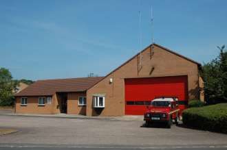
Crewkerne Fire Station is located on the Blacknell
fireground also covers an extensive area of open
Lane Trading Estate in Crewkerne, and covers the
fields, agricultural properties, thatched roof To discuss the content of this plan with a
town of Crewkerne and surrounding communities
properties and woodland areas, which member of the fire service, please use the
and part of Somerset County Council. It covers an
themselves can cause significant risks. contact details below:
area of 65.76 square kilometres and a population
of 11,536 people. There are 8000 domestic and Name: Somerset East Admin Office
The area has a mixture of light industry and
commercial properties. The station covers the commerce, and major employers include Sterling Tel: 01935 382000
Crewkerne, Eggwood & Parrett council wards. Hydraulics and Coombe Farm. It also includes a Email: adminyeovilwells@dsfire.gov.uk
large rural area.
The Watch Manager has overall responsibility for For more information please visit
the station. The fire station houses one firefighting www.dsfire.gov.uk/yoursafety
www.dsfire.gov.uk V1.0 Published April 2018Crewkerne Risk Profile 2018/19 3
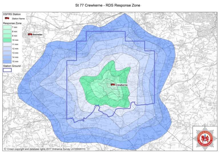
Our Response
The map opposite shows an estimate of
how long the fire engine will take to
reach residents in Crewkerne from the
time they make the call. It will naturally
take us longer to get places further
away from the station.
Residents of Crewkerne should take the
following precautions to help keep them
safe from fire:
Fit a working smoke alarm
Take care when cooking and
never leave cooking food
unattended
Plan and practise your escape
route
Make a bedtime check
Don't overload your electrics
Put cigarettes right out
Use candles carefully
Have your chimney swept
regularly
www.dsfire.gov.uk V1.0 Published April 2018Crewkerne Risk Profile 2018/19 4
Prevention and Protection
We maintain a very simple philosophy that prevention is better than cure and we recognise that risk reduction begins with safe behaviours at home, at
work, or on the road, and this leads to a safer society for all. We have developed a community safety strategy to focus our work and set our levels of
resourcing where we have most risk. Using our knowledge, along with that of local organisations and partners we will target those people and
properties that are more likely to be affected by fire and other emergencies, according to our risk analysis and risk profiling. The risks identified at
Crewkerne station have been identified below, our prevention and protection work will be prioritised accordingly.
Youth
Health
Dwelling Business Road Community Water Development
& Heritage
Fires Safety Safety Resilience Safety & Community
Wellbeing
Cohesion
Risk Key
VERY HIGH HIGH MEDIUM LOW VERY LOW
www.dsfire.gov.uk V1.0 Published April 2018Crewkerne Risk Profile 2018/19 5
Our Incidents
The activity information for this local community area is shown in the tables below.
Incidents attended (within station area)
Five Year
Station - 77 Crewkerne 2012/13 2013/14 2014/15 2015/16 2016/17
Average
All Fires 29 35 33 30 20 29
Fires where people live (primary) 4 6 8 4 5 5
Fires where people work and visit (primary) 10 15 13 13 7 12
Fires - outdoor and refuse fires (secondary) 6 10 7 9 8 8
Chimney Fires 9 4 5 4 0 4
All False Alarms 36 37 25 29 50 35
False Alarms - Automatic Fire Alarms 19 21 16 25 40 24
False Alarms - Good Intent 17 14 9 4 10 11
False Alarms - Malicious attended 0 2 0 0 0 0
All Special Service Calls 26 29 25 37 22 28
Co-Responding 1 0 1 0 0 0
Road Traffic Collisions 10 14 13 19 10 13
Flooding & Water Rescues 8 5 1 9 0 5
Other Special Service calls 7 10 10 9 12 10
All Incidents 91 101 83 96 92 93
All Incidents minus False alarms 55 64 58 67 42 57
All Incidents minus False alarms and Co-Res. 54 64 57 67 42 57
Station Availability
In the 12 months from April 2016 to March 2017 the station was able to
crew the following appliances
% Hours
Hours Unavailable
Availability
Fire Engine 1 Retained 39.75 99.5%
www.dsfire.gov.uk V1.0 Published April 2018Crewkerne Risk Profile 2018/19 6
Station Response Activity:
The table below shows the number of times the local fire station was called out (which may or may not have resulted in attending an incident). It also shows the
number percentage of calls on and off the station ground.
5 year
Station - 77 Crewkerne 2012/13 2013/14 2014/15 2015/16 2016/17
average
Total Turnouts 126 154 116 143 154 139
Turnouts to incidents on Station Ground 84 102 84 94 96 92
% of Turnouts to Incidents on Station Ground 66.7% 66.2% 72.4% 65.7% 62.3% 66.4%
% of Turnouts to incidents not on Station Ground 33.3% 33.8% 27.6% 34.3% 37.7% 33.6%
Station Demand 2012/13 - 2016/17
The graphs below demonstrate the peak demand on the station in terms of time of the day and month of the year. (*Incidents in station area, not including false
alarms or co-responding)
Hour of the day Month of the year
12 14
Annual Number of Incidents
Annual Number of Incidents
10 12
10
8
8
6
6
4
4
2 2
0 0
0 1 2 3 4 5 6 7 8 9 10 11 12 13 14 15 16 17 18 19 20 21 22 23 Jan Feb Mar Apr May Jun Jul Aug Sep Oct Nov Dec
Hour of Day Month of Year
5 yr Average - Stn 77 2016/17 - Stn 77 5 yr Average - Stn 77 2016/17 - Stn 77
www.dsfire.gov.uk V1.0 Published April 2018You can also read