Workshop report - EuroSDR
←
→
Page content transcription
If your browser does not render page correctly, please read the page content below
Identifying common interests and future research issues in
  the field of crowd sourcing for the updating of national
                        databases

                 Workshop report

                     Workshop organized by
                     EuroSDR
                     and
                     Swiss Federal Office of Topography

                     Thursday / Friday August 20-21, 2009
                     Federal Office of Topography, swisstopo
                     Wabern, Switzerland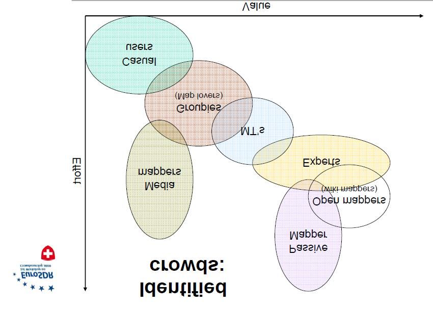
Workshop Report: Crowd Sourcing for the Updating of
National Databases
This document is the report of the 1st EuroSDR Workshop on Crowd Sourcing for the
Updating of National Databases, held at the Federal Office of Topography
(swisstopo), Wabern, Switzerland on 20-21 August 2009.

swisstopo ket - 28/08/2009
Crowdsourcing Workshop Report V 1.0                                    Page 2 of 16
Workshop Information
Title:         1st EuroSDR Workshop on Crowd Sourcing for Updating National
               Databases
Date:          Thursday 20th and Friday 21st August 2009
Venue:         Swiss Federal Office of Topography (swisstopo), Wabern, Switzerland

Goals
The workshop, organized by EuroSDR and the Swiss Federal Office of Topography
swisstopo, dealt with the use of Web 2.0 technologies and communities for the
mutual use of user generated content in the framework of national databases.
Current applications and data management processes were reviewed and
experiences and expectations, as well as current limitations and challenges,
discussed.

Topics

    ·    Web 2.0 technologies and communities
    ·    User acceptance
    ·    Data management
    ·    Quality issues
    ·    Legal tasks
    ·    Advantages and Challenges for National Mapping and Cadastral Agencies

On day one of the workshop participants from the private sector, universities and
government gave presentations on current projects and the state of the art. On day
two common themes and future research needs were explored.

Workshop homepage
Information and further details can be obtained from the workshop homepage at
http://www.swisstopo.ch/ and
http://www.eurosdr.net/workshops/crowdsourcing_2009/index.htm

swisstopo ket - 28/08/2009
Crowdsourcing Workshop Report V 1.0                                      Page 3 of 16
Report
The Workshop was held at the Swiss Federal Office of Topography (swisstopo),
Wabern, Switzerland, Thursday 20th and Friday 21st August 2009.

    ·   Welcome and Introduction
    ·   Presentations I
    ·   Presentations II
    ·   Summary of day one
    ·   Break-out sessions and presentations
    ·   Conclusions
    ·   Next steps

Introduction

39 delegates from the United Kingdom, Sweden, Belgium, Germany, The
Netherlands, Spain, France and Switzerland attended the Workshop "Crowd
Sourcing for Updating National Databases" on 20-21 August 2009 in Wabern,
Switzerland. The Workshop was organized by EuroSDR Commission III and the
Swiss Federal Office of Topography (swisstopo).

The Workshop was opened by André Streilein, Chair of EuroSDR Commission III,
who welcomed the delegates to the Swiss Federal Office of Topography (swisstopo).
He high-lighted the motivation and goals of this first workshop by identifying common
interests and future research issues in the field of crowd sourcing for updating
national databases. The use of Web 2.0 technologies and communities for the
mutual use of user generated content in the framework of national databases is
definitively an issue of importance for all national mapping agencies and map
providers.

Presentations I

The first session of presentation was opened by Jantien Stoter from ITC Enschede,
TU Delft and Kadaster, The Netherlands, with a presentation entitled "Crowd
sourcing for updating national databases in The Netherlands". She illustrated the
present crowd sourcing activities in The Netherlands by three examples. The
introduction of Web 2.0 technologies by the Netherland’s Kadaster and the
Municipality of Rotterdam is currently under discussion but is hampered mainly by
fears regarding quality, reliability and licensing issues. However in the provinces
some Web 2.0 like applications help to gather specific geo-located information, for
instance, for bird counting or damage reporting. The main problems are identified as
reliability and commercial licensing.

swisstopo ket - 28/08/2009
Crowdsourcing Workshop Report V 1.0                                        Page 4 of 16
Malcom Havercroft, Head of Operations from Ordnance Survey Great Britain, presented in his talk "Crowd-sourcing – some experiences and thoughts", recent research and projects in Great Britain. First, he described crowd sourcing applications in the broadest sense, where vernacular geographical place names are harvested in the web. He then focused on the Ordnance Survey "Explore" portal, where the outdoor community can contribute with, and ask for, hiking routes in the UK (http://explore.ordnancesurvey.co.uk/). The presentation was summarized with a graph, showing the main interacting/dependant variables of a crowdsourcing process: data volume, sourced data value, solution technology, economic aspects and level of accreditation system. Malcom Havercroft identified the main tasks to proceed as identifying the crowd, specification of the data looked for, accreditation aspects, technology and business model. Geotagged photos in Web 2.0 sharing sites was the topic of the talk of Vyron Antoniou, University College of London, UK, "Do photo sharing websites represent a sufficient database to aid in national map updating or change detection?". In his PhD work he assessed the spatial dimension of the geotagged photos phenomenon in the UK by examining the popular Web 2.0, photo-sharing websites of Flickr, Panoramio, Picasa Web and Geograph. He suggested that such Web sources can be categorized into spatially implicit and spatially explicit ones. Spatially explicit applications urge their users to interact directly with spatial features while at the same time encourage the content to be distributed. In contrast spatially implicit Web applications are more social-oriented and do not focus on the spatial element. He showed, that the covered area is as expected dominated by tourist sites and has, on a countrywide perspective, gaps. Spatially implicit applications such as Flickr, Picasa Web and Panoramio end up with a huge amount of data but poor spatial coverage whereas spatially explicit sources such as Geograph provide acceptable coverage with moderate data volumes. Jean-Christophe Guélat, swisstopo, Switzerland, presented in his talk "Integration of user generated content into national databases" the actual and planned revision workflow web tool of the Swiss Federal Office of Topography. The present revision workflow is a one way approach from revision notifications of users, analysed by a centralised revision dispatcher and distributed to the different production processes of swisstopo. The future developments will include vector and GPS attachments and an exchange with, and accreditation of, the data user. Presentations II The second session started with the presentation of the OpenAdresses project by Hans-Jörg Stark, University of Applied Sciences Northwestern Switzerland "An OpenGeodata Project: OpenAddresses". OpenAdresses (www.openaddresses.ch) is a project to collect geo-located addresses and linked attributes within a web interface by crowdsourcing. The project started in north-western Switzerland but has already expanded to some sites in Austria. Official geo-located address datasets already exist in Switzerland, but it is expensive and difficult to access. Crowdsourced or user generated datasets are free for the community and may be tailored to specific users needs. swisstopo ket - 28/08/2009 Crowdsourcing Workshop Report V 1.0 Page 5 of 16
Ross Purves, University of Zürich, Switzerland tackled in his talk about "Using crowd
sourcing to explore the semantics of place" the paradigm between the crisp, well
defined location of places in official datasets (e.g. addresses, districts, borders, etc.)
and the sometimes fuzzy or vague human perspectives of "places". His research on
exploring how people describe place is methodologically based on the analysis of
tagged, geo-located information in databases. This approach is probably not
"crowdsourcing" in the narrow sense, but does rely on user generated data.

François Golay, EPFL, Switzerland, pointed out some aspects of "The Cognitive
and Social Stakes of Crowd Sourcing". First he presented a short typology of data
collaboration dynamics from coexistence to fusion. A typology of data production
approaches may be separated into "traditional production", "autoproduction",
"crowdsourcing" and "coproduction". Each of the approaches has his own difficulties
and advantages. With a focus on crowdsourcing, Golay further discussed aspects of
the socio-cognitive appropriation mechanisms of collaborative data production and
pointed out the consequences for practice.

Jean-Marc Viglino, IGN, France "Handling partner’s feedbacks through the web"
explained the needs of IGN France for a partnership with institutional partners and
the public for updating geo-datasets in time and with low costs. The Ripart ("site de
remontée d’information partagée") feedback website of IGN (ripart.ign.fr) is one
element of their programme for collecting user generated content. Viglino outlined
some further aspects of the motivation and expectations of contributing crowds.

Nicolas Schmidt, a PhD student of HSR, Switzerland "QA of Crowdsourced
Geographic Content" presented working ideas and had some questions to the
audience in his talk. He highlighted the trust and quality aspects of some
crowdsourcing methods.

Summary of day one
In his summary , André Streilein expressed his thanks to the contributing participants
for giving such an insight and overview of the aspects of crowdsourcing. The
presentations had shown, that national mapping agencies have a distinct need to
include user generated information into their update process of their GIS data sets
and maps. An active scientific community exists in this field. Some research is in
progress but the coordination and focus needs to be strengthened.
A consultative poll revealed the interest of the audience in two main topics for the
next day break-out sessions. A first group wanted to discuss interaction aspects with
the crowd, whereas a second group was interested more in quality aspects.

swisstopo ket - 28/08/2009
Crowdsourcing Workshop Report V 1.0                                            Page 6 of 16
Break-out sessions and presentations
After the summary of day one, the participants had discussions in break-out groups
on the selected topics: "Interacting with the crowd", "Stakes of user generated
contents (UGC) and quality management" and "Quality aspects of crowdsourcing".
The moderated discussions in the groups were intensive and gave the participants
an opportunity to bring in personal experiences, questions and conclusions.
Afterwards the outcomes of the break-out sessions were presented by the
moderators and discussed in the plenum.
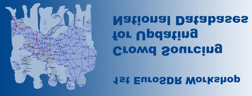
Group 1
Break-out group one (moderator Christian Heipke, University of Hannover Germany),
discussed different aspects of "Interacting with the crowd". The group agreed that it
is a fact that there is a lot of information out in the crowds, which is worth looking at
and potentially harvesting. How to identify fruitful crowds for mapping agencies and
how to interact raise open questions which need more clarification and even
definition. First the term "crowd sourcing" is understood as interaction with the
community and not as a data mining approach on the web. The Web 2.0 is, in
addition, not equal to crowd sourcing. Break-out group one identified several types of
(mapping) crowds according to the effort they spend for collecting data and to the
potential value (see Fig. 1).
Fig. 1. Identified crowds as proposed by break-out group one (Moderator C. Heipke)
The identified crowds for
· The "groupies": These are small groups of map (or any geodata)
lovers which produce trustable and very valuable data of great value.
The motivation is given by the public or the community specific
acknowledgment and recognition. It is a key issue to get the groupies
organized in community forums.
· The "casual users": Casual users are often identified as hikers, bikers,
mountaineers etc. This group partly overlaps with the groupies but are
swisstopo ket - 28/08/2009
Crowdsourcing Workshop Report V 1.0 Page 7 of 16distinguished by a lesser effort and therefore less valuable data
production. They contribute occasionally. Moderated community
platforms are necessary to group the casual users in communities of
critical mass.
· The "experts": Experts are active people and leading map experts in
organisations like mountain rescue, fire brigades, civil protection, traffic
guides, etc. They are motivated by the feeling that they may make their
own life easier, they can contribute with very valuable and trustable
information. But the experts have to be identified by, and committed to,
the mapping agencies with (financial) agreements.
· The "media mappers": Media mappers are potentially large groups,
activated sporadically by regional up to international media campaigns
(television, radio, internet forums, print media, etc.). These are mostly
once-off mappers specially motivated by competitions, mapping parties,
etc. The contributions are limited in time and extent and a big initial
effort for initiation of campaigns is needed. Over the long-term it would
be advisable for the mapping agencies to work to migrate the "media
mappers" to "casual mappers" or even "groupies".
· The "open mappers": The open mappers are small groups which
spend a lot of time to contribute very valuable and large information to
open source data sets or data systems (OpenStreetMap, MapShare,
Google MapMaker, etc.). They are motivated by contributing (and
using) good public data. The enhancement and simplification of the
associated Open Source mapping tools will help to grow the "open
mappers" groups.
· The "passive mappers": Mobile phones which incorporate GPS
positioning are a prime example of the new technologies that enable
the passive collection of information about position, time and speed of
individuals. The use of this information is restricted by law and / or
acceptance of the individuals. The utilisation of such resources for
mapping agencies is unclear and needs interpretation and intersection
with existing data sets. The potential crowd is certainly very large. In
specific cases an overlap to open mappers exists (for example mapped
waypoints of GPS devices).
· The "mechanical turks": The Amazon Mechanical Turk is a crowd
sourcing marketplace and service where human beings can contribute
to posed tasks for a monetary payment. The motivation of this medium
sized group is money. They can be used to gather needed data for
mapping agencies, but the delivered data would need careful checking.
Identification of the ideal crowds is one matter. However, to achieve a fruitful
interaction with the crowds opens up further research questions on a technological
and social level. Further research on quality issues such as completeness, trust,
interpretability etc. of crowd sourced data as well as on data integration is needed.
swisstopo ket - 28/08/2009
Crowdsourcing Workshop Report V 1.0 Page 8 of 16Group 2
The second break-out group, moderated by F. Golay, EPFL Switzerland, was
discussing the main "Stakes of user generated contents (UGC) and quality
management". They came up with a flowchart of the mapping agency to crowd
interactions (Fig. 2). The need to offer an optimised data model to the crowd, a better
internal workflow adaptation to included crowd sourced data and shorter
consolidation and updating time intervals were identified as elements of high priority
on the side of the mapping agencies. Involvement of excellent crowd members
(super-users), effective tools and interfaces and finding the trade-off between
prescribed (top-down) and emerging (bottom-up) data models improves the quality
and added value of user generated contents. Fostering synergies between the
mapping agencies and the crowd or other communities like OpenStreetMap help to
build trust in the data in the crowds and in the interactions. Open communication and
discussions of legal aspects helps to find acceptable agreements between the
crowds and the mapping agencies.
Fig. 2. Sketched summary of main stakes of user generated contents (UGC) and quality
management
Group 3
The third break-out group, moderated by Mike Jackson, Centre for Geospatial
Science, University of Nottingham, UK, focussed on the "quality aspects of crowd
sourcing". Quality is seen as "fitness for purpose". Quality of crowd sourced data
has multiple dimensions such as absolute and relative geometric accuracy, up-to-
dateness or currency, topological correctness, the accuracy of the metadata, the
legal aspects and the validation stamp by the officials (in case of national mapping
agencies). The assessment of quality also needs to address the more fuzzy spatial
concepts such as expressions like "the midlands", "the north", etc. The perceived
quality of crowd sourced data is not solely a matter of the measurement of physical
parameters.. Trusting in data is an additional dimension. Trusting in data is also
swisstopo ket - 28/08/2009
Crowdsourcing Workshop Report V 1.0 Page 9 of 16influenced by marketing elements, brand, origin ("national mapping agencies are
reliable"), type of information (‘we always trust in photos’).
Measuring the quality of crowd sourced data is context dependent – it ideally requires
a knowledge of the intended purpose that it is to be used for and the market needs.
A changing market may drive the need for different quality levels:
· Low cost crowd sourced location data for specific "high-usage" areas where
relative rather than absolute position is important but which also incorporates
rich complementary information (metadata) which is frequently (even
constantly) up-dated and validated (by officials such as mapping agencies).
Expensive data for a seamless coverage of an entire country.
The Break-out group suggested that national mapping agencies should follow such a
direction of dual databases, well linked, which may converge in the future. The
development and growth will certainly raise awareness of the usability of the data
and therefore enable trust to be a developed in the context of usage.
Conclusions
The findings of the three break-out groups were discussed in plenary in a spirited and
constructive discussion. André Streilein summarised the expressed needs for a
strong collaboration of the mapping agencies and the research communities in the
field of user generated content, which is identified as an important and valuable input
in map or geodata updating procedures, content generation and interaction with the
users. There is a lack on experiences, knowledge on interaction schemes, on
techniques, on legal aspects, on production process integration aspects. etc. The
dialogue between crowds and mapping agencies is in most cases not established or
on a very basic level. How to establish, support and motivate a community to achieve
tailored user generated content is seen as one main field of investigation.
The audience agreed, that research, exchange of facts and figures as well as further
workshops on crowd sourcing for national mapping agencies would be welcome and
even necessary.
swisstopo ket - 28/08/2009
Crowdsourcing Workshop Report V 1.0 Page 10 of 16Next steps
In order to pave the way for further activities on the topics of crowd sourcing, the
organising committee has subsequently asked the attendees of the workshop the
following questions by email:
1. Does your organisation have research and development projects, which are
finished, ongoing or planned, with respect to the issues of the workshop?
a. If yes, what are the topics of these projects?
2. Is your organisation willing to actively collaborate in a small group, which
investigates into the following topics:
a. How to collaborate with the crowd?
b. How to assure quality and reliability of the data collected?
swisstopo ket - 28/08/2009
Crowdsourcing Workshop Report V 1.0 Page 11 of 16Programme
Thursday, 20th August 2009 Friday, 21st August 2009
13:30 Welcome 8:30 Introduction to the break-out
13:40 Presentations (Part I) sessions
15:00 Coffee Break 8:40 Break-out session I, II and III
15:30 Presentations (Part II) 10:00 Coffee Break
16.50 Summary of the day 10:30 Plenary presentations of
17:20 End break-out sessions I - III
19:45 Dinner & discussion
11:30 Conclusion from the workshop
sessions and future steps
12:00 End of Meeting
Presentations (Part I) Thursday, 20th August 2009
13:40 Web 2.0 technologies and Dutch J. Stoter, ITC Enschede
Cadastre
14:00 Some OS experiences of crowd- M. Havercroft, OS UK
sourcing and some questions?
14:20 Do photo sharing websites V. Antoniou, University College London
represent a sufficient database to
aid in national map updating or
change detection?
14:40 Integration of user generated J.-Chr. Guélat, swisstopo, CH
content into national databases
Presentations (Part II) Thursday, 20th August 2009
15:30 OpenAddresses.ch - An H.-J. Stark, University of Applied Sciences NW
OpenGeodata project Switzerland
15:50 Using crowd sourcing to explore R. Purves, University of Zurich, CH
the semantics of place
16:10 The cognitive and social stakes of F. Golay / M. Noucher, EPFL Lausanne, CH
crowd sourcing
16:30 Project "Echange" and the J.-M. Viglino, IGN France
mapshare portal RIPart of IGN
France
16:50 QA of Crowdsourced Geographic N. Schmidt, Univ. of appl. Techn. Sciences,
Content Rapperswil, CH
swisstopo ket - 28/08/2009
Crowdsourcing Workshop Report V 1.0 Page 12 of 16Break-out sessions Friday, 21st August 2009
Session 1 Interacting with the crowd Moderated by: Ch. Heipke, University of
Hannover, D
Session 2 Quality aspects of CS (group 1) Moderated by: F. Golay, EPFL, CH
Session 3 Quality aspects of CS (group 2) Moderated by: M. Jackson, University of
Nottingham, UK
Hosting group
Federal Office of Topography - swisstopo
Seftigenstrasse 264
P.O. Box
3084 Wabern
info@swisstopo.ch
André Streilein, Jesko Schaper, Tobias Kellenberger, Thomas Koenig, Jean-
Christophe Guélat
The Federal Office of Topography (official name) is the Swiss National Mapping
Agency since 1838. Swisstopo has about 300 employees. In the function of the
Federal Geo-Information centre swisstopo produces high-quality spatial reference
data and products derived thereof. It coordinates the activities for federal basis
geodata and promotes their broad application. Swisstopo guarantees to provide data
and fundamental bases for a monitoring of the spatial development in Switzerland.
swisstopo ket - 28/08/2009
Crowdsourcing Workshop Report V 1.0 Page 13 of 16List of participants
Last name First Name Affiliation Country
Dept. Civil, Environmental & Geomatic Engineering,
Antoniou Vyron UK
University College London
Baumgartner Michael MFB-Geoconsulting CH
Buogo Alain Federal Office of Topography, swisstopo CH
Dräyer Relling Susanne Federal Office of Topography, swisstopo CH
Haute Ecole d'Ingénierie et de Gestion du Canton de
Ertz Olivier CH
Vaud (HEIG-VD)
Feurer Christine Federal Office of Topography, swisstopo CH
Coordination Web, Institut géographique national de la
Flandroit Dominique B
Belgique
Haute Ecole d'Ingénierie et de Gestion du Canton de
Freyre Jérôme CH
Vaud (HEIG-VD)
Gleerup Andrea Lantmäteriet, division Informationsförsörjning S
GIS Research Laboratory, Ecole polytechnique fédérale
Golay Francois CH
de Lausanne (EPFL)
Gschwend Christian Department of Geography, University of Zurich - Irchel CH
Guélat Jean-Christophe Federal Office of Topography, swisstopo CH
Havercroft Malcolm Data Collection & Management, Ordnance Survey UK UK
Heilig Markus Federal Office of Topography, swisstopo CH
Institute of Photogrammetry and GeoInformation, Leibniz
Heipke Christian D
University of Hannover
Centre for Geospatial Science, The University of
Jackson Mike UK
Nottingham
Käuferle Dominik Federal Office of Topography, swisstopo CH
swisstopo ket - 28/08/2009
Crowdsourcing Workshop Report V 1.0 Page 14 of 16Last name First Name Affiliation Country
Kellenberger Tobias Federal Office of Topography, swisstopo CH
Institut for Software, HSR Technical University of Applied
Keller Stefan F. CH
Sciences
Kjellström Bengt Lantmäteriet, division Informationsförsörjning S
Koenig Thomas Federal Office of Topography, swisstopo CH
Lanini Michael MFB-Geoconsulting CH
Lechner Marco Department of Physical Geography, University of Freiburg D
Coordination Web, Institut géographique national de la
Mouton Jean-Pierre B
Belgique
VITO - Flemish Institute for Technological Research, TAP
Nackaerts Kris - Centre for Remote Sensing and Earth Observation NL
Processes
Neun Moritz ESRI Switzerland AG CH
Oesterlin Nils Federal Office of Topography, swisstopo CH
O'Sullivan Liam Federal Office of Topography, swisstopo CH
Philipona Claude Camptocamp SA CH
Department of Topographic Databases, Institut
Pla Maria E
Cartogràfic de Catalunya
Purves Ross Department of Geography, University of Zurich - Irchel CH
Haute Ecole d'Ingénierie et de Gestion du Canton de
Rappo Daniel CH
Vaud (HEIG-VD)
Schaper Jesko Federal Office of Topography, swisstopo CH
Institut for Software, HSR Technical University of Applied
Schmidt Nicolas CH
Sciences
Schrotter Gerhard GIS Competence Centre, City of Zürich CH
swisstopo ket - 28/08/2009
Crowdsourcing Workshop Report V 1.0 Page 15 of 16Last name First Name Affiliation Country
Institute of Survey and Geoinformation, University of
Stark Hans-Jörg CH
Applied Sciences Northwestern Switzerland
Geo-information processing / ITC Enschede and Kadaster
Stoter Jantien NL
/ TU Delft
Streilein André Federal Office of Topography, swisstopo CH
Tomko Martin Department of Geography, University of Zurich - Irchel CH
Viglino Jean-Marc Project "Echanges", IGN-France F
swisstopo ket - 28/08/2009
Crowdsourcing Workshop Report V 1.0 Page 16 of 16You can also read