Data Management Plan - Hotmaps
←
→
Page content transcription
If your browser does not render page correctly, please read the page content below
Data Management Plan
Prepared by Pietro Zambelli, Simon Pezzutto, Giulia Garegnani, Alessandro Pignatelli,
Liise Lehtsalu (EURAC), Lukas Kranzl, and Sara Fritz (TUW)

Reviewed by Marco Ciurcina (StudioLegale.it), Vincent Roch and Gabriel Ruiz (CREM)

31.01.2017 (First draft)
15.02.2017 (Version sent for peer-review)
31.03.2017 (Final version)
28.09.2018 (Fist update)
PROJECT INFORMATION

   Project name                      Hotmaps
   Grant agreement number            723677

   Project duration                  2016-2020
   Project coordinator               Lukas Kranzl
                                     TU Wien
                                     Energy Economics Group – EEG
                                     Gusshausstrasse 25-29/370-3
                                     A-1040 Wien / Vienna, Austria
                                     Phone: +43 1 58801 370351
                                     E-Mail: kranzl@eeg.tuwien.ac.at

Legal notice
The sole responsibility for the contents of this publication lies with the authors. It does not necessarily
reflect the opinion of the European Union. Neither the INEA nor the European Commission is
responsible for any use that may be made of the information contained therein.

All rights reserved; no part of this publication may be translated, reproduced, stored in a retrieval
system, or transmitted in any form or by any means, electronic, mechanical, photocopying, recording
or otherwise, without the written permission of the publisher. Many of the designations used by
manufacturers and sellers to distinguish their products are claimed as trademarks. The quotation of
those designations in whatever way does not imply the conclusion that the use of those designations is
legal without the consent of the owner of the trademark.

                                                                                                       2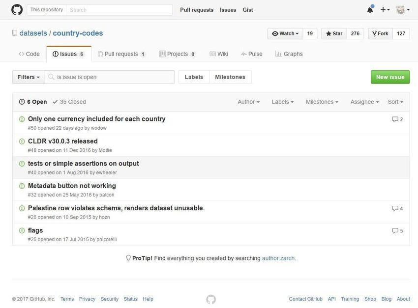
The Hotmaps project

The EU-funded project Hotmaps aims at designing a toolbox to support public authorities,
energy agencies and urban planners in strategic heating and cooling planning on local,
regional and national levels, and in line with EU policies.
In addition to guidelines and handbooks on how to carry out strategic heating and cooling
(H&C) planning, Hotmaps will provide the first H&C planning software that is

       User-driven: developed in close collaboration with 7 European pilot areas
       Open source: the developed tool and all related modules will run without requiring
       any other commercial tool or software. Granting free in use and access to the source
       code.
       EU-28 compatible: the tool will be applicable for cities in all 28 EU Member States

The consortium behind

                                                                                        3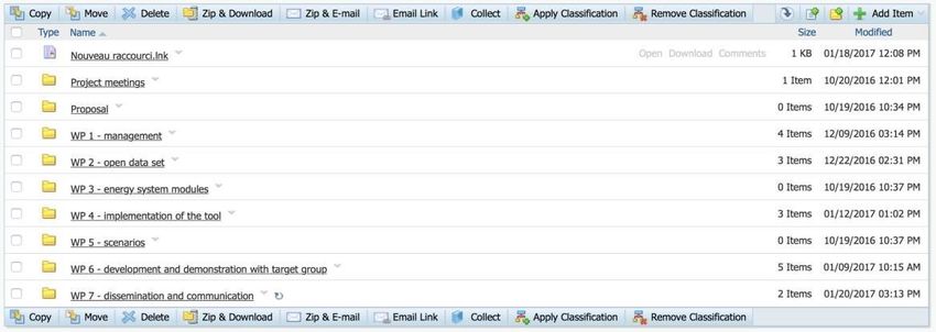
Table of Contents
1. Objectives                                                                                                        10
2. Types of managed data in Hotmaps                                                                                  10
3. Data collection framework                                                                                         11
 3.1 External data sources........................................................................................11
 3.2 Data quality process..........................................................................................12

4. Best practices and guidelines to Data Management in
relation to Hotmaps                                                                                                  13
 4.1 Data vocabularies and metadata .....................................................................17
 4.2 Name Conventions ...........................................................................................17
 4.3 Sensitive data ....................................................................................................19
 4.4 Data formats .....................................................................................................22
 4.5 Data preservation .............................................................................................23
 4.6 Feedback ....................................................................................................... 26
 4.7 Data enrichment ...............................................................................................27
 4.8 Data license .......................................................................................................27
 4.9 Provenance and quality ....................................................................................28
 4.10 Data versioning ...............................................................................................28
 4.11 Data identification ..........................................................................................30
 4.12 Data access......................................................................................................30
 4.13 General Data Protection Regulation………………………………………………………….. 31
 4.14 Conclusion of best practices and guidelines……………………………………………. 32

5. Allocation of resources                                                                                           32
 5.1 Costs estimate to make the open-data FAIR ................................................. 32
 5.2 Data management responsibilities ..................................................................33
 5.3 Data management plan updates and revisions ...............................................34

Conclusions                                                                                                          35
References                                                                                                           35

                                                                                                                              4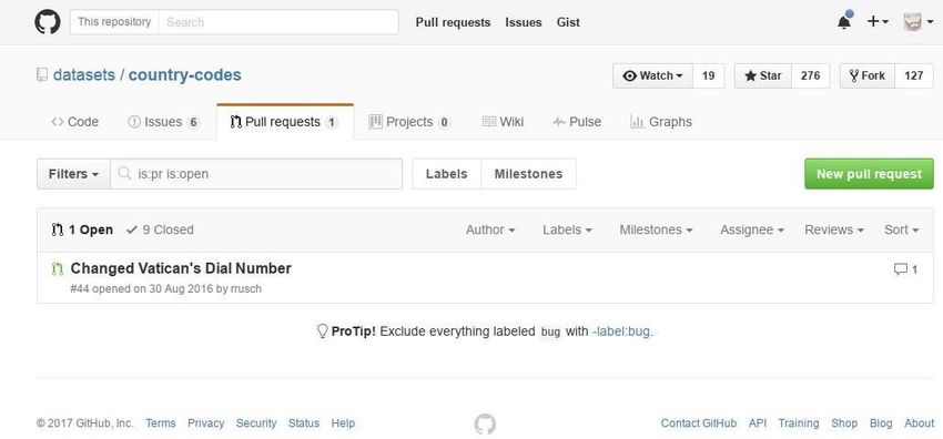
According to the ”Guidelines on FAIR Data Management in Horizon 2020 (Version 3.0, 26 July
2016)” the Data Management Plan should address following issues - next to the listed points,
please find the text section of the given Data Management Plan in which those are treated:

  DATA SUMMARY

  State the purpose of the data collection/generation                 1. Objectives, Page
                                                                      10

  Explain the relation to the objectives of the project               4 Best practice and
                                                                      guidelines to data
                                                                      management in
                                                                      relation to Hotmaps,
                                                                      Page 13

  Specify the types and formats of data generated/collected           4.4 Data formats,
                                                                      Page 22

  Specify if existing data is being re-used (if any)                  3.1 External data
                                                                      source, Page 11

  Specify the origin of the data                                      3.1 External data
                                                                      sources, Page 11

  State the expected size of the data (if known)                      4.5 Data
                                                                      preservation, Page
                                                                      23

  Outline the data utility: to whom will it be useful                 2. Types of managed
                                                                      data in Hotmaps,
                                                                      Page 10

  MAKING DATA FINDABLE, INCLUDING PROVISIONS FOR METADATA [FAIR DATA]

  Outline the discoverability of data (metadata provision)            4.1 Data
                                                                      vocabularies and
                                                                      metadata, Page 17

  Outline the identifiability of data and refer to standard 4.11 Data
  identification mechanism. Do you make use of persistent and identification, Page
  unique identifiers such as Digital Object Identifiers?      30

  Outline naming conventions used                                     4.2 Name
                                                                      conventions, Page 17

  Outline the approach towards search keyword                         4.1 Data
                                                                      vocabularies and
                                                                      metadata, Page 17

  Outline the approach for clear versioning                           4.10 Data versioning,
                                                                      Page 28

                                                                                            5
Specify standards for metadata creation (if any). If there are no 4.1 Data
standards in your discipline describe what metadata will be vocabularies and
created and how                                                   metadata, Page 17

MAKING DATA OPENLY ACCESSIBLE [FAIR DATA]

Specify which data will be made openly available? If some data is   4.8 Data license,
kept closed provide rationale for doing so                          Page 27

Specify how the data will be made available                         4.4 Data formats,
                                                                    Page 22

Specify what methods or software tools are needed to access the 4.4 Data formats,
data? Is documentation about the software needed to access the Page 22
data included? Is it possible to include the relevant software (e.g.
in open source code)

Specify where the data and associated metadata, documentation       4.4 Data formats,
and code are deposited                                              Page 22

Specify how access will be provided in case there are any           4.4 Data formats,
restrictions                                                        Page 22

MAKING DATA INTEROPERABLE [FAIR DATA]

Assess the interoperability of your data. Specify what data and 4.1 Data
metadata vocabularies, standards or methodologies you will follow vocabularies and
to facilitate interoperability                                    metadata, Page 17

Specify whether you will be using standard vocabulary for all data 4.1 Data
types present in your data set, to allow inter-disciplinary vocabularies and
interoperability? If not, will you provide mapping to more metadata, Page 17
commonly used ontologies?

INCREASE DATA RE-USE (THROUGH CLARIFYING LICENSES) [FAIR DATA]

Specify how the data will be licenced to permit the widest reuse    4.8 Data license,
possible                                                            Page 27

Specify when the data will be made available for re-use. If 4.8 Data license,
applicable, specify why and for what period a data embargo is Page 27
needed

Specify whether the data produced and/or used in the project is 4.8 Data license,
useable by third parties, in particular after the end of the project? Page 27
If the re-use of some data is restricted, explain why

Describe data quality assurance processes                           3.2 Data quality
                                                                    process, Page 12

                                                                                        6
Specify the length of time for which the data will remain re-usable   4.5 Data
                                                                      preservation, Page
                                                                      23

ALLOCATION OF RESOURCES

Estimate the costs for making your data FAIR. Describe how you        5.1 Cost estimate to
intend to cover these costs                                           make the open-data
                                                                      FAIR, Page 31

Clearly identify responsibilities for data management in your         5.2 Data
project                                                               management
                                                                      responsibilities, Page
                                                                      33

Describe costs and potential value of long term preservation          5.1 Costs estimate to
                                                                      make the open-data
                                                                      FAIR, Page 32

DATA SECURITY

Address data recovery as well as secure storage and transfer of       4.12 Data access,
sensitive data                                                        Page 30 and 4.5 Data
                                                                      preservation Page 23

ETHICAL ASPECTS

To be covered in the context of the ethics review, ethics section of 4.3 Sensitive data,
DoA and ethics deliverables. Include references and related Page 19
technical aspects if not covered by the former

OTHER

Refer to other national/funder/sectorial/departmental procedures      3.2 Data quality
for data management that you are using (if any)                       process, Page 12

                                                                                           7
Executive Summary
Hotmaps is part of the H2020 Pilot on Open Research Data - a plan established to maximise
access and reuse of projects research data. Data Management Plans (DMPs) describe how to
make research data findable, accessible, interoperable and reusable (FAIR). Towards this goal,
we present the following DMP, which describes the life cycle management of data sets
processed or generated during/beyond Hotmaps. The DMP also documents how data types,
methods and standards are exploited for verification and re-use and how they are curated
and preserved.
Hotmaps’ DMP implements the “Guidelines on FAIR Data Management in Horizon 2020
(Version 3.0, 26 July 2016)” and follows the new W3C draft on “Data on the Web Best
Practices (31 January 2017)” and refers to their content as baseline for its research and
innovation actions.
Hotmaps discusses specifically the twelve challenges for web data publishing brought up by
the W3C guideline (key player in semantic web technologies), in particular referring to their
harmonization within the project. Providing information on our data and the manual data
collection method is a focus of the Hotmaps community, even after project’s completion.
Hotmaps collects data establishing their relation to other Research & Innovation Action (RIA)
and Cooperation Support Action (CSA) activities – THERMOS, Planheat, Heat Roadmap Europe
4 (HRE 4) – reviewing all together 26 projects.
Hotmaps will open the data sets used as inputs for the Hotmaps toolbox at EU28 level and
open the results of the model and scenarios for the entire EU.
All the data coming from the Pilot areas (WP6) or uploaded by the user of the Hotmaps
toolbox platform will be treated as sensitive and confidential data.
8Introduction - Hotmaps objectives
The overarching goal of Hotmaps is the development of an open source heating / cooling
mapping and planning toolbox and to provide default data for EU28 at national and local
level. These data and tool allow public authorities to identify, analyse, model and map
resources and solutions to supply energy needs within their territory of responsibility in a
resource and cost efficient way. Those results will help authorities to develop heating and
cooling strategies on local, regional and national scale which are in line with RES and CO2-
Emission targets on national and EU level.
This leads to three main project objectives:
1. Develop an open source toolbox (Hotmaps toolbox) that will effectively and
comprehensively support local, regional and national heating and cooling planning
processes.
2. Provide a default open data set to lower the initial barrier in applying the tool for
regions across EU-28 member states and include the ability that the users can adapt
and provide more accurate, large and complex data for data for a specific area.
3. Provide a tested and user friendly open source software tool which is based on user
needs. Guarantee wide usability, flexible adjustability and concrete application of the
tool within and beyond the project duration.
91. Objectives
The DMP defines and describes data management policies applied by the Consortium to the
datasets generated by the project. It represents a novel and important tool of Horizon 2020
projects to describe data generation, exploitation, accessibility, re-use and preservation.
Hotmaps, a Research & Innovation Action (RIA) project, investigates Energy Efficiency (EE)
and energy demand for heating, cooling and domestic hot water (DHW) in EU households,
services, industry and transportation. Hotmaps collects and generates new data at a spatially
disaggregated level (with vector data at NUTS0, NUTS1, NUTS2, NUTS3 level or with raster
data with a resolution of 250 x 250 m or higher) to allow especially public authorities to
identify, analyse, model and map resources and solutions covering responsibly and cost-
efficiently their local supply needs. These results will help authorities to develop heating and
cooling (H&C) strategies on local, regional and national scales in line with RES and CO2-
Emission targets at national and EU levels.
Data of the default data set, should be publicly available, comparable, correct, up-to date,
complete, compelling and, most importantly, findable, accessible, interoperable and reusable
(FAIR). The data will be ideally preserved by Hotmaps’ active community of users and
developers. Hotmaps extracts and harmonizes data from different sources like, for example,
project websites, deliverables, publications (journal papers, conference proceedings etc.), tools
and feedbacks from partners. This strategy will foster reuse of results, increase collaboration
and help identifying common data requirements.
This DMP shows the approach that Hotmaps has been chosen to deal with expected project
results. It first clarifies the types of data managed and the methods used to collect and
harmonize them and then explains how Hotmaps deals with the challenges of data
management and publication (Guidelines on FAIR Data Management in H2020 [1] and W3C
Proposed Recommendation “Data on the Web Best Practices” [2]). It should be noted that
the data types Hotmaps will collect and generate do not necessarily endorse all the
recommendations laid out by the European Commission (EC) and W3C.
2. Types of managed data in Hotmaps
Hotmaps, as a RIA, will collect data in the form of vector (GIS vector format) or raster. It will
also generate new data applying statistical models to fill in missing information (WP2), energy
models (WP3) to estimate the main energy parameters and generate data for scenarios (WP5).
Collected and processed data, available in vector form, raster maps and downloadable
databases, will especially benefit from:
● Public authorities: administrative staff in the public authorities at local, regional and
national levels, responsible for energy and/or spatial planning, strategy and policy
development in the heating and cooling sector;
● Planners and consultants: although public authorities represent the main target group
of the toolbox, its main users in the case of small cities/municipalities will be
professional planners and consultants;
10● Energy agencies: staff of local, regional and national energy agencies assisting public
authorities in the planning and strategy development processes for H&C;
● Open source modelling community: staff of scientific and academic institutions as
well as professionals from the private sector focusing on the development of
methods and tools for the analysis of energy systems, energy management and
spatial representation tools, dedicated to the open source concept and to the
extensive sharing of ideas and developments.
● The updated data will be made available to the Technical Board, composed by the
project partners (TUW, EURAC, CREM, HES-SO, Fraunhofer, AAU, PlanEnergi and e-
think).
Hotmaps aims to build - around the data collected and the tool developed during the project
- an open community of users and developers interested in the project’s topic. The creation
of an open community of people working at different aspects of Hotmaps energy systems
(data, tools, models, scenarios, etc.) will be paramount to update and improve the main
outputs beyond the end of the project.
3. Data collection framework
3.1 External data sources
As shown in the previous section, a main outcome of Hotmaps in terms of managed and
published data is H&C demand data at spatially disaggregated level (vector data at NUTS0,
NUTS1, NUTS2, NUTS3 level in CSV format with NUTS code and year or raster data with a
resolution of 250 x 250 m or higher in compressed format). Data will concern four sectors of
the EU market: residential, service, industry and transportation. Hotmaps will review,
categorize and compare different RIA projects to encourage knowledge sharing and to increase
the impact of project results. In particular, due to a number of shared points, we describe
how H2020 HRE4 shares methods, approaches, data and results with Hotmaps. We compared
data requirements and expected results of both projects and identified their possible synergies.
We also described how the two projects differ and where/in what measure data exchange is
limited (see working document “Deliverable 2.0 Synergies between Hotmaps and HRE4”).
Data will also be collected from national statistics to increase data coverage and availability
and create a list of national contact points (NCPs), which can offer support to this and other
projects during data collection.
Concerning the spatial data several sources like EU agencies (EUROSTAT, European Environment
Agency - EEA) and data of previous EU-projects (e.g. EEA [3]) will be used to
provide/integrate information to the Hotmaps toolbox concerning: land-cover, population,
urban-atlas, urban morphological zones, solar potentials, shallow geothermal potentials, etc.
The list of input datasets to be used in the project will be included in deliverable D2.2 “Open
datasets” due on month 18 (March 2018).
113.2 Data quality process
Data quality, completeness, accuracy, and reliability are very important aspects in the process
of establishing the datasets within the project. Among others, the following main points will
be taken into consideration: i. Data inventory, ii. Data processing, iii. Data definition and
comparability:
i. Data inventory
The output datasets to be generated within the project will be published in the GitLab public
repository within the deliverable D5.2 “Scenarios for EU-28” and D2.2 “Open dataset ”due on
month 18 (March 2018).
One of the major challenges in developing an inventory of energy demand and resource data
for heating, cooling, and DHW supply in different sectors, is to provide a complete list of all
existing information. In general, the advantage of using data that comes from EU wide
information providers and EU projects is that this data is available for a large territory (e.g.
ESPON [4]).
Filling in the data gaps implies not only extrapolating and assembling data from large data
tools available online (e.g. Building observatory [5]), but also researching data source-by-
source from single scientific literature sources such as journal papers, conference proceedings
and project deliverables. Only through such an in-depth approach can the already mentioned
lacks of data per energy type and nation be filled.
One important aspect of the data inventory is to ensure that the information can be
understood and interpreted correctly by users. This requires a compilation of clear metadata
description, annotation, contextual information and documentation [1].
The data documentation will provide standardized structured information explaining the
purpose, origin, time references, geographic location, creator, access conditions and terms of
use of the data collection, following, as much as possible, the W3C Proposed
Recommendations on the Data on the Web Best Practises.
The whole open dataset collected and produced within the Hotmaps project will comply with
the INSPIRE Directive 2007/2/EC [6] protocols and standards. CREM in WP4 is responsible to
develop and deploy the Hotmaps unique interface to access all data available in the public
GitLab repositories, the open data sets will be published using the protocols defined by the
Open Geospatial Consortium that are compliant to the INSPIRE directive.
ii. Data processing
Data processing are performed mainly in WP2 (Open Data Set for EU-28), WP3 (Development
of energy system planning modules) and WP5 (Scenarios and regional scale consistency).
In WP2, much effort is going to be allocated to analyse sources, assess the reliability of the
gathered data and complement the missing gaps by in-depth local surveys/inquiries. The
Consortium will correctly distinguish between different kinds of information by analysing the
methodology related to the data found. In case of missing data documentation, these will be
excluded from the database. All collected information on heating, cooling and DHW (with a
12unit of kWh/m² y, Mm², etc.) will be filtered and evaluated statistically. As far as the number
of sources allows, the coefficient of variance will be used as statistical indicator of uncertainty
to exclude values outside a range of plus or minus one standard deviation around the average.
The filtered values will be used to compute a more robust average. Further types of
information will be collected to validate the indications obtained per country and sector to
assess the reliability of the data. (E.g. population size per county, percentage of heated,
cooled and total floor area, gross domestic product - GDP, economic growth indicators and
energy related funding/financing schemes).
In WP3, a set of tools and modules will be developed to process and analyse the default data
set produced in WP2 in order to support the planning process of the energy systems.
WP5 will prepare and compute the scenarios (e.g. on the development of buildings
renovation activities and related heat demand or the expansion of district heating) using the
modules and tools developed in WP3.
iii. Data definition and comparability
Despite most data providers utilizing standardized data formats and units, this does not
necessarily mean that data are fully comparable. Adjusting differences and inconsistencies
among different measures, definitions, assumptions, methods, time references and
specifications to improve data comparability is one of the most important aspects of the
whole process of data elaboration.
Data will be collected for each country with reference to the most recent year and to a
previous baseline year. Apart from the use within the Hotmaps toolbox and other existing
tools the developed database including the documentation in this project is expected to
improve data quality for user, add value to already existing data and provide data needed to
monitor the progress towards the achievement of the goals defined in EU energy related
Directives.
4. Best practices and guidelines to
Data Management in relation to
Hotmaps
The DMP describes what data will the project generate, whether and how will it be exploited
or made accessible for verification and re-use, and how will it be curated and preserved.
Moreover, a crucial point of the DMP is to describe how research data are made findable,
accessible, interoperable and reusable (FAIR). The Consortium is expected to [1]:
● Deposit research open-data in a repository and take measures to make it possible for
third parties to access, mine, exploit, reproduce and disseminate;
● Use the open-data, including associated metadata, to validate the results presented
in scientific publications;
13● Treat other data, including associated metadata, as specified and within the
deadlines laid down in the DMP.
Hotmaps manages the generated data using the following web platforms:
1. Hotmaps website (public) http://www.hotmaps-project.eu/: the website provides
information about the project’s objectives, partners and results, as well as about upcoming
events related to project topics.
2. LiveLink - developed and maintained by OpenText: the platform is meant for private and
project internal use only to easily share documents and contacts between the partners during
the project (e.g. deliverable drafts, project management documents, presentation slides,
project related literatures, etc.).
3. The Hotmaps toolbox - hosted by Energy Cities after the project’s end and by HES-SO
during the project - will publish tools and models developed by Hotmaps enabling users to
execute and test different models for their region of interest, to refine their own data
analysis and to export the results in a common format to support the strategic development
of their area. Any other user data compatible with the Hotmaps toolbox, and complementing
the default dataset, will remain private and treated as confidential.
4. All the datasets of the Hotmaps projects will be shared under the following GitLab web-
page (https://gitlab.com/Hotmaps). Each dataset will have a dedicated Git repository. The
repository will be freely accessible without authentication for all the datasets that the project
will released as open-data, and will required user authentication for all the datasets that are
classified as not publishable due to data sensitiveness and confidentiality. In case the terms
and conditions underlying the use of a GitLab repository are not satisfying to the user’s
requirements, the HotMaps toolbox should foresee other possibilities to work with data stored
locally. The open-data datasets will be available for all regions of EU-28 without any specific
condition and restriction. The use of a Version Control System such as git to handle the public
project datasets can help the Hotmaps project follows the Guidelines on FAIR Data
Management in Horizon 2020 (Version 3.0, 26 July 2016) [1] - as recommended by European
Commission - and the Proposed Recommendations “Data on the Web best practices” by the
W3C communities (31 January 2017) [2], promoted by Hotmaps’ partners through its
dissemination activities in WP7.
The Horizon 2020 guidelines address the following topics:
● Data set reference and name: to enable identification, search, and retrieval of data.
Each published data set is named and accessible through a unique and identifiable
Uniform Resource Locator (URL) provided by git and published and reachable on the
GitLab web-platform;
● Data set description: addressed by Hotmaps in section 4.4 to define data format and
information included;
● Standards and metadata: Hotmaps defines a dedicated vocabulary and set of
metadata schemes to describe energy data collected at EU28 level. Each published
14dataset present in the git repository and published on the GitLab platform will use a
unified communication format, for instance the JSON for Linking Data (json-ld) [7]
format to provide metadata based on a common format easily readable by both
humans and machines. EURAC in coordination with the other technical partners will
prepare a document with the vocabulary and the main features that are needed to
describe and classify consistently the energy data sets. The vocabulary will use and
extend the wiki-page defined by the Open Energy Model Initiative
(https://wiki.openmod-initiative.org/wiki/Category: Glossary). The list of required
features and classification of the energy data sets will be shared and discussed in a
public dedicated Hotmaps repository managed by EURAC. CREM and HESO will
support the project in converting the previous documents into a specific schema. The
schema will be described in section 4.1 and will be defined in Task 4.4 and delivered
at the end of the project. The definition of a shared specific schema and vocabulary
to describe energy data sets will provide the consumer with a better understanding
of the collected and enriched data;
● Data sharing: this term refers to the way data are shared - including access
procedures, license, and management of sensitive data - and will be further
developed in section 4.3, 4.4, 4.7, 4.8, 4.9 and 4.12;
● Archiving and preservation deals with the procedures for long-term preservation of
the data. It includes for how long data should be preserved, their approximate end
volume, associated costs and recovery plan. The implementation in Hotmaps is
described in section 4.5.
15Figure 1 Best practices addressing the challenges faced when publishing data on the web
[2]
164.1 Data vocabularies and metadata
This challenge is relevant to achieve semantic interoperability between data producers and
consumers. The solution proposed in the semantic web community is to agree on a shared
vocabulary and to make it available in an open format. Hotmaps will use Join UP Glossary [8]
and enrich its existing vocabulary adding, when needed, new definitions to the wiki page of
the OpEnMod Initiative [9] community. The keywords used by the project to describe the
dataset will be chosen from the wiki page of the OpEnMod Glossary.
Sharing common data is important both among Hotmaps Consortium partners and among
external data consumers, also to avoid ambiguity and clashes. This remains however a
challenge, due to the wide range and diversity of covered topics, and requires finding a good
compromise at the level of common comprehension.
Hotmaps will define its own set of schemas to semantically describe the data collected and
produced within the project whenever there is a lack of vocabulary definitions that satisfy the
project requirements. The term Energy is missing in both the Data Catalog Vocabulary (DCAT)
[7] and the Semantic Interoperability Community (SEMIC) [10] vocabulary. schema.org
provides a basic definition for Energy [11], without however providing any distinction on the
form of energy (i.e. electric, thermal, kinetic, chemical etc.), the balance role (i.e. produced,
consumed, imported, exported), the resources used (i.e. fossil, nuclear, renewable, etc.), the
technology used to produce it (i.e. photovoltaic, gas turbine, hydro, etc.), the data type (i.e.
measured, estimated, forecasted, etc.), the time range (i.e. yearly, monthly, daily, etc.) and
the spatial resolution (i.e. single component, an entity as a plant or a building, an area as a
municipality, a region or a country). The schema definition will be done together with other
EU funded projects (i.e. HRE4, ExcEED, etc.) and open-source communities interested in the
topic (i.e. OpEnMod [11], etc.).
4.2 Name Conventions
The consortium defines two distinct name conventions: one is dedicated to the project
documents and one to the data collected and elaborated that are used as default inputs for
the Hotmaps toolbox and that will be released as open-data or the inputs used internally
assess some specific parameter for the models and scenarios.
Hotmaps documents
The Hotmaps documents are organized in a hierarchical file tree that reflects the main project
structure. At the first level there is the name of the WP, inside there is a dedicated directory
for each task and a dedicated directory with the minutes of the WP meetings and telephone
conferences. Each task’s directory can contain another directory with the minutes (if
necessary) and the other documents and investigations performed during the task’s activities.
See the structure reported below as an example of the hierarchical structure of the Hotmaps
documents.
17Figure 2 Hotmaps hierarchical file tree
18Hotmaps data
Hotmaps data can be private or public and the potential users must not be aware of the
project work packages and tasks. The title of all the data repositories will start with: “Data
package: ...“.
The name of the repository will use keywords defined in a dedicated wiki page of the repository
containing the list of all the Hotmaps datasets. The wiki page will be created and managed
by EURAC, all partners will contribute defining and refining the names.
The first element will define the spatial resolution of the data set (e.g.NUT{0|1|2|3} or
LAU{1|2}). Then we will use the keywords defined in the wiki-page to describe the dataset.
So for example the H&C demand of the building sector at NUTS3 could be:
NUTS3_building_HC_residential_demand.
4.3 Sensitive data
Hotmaps is committed to follow best practices in collecting, processing, and sharing personal
data1 and confidential data2 that may be generated or processed further during the project.
In this DMP, we designate such data as sensitive data. The Consortium is aware that
mishandling of sensitive data may lead to damages to individuals or organizations and may
breach national, EU and international law.
To support best practices for sensitive data, data publishers should identify all sensitive data,
assess their risk exposure, determine their intended use, user audience and any related
policies; obtain appropriate approval and determine appropriate security measures for data
protection (which should also account for secure authentication and use of HTTPS).
Use-cases generated during the Hotmaps originate from publicly available deliverables.
Internal project documents and personal data, in the form of contact details (addresses), are
only shared through the internal LiveLink and in any case cannot be disclosed without a
1
As defined in letter (a) of article 2, Directive 95/46/EC, that states ‘personal data’ shall mean any information
relating to an identified or identifiable natural person (‘data subject’); an identifiable person is one who can be
identified, directly or indirectly, in particular by reference to an identification number or to one or more factors
specific to his physical, physiological, mental, economic, cultural or social identity.
This definition will be replaced from the 25th of May 2018 by the slightly different definition adopted in point (1)
of article 2, Regulation (EU) 679/2016, that states ‘personal data’ means any information relating to an identified
or identifiable natural person (‘data subject’); an identifiable natural person is one who can be identified, directly
or indirectly, in particular by reference to an identifier such as a name, an identification number, location data, an
online identifier or to one or more factors specific to the physical, physiological, genetic, mental, economic,
cultural or social identity of that natural person.
2
We refer to data that is excluded from access on the grounds of protection of national security (i.e. State
security), defence, or public security, or statistical confidentiality, it is used under a confidentiality agreement or
protected by rights of third parties, like the right on trade secrets as defined in point (1) of article 2, Directive (EU)
2016/943 that states ‘trade secret’ means information which meets all of the following requirements: (a) it is
secret in the sense that it is not, as a body or in the precise configuration and assembly of its components,
generally known among or readily accessible to persons within the circles that normally deal with the kind of
information in question; (b) it has commercial value because it is secret; (c) it has been subject to reasonable steps
under the circumstances, by the person lawfully in control of the information, to keep it secret.
19permission by the data subject or in breach of the data license, if processing previously
collected secondary data.
Data coming from the Pilot areas during the Hotmaps project will be used to test and tune
the tools and algorithms that will be included in the Hotmaps toolbox and shared between
the project partners using the data package format as described in section 4.5 through a
private GitLab repository as described in section 4.12.
Sensitive data collected through interviews and questionnaires will be stored in a dedicated
GitLab private repository using the frictionless data formats for (meta-)data. The data will be
anonymized before sharing and publish the dataset. The Consortium will review all
questionnaires or surveys before ensuring that they comply with the EC standards [13]. This
sets down strict policies for managing and anonymizing personal data.
Hotmaps investigates energy efficiency and energy demand for heating, cooling and DHW in
EU households, services, industry and transportation. Hotmaps collects and generates new
data at a spatially disaggregated level (with vector data at NUTS0, NUTS1, NUTS2, NUTS3
level or with raster data with a resolution of 250 x 250 m or higher) to allow especially public
authorities to identify, analyse, model and map resources and solutions covering responsibly
and cost-efficiently their local supply needs. Therefore the main ethical issues arising from
the project are concerning data protection and privacy as well as informed consent.
In course of the project human participants are involved through interviews, training and
workshops. All other data necessary for the determination of the project results will be at
higher aggregation level and compiled by external information sources such as statistical data
or published results of other research projects.
Particular attention will be devoted to check that datasets to be published do not include
personal data (for example, because clusters of data could refer to individual persons) or
other sensitive data.
The data and information collected in interviews, surveys and workshops will only be shared
anonymised or, where this cannot be the case, the relevant persons/organizations will be
asked for permission to publish related information. No sensitive data will be published without
explicit permission of the affected persons.
This data collection may include sensitive information, e.g. information about personal values.
It will be made clear to the participants that participation is entirely voluntary, and that
they will be able to withdraw from the study at any time and can ask researchers to delete
their data from the study at any time.
In processing, analysing and publishing the data from the research, we will follow standard
procedures such as assigning numbers and/or pseudonyms to participants. We will not use
the responses of any one individual, household or organisation in publications in such a way
that they could be identified. To avoid the possibility of connecting reported data to specific
companies or persons we will just report aggregated data. Participants will be informed that
the personal data will be used for research purposes only and kept confidential at all times.
Personal data, which is necessary for the interviews, is collected for specified, explicit and
legitimate purposes and not further processed in a way incompatible with those purposes.
20And they are kept in a form which permits identification of data subjects for no longer than is
necessary for the purposes for which the data were collected or for which they are further
processed. Personal data will be processed pursuant to Directive 95/46/EC and Regulation
(EU) 679/2016 (that will apply and replace the Directive from the 25th of May 2018) and
applicable national laws.
The ethics and privacy requirements that the project must comply with will be included in
deliverable D8.1 POPD - Requirement No. 1 to be delivered in month 6 (March 2017):
● Copies of opinion or confirmation by the competent Institutional Data Protection
Officer and/or authorization or notification by the National Data Protection Authority
must be submitted (whichever applies according to the Data Protection Directive EC
Directive 95/46, currently under revision, and the national law);
● If the position of a Data Protection Officer is established, their opinion/confirmation
that all data collection and processing will be carried according to EU and national
legislation, should be submitted;
● If the project involves sensitive data, justification must be given for the collection
and/or processing of personal such data;
● Detailed information must be provided on the procedures that will be implemented
for data collection, storage, protection, retention and destruction and confirmation
that they comply with national and EU legislation;
● Detailed information on the informed consent procedures that will be implemented
in regard to the collection, storage and protection of personal data must be
submitted on request;
● Templates of the informed consent forms and information sheet must be submitted.
With regard to the Pilot areas activities (WP6), planning processes will be carried out applying
the Hotmaps database and toolbox, and thus demonstrating its use in course of strategic heat
planning. During the WP6 activities each Pilot Areas will try to characterize: What kind of H&C
are in use? How are H&C distribution systems in buildings? Which fuels are used? Analysis of
stakeholders within H&C sector (utilities, authorities) and decision makers. Organisation and
regulation of the sector. Infrastructure for electricity, gas and heat. Description of barriers for
district heating and cooling. Map the present H&C demand in buildings and industrial process.
Identify and locate resource and fuel potentials (excess heat, geothermal heat, biomass for
burning and gasification, biomass for biogas, heat sources for heat pumps, solar, wind).
Calculate a reference situation for the city/region, including fuel consumption, environmental
consequences and economic consequences. Define and compare district heating and cooling
scenarios with individual supply. As last activities of WP6 each Pilot Area elaborates and
formulate a H&C strategy and description of how it can be realized stepwise.
All the data and information collected and elaborated for the Hotmaps Pilot Areas and more
generally collected by the Hotmaps toolbox web platform will be treated as sensitive not
publishable data sets, unless the related partners agree on a deviating procedure, in line with
privacy guidelines.
214.4 Data formats
Hotmaps collects data and organizes information in the form of vector data (geometry &
attribute table at NUTS 0, 1, 2 and 3 or different geographical unit/geometry) or raster data
(covering the whole EU28 with a spatial resolution of 250 x 250 m up to 100 x 100 m).
Any collected, enriched and opened data is published on https://gitlab.com/Hotmaps.
Making the data sets openly accessible over the internet, although available for editing only
to community members. The main audience of this information is humans and machines (for
automatic evaluation); its main aim is to trigger further discussions and information exchange
within the Hotmaps community and other research projects/institutions.
A machine readable format is needed for automatic evaluation. Each dataset is a self-
contained repository following the standard Data Package format defined and promoted by
Frictionless data [14].
The Hotmaps project decided to adopt the Data Package format for its clear and simple
principles and because is based on the lessons learned by the CKAN and Open Knowledge
Foundation (OKF) during the last years of data collection, harmonization and publications. As
stated by Frictionless data the inspiring principles of the Data Package format are:
1. Focused: Focus on one part of the data chain, one specific feature (e.g. packaging),
and a few specific types of data (e.g. tabular).
2. Web-oriented: Build for the web using formats that work naturally with HTTP such as
JSON, a common data exchange format for web APIs, and CSV, which is easily
streamable.
3. Distributed: Design for a distributed ecosystem with no centralized, single point of
failure or dependence.
4. Open: Make things that anyone can freely and openly use and reuse with a
community that is open to everyone.
5. Built Around Existing Tooling: Integrate with existing tools while also designing for
direct use—for example, when a Tabular Data Package integration is unavailable, fall
back to CSV.
6. Simple: Keep the formats and metadata simple and lightweight, and make things easy
to learn and use by doing the least required.
Each data set will be published as a self contained git repository respecting the technical
specifications defined by the Data Package format. The repository consists of a set of text
files encoded in Unicode Transformation Format (UTF-8):
● README.md: using MarkDown format, provides basic information such as dataset
title, content description, methodology/process for data generation; references to
input data sources;
22● The datapackage.json file: following the Frictionless Data specifications, provides
information in a machine-friendly format. The json file will contain the following fields:
name, title, description, license, homepage, author, contributors, sources and
schemas. The collected data will be offered as a Data Package format - a standard
defined and promoted by Frictionless data using the json-ld format to for the main
metadata, based on an ontology derived from the vocabulary and schema discussed
in section 4.1;
● A directory data that contains the raw data, preferably in text format, so for instance
instead of using shape file that is a binary format and required a dedicated software,
use a CSV file with a column with the geometry inserted as Well Know Text (WKT)
format, or use a format that can be directly be rendered in a web-browser such as
geo-json or topo-json. For the raster map instead due to their size we will use a
compressed format such as GeoTiff. Not external software is required to access the
raw data except to a text editor, if a binary format is required in the README.md file
there will be a section indicating which open-source tools are available to open and
work with this special file format;
● If some scripts are needed to load and processing the data these scripts will be
included in the repository under a dedicated directory called scripts.
EURAC will be in charge to check the conformity to the Frictionless data specifications and to
foster the use of common keywords and definitions, to achieve a data set that is harmonized
and consistent.
4.5 Data preservation
This section describes best practices related to open-data preservation:
● The coverage of a dataset should be assessed prior to its preservation - check whether
all the resources used are either already preserved somewhere or provided along with
the new dataset considered for preservation.
● Data depositors willing to send a data dump for long term preservation must use a
well-established serialization - Web data is an abstract data model that can be
expressed in different ways (RDF, JSON-LD etc.). Using a well-established serialization
of these data increases its chances of re-use without temporarily limit the dataset re-
usability.
● Preserved datasets should be linked with their "live" counterparts - a link is
maintained between the URL of a resource, its most up-to-date available description,
and other preserved descriptions. The description should notify in case the resource
does not exist anymore and refer to its last available description.
Energy Cities is responsible for Hotmaps Communication and Dissemination, starting with the
third year of the project, Energy Cities will host the Hotmaps database, containing the open-
23data set as well as private data sets uploaded by users and pilot areas. CREM, EURAC and
TUW will support Energy cities with initiating the data management task. User data from Pilot
areas will be hosted locally or in private git repositories (to be created by the user), and
accessed by the Hotmaps toolbox and partners.
The following personnel will work on this task:
● Pietro Zambelli (EURAC): holds a PhD in Environmental Engineering. He is expert in
developing new GIS models and tools for the spatial and temporal data analysis.
Pietro Zambelli designed several spatial database structures to collect energy data
coming from monitored systems and to collect data on produced/consumed energy
per different sectors and from different resources. He is full skilled in several
computer languages: Python, Rust, C, SQL, Fortran, Matlab, R, Bash, Latex, Logo,
Javascript and golang mainly for GIS and data processing and analyses.
● Sara Fritz (TU Wien): holds a PhD in energy economics. Her research focus on energy
system modelling with special emphasis on spatial highly resolved district heating
expansion analyses. She participated in an interdisciplinary doctorate course at TUW,
with the aim to research and develop an interactive environment for analyzing
scenarios. Thus, she was involved in setting up a data exchange structure for the
developed URBEM Smart City Application and the corresponding compliance and
security criterias. She is experienced in Python, Matlab, R, QGis and GAMS.
● Olivier Lagarde (Energy Cities): holds a Master in Resources Management and a Master
in Digital Communications. He has 15 years of experience in software development,
IT coordination and digital communications. He has contributed to develop softwares
in the field of energy efficiency and coordinated the IT management and related
promotion and dissemination for initiatives and campaigns of the European
Commission - DG ENER over the last 10 years. He is skilled in several computer
languages (C, Java, Javascript, Postgresql, SQL), data management and programmes
assessment.
● Lesly Houndole (CREM): holds a Master in computer science. He has 8 years of
experience in software development. He is an expert in data modelling and Database
conception. He has been developing a lot of software for companies including an
application for the Technical Center of the European Space Agency (ESTEC-ESA) using
GPS, GALILEO, GLONASS data for analysing Relative RAIM (Receiver Autonomous
Integrity Monitoring) on a multi constellation (GPS + Galileo + SBAS). He is
experienced in object oriented programming (OOP), designs pattern, test driven
development , GIT, C, C++, Python, JAVA, JAVASCRIPT, Postgresql, PostGIS, SQL.
The database will be backed up at least weekly, depending on data traffic and volume.
The data volume is expected to be small for vector data, especially if we split the geometry
and the attribute table the NUTS3 areas at EU28 are less than 2000 items, therefore in most
of the case should be possible to store this data as plain uncompressed UTF-8 text documents
in CSV format (with a total size that is less than 250 Kb per data set). However for data with
high resolution in space (NUTS3) and time (hourly) the data size can became big and therefore
a different file format can be considered. On GitLab the free limit of the single file size in is
set to 100 MiB and the maximum size of the repository is set to 10 GiB. Raster data
24can reach a problematic size, for example the Corine Land Cover (CLC) is around 6.6 GiB for a
raster of 100 x 100 m of spatial resolution in the ASCII GRID uncompressed format. To avoid
to meet the GitLab size limits the Hotmaps raster data we will use a compressed binary
format (GeoTiff generated with the following options: ZLEVEL=9, COMPRESS=DEFLATE,
PREDICTOR=1, TILED=YES, TFW=YES), to contains as much as possible the final size of the data
set. These binary files will be managed with git Large File Storage [13] version control system
tool, that split and track the binary file in smaller binary chunks.
TITLE RASTER TYPE BYTES SIZE RESOLUTION FORMAT
CLC i32 6504320 6.5 GiB 100 x 100 m ascii
89.2
CLC i32 13316 MiB 100 x 100 m ascii.7z LZMA2
CLC f32 8021200 7.6 GiB 100 x 100 m ascii
106.1
CLC f32 108636 MiB 100 x 100 m ascii.7z LZMA2
80.0
CLC u16 83916954 MiB 100 x 100 m GeoTiff DEFLATE1
92.5
CLC f32 97028412 MiB 100 x 100 m GeoTiff DEFLATE1
Temperatu 55.3
re f32 56672 MiB 250 x 250 m GeoTiff DEFLATE1
Random u16 1264940 1.2 GiB 100 x 100 m GeoTiff DEFLATE1
Random i32 1414792 1.3 GiB 250 x 250 m ascii
83.0
Random i32 146308 MiB 250 x 250 m ascii.7z LZMA2
Random i32 1994848 1.9GiB 100 x 100 m GeoTiff DEFLATE1
Random f32 2521628 2.4 GiB 100 x 100 m GeoTiff DEFLATE1
198.2
Random u16 203008 MiB 250 x 250 m GeoTiff DEFLATE1
312.5
Random i32 320024 MiB 250 x 250 m GeoTiff DEFLATE1
394.4
Random f32 403852 MiB 250 x 250 m GeoTiff DEFLATE1
Table 1 Raster file size and formats for a single temporal step.
25Assess the total volume of the raster data sets repository size can be difficult because can
change a lot by the raster type (Int32, UInt16, Float32, etc.) and by the raster value see for
example raster with the same dimension and resolution can vary from 55 MiB up to 394.4
MiB. Therefore, if we estimate an average repository dimension for raster data of around 500
MiB and assess at the end of the project to open 100 raster dataset we will reach a total
volume for repository of the generated dataset of around 60 - 50 GiB.
As it concerns free and open data, there will not be any specific control to monitor data
copying on external personal devices (laptops).
Data will be available for import/export from and to existing energy models. The use of a
public interface to communicate from and to the developed modules will make the platform
easy to integrate and extend it to non-open-source solutions (e.g. EnergyPRO [15], Times
[16], etc.).
4.6 Feedback
The Hotmaps website is open for the community to contribute and provide feedback.
Feedback is also being elicited through the use of questionnaires and surveys. The latter data
are stored on a dedicated private GitLab repository, where they are analysed by the Technical
Board. All the published datasets can receive comments and open discuss on specific dataset
issues using the GitLab Issue page of each dataset repository.
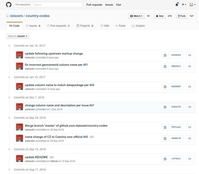
Figure 3 GitHub list of open issues concerning a specific dataset, similar interface is
provided by GitLab.
264.7 Data enrichment
Data enrichment is defined as a set of processes that can be used to enhance, refine or
otherwise improve raw or previously processed data [2]. Original Hotmaps documents
(deliverables, websites, and specifications) provide the necessary input to extract, categorize
and publish the required data, harmonizing information and, when necessary, enriching data
by getting feedback from project partners. References to original information sources are
always provided for verification. Moreover, the use of Git repository on GitLab, open the
possibility to people from outside the project to discuss and purpose data
refinement/enrichment through the use of the pull-request system.
Figure 4 GitHub list of open pull-request to change and improve the dataset, similar
interface is provided by GitLab.
4.8 Data license
A license is a legal document giving official permission to use data generated or used in a
project. According to the type of license adopted by the publisher, there might be more or
fewer restrictions on data sharing and reusing. In the context of Web available data, the
license of a dataset can be specified within the data, or in a separate document to which it is
linked. The HotMaps project will specify for each dataset repository the specific license of the
data, both in the README and in the meta-data json file.
All the data generated within the project will be released under an open-license (e.g. Creative
Commons Zero [17] or Open Data Commons Open Database License [18). Hence, they will be
potentially freely used, modified and shared by anyone for any purpose as stated by the
Open Knowledge Foundation in the Open Definition. The open data will be also shared as
linked open data through existing dedicated portals in line with the European Union Open
Data Portal [19].
27Within the deliverable D2.2 “Open Dataset”, all the input data sets for the Hotmaps toolbox
will be published on the GitLab dedicated page and the deliverable will include a detailed
table with the license for each input dataset present in the repository. Moreover, the main
Hotmaps data outputs, such as the scenarios will be published in the GitLab repository in
concomitance with the deliverable D5.2 “Scenarios for EU-28” that will include a table with
the licenses for each scenario. The Table in deliverable D2.2 “Open dataset” and D5.2 will also
explicitly describe which dataset will be not accessible or accessible only to a restricted number
of parties and explain why.
Output data sets generated within the project will be analysed in order to check if they are
derivatives of reused datasets and, if this is the case, to comply with the license terms of the
reused datasets and to check mutual compatibility of the licenses of reused datasets with the
license adopted for the output dataset.
In particular, if reused datasets are licensed under the terms of copyleft licenses, the output
dataset could be required to be licensed under the terms of the reused datasets. On the
other hand, if the output dataset is to be licensed under a copyleft license, there could be
incompatibilities with licenses of the reused datasets. Licenses conflicts (use of datasets
licensed under conflicting licenses in violation of their licenses) should be avoided: in order to
achieve this a check should be conducted before publication.
4.9 Provenance and quality
Data provenance allows providers to pass information on data origin and history to
consumers and it is an important information especially when shared data collaborators do
not have direct contact with each other [2]. In Hotmaps, the author’s contact and link to the
project homepage are included in the datapackage.json file (as described in section 4.4): this
allows data consumers to access the original information sources from project home pages
and to contact the use case author if necessary.
Data quality affects the suitability of data for specific applications. Documenting data quality
significantly eases the process of datasets selection, increasing the chances of re-use.
Independently of domain-specific peculiarities, the quality of data should be documented and
well known quality related issues should be explicitly stated in metadata [2]. Hotmaps ensures
data quality requiring a feedback from authors/project owners (appearing in the author’s
field of collected use cases).
4.10 Data versioning
As the data on the web collaboration platform are continuously changing over time, version
information is an essential specification to uniquely identify a dataset, informing data users
on the history and determining the exact version they are working with [2]. Good data
versioning also enables consumers to learn about the existence of a newer available dataset
version. Explicit versioning enables repeatability in research, comparisons and avoids
confusion.
28You can also read