Document Pack Unit 7: The Irish War of Independence, 1919-21 - RTE
←
→
Page content transcription
If your browser does not render page correctly, please read the page content below
Unit 7:
The Irish War of Independence, 1919-21
         Document Pack
                 PART 1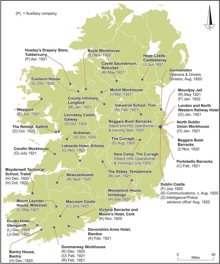
Contents
                                          PART 1

Source 1.    MAP: Location of RIC barracks in Ireland in January 1919, and RIC   p. 4
		           barracks closed by January 1921

Source 2. PHOTOGRAPH: RIC Barracks, Brookeborough, County Fermanagh,             p. 5
		early 1900s.
		[Photo: National Library of Ireland, LROY 0992]

Source 3. MAP: Location of RIC barracks in County Cork in January 1919 and       p. 6
		January 1921

Source 4     PHOTOGRAPH: The wrecked RIC barracks located on King Street         p.7
		           (now MacCurtain Street), Cork, following an IRA bomb attack on 1
		           July 1920
             [Source: © Irish Examiner]

Source 5 MAP: Sites in Dublin associated with Michael Collins during the War     p. 8
		of Independence
.

Source 6     MAP: Map showing the locations of the companies of the Auxiliary    p. 9
		           Division of the RIC (ADRIC), with the dates of their arrival

                                                                                 p.10
Source 7     MAP: Structure and Organisation of the IRA, 1919-21

Source 8     MAP: IRA Volunteers serving in active service units, July 1921      p. 11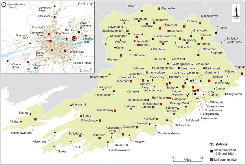
Source 9    MAP: IRA Volunteers as a percentage of the total male population.     p. 12

Source 10   MAP: Cumann na mBan branch membership, 11 July 1921                   p. 13

Source 11   MAP: Map showing amounts raised in each US state by the American
                                                                                  p. 14
		          Committee for Relief in Ireland fundraising drive launched on St
		          Patrick’s Day 1921.
                                                                                  p. 15
Source Background and Captions
Atlas of the Irish Revolution Resources for Schools p. 4 Caption
Atlas of the Irish Revolution Resources for Schools p. 5 Caption
Atlas of the Irish Revolution Resources for Schools p. 6 Caption
Atlas of the Irish Revolution Resources for Schools p. 7 Caption
Atlas of the Irish Revolution Resources for Schools p. 8 Caption
Atlas of the Irish Revolution Resources for Schools p. 9 Caption
Atlas of the Irish Revolution Resources for Schools p. 10 Caption
Atlas of the Irish Revolution Resources for Schools p. 11 Caption
Atlas of the Irish Revolution Resources for Schools p. 12 Caption
Atlas of the Irish Revolution Resources for Schools p. 13 Caption
Atlas of the Irish Revolution Resources for Schools p. 14 Caption
Context and Captions
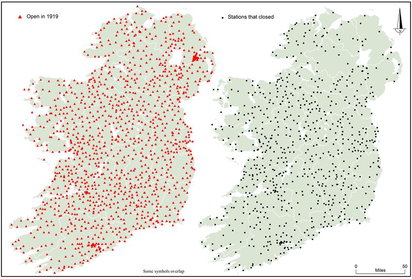
Source 1. MAP: Location of RIC barracks in Ireland in January 1919, and RIC
barracks closed by January 1921
A ‘social war’ of boycotting against the RIC was initiated by republicans in 1917, and was
a crucial factor in preparing the ground for the actual war that was waged in earnest
against the force from early 1920. The boycott/ostracisation policy – confirmed by the Dáil
on 10 April 1919, during which its president, Éamon de Valera, declared the police to be
‘spies in our midst … the eyes and ears of the enemy’ (Dáil Debates, vol. F, no. 6, col. 67)
– succeeded in driving a wedge between the RIC and the community. In the second half
of 1919, sporadic, unsuccessful attacks on barracks began, and the first isolated stations
and temporary ‘huts’ began to close in Clare, Galway and Limerick as early as August
1919. In November of that year the RIC inspector general ordered the closure of the most
vulnerable barracks. Serious attacks began in January 1920 on the initiative of the Cork
IRA. the first semi-fortified barracks, at Carrigtwohill in east Cork, was taken by the IRA
in that month. This coincided with a failed attack on Kilmurry Barracks, west of Cork city,
which signalled the beginning of a countrywide offensive that peaked in the summer of
1920. Following the successful attack against Ballytrain Barracks, County Monaghan in
February 1920, the RIC immediately abandoned six smaller stations across the county,
and by January 1921 had closed twelve of the nineteen in Monaghan, a pattern replicated
in most other counties. Even an unsuccessful attack had the desired results for the IRA;
following the failed attempt to take the Allihies Barracks in west Cork, for example, it and
most of the other small barracks on the Beara Peninsula were abandoned. As elsewhere
in the country, the RIC was then concentrated in more-substantial stations (in this case,
Castletownbere and Bantry), which were heavily fortified and often had additional military
defences. From mid-1920s barrack attacks became far more difficult and less frequent,
but they had served their purpose in both strategic and psychological terms. More than
half of the RIC barracks across the country – over 700 of the approximately 1,300 open
in January 1919 – were closed by January 1921, graphically illustrating the shrinkage of
British authority and control.
[Source: National Archives, UK, RIC Returns by County, 1919 and 1921, HO 184/61. See M. Hopkinson, The Irish War of
Independence (Dublin, 2004 edn), pp. 71–2, and C. Townshend, The Republic: the fight for Irish independence (London, 2013),
pp. 108–9, 114–16)]
Source 2. PHOTOGRAPH: RIC Barracks, Brookeborough, County Fermanagh, early
1900s
The RIC began life in 1822 as a provincially based constabulary; it became the county-
based Irish Constabulary in 1836, and was renamed the Royal Irish Constabulary following
the Fenian Rising in 1867. It embedded itself in the Irish landscape, with barracks being
built in towns and villages across the country. The civic police forces of Belfast and Derry
were absorbed into the RIC by 1870, but the unarmed Dublin Metropolitan Police remained
in place until 1925. On the eve of the First World War there were over 1,400 RIC barracks
spread across Ireland. An armed paramilitary force, the RIC formed an integral part of the
Atlas of the Irish Revolution Resources for Schools p. 15British administration, and by the early 1900s served as an exemplar for colonial police
forces in the British Empire. While its senior officers were disproportionately Protestant, the
majority of its rank-and-file constables were Catholics. Joining the force not only provided
stable employment but also conferred status and respectability, until the sea change
heralded by the War of Independence. In addition to normal duties of maintaining law
and order, RIC members performed a range of bureaucratic tasks, including the gathering
of information on the spread of potato blight (see notice on the barrack wall) and animal
diseases. In effect the RIC was the eyes and ears of an increasingly centralised British
administration and the first line of defence against any challenge to its authority.
Source 3. MAP: Location of RIC barracks in County Cork in January 1919 and January
1921
Location of RIC barracks in County Cork in January 1919 and January 1921. Cork had the
largest number of barracks in the country in January 1919, with 123 in total; the majority
(87) were in the east-riding region, including eleven in the city. The countrywide IRA of-
fensive against the RIC began in Cork in January 1920 when the semi-fortified barracks at
Carrigtwohill in the east of the county was taken by the IRA, followed by a failed attack on
Kilmurry Barracks in the west. By January 1921 eighty barracks (65 per cent of the total in
1919) had been abandoned, including six of the eleven in the city (King Street, St Lukes,
Lower Glanmire Road, Blackrock Road, Sunday’s Well and Blackpool). Others in the vicinity
of the city that were attacked and closed in 1920 were those at Commons Road and Togher.
The policemen were reassigned to the remaining barracks at Union Quay, Tuckey Street,
Cornmarket Street, College Road and Shandon Street. A new station opened on Empress
Place as the headquarters of the Auxiliaries. Nineteen of the thirty-six barracks in west
Cork had closed by January 1921, leaving mainly only those in the larger towns and villages
with heavily supplemented numbers (e.g. Rosscarbery increased from six to twenty-one;
Millstreet: seven to twenty-one; Bandon: twenty-five to forty-six; Skibbereen: fifteen to
twenty-nine), a pattern replicated in east Cork and across the country.
[Source: National Archives, UK, RIC Returns by County, 1919 and 1921, HO 184/61]
Source 4. PHOTOGRAPH: The wrecked RIC barracks located on King Street (now Mac
Curtain Street), Cork, following an IRA bomb attack on 1 July 1920
This station was located in the heart of Cork city, only a half-mile from the British army
headquarters for Munster. Within the Cork city IRA, the King Street Barracks held special
importance, as some of its constables had participated in the assassination of Cork No. 1
Brigade commander and Cork lord mayor, Tomás Mac- Curtain, in March 1920. IRA Volun-
teers placed a bomb in a building adjoining the barracks, while teams of gunmen cleared
the street of pedestrians. An intended IRA storming of the barracks was foiled by a prema-
ture exchange of fire with a constable. However, the bomb blast wrecked the barracks and
compelled its evacuation. It was then burned down by the IRA on 12 July, along with other
abandoned barracks at St Luke’s and Lower Glanmire Road. King Street was one of six of
the eleven stations in the Cork city RIC district to be evacuated between January 1919 and
January 1921.
[Source: © Irish Examiner]
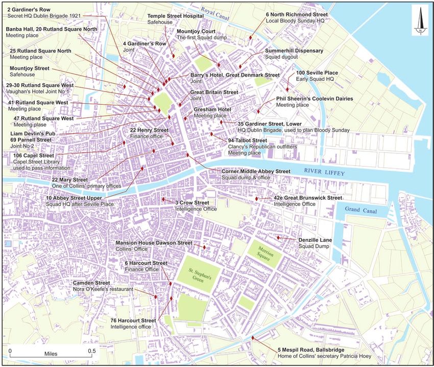
Atlas of the Irish Revolution Resources for Schools p. 16Source 5. MAP: Sites in Dublin associated with Michael Collins during the War of
Independence
Collins was the key organiser of the independence movement, holding the two key
positions of IRA director of intelligence and Dáil Éireann secretary for finance. In Dublin
he maintained numerous offices, safe houses and meeting places, many of them clustered
around Parnell Square in the north inner city. Some of his administrative centres were
disguised as commercial offices, and Collins usually moved about well dressed, resembling
a clerk or businessman. He also relied on seemingly innocuous hotels, pubs and shops
run by republican sympathisers. The identifiers of the locations come from contemporary
language and denote slang of the period, such as ‘joint’ (a hotel or public house where Collins
met colleagues, spies, messengers, etc.), ‘dump’ (a place where arms and ammunitions were
stored) and ‘dugout’ (a place where Squad members ‘holed up’ while on the run or waiting
for action). This map also features some locations associated with Collins’ ‘Squad’, a group
of IRA intelligence operatives who specialised in assassination, such as the ‘Bloody Sunday’
operation in November 1920.
[Map compiled by Charles Roche using multiple sources]
Source 6
MAP: Map showing the locations of the companies of the Auxiliary
Division of the RIC (ADRIC), with the dates of their arrival at the
location
The Depot Company was based originally at the Curragh, but moved to Beggar’s Bush
Barracks in Dublin in September 1920. A Veterans & Drivers Division numbering 856, based
at Gormanstown, provided the drivers for ADRIC, while two companies, ‘S’ and ‘Z’, involved
in intelligence and communications work, were based at Dublin Castle. Seventeen field
companies (‘A’ to ‘R’) were based at different times across seventeen counties.
[Sources: Information supplied by Jim Herlihy; E. McCall, The Auxiliaries: Tudor’s Toughs (Newtownards, 2010); D.M. Leeson,
The Black and Tans: British police and auxiliaries in the Irish War of Independence, 1920–1921 (Oxford, 2011); http://www.
theauxiliaries. com [accessed 1 Feb. 2016]; contemporary newspaper reports, 1920–21]
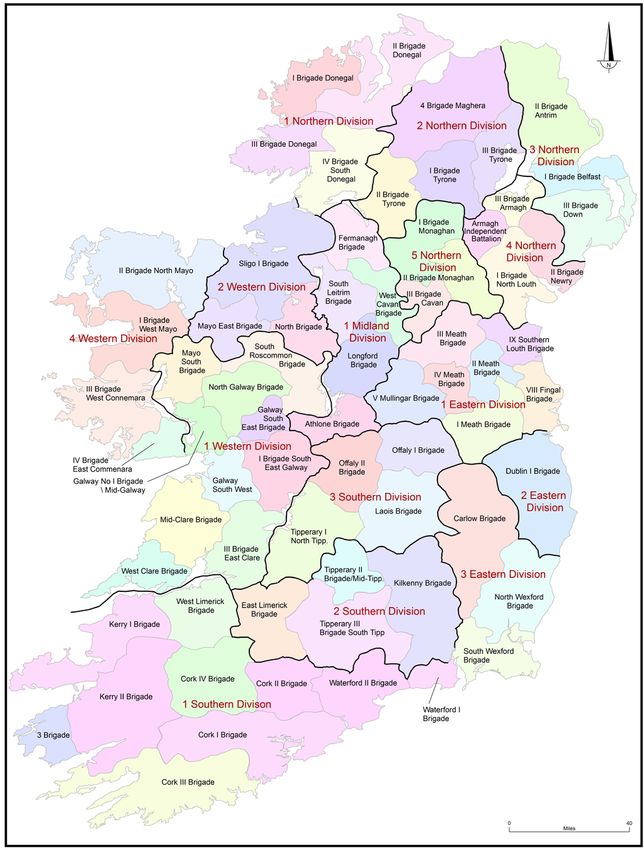
Source 7. MAP: Structure and Organisation of the IRA, 1919-21
Despite a lack of weapons and other material sources, the IRA built a sophisticated guerrilla
army based on a parish-by-parish organisation. A town, rural area or urban neighbourhood/
community formed a company; a number of companies comprised a battalion (usually a
district, parliamentary constituency or barony); a number of battalions formed a brigade
(typically a large part of a county). Late in the War of Independence and during the Truce
period, brigades were organised into divisions. Overall, the IRA fielded a total of sixty-five
brigades and 297 battalions, with a paper strength of 115,550 Volunteers. Many Volunteers
were nominal and not all units functioned adequately by the Truce of 1921. Yet the IRA’s
insurgency continued to grow despite severe pressure from the Crown forces. This sustained
republican resistance depended on the service of tens of thousands of ordinary Volunteers,
who remained engaged and highly committed throughout the conflict.
[Source: Irish Military Archives, Military Service Pensions Collection, IRA Nominal Rolls, RO/1-611]
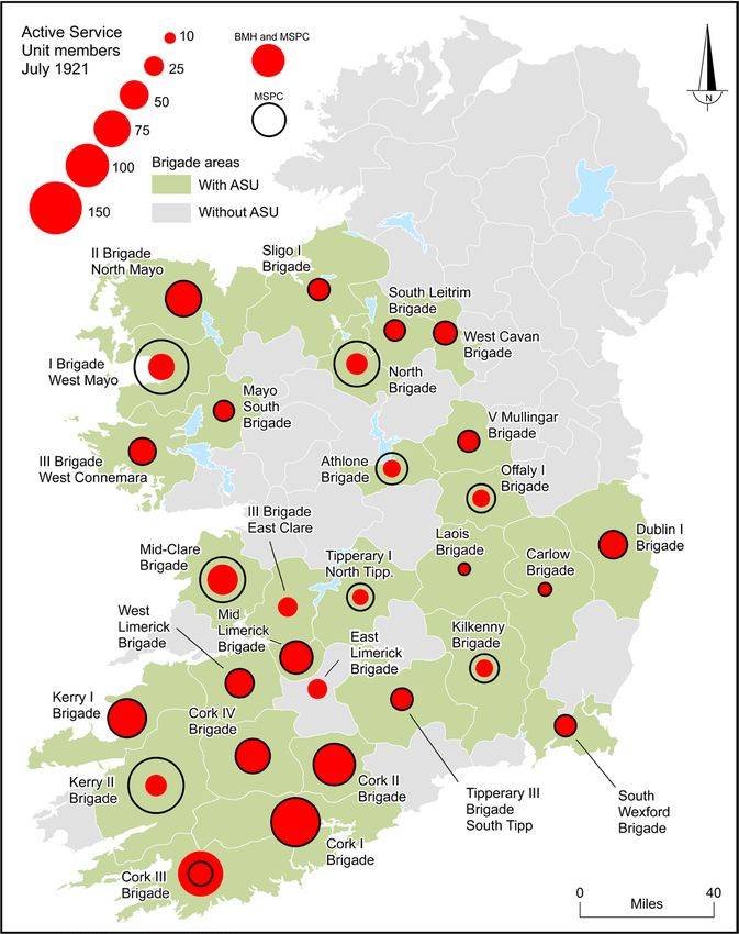
Atlas of the Irish Revolution Resources for Schools p. 17Source 8. MAP: IRA Volunteers serving in active service units, July 1921
While IRA flying columns retain their own special place within the popular memory of
the Irish War of Independence, there were relatively few of them operating at the time of
the Truce of July 1921. This map shows the number of Volunteers serving in various flying
columns and active service units (the terms mean the same thing), which can be defined
as armed units comprised of full-time members. Their numeric strength usually correlated
with the number of rifles available in their unit area. Columns often disbanded periodically
and then reformed, giving them an elastic membership, with different Volunteers serving
in them at different times. Some brigades fielded numerous columns, such as Cork No. 1
Brigade, which operated seven different columns in its most active battalion areas. This
map is based primarily on brigade submissions to the Military Service Pensions Collection
(MSPC), and details the number of IRA Volunteers who were on ‘active service’ at the time
of the 1921 Truce. These figures do not always tally with flying-column strengths provided
in the Bureau of Military History (BMH) witness statements. In units with discrepancies,
figures from both the MSPC and BMH have been provided. The MSPC appears to have
missed some columns entirely, such as two columns operated by the Longford Brigade
(north Longford, twenty-three Volunteers; and south Longford, thirteen Volunteers). Overall,
the map illustrates the small number of full-time armed guerrilla fighters facing the Crown
forces in Ireland, and the concentration of column units in south and western Munster and
parts of Connacht.
[Source: Irish Military Archives, Military Service Pensions Collection, IRA Nominal Rolls, RO/1-611]
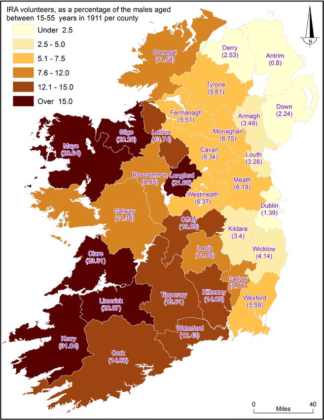
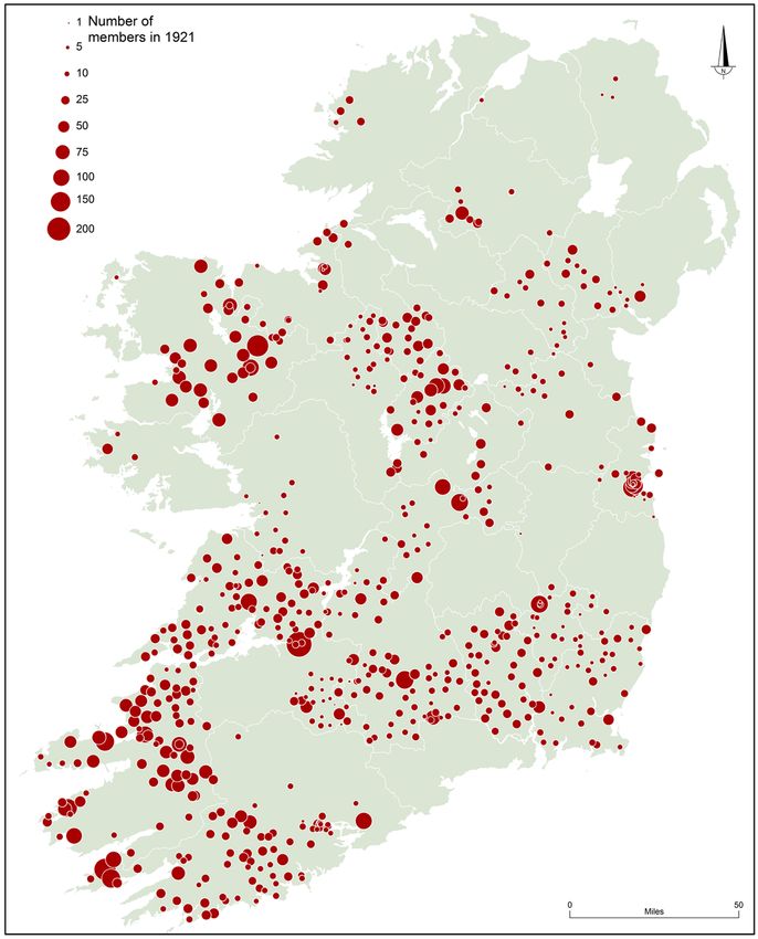
Source 9. MAP: IRA Volunteers as a percentage of the total male population
The density of IRA membership reflects successful mobilisation of young men for resistance
to British governance in Ireland. Using the 1911 census and IRA membership figures at the
time of the 1921 Truce (found in the Military Service Pensions Collection in the Military
Archives, Dublin), this map shows the ratio of IRA Volunteers per head of population in each
county. The province of Munster leads the way in IRA membership percentages. County
Kerry’s remarkable figure of 8.13 per cent is far and away the highest in Ireland. Following
directly behind are Clare (6.35 per cent) and Limerick and Longford (both at 5.85 per cent).
Counties Cork (4.21 per cent) and Tipperary (3.98 per cent) come in at seventh and ninth
respectively. Connacht, with its strong counties of Sligo and Mayo, only managed in part
to match the mobilisation of young men by the well-organised units of the Munster IRA.
[Source: Irish Military Archives, MSPC, RO/1-611]
Source 10. MAP: Cumann na mBan branch membership, 11 July 1921
Cumann na mBan was a mass movement of republican women that encompassed much
of the island. This map comes from Military Service Pensions Collection submissions that
detail 17,119 members attached to 750 branches across Ireland at the time of the 1921
Truce. Collected in 1936–37, this data is not comprehensive. Numerous district councils
apparently did not submit their details (for example, west Limerick, north Cork and
Waterford), while some branch lists compiled fifteen years after the conflict likely omitted
Atlas of the Irish Revolution Resources for Schools p. 18certain members. However, despite these weaknesses the collected data illuminates the
inner workings of the female republican organisation. Cumann na mBan broadly mirrors
IRA membership density; high mobilisation is visible in south-west Munster and parts of
Connacht, compared with low returns in areas of the midlands and Ulster. Economically
disadvantaged parts of the west seem to have organised fewer women, which might reflect
financial barriers caused by Cumann na mBan’s weekly dues and the cost of uniforms.
Organisationally, while Cumann na mBan branches and district councils largely matched
IRA company and battalion structures, it did not include the IRA’s brigade level. This created
a flat structure lacking a regional command level, which may have hindered optimum
mobilisation, as seen in the case of north-west County Kerry. Here, Cumann na mBan
formed a brigade structure (attached to the IRA’s Kerry No. 1 Brigade), which seemed
to have helped develop a vibrant organisation. Branches in that part of Kerry account
for roughly 2,000 Cumann na mBan members, roughly 12 per cent of the organisation’s
listed national strength. Overall, the map indicates an uneven national organisation that
mobilised women in cities, towns and villages across urban and rural Ireland, with varying
levels of success.
[Source: Irish Military Archives, Military Service Pensions Collection, Cumann na mBan Nominal Rolls, CNB 1/165]
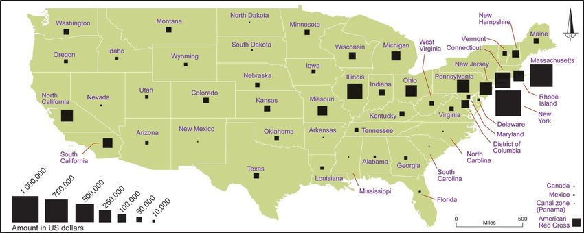
Source 11. MAP: Map showing amounts raised in each US state by the American
Committee for Relief in Ireland fundraising drive launched on St Patrick’s
Day 1921
An ambitious target of $10 million had been set, and each state was given a quota.
Connecticut (358.51 per cent), Rhode Island (315.88 per cent) and New Hampshire (211.9
per cent) far exceeded their targets, but other states, such as New Mexico (2.03 per cent),
South Carolina (6.02 per cent), Pennsylvania (14.05 per cent), Indiana (16.6 per cent), North
Carolina (20.22 per cent), New York State (24.13 per cent) and Oklahoma (25.89 per cent),
fell far short. New York City raised the largest amount: just under its target of $1 million.
Massachusetts, with its large Irish community, had been given the largest quota of $1.5
million, but it only raised 49 per cent of that, which was still the second-highest in the
country. In total $5,223,496 (c. £1.3m) was raised for disbursement through the Irish White
Cross.
[Source: Reports of American Committee for Relief in Ireland and Irish White Cross (New York, 1922)]
Atlas of the Irish Revolution Resources for Schools p. 19You can also read