DroNet: Learning to Fly by Driving - Antonio Loquercio , Ana I. Maqueda , Carlos R. del-Blanco , and Davide Scaramuzza - Robotics and ...
←
→
Page content transcription
If your browser does not render page correctly, please read the page content below
IEEE ROBOTICS AND AUTOMATION LETTERS. PREPRINT VERSION. ACCEPTED JANUARY, 2018                                                                 1

                       DroNet: Learning to Fly by Driving
               Antonio Loquercio∗ , Ana I. Maqueda † , Carlos R. del-Blanco † , and Davide Scaramuzza∗

   Abstract—Civilian drones are soon expected to be used in a
wide variety of tasks, such as aerial surveillance, delivery, or
monitoring of existing architectures. Nevertheless, their deploy-
ment in urban environments has so far been limited. Indeed,
in unstructured and highly dynamic scenarios, drones face
numerous challenges to navigate autonomously in a feasible and
safe way. In contrast to traditional “map-localize-plan” methods,
this paper explores a data-driven approach to cope with the
above challenges. To accomplish this, we propose DroNet: a
convolutional neural network that can safely drive a drone
through the streets of a city. Designed as a fast 8-layers residual
network, DroNet produces two outputs for each single input
image: a steering angle to keep the drone navigating while
avoiding obstacles, and a collision probability to let the UAV
recognize dangerous situations and promptly react to them. The
challenge is however to collect enough data in an unstructured
outdoor environment such as a city. Clearly, having an expert                 Fig. 1: DroNet is a convolutional neural network, whose
pilot providing training trajectories is not an option given the              purpose is to reliably drive an autonomous drone through
large amount of data required and, above all, the risk that it
                                                                              the streets of a city. Trained with data collected by cars and
involves for other vehicles or pedestrians moving in the streets.
Therefore, we propose to train a UAV from data collected by                   bicycles, our system learns from them to follow basic traffic
cars and bicycles, which, already integrated into the urban                   rules, e.g, do not go off the road, and to safely avoid other
environment, would not endanger other vehicles and pedestrians.               pedestrians or obstacles. Surprisingly, the policy learned by
Although trained on city streets from the viewpoint of urban                  DroNet is highly generalizable, and even allows to fly a drone
vehicles, the navigation policy learned by DroNet is highly
                                                                              in indoor corridors and parking lots.
generalizable. Indeed, it allows a UAV to successfully fly at
relative high altitudes and even in indoor environments, such
as parking lots and corridors. To share our findings with the
robotics community, we publicly release all our datasets, code,               robotic system facing the above tasks should simultaneously
and trained networks.
                                                                              solve many challenges in perception, control, and localization.
  Index Terms—Learning from Demonstration, Deep Learning                      These become particularly difficult when working in urban
in Robotics and Automation, Aerial Systems: Perception and
                                                                              areas, as the one illustrated in Fig. 1. In those cases, the
Autonomy
                                                                              autonomous agent is not only expected to navigate while
                                                                              avoiding collisions, but also to safely interact with other agents
                   S UPPLEMENTARY M ATERIAL                                   present in the environment, such as pedestrians or cars.
   For supplementary video see:https://youtu.be/ow7aw9H4BcA.                     The traditional approach to tackle this problem is a two step
The project’s code, datasets and trained models are available at:             interleaved process consisting of (i) automatic localization in
http://rpg.ifi.uzh.ch/dronet.html.                                            a given map (using GPS, visual and/or range sensors), and
                                                                              (ii) computation of control commands to allow the agent to
                         I. I NTRODUCTION                                     avoid obstacles while achieving its goal [1], [4]. Even though
    AFE and reliable outdoor navigation of autonomous sys-                    advanced SLAM algorithms enable localization under a wide
S   tems, e.g. unmanned aerial vehicles (UAVs), is a chal-
lenging open problem in robotics. Being able to successfully
                                                                              range of conditions [5], visual aliasing, dynamic scenes, and
                                                                              strong appearance changes can drive the perception system
navigate while avoiding obstacles is indeed crucial to un-                    to unrecoverable errors. Moreover, keeping the perception
lock many robotics applications, e.g. surveillance, construction              and control blocks separated not only hinders any possibility
monitoring, delivery, and emergency response [1], [2], [3]. A                 of positive feedback between them, but also introduces the
                                                                              challenging problem of inferring control commands from 3D
  Manuscript received: September, 10, 2017; Revised December, 7, 2017;
Accepted January, 2, 2018.
                                                                              maps.
  This paper was recommended for publication by Editor Dongheui Lee upon         Recently, new approaches based on deep learning have of-
evaluation of the Associate Editor and Reviewers’ comments.                   fered a way to tightly couple perception and control, achieving
  ∗ The authors are with the Robotics and Perception Group, Dep. of Infor-
matics University of Zurich and Dep. of Neuroinformatics of the University    impressive results in a large set of tasks [6], [7], [8]. Among
of Zurich and ETH Zurich, Switzerland—http://rpg.ifi.uzh.ch.                  them, methods based on reinforcement learning (RL) suffer
  † The authors are with the Grupo de Tratamiento de Imágenes, Information
                                                                              from significantly high sample complexity, hindering their
Processing and Telecommunications Center and ETSI Telecomunicación,
Universidad Politécnica de Madrid, Spain—http://gti.ssr.upm.es.              application to UAVs operating in safety-critical environments.
  Digital Object Identifier (DOI): see top of this page.                      In contrast, supervised-learning methods offer a more viable
2                                                   IEEE ROBOTICS AND AUTOMATION LETTERS. PREPRINT VERSION. ACCEPTED JANUARY, 2018

way to learn effective flying policies [6], [9], [10], but they     is not entirely clear how to infer control commands for a safe
still leave the issue of collecting enough expert trajectories to   and reliable flight from it.
imitate. Additionally, as pointed out by [10], collision trajec-       Recently, there has been an increasing research effort in
tories avoided by expert human pilots are actually necessary        directly learning control policies from raw sensory data using
to let the robotic platform learn how to behave in dangerous        Deep Neural Networks. These methodologies can be divided
situations.                                                         into two main categories: (i) methods based on reinforcement
                                                                    learning (RL) [7], [11] and (ii) methods based on supervised
Contributions                                                       learning [6], [12], [9], [10], [13].
   Clearly, a UAV successfully navigating through the streets          While RL-based algorithms have been successful in learning
should be able to follow the roadway as well as promptly            generalizing policies [7], [8], they usually require a large
react to dangerous situations exactly as any other ground           amount of robot experience which is costly and dangerous to
vehicle would do. Therefore, we herein propose to use data          acquire in real safety-critical systems. In contrast, supervised
collected from ground vehicles which are already integrated         learning offers a more viable way to train control policies, but
in environments as aforementioned. Overall, this work makes         clearly depends upon the provided expert signal to imitate.
the following contributions:                                        This supervision may come from a human expert [6], hard-
                                                                    coded trajectories [10], or model predictive control [12].
   • We propose a residual convolutional architecture which,
                                                                    However, when working in the streets of a city, it can be
     by predicting the steering angle and the collision proba-
                                                                    both tedious and dangerous to collect a large set of expert
     bility, can perform a safe flight of a quadrotor in urban
                                                                    trajectories, or evaluate partially trained policies [6]. Addition-
     environments. To train it, we employ an outdoor dataset
                                                                    ally, the domain-shift between expert and agent might hinder
     recorded from cars and bicycles.
                                                                    generalization capabilities of supervised learning methods.
   • We collect a custom dataset of outdoor collision se-
                                                                    Indeed, previous work in [9], [13] trained a UAV from video
     quences to let a UAV predict potentially dangerous situ-
                                                                    collected by a mountain hiker but did not show the learned
     ations.
                                                                    policy to generalize to scenarios unseen at training time.
   • Trading off performance for processing time, we show
                                                                    Another promising approach has been use simulations to get
     that our design represents a good fit for navigation-related
                                                                    training data for reinforcement or imitation learning tasks,
     tasks. Indeed, it enables real-time processing of the video
                                                                    while testing the learned policy in the real world [14], [15],
     stream recorded by a UAV’s camera.
                                                                    [11]. Clearly, this approach suffers from the domain shift
   • Through an extensive evaluation, we show that our system
                                                                    between simulation and reality and might require some real-
     can be applied to new application spaces without any
                                                                    world data to be able to generalize [11]. To our knowledge,
     initial knowledge about them. Indeed, with neither a
                                                                    current simulators still fail to model the large amount of
     map of the environment nor retraining or fine-tuning,
                                                                    variability present in an urban scenario and are therefore not
     our method generalizes to scenarios completely unseen
                                                                    fully acceptable for our task. Additionally, even though some
     at training time including indoor corridors, parking lots,
                                                                    pioneering work has been done in [14], it is still not entirely
     and high altitudes.
                                                                    clear how to make policies learned in simulation generalize
   Even though our system achieves remarkable results, we do        into the real world.
not aim to replace traditional “map-localize-plan” approaches          To overcome the above-mentioned limitations, we propose
for drone navigation, but rather investigate whether a similar      to train a neural network policy by imitating expert behaviour
task could be done with a single shallow neural network.            which is generated from wheeled manned vehicles only. Even
Indeed, we believe that learning-based and traditional ap-          though there is a significant body of literature on the task of
proaches will one day complement each other.                        steering angle prediction for ground vehicles [16], [17], our
                                                                    goal is not to propose yet another method for steering angle
                     II. R ELATED WORK                              prediction, but rather to prove that we can deploy this expertise
   A wide variety of techniques for drone navigation and            also on flying platforms. The result is a single shallow network
obstacle avoidance can be found in the literature. At high level,   that processes all visual information concurrently, and directly
these methods differ depending on the kind of sensory input         produces control commands for a flying drone. The coupling
and processing employed to control the flying platform.             between perception and control, learned end-to-end, provides
   A UAV operating outdoor is usually provided with GPS,            several advantages, such as a simpler and lightweight system
range, and visual sensors to estimate the system state, infer       and high generalization abilities. Additionally, our data collec-
the presence of obstacles, and perform path planning [1],           tion proposal does not require any state estimate or even an
[4]. Nevertheless, such works are still prone to fail in urban      expert drone pilot, while it exposes pedestrians, other vehicles,
environments where the presence of high rise buildings, and         and the drone itself to no danger.
dynamic obstacles can result in significant undetected errors
in the system state estimate. The prevalent approach in such
                                                                                         III. M ETHODOLOGY
scenarios is SLAM, where the robot simultaneously builds a
map of the environment and self-localizes in it [5]. On the            Our learning approach aims at reactively predicting a
other hand, while an explicit 3D reconstruction of the envi-        steering angle and a probability of collision from the drone
ronment can be good for global localization and navigation, it      on-board forward-looking camera. These are later converted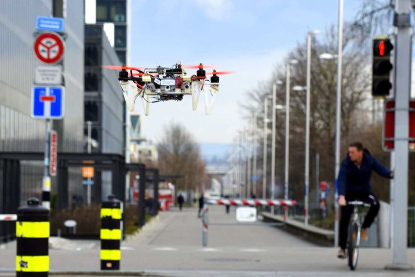
LOQUERCIO et al.: DRONET: LEARNING TO FLY BY DRIVING                                                                                 3

into control flying commands which enable a UAV to safely            or constant loss weight between the two losses would likely
navigate while avoiding obstacles.                                   result in sub-optimal performance or require much longer
   Since we aim to reduce the bare image processing time, we         optimization times. This can be seen as a particular form
advocate a single convolutional neural network (CNN) with            of curriculum learning [19]. In detail, the weight coefficient
a relatively small size. The resulting network, which we call        corresponding to BCE is defined in (1), while the one for
                                                                                                                                 1
DroNet, is shown in Fig. 2 (a). The architecture is partially        MSE is always 1. For our experiments, we set decay = 10       ,
shared by the two tasks to reduce the network’s complexity and       and epoch0 = 10.
processing time, but is then separated into two branches at the
very end. Steering prediction is a regression problem, while
                                                                       Ltot = LMSE + max(0, 1 − exp−decay(epoch−epoch0 ) )LBCE    (1)
collision prediction is addressed as a binary classification
problem. Due to their different nature and output range, we             The Adam optimizer [20] is used with a starting learning
propose to separate the network’s last fully-connected layer.        rate of 0.001 and an exponential per-step decay equal to 10−5 .
   During the training procedure, we use only imagery                We also employ hard negative mining for the optimization to
recorded by manned vehicles. Steering angles are learned from        focus on those samples which are the most difficult to learn.
images captured from a car, while probability of collision,          In particular, we select the k samples with the highest loss in
from a bicycle.                                                      each epoch, and compute the total loss according to Eq. (1).
                                                                     We define k so that it decreases over time.
A. Learning Approach                                                 B. Datasets
   The part of the network that is shared by the two tasks              To learn steering angles from images, we use one of the
consists of a ResNet-8 architecture followed by a dropout            publicly available datasets from Udacity’s project [21]. This
of 0.5 and a ReLU non-linearity. The residual blocks of the          dataset contains over 70, 000 images of car driving distributed
ResNet, proposed by He et al. [18], are shown in Fig. 2 (b).         over 6 experiments, 5 for training and 1 for testing. Every
Dotted lines represent skip connections defined as 1×1 convo-        experiment stores time-stamped images from 3 cameras (left,
lutional shortcuts to allow the input and output of the residual     central, right), IMU, GPS data, gear, brake, throttle, steering
blocks to be added. Even though an advantage of ResNets              angles and speed. For our experiment, we only use images
is to tackle the vanishing/exploding gradient problems in very       from the forward-looking camera (Fig. 3 (a)) and their asso-
deep networks, its success lies in its learning principle. Indeed,   ciated steering angles.
the residual scheme has been primarily introduced to address            To our knowledge, there are no public datasets that associate
the degradation problem generated by difficulties in networks’       images with collision probability according to the distance to
optimization [18]. Therefore, since residual architectures are       the obstacles. Therefore, we collect our own collision data
known to help generalization on both shallow and deep net-           by mounting a GoPro camera on the handlebars of a bicycle.
works [18], we adapted this design choice to increase model          We drive along different areas of a city, trying to diversify
performance. After the last ReLU layer, tasks stop sharing           the types of obstacles (vehicles, pedestrians, vegetation, under-
parameters, and the architecture splits into two different fully-    construction sites) and the appearance of the environment (Fig.
connected layers. The first one outputs the steering angle, and      3 (b)). This way, the drone is able to generalize under different
the second one a collision probability. Strictly speaking the        scenarios. We start recording when we are far away from an
latter is not a Bayesian probability but an index quantifying        obstacle and stop when we are very close to it. In total, we
the network uncertainty in prediction. Slightly abusing the          collect around 32,000 images distributed over 137 sequences
notation, we still refer to it as “probability”.                     for a diverse set of obstacles. We manually annotate the
   We use mean-squared error (MSE) and binary cross-entropy          sequences, so that frames far away from collision are labeled
(BCE) to train the steering and collision predictions, re-           as 0 (no collision), and frames very close to the obstacle are
spectively. Although the network architecture proves to be           labeled as 1 (collision), as can be seen in Fig. 3(b). Collision
appropriate to minimize complexity and processing time, a            frames are the types of data that cannot be easily obtained by
naive joint optimization poses serious convergence problems          a drone but are necessary to build a safe and robust system.
due to the very different gradients’ magnitudes that each loss
produces. More specifically, imposing no weighting between           C. Drone Control
the two losses during training results in convergence to a
                                                                        The outputs of DroNet are used to command the UAV to
very poor solution. This can be explained by difference of
                                                                     move on a plane with forward velocity vk and steering angle
gradients’ magnitudes in the classification and regression task
                                                                     θk . More specifically, we use the probability of collision pt
at the initial stages of training, which can be problematic for
                                                                     provided by the network to modulate the forward velocity:
optimization [19]. Indeed, the gradients from the regression
                                                                     the vehicle is commanded to go at maximal speed Vmax when
task are initially much larger, since the MSE gradients’ norms
                                                                     the probability of collision is null, and to stop whenever it is
is proportional to the absolute steering error. Therefore, we
                                                                     close to 1. We use a low-pass filtered version of the modulated
give more and more weight to the classification loss in later
                                                                     forward velocity vk to provide the controller with smooth,
stages of training. Once losses’ magnitudes are comparable,
                                                                     continuous inputs (0 ≤ α ≤ 1):
the optimizer will try to find a good solution for both at
the same time. For the aforementioned reasons, imposing no                         vk = (1 − α)vk−1 + α(1 − pt )Vmax ,            (2)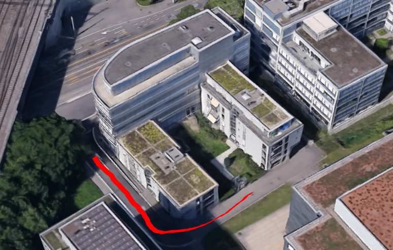
4 IEEE ROBOTICS AND AUTOMATION LETTERS. PREPRINT VERSION. ACCEPTED JANUARY, 2018
Fig. 2: (a) DroNet is a forked Convolutional Neural Network that predicts, from a single 200 × 200 frame in gray-scale, a
steering angle and a collision probability. The shared part of the architecture consists of a ResNet-8 with 3 residual blocks (b),
followed by dropout and ReLU non-linearity. Afterwards, the network branches into 2 separated fully-connected layers, one
to carry out steering prediction, and the other one to infer collision probability. In the notation above, we indicate for each
convolution first the kernel’s size, then the number of filters, and eventually the stride if it is different from 1.
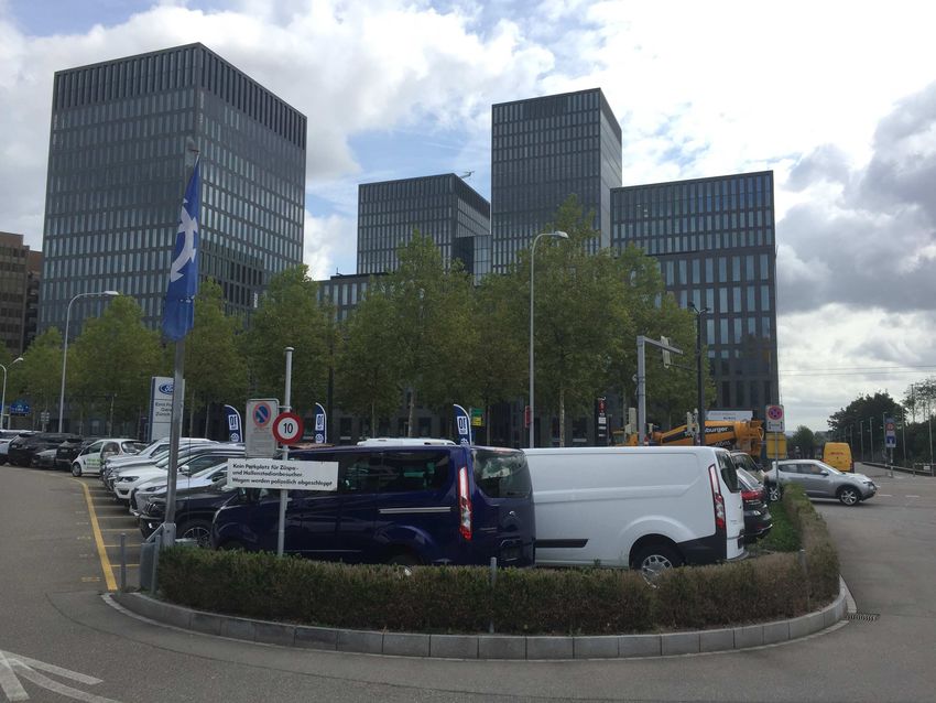
Fig. 3: (a) Udacity images used to learn steering angles. (b) Collected images to learn probability of collision. The green box
contains no-collision frames, and the red one collision frames.
Similarly, we map the predicted scaled steering sk into a IV. E XPERIMENTAL R ESULTS
rotation around the body z-axis (yaw angle θ ), corresponding In this section, we show quantitative and qualitative results
to the axis orthogonal to the propellers’ plane. Concretely, we of our proposed methodology. First, we evaluate the accuracy
convert sk from a [−1, 1] range into a desired yaw angle θk in of DroNet with a set of performance metrics. Then, we discuss
the range [− π2 , π2 ] and low-pass filter it: its control capabilities comparing it against a set of navigation
π baselines.
θk = (1 − β )θk−1 + β sk (3)
2
In all our experiments we set α = 0.7 and β = 0.5, while A. Hardware Specification
Vmax was changed according to the testing environment. The We performed our experiments on a Parrot Bebop 2.0 drone.
above constants have been selected empirically trading off Designed as an outdoor hobby platform, it has a basic and
smoothness for reactiveness of the drone’s flight. As a result, rather inaccurate, visual odometry system that allows the user
we obtain a reactive navigation policy that can reliably control to provide only high-level commands, such as body-frame
a drone from a single forward-looking camera. An interesting velocities, to control the platform. Velocity commands are
aspect of our approach is that we can produce a collision produced by our network running on an Intel Core i7 2.6 GHz
probability from a single image without any information about CPU that receives images at 30 Hz from the drone through
the platform’s speed. Indeed, we conjecture the network to Wi-Fi.
make decision on the base of the distance to observed objects
in the field of view. Convolutional networks are in fact well
known to be successful on the task of monocular depth B. Regression and Classification Results
estimation [15]. An interesting question that we would like We first evaluate the regression performance of our model
to answer in future work is how this approach compares to an employing the testing sequence from the Udacity dataset [21].
LSTM [22] based solution, making decisions over a temporal To quantify the performance on steering prediction, we use
horizon. two metrics: root-mean-squared error (RMSE) and explained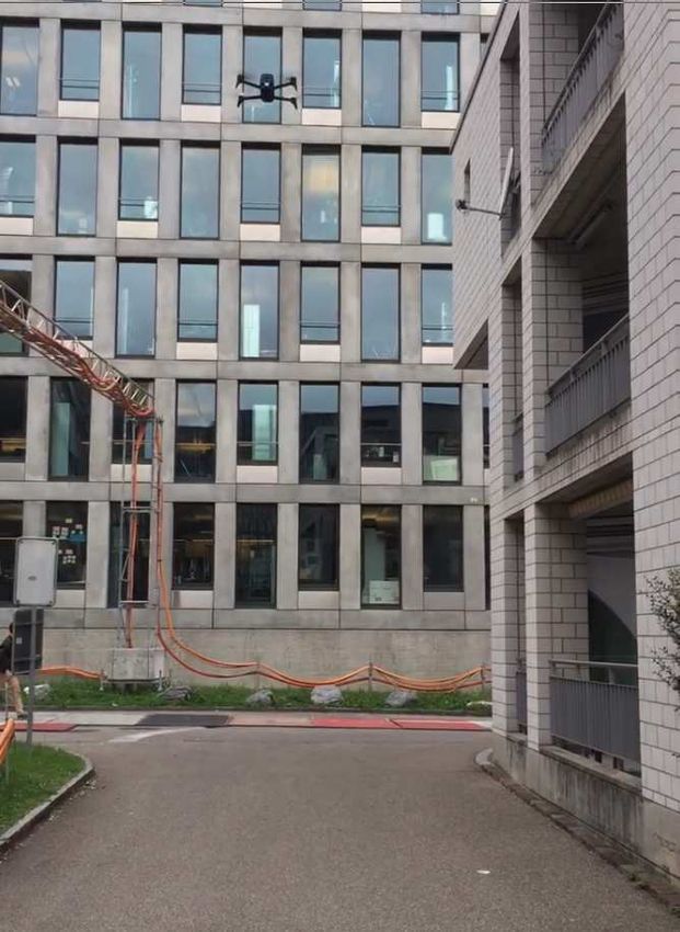
LOQUERCIO et al.: DRONET: LEARNING TO FLY BY DRIVING                                                                                                 5

    Model                     EVA            RMSE          Avg. accuracy      F-1 score    Num. Layers   Num. parameters     Processing time [fps]
    Random baseline        -1.0 ± 0.022    0.3 ± 0.001         50.0 ± 0.1%    0.3 ± 0.01        -                -                     -
    Constant baseline            0            0.2129              75.6%          0.00           -                -                     -
    Giusti et al. [9]          0.672          0.125               91.2%         0.823          6             5.8 × 10⁴                23
    ResNet-50 [18]             0.795          0.097               96.6%         0.921          50            2.6 × 10⁷                 7
    VGG-16 [23]                0.712           0.119              92.7%         0.847          16            7.5 × 10⁶                12
    DroNet (Ours)              0.737          0.109               95.4%         0.901           8            3.2 × 10⁵                20

TABLE I: Quantitative results on regression and classification task: EVA and RMSE are computed on the steering regression task,
while Avg. accuracy and F-1 score are evaluated on the collision prediction task. Our model compares favorably against the considered
baselines. Despite being relatively lightweight in terms of number of parameters, DroNet maintains a very good performance on both tasks.
We additionally report the on-line processing time in frames per second (fps), achieved when receiving images at 30 Hz from the UAV.

                                                                                  in indoor environments. An illustration of the testing environ-
                                                                                  ments can be found in Fig. 5 and Fig. 6. We compare our
                                                                                  approach against two baselines:
                                                                                     (a) Straight line policy: trivial baseline consisting in follow-
                                                                                  ing a straight path in open-loop. This baseline is expected to
                                                                                  be very weak, given that we always tested in environments
                                                                                  with curves.
                                                                                     (b) Minimize probability of collision policy: strong base-
                                                                                  line consisting in going toward the direction minimizing the
                     (a)                                 (b)                      collision probability. For this approach, we implemented the
Fig. 4: Model performance: (a) Probability Density Function (PDF)                 algorithm proposed in [10], which was shown to have very
of actual vs. predicted steerings of the Udacity dataset testing se-              good control capabilities in indoor environments. We employ
quence. (b) Confusion matrix on the collision classification evaluated            the same architecture as in DroNet along with our collected
on testing images of the collected dataset. Numbers in this matrix                dataset in order to estimate the collision probability.
indicate the percentage of samples falling in each category.                         As metric we use the average distance travelling before
variance ratio (EVA)1 . To asses the performance on collision                     stopping or colliding. Results from Table II indicate that
prediction, we use average classification accuracy and the F-1                    DroNet is able to drive a UAV the longest on almost all the
score2 .                                                                          selected testing scenarios. The main strengths of the policy
                                                                                  learned by DroNet are twofold: (i) the platform smoothly
   Table I compares DroNet against a set of other architectures
                                                                                  follows the road lane while avoiding static obstacles; (ii) the
from the literature [18], [23], [9]. Additionally, we use as
                                                                                  drone is never driven into a collision, even in presence of
weak baselines a constant estimator, which always predicts
                                                                                  dynamic obstacles, like pedestrians or bicycles, occasionally
0 as steering angle and “no collision”, and a random one.
                                                                                  occluding its path. Another interesting feature of our method
From these results we can observe that our design, even
                                                                                  is that DroNet usually drives the vehicle to a random direction
though 80 times smaller than the best architecture, maintains a
                                                                                  in open spaces and at intersections. In contrast, the baseline
considerable prediction performance while achieving real-time
                                                                                  policy of minimizing the probability of collision was very of-
operation (20 frames per second). Furthermore, the positive
                                                                                  ten confused by intersections and open spaces, which resulted
comparison against the VGG-16 architecture indicates the
                                                                                  in a shaky uncontrolled behaviour. This explains the usually
advantages in terms of generalization due to the residual
                                                                                  large gaps in performance between our selected methodology
learning scheme, as discussed in Section III-A. Our design
                                                                                  and the considered baselines.
succeeds at finding a good trade-off between performance and
                                                                                     Interestingly, the policy learned by DroNet generalizes well
processing time as shown in Table I and Fig. 4. Indeed, in order
                                                                                  to scenarios visually different from the training ones, as shown
to enable a drone to promptly react to unexpected events or
                                                                                  in Table II. First, we noticed only a very little drop in
dangerous situations, it is necessary to reduce the network’s
                                                                                  performance when the vehicle was flying at relatively high
latency as much as possible.
                                                                                  altitude (5 m). Even though the drone’s viewpoint was different
                                                                                  from a ground vehicle’s one (usually at 1.5 m), the curve
C. Quantitative Results on DroNet’s Control Capabilities                          could be successfully completed as long as the path was in
                                                                                  the field of view of the camera. More surprisingly was the
   We tested our DroNet system by autonomously navigating
                                                                                  generalization of our method to indoor environments such
in a number of different urban trails including straight paths
                                                                                  as a corridor or a parking lot. In these scenarios, the drone
and sharp curves. Moreover, to test the generalization capa-
                                                                                  was still able to avoid static obstacles, follow paths, and stop
bilities of the learned policy, we also performed experiments
                                                                                  in case of dynamic obstacles occluding its way. Nonetheless,
  1 Explained Variance is a metric used to quantify the quality of a regressor,   we experienced some domain-shift problems. In indoor envi-
                           Var[ytrue −y pred ]
and is defined as EVA = Var[y                                                     ronments, we experienced some drifts at intersections which
                                     true ]
  2 F-1 score is a metric used to quantify the quality of a classifier. It is     were sometimes too narrow to be smoothly performed by our
                  precision×recall
defined as F-1= 2 precision+recall                                                algorithm. In contrast, as we expected, the baseline policy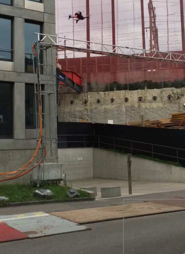
6 IEEE ROBOTICS AND AUTOMATION LETTERS. PREPRINT VERSION. ACCEPTED JANUARY, 2018
(a) Outdoor 1 (b) Outdoor 2 (c) Outdoor 3
(d) Indoor Parking Lot (e) Indoor Corridor (f) Closer view of Outdoor 2
Fig. 5: Testing environments: (a) Outdoor 1 is a 90◦
curve with a dead end. This scenario is also tested with the drone flying
at high altitude (5 m), as shown in Fig. 6. (b) Outdoor 2 is a sharp 160◦ curve followed by a 30 m straight path. A closer view
of this environment can be seen in (f). (c) Outdoor 3 is a series of 2 curves, each of approximately 60◦ , with straight paths in
between. Moreover, we also tested DroNet on scenarios visually different from the training ones, such as (d) an indoor parking
lot, and (e) an indoor corridor.
Urban Environment Generalization Environments
Policy Outdoor 1 Outdoor 2 Outdoor 3 High Altitude Outdoor 1 Corridor Garage
Straight 23 m 20 m 28 m 23 m 5m 18 m
Gandhi et al. [10] 38 m 42 m 75 m 18 m 31 m 23 m
DroNet (Ours) 52 m 68 m 245 m 45 m 27 m 50 m
TABLE II: Average travelled distance before stopping: We show here navigation results using three different policies on a several
environments. Recall that [10] uses only collision probabilities, while DroNet uses also predicted steering angles, too. High Altitude Outdoor
1 consists of the same path as Outdoor 1, but flying at 5 m altitude, as shown in Fig. 6
of [10], specifically designed to work in narrow indoor spaces,
outperformed our method. Still, we believe that it is very
surprising that a UAV trained on outdoor streets can actually
perform well even in indoor corridors.
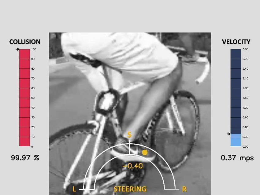
D. Qualitative Results
In Fig. 8 and, more extensively in the supplementary video,
it is possible to observe the behaviour of DroNet in some of
the considered testing environments. Unlike previous work [9],
our approach always produced a safe and smooth flight. In
particular, the drone always reacted promptly to dangerous
situations, e.g. sudden occlusions by bikers or pedestrians in
front of it.
To better understand our flying policy, we employed the
technique outlined in [24]. Fig. 7 shows which part of an Fig. 6: High altitude Outdoor 1: In order to test the ability
image is the most important for DroNet to generate a steering of DroNet to generalize at high altitude, we made the drone
decision. Intuitively, the network mainly concentrates on the fly at 5 m altitude in the testing environment Outdoor 1.
“line-like” patterns present in a frame, which roughly indicate Table II indicates that our policy is able to cope with the large
the steering direction. Indeed, the strong coupling between difference between the viewpoint of a camera mounted on a
perception and control renders perception mainly sensitive to car (1.5 m) and the one of the UAV.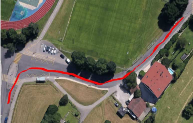
LOQUERCIO et al.: DRONET: LEARNING TO FLY BY DRIVING                                                                                7

               (a)                               (b)                              (c)                              (d)
Fig. 7: Activation maps: Spatial support regions for steering regression in city streets, on (a) a left curve and (b) a straight
path. Moreover we show activations on (c) an indoor parking lot, and (d) an indoor corridor. We can observe that the network
concentrates its attention to “line-like” patterns, which approximately indicate the steering direction.

Fig. 8: DroNet predictions: The above figures show predicted steering and probability of collision evaluated over several
experiments. Despite the diverse scenarios and obstacles types, DroNet predictions always follow common sense and enable
safe and reliable navigation.

the features important for control. This explains why DroNet         scenes while requiring no previous knowledge about them.
generalizes so well to many different indoor and outdoor             More specifically, in contrast to traditional approaches, there
scenes that contain “line–like” features. Conversely, we expect      is no need to be given a map of the environment, or build
our approach to fail in environments missing those kind of           it online, pre-define collision-free waypoints and localize
features. This was for example the case for an experiment            within this map. An advantage with respect to other CNN-
we performed in a forest, where no evident path was visible.         based controllers [13], [9], [12], [6], [11] is, that we can
However, placed in a forest surrounding with a clearly visible       leverage the large body of literature present on steering angle
path, the drone behaved better.                                      estimation [16], [17] on both the data and the algorithmic point
   Furthermore, the importance of our proposed methodology           of view. As shown in the experiments, this gives our method
is supported by the difficulties encountered while carrying out      high generalization capabilities. Indeed, the flying policy we
outdoor city experiments. If we want a drone to learn to fly in      provide can reliably fly in non-trivial unseen scenarios without
a city, it is crucial to take advantage of cars, bicycles or other   requiring any re-training or fine-tuning, as it is generally
manned vehicles. As these are already integrated in the urban        required by CNN-based approaches [11]. Additionally, the
streets, they allow to collect enough valid training data safely     very simple and optimized network architecture can make our
and efficiently.                                                     approach applicable to resource constrained platforms. The
                                                                     limitations are primarily that the agile dynamics of drones
                         V. D ISCUSSION                              is not fully exploited, and that it is not directly possible
  Our methodology comes with the advantages and limitations          to explicitly give the robot a goal to be reached, as it is
inherent to both traditional and learning-based approaches. The      common in other CNN-based controllers [13], [9], [25]. There
advantages are that, using our simple learning and control           are several ways to cope with the aforementioned limitations.
scheme, we allow a drone to safely explore previously unseen         To exploit the drone agility, one could generate 3D collision-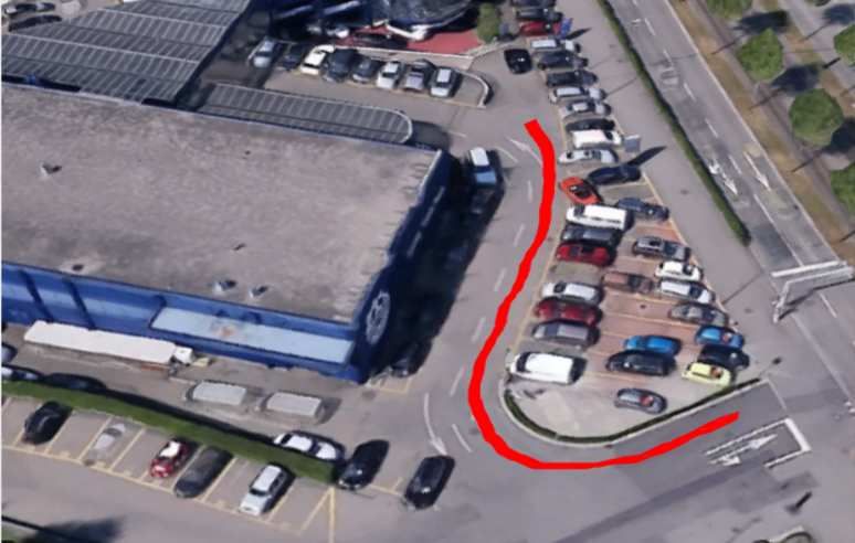
8                                                                 IEEE ROBOTICS AND AUTOMATION LETTERS. PREPRINT VERSION. ACCEPTED JANUARY, 2018

free trajectories, as e.g. in [25], when high probability of                         [7] T. P. Lillicrap, J. J. Hunt, A. Pritzel, N. Heess, T. Erez, Y. Tassa,
collision is predicted. To generalize to goal-driven tasks, one                          D. Silver, and D. Wierstra, “Continuous control with deep reinforcement
                                                                                         learning,” arXiv preprint arXiv:1509.02971, 2015.
could either provide the network with a rough estimate of                            [8] J. Schulman, S. Levine, P. Abbeel, M. Jordan, and P. Moritz, “Trust
the distance to the goal [26], or, if a coarse 2D map of                                 region policy optimization,” in Proceedings of the 32nd International
the environment is available, exploit recent learning-based                              Conference on Machine Learning (ICML-15), 2015, pp. 1889–1897.
                                                                                     [9] A. Giusti, J. Guzzi, D. C. Cirean, F. L. He, J. P. Rodrguez, F. Fontana,
approaches developed for ground robots [27]. Moreover, to                                M. Faessler, C. Forster, J. Schmidhuber, G. D. Caro, D. Scaramuzza, and
make our system more robust, one could produce a measure                                 L. M. Gambardella, “A machine learning approach to visual perception
of uncertainty, as in [28]. In such a way, the system could                              of forest trails for mobile robots,” IEEE Robotics and Automation
                                                                                         Letters, 2016.
switch to a safety mode whenever needed.                                            [10] D. Gandhi, L. Pinto, and A. Gupta, “Learning to fly by crashing,” in 2017
                                                                                         IEEE/RSJ International Conference on Intelligent Robots and Systems
                                                                                         (IROS), sep 2017.
                             VI. C ONCLUSION                                        [11] Y. Zhu, R. Mottaghi, E. Kolve, J. J. Lim, A. Gupta, L. Fei-Fei, and
   In this paper, we proposed DroNet: a convolutional neural                             A. Farhadi, “Target-driven visual navigation in indoor scenes using
                                                                                         deep reinforcement learning,” in 2017 IEEE International Conference
network that can safely drive a drone in the streets of a city.                          on Robotics and Automation (ICRA), may 2017.
Since collecting data with a UAV in such an uncontrolled                            [12] G. Kahn, T. Zhang, S. Levine, and P. Abbeel, “PLATO: Policy learning
environment is a laborious and dangerous task, our model                                 using adaptive trajectory optimization,” in 2017 IEEE International
                                                                                         Conference on Robotics and Automation (ICRA). IEEE, may 2017.
learns to navigate by imitating cars and bicycles, which already                         [Online]. Available: https://doi.org/10.1109%2Ficra.2017.7989379
follow the traffic rules. Designed to trade off performance for                     [13] N. Smolyanskiy, A. Kamenev, J. Smith, and S. Birchfield, “Toward
processing time, DroNet simultaneously predicts the collision                            low-flying autonomous mav trail navigation using deep neural networks
                                                                                         for environmental awareness,” IEEE/RSJ Int. Conf. Intell. Robot. Syst.
probability and the desired steering angle, enabling a UAV to                            (IROS), 2017.
promptly react to unforeseen events and obstacles. We showed                        [14] F. Sadeghi and S. Levine, “CAD2rl: Real single-image flight without a
through extensive evaluations that a drone can learn to fly in                           single real image,” in Robotics: Science and Systems XIII, jul 2017.
                                                                                    [15] M. Mancini, G. Costante, P. Valigi, T. A. Ciarfuglia, J. Delmerico,
cities by imitating manned vehicles. Moreover, we demon-                                 and D. Scaramuzza, “Towards domain independence for learning-based
strated interesting generalization abilities in a wide variety of                        monocular depth estimation,” IEEE Robot. Autom. Lett., 2017.
scenarios. Indeed, it could be complementary to traditional                         [16] H. Xu, Y. Gao, F. Yu, and T. Darrell, “End-to-end learning of driving
                                                                                         models from large-scale video datasets,” in Proc. IEEE Int. Conf.
“map-localize-plan” approaches in navigation-related tasks,                              Comput. Vis. Pattern Recog., July 2017.
e.g. search and rescue, and aerial delivery. For this reason,                       [17] J. Kim and J. Canny, “Interpretable learning for self-driving cars by
we release our code and datasets to share our findings with                              visualizing causal attention,” in The IEEE International Conference on
                                                                                         Computer Vision (ICCV), Oct 2017.
the robotics community.                                                             [18] K. He, X. Zhang, S. Ren, and J. Sun, “Deep residual learning for image
                                                                                         recognition,” in Proceedings of the IEEE conference on computer vision
                                                                                         and pattern recognition, 2016, pp. 770–778.
                           ACKNOWLEDGEMENT                                          [19] Y. Bengio, J. Louradour, R. Collobert, and J. Weston, “Curriculum
   This project was funded by the Swiss National Center of                               learning,” in Proceedings of the 26th annual international conference
                                                                                         on machine learning. ACM, 2009, pp. 41–48.
Competence Research (NCCR) Robotics, through the Swiss                              [20] D. Kingma and J. Ba, “Adam: A method for stochastic optimization,”
National Science Foundation, and the SNSF-ERC starting                                   International Conference on Learning Representations, 2015.
grant. This work has also been partially supported by the Min-                      [21] Udacity, “An Open Source Self-Driving Car,” https://www.udacity.com/
                                                                                         self-driving-car, 2016.
isterio de Economı́a, Industria y Competitividad (AEI/FEDER)                        [22] S. Hochreiter and J. Schmidhuber, “Long short-term memory,” Neural
of the Spanish Government under project TEC2016-75981                                    Computation, vol. 9, no. 8, pp. 1735–1780, nov 1997.
(IVME).                                                                             [23] K. Simonyan and A. Zisserman, “Very deep convolutional networks for
                                                                                         large-scale image recognition,” arXiv preprint arXiv:1409.1556, 2014.
                                                                                    [24] R. R. Selvaraju, M. Cogswell, A. Das, R. Vedantam, D. Parikh, and
                                 R EFERENCES                                             D. Batra, “Grad-CAM: Visual explanations from deep networks via
                                                                                         gradient-based localization,” in 2017 IEEE International Conference on
    [1] S. Scherer, J. Rehder, S. Achar, H. Cover, A. Chambers, S. Nuske, and            Computer Vision (ICCV), oct 2017.
        S. Singh, “River mapping from a flying robot: state estimation, river       [25] S. Yang, S. Konam, C. Ma, S. Rosenthal, M. Veloso, and S. Scherer,
        detection, and obstacle mapping,” Autonomous Robots, vol. 33, no. 1-2,           “Obstacle avoidance through deep networks based intermediate percep-
        pp. 189–214, 2012.                                                               tion,” arXiv preprint arXiv:1704.08759, 2017.
    [2] N. Michael, S. Shen, K. Mohta, Y. Mulgaonkar, V. Kumar, K. Nagatani,        [26] M. Pfeiffer, M. Schaeuble, J. Nieto, R. Siegwart, and C. Cadena, “From
        Y. Okada, S. Kiribayashi, K. Otake, K. Yoshida et al., “Collaborative            perception to decision: A data-driven approach to end-to-end motion
        mapping of an earthquake-damaged building via ground and aerial                  planning for autonomous ground robots,” in IEEE Int. Conf. Robot.
        robots,” Journal of Field Robotics, vol. 29, no. 5, pp. 832–841, 2012.           Autom. (ICRA), 2017.
    [3] M. Faessler, F. Fontana, C. Forster, E. Mueggler, M. Pizzoli, and           [27] W. Gao, D. Hsu, W. S. Lee, S. Shen, and K. Subramanian, “Intention-
        D. Scaramuzza, “Autonomous, vision-based flight and live dense 3D                net: Integrating planning and deep learning for goal-directed autonomous
        mapping with a quadrotor MAV,” J. Field Robot., vol. 33, no. 4, pp.              navigation,” in Proceedings of the 1st Annual Conference on Robot
        431–450, 2016.                                                                   Learning, 2017.
    [4] S. Shen, Y. Mulgaonkar, N. Michael, and V. Kumar, “Multi-sensor fusion      [28] C. Richter and N. Roy, “Safe visual navigation via deep learning and
        for robust autonomous flight in indoor and outdoor environments with             novelty detection,” in Robotics: Science and Systems XIII, jul 2017.
        a rotorcraft MAV,” in Robotics and Automation (ICRA), 2014 IEEE
        International Conference on. IEEE, 2014, pp. 4974–4981.
    [5] S. Lynen, T. Sattler, M. Bosse, J. Hesch, M. Pollefeys, and R. Siegwart,
        “Get out of my lab: Large-scale, real-time visual-inertial localization,”
        in Robotics: Science and Systems XI, jul 2015.
    [6] S. Ross, N. Melik-Barkhudarov, K. S. Shankar, A. Wendel, D. Dey,
        J. A. Bagnell, and M. Hebert, “Learning monocular reactive UAV control
        in cluttered natural environments,” in IEEE Int. Conf. Robot. Autom.
        (ICRA), 2013, pp. 1765–1772.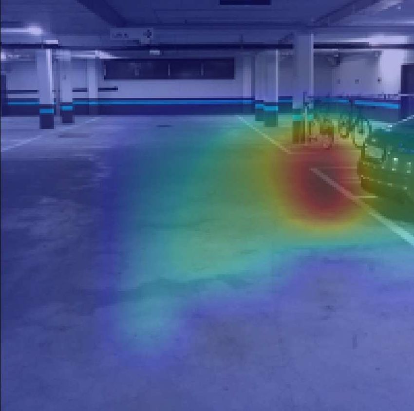
You can also read