EAST COAST LOW EXTREME WEATHER SCENARIO - Scenario for the 12th Australasian Natural Hazards Management Conference - Bushfire & Natural ...
←
→
Page content transcription
If your browser does not render page correctly, please read the page content below

17-19 JUNE 2019
AUSTRALIAN INSTITUTE OF
SPORT, CANBERRA

EAST COAST
LOW EXTREME
WEATHER
SCENARIO
  Scenario for the 12th Australasian Natural
  Hazards Management Conference

  HOSTED BY THE BUSHFIRE AND NATURAL HAZARDS CRC

BNHCRC.COM. AU
    @bnhcrc
This work is licensed under a Creative Commons
              Attribution-Non Commercial 4.0 International Licence.

All material in this document, except as identified below, is licensed
under the Creative Commons Attribution-Non-Commercial 4.0
International Licence.
Material not licensed under the Creative Commons licence:
•    Department of Industry, Science, Energy and Resources logo
•    Cooperative Research Centres Programme logo
•    Bushfire and Natural Hazards CRC logo
•    All photographs
All content not licensed under the Creative Commons licence is all
rights reserved. Permission must be sought from the copyright owner
to use this material.
Publisher: Bushfire and Natural Hazards CRC, East Melbourne, Victoria.
February 2020.
Report no. 548.2020
Disclaimer: The Bushfire and Natural Hazards CRC advises that
the information contained in this publication comprises general
statements based on scientific research. The reader is advised and
needs to be aware that such information may be incomplete or
unable to be used in any specific situation. No reliance or actions must
therefore be made on that information without seeking prior expert
professional, scientific and technical advice. To the extent permitted
by law, the Bushfire and Natural Hazards CRC exclude all liability to any
person for any consequences, including but not limited to all losses,
damages, costs, expenses and any other compensation, arising directly
or indirectly from using this publication (in part or in whole) and any
information or material contained in it.
Citation: Bushfire and Natural Hazards CRC (2020), East Coast Low
extreme weather scenario: scenario for the 12th Australasian Natural
Hazards Management Conference (548.2020).

2                                                                           Bushfire and Natural Hazards CRC
Scenario overview
This is a fictional scenario developed for                  limited fuel reduction through prescribed burning has
                                                            been possible because of extremely dry fuels, lack of soil
use at the 12th Australasian Natural Hazards
                                                            moisture and higher than normal temperatures.
Management Conference, developed in
partnership with the Bureau of Meteorology,
Geoscience Australia and Risk Frontiers. This
scenario should be read in conjunction with
the report on the 12th Australasian Natural
Hazards Management Conference, Cascading
extreme weather beyond our experience:
are we ready?, published by the Bushfire and
Natural Hazards CRC.

1. DISCLAIMER AND INTRODUCTION
This scenario has been developed for the 12th
                                                            Figure 1: The fictional rainfall outlook for September to
Australasian Natural Hazards Management Conference.         November 2020 used in the scenario.
It is based on climate, environment and weather events
that are plausible. The combination of events, locations,
areas of impact and human behavior are not based on
any real event.                                             3. WEDNESDAY 16 SEPTEMBER 2020:
As you see what unfolds during the scenario, we ask you
                                                            BUSHFIRES ARRIVE EARLY IN NSW
to focus on the nature and scale of the events that are     Wednesday 16 September 2020 is a day of extreme fire
unfolding, and the connections between them. And to         danger, strong winds and temperatures exceeding 35
begin thinking ‘what could we do to reduce, minimise or     degrees in most of NSW. Multiple fires start and several
avoid the short and long-term impacts?’                     spread quickly:
The hypothetical event is based in New South Wales,         •    Blue Mountains (north) fire – the fire runs fast
but can, and should, be considered in the context of any         in prevailing wind and threatens communities
equivalent location across Australia or New Zealand.             including Blackheath and Medlow Bath
The impacts capture a range of likely outcomes to                –    This fire is controlled with the loss of a few
illustrate the extent of the effects of the weather                   outbuildings, and eventually extinguished,
scenario, but do not attempt to catalogue all of the                  with 5,000 hectares of forest burnt.
impacts and their extent.                                   •    Snowy Mountains fire – threatening the Tumut 3
                                                                 hydro power station, the town of Talbingo and the
                                                                 Bogong wilderness area
2. SEPTEMBER 2020: CLIMATE
                                                                 –    This fire is controlled and eventually
OUTLOOK                                                               extinguished, with fire suppression effectively
NSW has been in a period of significant drought since                 protecting the power station and power
the summer of 2018/2019. Winter rainfalls have been                   transmission assets. 12,000 hectares of forest
the lowest on record across the state, water storages                 were burnt.
across Sydney are low and dropping, and the Sydney          •    Upper Hunter Valley fire – threatening the Wollemi
desalination plant is operating at full capacity.                and Yengo national parks, the Singleton military
The Bureau of Meteorology Drought Statement reflects             area and several coal mines (Mulga Coal, Blakefield
a very dry landscape across NSW and as a consequence,            South Colliery and Hunter Valley Operations North
                                                                 and South)

A report on the 12th Australasian Natural Hazards Management Conference                                                 3
–    The fire is controlled and then extinguished,      two days. Storms are expected to increase over coastal
          with the coal mines protected and 3,500            and central NSW, developing into severe storms over
          hectares of forest burnt.                          the Sydney area with intense rainfall. The Sydney and
•    Blue Mountains (south) fire – burning in the            Illawarra regions are the most likely to see heavy falls
     Blue Mountains National Park and Burragarong            that may cause flash flooding. A flood watch is issued for
     Conservation Reserve, forested catchment for the        all coastal rivers. Dangerous wind gusts and hazardous
     Warragamba Dam                                          surf conditions are likely to continue into the weekend.
     –    The fire is contained, and then extinguished,
          with 15,000 hectares burnt.
•    Kembla State Forest fire – burning in the forested
     catchment for the Avon and Nepean Dams
     –    Fire contained, 14,000 hectares burnt, but not
          before the 330 kilovolt electricity distribution
          lines through catchments de-energised, but
          not damaged during fires. The fires posed a
          short-term risk to power security.

                                                             Figure 3: The fictional Severe Weather Warning for 8 October
                                                             2020 used in the scenario.

Figure 2: Location of fires in the scenario.

4. WEDNESDAY 7 OCTOBER 2020:
SEVERE WEATHER ALERT FOR
COASTAL REGIONS OF EASTERN
AUSTRALIA
A developing low pressure system is predicted to
become a significant East Coast Low. The East Coast
Low is predicted to move slowly following landfall, and
to have significant storm tides in excess of 2 metres
that will be made worse by celestial alignments. It is
expected that there will be significant wave action from
the north east, with significant coastal erosion.

                                                             Figure 4: Graphical representation of the area that the fictional
5. THURSDAY 8 OCTOBER 2020:                                  Severe Weather Warning for 8 October 2020 applies to.
SEVERE WEATHER ALERT - EAST
COAST LOW EXPECTED TO IMPACT
NSW COAST FROM WOLLONGONG TO                                 6. FRIDAY 9 OCTOBER 2020, 9.30 AM:
NEWCASTLE                                                    THE RAIN STARTS IN SYDNEY
The Bureau of Meteorology released a Severe Weather          Rain begins falling at 9.30 am and intensifies quickly
Warning for an East Coast Low developing off the             after morning travel peak. Some businesses allowed
coast bringing wild and wet weather with potential for       staff to work from home in preparation for the expected
heavy rain, flooding and damaging wind over the next         severe weather, but more than 70 per cent of the daily
                                                             workforce are still in the Sydney CBD. More people have

4                                                                                     Bushfire and Natural Hazards CRC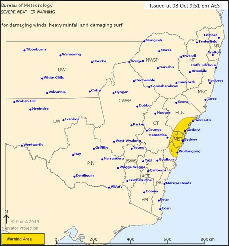
chosen to drive to work, expecting public transport to fail       feet across the city by floodwaters, half requiring
in the bad weather. Some came into work early and were            medical treatment for head injuries and bone
planning to leave early, but the storm and associated             fractures
flooding and traffic congestion came first, effectively       •   more than 200 significant vehicle accidents have
trapping them in the CBD. The emergency services, led             been reported across Sydney requiring emergency
by the NSW State Emergency Service, are prepared for              services attendance, many more minor accidents
the forecast weather system.                                      are blocking roadways
Some impacts begin to be felt immediately:                        –    Twenty three of the accidents have been
                                                                       reported with people trapped and with
•   Renewable energy generation across the area
                                                                       suspected serious injuries.
    affected by the weather system drops to almost
                                                                  –    Emergency services are experiencing extreme
    zero.
                                                                       difficulty in moving response vehicles around
                                                                       the city, and all air fleets are grounded.
7. FRIDAY 9 OCTOBER 2020,                                         –    Major disruptions are affecting the road
10.30 AM: FLASH FLOODING AND                                           network:
BUILDING INUNDATION OCCURS                                             ▪    road tunnels are flooding
ACROSS THE SYDNEY CBD                                                  ▪    signals are failing
                                                                       ▪    there is major surface water inundation
Major flooding is experienced in the Sydney CBD,
                                                                       ▪    stormwater systems are backing up and
centered around Pitt Street and running down to Sydney
                                                                            overflowing, with reports of pit covers
Harbour. Water is pooling in low lying areas, including
                                                                            exploding.
King Street.
                                                                  –    Significantly, central traffic management and
Floodwater in Pitt Street is running at depth of 0.5                   coordination systems are failing and there
metres, with fast flow velocities. Significant impacts are             are reports of sinkholes around suspected
causing massive disruptions including:                                 damaged stormwater pipes in Parramatta
•   Several parked cars are washed down the street.                    Road in Parramatta and Henderson Road near
•   Several cars being driven up Pitt Street from Circular             Redfern.
    Quay are washed backwards down the street with            Elsewhere, there is flooding reported in the Chatswood–
    passengers inside.                                        Sydenham Metro Tunnel and reports of construction
•   Underground carparks and loading docks are                workers trapped and unable to evacuate from the
    flooding.                                                 construction site. The Barangaroo, Victoria Cross, Martin
•   Basement shops are flooding.                              Place and Pitt Street Metro station construction sites are
•   Building ground floors and basements are flooding.        also flooding.

Across the greater Sydney area:                               Shipping movements have stopped, port operations are
                                                              closed and any boats already at sea must remain away
•   stormwater drains are backing up and overflowing          from the coast. Fishing operations are cancelled and the
    –    There is fast moving surface water to depth          harbour ferries are not running.
         of 20 centimetres in streets leading to Darling
                                                              Communications systems are struggling to cope.
         Harbour, including Bathurst Street, Market
                                                              Mobile networks have become unstable, and towers are
         Street and Druitt Street. An unknown number
                                                              beginning to fail across the Sydney basin. In areas with
         of pedestrians have been swept off their feet by
                                                              power failure, 40 per cent of private residences with NBN
         the water and have fallen heavily
                                                              lose voice and data communication.
•   there is significant flooding in Rose Bay, Alexandria,
    Annandale and Parramatta                                  People in high rise buildings are reporting significant
•   a flood watch has been issued for coastal                 immediate threats:
    catchments and all areas throughout the central           •   Lift failures have been reported in 30 buildings, with
    coast of NSW for moderate to major riverine flooding          many people now trapped. Loss of communications
•   there are warnings for flash flooding in the Illawarra        means that more people could be trapped in lifts
    and Shoalhaven areas as the weather system                    and unable to communicate.
    pushes southwards                                         •   There has been cracking in internal walls of a newly
•   flash flooding has been reported around the Sydney            constructed 50 storey residential tower building
    basin                                                         in Parramatta. In the same building, the electricity
    –    Across the greater Sydney basin, traffic lights          supply has failed, there is flooding in the basement
         are failing, stormwater is flowing into subway           and residents in 38 apartments located on the
         stations, and there have been 50 flood rescues           higher floors are unable to open exit doors. An
         in the first two hours. Four people are still            unknown number of residents are trapped inside
         missing in the floodwaters, and more rescues             apartments. There are reports of fire escape doors
         expected.                                                being jammed and unable to be opened. On the
    –    There have been 83 assisted evacuations.                 ground floor of the apartment building, there is a
                                                                  childcare centre with 70 childcare places.
•   more than 200 people have been washed off their

A report on the 12th Australasian Natural Hazards Management Conference                                                    5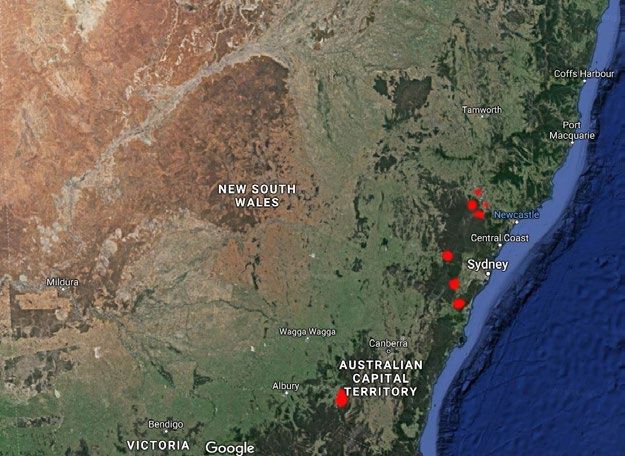
•   Scaffolding on the Sydney GPO in George Street is         •   ABC News Channel (showing footage of the
    detaching from the building and threatening to fall           cascading event).
    across George Street.
                                                              Backup plans are put into action and the responsibility
•   The Emu Plains Correctional Facility is at risk of
                                                              for emergency broadcasting is transferred to another
    flooding – it is located on the floodplain at Emu
                                                              ABC facility interstate.
    Plains in the Hawkesbury-Nepean Valley.

                                                              11. FRIDAY 9 OCTOBER 2020, 12.15 PM:
8. FRIDAY 9 OCTOBER 2020, 11.30 AM:
                                                              MASSIVE INFLOWS BEGIN INTO WATER
EXTREME TIDES, A STORM SURGE AND
                                                              STORAGES
COASTAL INUNDATION
                                                              With significant and continuous rainfall over the last
Impacts are beginning to be experienced in coastal            18-24 hours covering the Sydney basin, central west, Blue
areas. Peak tides of 2.5 metres are reached at 11.30 am,      Mountains and Wollongong escarpment, large volumes
with waves above 4 metres. Massive coastal erosion is         of water are moving into waterways and catchments:
being reported at Collaroy beach where buildings are
under threat.                                                 •   Warragamba, Nepean and Avon dams receive
                                                                  inflows massively contaminated by ash, debris
There is significant media attention as waves are starting        (burnt vegetation) and soil/mud. Inflows are
to undermine buildings. The NSW SES is monitoring                 expected to continue for extended periods of
known coastal erosion hotspots around the Central                 time. It is anticipated that animal carcasses will be
Coast and the Northern Beaches where local residents              washed into the catchments, and that there will be
remain on edge.                                                   significant erosion of landscape across the burnt
Some brave (foolish) surfers take to the water, risking           areas of the catchments.
their lives and the lives of lifeguards. Aircraft have been
requested to search for a rock fisherman washed from          12. FRIDAY 9 OCTOBER 2020,
rocks near Coogee, but are unable to take off because of
the extreme weather conditions. The fisherman remains
                                                              1.00 PM: BLACKOUTS BEGIN ACROSS
missing.                                                      THE SYDNEY CBD
Several councils commence cutting sand banks to               With the extreme weather battering Sydney, wind gusts
reduce flooding along coastal lagoons.                        in excess of 125 kilometres per hour have been recorded
                                                              through Sydney, with even stronger gusts along the
                                                              coast.
9. FRIDAY 9 OCTOBER 2020, 11.30 AM:
SYDNEY AIRPORT OPERATIONS ARE                                 Many powerlines have come down across greater Sydney
                                                              due to wind and tree damage, and the impacts of
SEVERELY IMPACTED                                             localised flash flooding. There are power outages across
The storms have disrupted air travel in and out of Sydney.    the CBD, the greater Sydney basin, and the Hawkesbury-
With low cloud, very heavy rain, significant surface water    Nepean Valley. Impacts include:
on runways and a high tide peaking at more than 2.5
                                                              •   An estimated 80,000 customers are without power.
metres, a tidal surge begins to impact airport surfaces
                                                              •   The biggest outage affects 45,000 customers – an
as drainage becomes ineffective and water can be seen
                                                                  underground cable fault at the Double Bay zone
pooling across taxiways and runways.
                                                                  substation1 is affecting homes and businesses in
Ground staff are unable to safely and effectively load            Randwick, Bondi Junction, Bondi, Kensington,
aircraft (food, service and luggage) due to the intensity         Waverley, Double Bay, Woollahra, Bronte, Bellevue
of the rain. Passengers are unable to get to, or leave,           Hill, Clovelly, Coogee and Rose Bay.
the airport due to traffic interruptions. There is a high     •   Twenty per cent of backup generators in affected
potential for debris on runways.                                  businesses fail within two hours.
                                                              •   Power issues have been reported at the Prince of
10. FRIDAY 9 OCTOBER 2020, 12.00 PM:                              Wales and Sydney Children’s Hospital.
ABC ULTIMO STUDIO LOSES POWER,                                •   Renewable energy sources are not producing
IMPACTING ABC’S EMERGENCY                                         electricity.

BROADCASTING
The substation supplying the ABC building in Ultimo           1 https://www.abc.net.au/news/2019-01-31/power-outag-
fails, leaving the 14 storey building reliant on two            es-across-sydney-affecting-thousands/10766530
generators. Within 30 minutes, the underground
carparks flood. The flooding affects the pumps and fuel
supply for those two generators, and the generators fail.
The whole of the ABC Ultimo building is evacuated and
shut down within 20 minutes, including:
•   ABC Radio Sydney (which does the emergency
    broadcasting)

6                                                                                   Bushfire and Natural Hazards CRC
13. FRIDAY 9 OCTOBER 2020,
1.15 PM ONWARDS: PUBLIC TRANSPORT
ACROSS GREATER SYDNEY
SIGNIFICANTLY DISRUPTED
There is chaos in the public transport system. Many parts
of the rail system are flooded, and power has been lost
to significant sections of the network. At many stations,
subway access is flooded and unsafe. Some passengers
are stuck on trains and others stranded on flooded train
platforms after flash flooding hit the Eastwood area.
Buses are unable to move around the streets following
designated routes and many passengers are unwilling to
get off buses. Where passengers do disembark, there are
                                                              Figure 5: The fictional Severe Thunderstorm Warning for 10
hundreds of slips, trips and falls.                           October 2020 used in the scenario.
There are significant rises being recorded along the
Georges River with a moderate to major flood warning          Emergency services issue a Red Flag Warning, advising
issued for the catchment. The NSW SES are preparing           all emergency services of the impending safety threat
for the evacuation of around 1,000 people. This follows       posed by the predicted storm, and advising them
significant flash flooding throughout the Fairfield area in   to cease all activities and return to their stations.
the early evening.                                            Agencies are permitted to respond to life-threatening
                                                              emergencies but only if it is safe to do so.
14 FRIDAY 9 OCTOBER 2020, 11.00 PM:
SEVERE WEATHER BEGINS TO EASE,                                16. SATURDAY 10 OCTOBER, 10.00 PM:
BUT RAIN AND WIND CONTINUES. IN                               MASSIVE SLOW-MOVING HAILSTORM
SYDNEY, THE IMPACT OF THE STORM IS                            IMPACTS BATHURST AND THE RACE
NOW BECOMING CLEAR                                            CIRCUIT AT MOUNT PANORAMA
As the severe weather begins to ease, the impact of the       There is limited warning of the severe storm for Bathurst
East Coast Low begin to emerge. This includes:                and surrounding areas. Bathurst is at the edge of current
•   number of homes without power: 250,000                    weather radar coverage, and the Bureau of Meteorology
                                                              was unable to get a detailed and accurate estimate of
•   number of businesses without power: 35,000
                                                              the storm threat prior to the issuing of the warning at
•   flood rescues: 194                                        9.30 pm.
•   assisted evacuations: 1,593
•   damaged cars: 537
•   roads blocked by fallen trees and power lines: 350
•   requests for assistance: over 35,000
•   building damage
    –    damaged but habitable: 17,500
    –    damaged and uninhabitable: 5,300
•   people sleeping rough in impact area: 550
Rain and moderate winds continue to impact on the
greater Sydney and Illawarra areas overnight, before
easing at sunrise.

15. SATURDAY 10 OCTOBER, 9.30 PM:
SEVERE STORM DETECTED NEAR
BATHURST
The Bathurst 1000 V8 Supercar race weekend is in full
swing. Following a full day of racing and an evening
concert there is a party atmosphere on the mountain at
the Mount Panorama circuit and in the town.
The Bureau of Meteorology issued a severe storm
warning, and associated information.

                                                              Figure 6: Graphical representation of the area that the fictional
                                                              Severe Weather Warning for 10 October 2020 applies to.

A report on the 12th Australasian Natural Hazards Management Conference                                                           7
The area is hit with extreme wind gusts and massive                  ▪   crush injuries from people rushing to try
hail. The impact is sufficient to bring down the two                     and get out of the hail
power feed lines into the Mount Panorama substation.            –    most of the tents have been severely damaged
Powerlines across the area are on timber poles and are               or destroyed
expected to have suffered significant damage2.                  –    most mobile homes and cars are badly
There is an intense hailstorm with large hail up to 5                damaged, the majority with windows broken.
centimetres in diameter, falling for 30 minutes over
Mount Panorama and Bathurst township, accompanied           18. SATURDAY 10 OCTOBER 2020
by very strong winds. At the time, there are 33,500
campers on the mountain, many affected by alcohol.
                                                            11.00 PM: RAPID IMPACT ASSESSMENT
Adding to the risks, there are many fire drums across       FROM MOUNT PANORAMA AND
the campsites, some covered with tarpaulin shelters,        BATHURST
and there is no real protective cover for people.
Approximately a third of the campsites have a car parked
                                                            On Mount Panorama
onsite.
                                                            The scale of the impact has become clearer as race
17. SATURDAY 10 OCTOBER, 10.15 PM:                          officials and emergency services survey the Mount
                                                            Panorama area. Communication outages and the scale
FIRST REPORTS ARE RECEIVED FROM                             of the event means that the information at this time is
BATHURST                                                    incomplete. What is known is:
Once the storm passes, an initial impact assessment         •   there have been several fatalities:
from the scene (derived from a combination of event             –    At least five people have been killed by
management teams and social media reporting) begins                  falling trees and the collapse of a temporary
to paint a picture of what has happened:                             grandstand that people were sheltering under.
•   A very dangerous hailstorm with extremely strong            –    At least 25 people have died from crush injuries
    winds has impacted the entire town of Bathurst and               as panicked campers desperately sought
    Mount Panorama.                                                  shelter form the hail.
•   Trees have been blown down, damaging houses             •   there are a massive number of injuries across the
    and powerlines.                                             mountain:
•   Temporary structures across the Mount Panorama              –    At least 136 crush injuries require hospital care.
    site have collapsed, trapping campers trying to             –    At least 195 people suffering from trips and falls
    shelter from the extreme weather.                                require hospital care.
•   Mobile communications have failed across the                –    At least 1,538 hail injuries require medical care,
    entire town, and across Mount Panorama (wind and                 with an unknown number of serious injuries,
    hail damage, loss of electricity).                               including head injuries, broken limbs and
•   NBN based communications have been severely                      damage to eyes and faces:
    impacted, with more than 70 per cent of                         ▪      over 4,000 less serious injuries not
    homeowners losing data and landline phone                              requiring hospital care, including bruising,
    services.                                                              sprains and strains, and alcohol and drug-
•   Electricity supply has been lost across the town                       related conditions.
    and at Mount Panorama, the Panorama to Orange           •   there is extensive damage across the site. The list
    and Panorama to Wallerawang 132 kilovolt lines are          below excludes racing infrastructure and vehicles:
    down in multiple locations, interrupting supply to          –    There is extensive vehicle damage including
    Bathurst.                                                        more than 5,000 cars, RVs and 4WDs damaged,
•   Onsite paramedics and security have been                         many not driveable; and more than 1,000 motor
    sheltering for their own personal safety; all of                 homes damaged, many not driveable.
    their vehicles have been damaged by the hail and            –    More than 90 per cent of the tents in the
    are unserviceable. There are a limited number of                 camping areas are damaged and unusable.
    emergency services vehicles available from the              –    Major infrastructure has been severely
    permanent Bathurst emergency services facilities.                damaged and services disrupted:
•   A small number of evacuees from Mount Panorama                  ▪      There is a total power failure across the
    campsites that have reached the command centre                         Bathurst region, which is expected to
    have reported:                                                         continue for at least 12 hours.
    –     a high frequency of injuries, including:                  ▪      All mobile phone tower fixed infrastructure
         ▪     bruising from hail                                          is damaged, and mobile phone services
         ▪     broken limbs                                                will remain out until transportable
         ▪     motor vehicle accidents as some people                      communication trailers arrive on scene.
               tried to escape the hail and protect their
               vehicles
                                                            2 Source: Darren Spoor, AEMO
         ▪     burns from people pushed into fire drums

8                                                                                 Bushfire and Natural Hazards CRC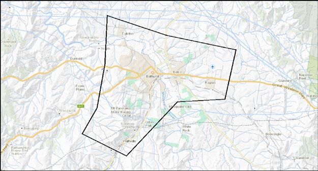
▪    There has been substantial (greater
                                                               BUILDING EXPOSURE, V9 SEPTEMBER 2017
              than 70 per cent) loss of terrestrial NBN
              communications that will continue until          RESIDENTIAL                              EVENT
              electricity supplies are restored.
                                                               Population count                         29,625
         ▪    There has been a total loss of fixed satellite
              based NBN communication that will                Dwelling count                           12,915
              continue until electricity supplies are
              restored and all damaged equipment has           Building count                           11,768
              been replaced.
         ▪    More than 90 per cent of the food vendors        Pre 1980 construction count              2,211
              facilities have been destroyed and are
              unusable.                                        Pre 1990 probably asbestos               5,002
                                                               containing products
         ▪    Major areas in the camping grounds are
              inaccessible due to damage from the              Reconstruction value                     $7,003,850,000
              storm and because they are now crime
              scenes.                                          Contents value                           $894,580,000
         ▪    Sanitation and hygiene facilities on the
              mountain are significantly damaged.              COMMERCIAL

                                                               Building count                           284
In the town of Bathurst
In and around Bathurst, the permanent emergency                Reconstruction value                     $949,270,000
services presence includes:
•   1 x police station
•   2 x fire stations                                          DWELLING ESTIMATES WHERE RESIDENTS:
•   1 x ambulance station                                      DEMOGRAPHIC                      EVENT            NSW(Av)
•   2 x SES facilities
                                                               Are all aged 65 or over          18.8%            17.4%
•   6 x rural/country fire facilities
•   1 x public hospital, including an emergency                Includes persons aged 14         24.9%            25.3%
    department and approximately 100 hospital beds             years and under
    in total
                                                               Includes an Indigenous           6.6%             3.6%
•   1 x private hospital, including 16 overnight surgical/
                                                               person
    medical beds.
                                                               Are a single parent family       8.0%             5.4%

                                                               Are in need of assistance        10.3%            10.5%
                                                               for self-care activities

                                                               Include persons not              0%               1.3%
                                                               proficient in English

                                                               Do not have access to a          8.1%             9.7%
                                                               motor vehicle

                                                               Have all not completed           19.9%            15.5%
                                                               Year 12 or higher

                                                               Moved to the region in the       9.4%             11%
                                                               last one year

                                                               Moved to the region in the       24.2%            30%
Figure 7: Bathurst and Mount Panorama.                         last five years

                                                               TOP FIVE EMPLOYING INDUSTRY:

                                                               ABS Census 2016 data not available for this release

                                                               Table 1: Known assets in Bathurst using the Australian
                                                               Exposure Impact Platform.

A report on the 12th Australasian Natural Hazards Management Conference                                                    9
Damage in the town of Bathurst has been less
catastrophic than what was experienced at Mount
Panorama, but there is still a significant level of damage:
•    There are no fatalities in the town, but there are a
     number of injuries:
     –    At least 47 people have injuries caused by the
          hail that require medical care.
     –    Another 281 people are known to have injuries
          caused by the hail, but do not require medical
          care.
•    There is significant damage to buildings and other
     infrastructure across Bathurst. The estimates have
     been based on the known assets in Bathurst, using
     the Australian Exposure Impact Platform (AEIP,
     https://www.aeip.ga.gov.au/):
          ▪     There are 12,915 dwellings in the impact
                area, and 30 per cent of these have some
                level of damaged (hail, wind, rain). 150
                houses are known to be uninhabitable.
          ▪     Of the six nursing homes in Bathurst, one
                is badly damaged and two are moderately
                damaged. There are two retirement
                villages and their current status is not
                known.
          ▪     Accommodation facilities were full for the
                weekend, and there has been damage:
              ▪      five hotels damaged, with at least 35
                     rooms unusable
              ▪      unknown number of AirBNB properties
                     are expected to have been damaged
                     and not habitable.
•    The Bathurst Correctional Facility is running on
     backup power.

SCENARIO ENDS

10                                                            Bushfire and Natural Hazards CRC
A report on the 12th Australasian Natural Hazards Management Conference 11
t +61 3 9412 9600
e office@bnhcrc.com.au
w www.bnhcrc.com.au
   @bnhcrc

   BUSHFIRE AND NATURAL
   HAZARDS CRC
WA S D E L I G H T E D T O H O S T T H E

  12TH AUSTRALASIAN NATURAL HAZARDS
  MANAGEMENT CONFERENCE

   17–19 JUNE 2019, AUSTRALIAN INSTITUTE OF SPORT, CANBERRA

The CRC conducts a multi-disciplinary research      The utilisation of the research by the end-
program on the major national issues across         users to the benefit of the broader Australian
the natural hazards spectrum. The CRC is a          community is critical to the whole process.
partnership of all Australian and New Zealand       The research program comprises three broad
fire, land and emergency service agencies;          themes, covering 12 clusters of projects, most of
more than 30 universities; plus many federal,       which span the priorities for those working in a
state and local government departments;             multi-hazard environment. The themes are:
professional and volunteer associations; and
                                                    •    Economics, policy and decision making
non-for-profit organisations.
                                                    •    Resilient people, infrastructure and
The CRC is providing a long-term knowledge base
                                                         institutions
that directly supports emergency services and
other government and non-government agencies        •    Bushfire and natural hazard risks
to protect their communities through work to
prevent, prepare for, respond to and recover from
natural disasters.                                  The CRC was created with a mission to:

Reduce the risks from       Reduce the social,          Contribute to the       Build internationally
 bushfire and natural         economic and              national disaster       renowned Australian
       hazards            environmental costs of        resilience agenda      research capacity and
                                 disasters                                           capability
You can also read