East Inishowen Sea Kayak Trail ... paddle by sandy beaches and cliffs, push around headlands
←
→
Page content transcription
If your browser does not render page correctly, please read the page content below
• Kinnagoe Bay

East Inishowen
   Sea Kayak Trail
... paddle by sandy beaches and cliffs, push around headlands,
          kayak in the shadow of rocky stacks and through caves!
LINKS WITH OTHER TRAILS
   The Foyle Canoe Trail runs from Lifford to Moville with the section from
   Culmore Point overlapping part of the Inishowen Trail. Stretching over 22
   nautical miles from the start of the River Foyle, this unique trail runs along
   the tidal river, passing through historic Derry city before following Lough
   Foyle’s varied coastline to the seaside town of Moville.
   From the northern end of Lough Foyle, seasoned kayakers can link up with
   the North Coast Sea Kayak Trail, which begins at Magilligan Point only 1.2 km
   across the Narrows at Greencastle - plan the crossing carefully, taking into
   account currents and wind, passage of commercial shipping and fi shing boat
   operations!
   WILDLIFE
                                      The screeches and calls of cliff nesting
• Seal on Inishtrahull                bird colonies dominate the soundtrack of
                                      this rugged coastline. Fulmar and manx
                                      shearwater elegantly skim the surface of the
                                      water, ‘shearing’ from side to side as they
                                      rhythmically alternate white under parts
                                      and dark upper body. Diving terns and
                                      soaring gannets (from Ailsa Craig in western
                                      Scotland) indicate shoals of fish near the
                                      surface. Keep a special eye out for the
                                      white rumped storm petrel, a dainty ocean
                                      wanderer, who patters along the wave tops
                                      in summer, flying ashore on dark nights to
                                      their island nest in some stony crevice.
   Peregrine and buzzard are cliff top predators with the added excitement of
   regular eagle sightings in recent years. Skua have been seen amongst gull and
   tern colonies, harassing and scavenging for a fi sh supper.
   Grey and common seals are year round residents, with the elusive otter
   commonly seen. Other regularly encountered sea mammals include porpoise
   and bottlenose dolphin plus occasional minke whale.
   Basking shark, the largest fish in the Atlantic Ocean, is a frequent summer
   visitor. Extremely docile in nature, this huge shark feeds by sieving plankton
   through gill rakers at the sides of its dramatic gaping mouth. During calm
   periods they frequently feed near the surface on the huge aggregations of
   plankton concentrated by the tidal slicks and currents along the coastline.
   Another interesting fish is the sun fish, with sightings focussed around
   Glengad Head.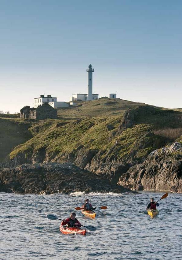
East Inishowen
                   Sea Kayak Trail

                               • Portmore, Inishtrahull

www.loughs-agency.org                   Page 1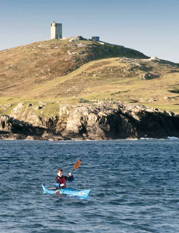
The East Inishowen Sea Kayak Trail
                                                               The East Inishowen Sea Kayak Trail runs around the coastline of the
                                                               Inishowen peninsula, from the outskirts of the walled city of Londonderry or
                                                               Derry, along the eastern side of this north Donegal peninsula to Malin Head,
                                                               the most northerly point on the Irish mainland.
                                                               Five nautical miles (NM) to the northeast lies Inishtrahull, a long deserted
                                                               island. The trip to “the island” runs across Inishtrahull Sound, a stretch of sea
                                                               exposed to the Atlantic swell and strong, complex tidal streams sweeping
                                                               around Malin Head. An interesting submarine feature in the sound, dropping
                                                               to 90 metres of water, is the Inishtrahull Trench.
                                                               From the relative shelter of Lough Foyle to an Atlantic shore, the Inishowen
                                                               Trail offers exploration of caves and off-shore islands, surf kayaking, harbour
                                                               paddles and wildlife.
                                                               This trail is most suited for experienced sea paddlers, with some sections
                                                               offering challenge and adventure to the skilled and well prepared paddler and
                                                               those led by a qualifi ed leader.
                                                               Before setting out, it is essential that the kayaker carefully studies forecasts
                                                               of wind speed and direction as well as researching swell predictions, tidal
                                                               streams, eddies, races and overfalls. Plan your route and be prepared to
                                                               change plans - the geography of Inishowen is such that relative shelter can
                                                               be found along one section of the coast while another may be considerably
                                                               more exposed to the wind.
                                                               There are opportunities for wild camping along the trail but paddlers should
• Banba’s Crown, Malin Head                                    be aware that much of the land along this coast is in private ownership and
                                                               permission should be sought.

Page 2                        East Inishowen Sea Kayak Trail   www.loughs-agency.org                                                     Page 3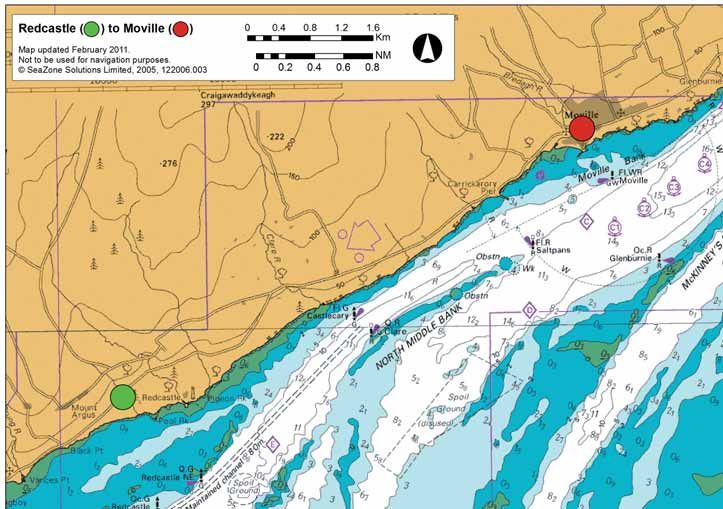
Low lying lands on the eastern shore of Lough Foyle are reclaimed, protected
                                                                                    by the sea wall visible across the water. Much of the land behind the sea
                                                                                    wall is actually below sea level making up polder lands similar to those in the
                                                                                    Netherlands.
                                                                                    There is roadside parking at Culmore and access is via a pebbly beach.
                                                                                    Please do not park on the grassy area above the beach as this will block
                                                                                    slipway access frequently used by emergency services.
                                                                                    Between Culmore and Redcastle, several small streams spill off the Inishowen
                                                                                    hills across deltaic features on the shore (such as at Quigleys Point with its
                                                                                    shop). Stretches of shingle intersperse sand, grading to silt.
                                                                                    Tidal streams reach 2.5 knots along this western shore of the lough and the
                                                                                    river can affect this, if in fl ood.
                                                                                    The pebble beach below the Redcastle Hotel offers a chance to come
                                                                                    ashore for a rest and to avail of some hotel comforts. The hotel welcomes
                                                                                    paddlers coming ashore and up to the hotel.
Section 1: Culmore Point to Redcastle (8 NM)
                  GR: C 477224                    GR: C 554347 & GR C 559349

Culmore Point marks the place where the River Foyle discharges into Lough
Foyle. Culmore village (pub and shop) is a short stroll up the hill.
Culmore translates from Irish as “large corner or nook” and probably refers
to the line of the shore here.
Ships from as far away as south America steam up the Foyle to the Port
of Londonderry. Paddlers should note that ships turn in Culmore Bay and
be aware that the narrow shipping channel runs close to the shore on the
western side of the lough!
Take a look at the old wooden jetties still visible at Lisahally port. This was
the location for the mass surrender of the German U-boat Atlantic fl eet
in 1945 - chosen because of the importance of Derry in the Battle of the
Atlantic when this most northwesterly Allied port sheltered and sustained
the wartime convoy escort ships.
Culmore Point has long been a strategic site. The ancient stone tower was
a Doherty stronghold from medieval times. In 1600, an Elizabethan army
under Dowcra landed here - not unopposed for Dowcra reported that they
were met with a “volie of shot”. The English soldiers fortified this peninsula
and a moat and substantial rampart are still visible, northeastwards along the      • Binevenagh Mountain
shore.

Page 4                                             East Inishowen Sea Kayak Trail   www.loughs-agency.org                                                  Page 5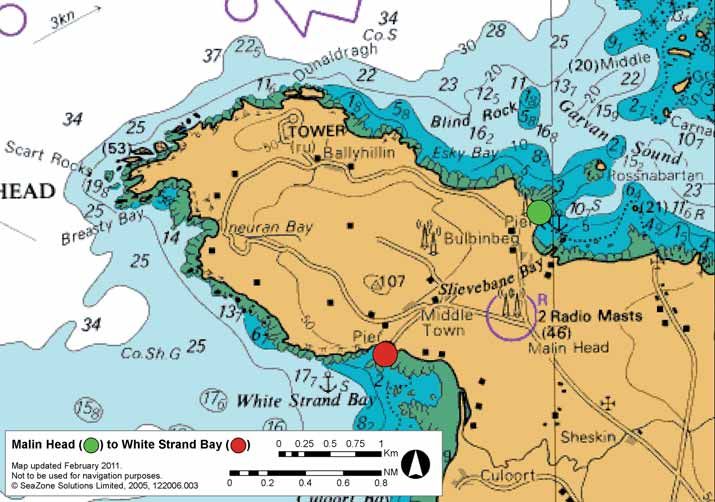
Culmore Point to Redcastle (8 NM)

Page 6
East Inishowen Sea Kayak Trail
www.loughs-agency.org
Page 7

                                 Not to be used for navigation purposes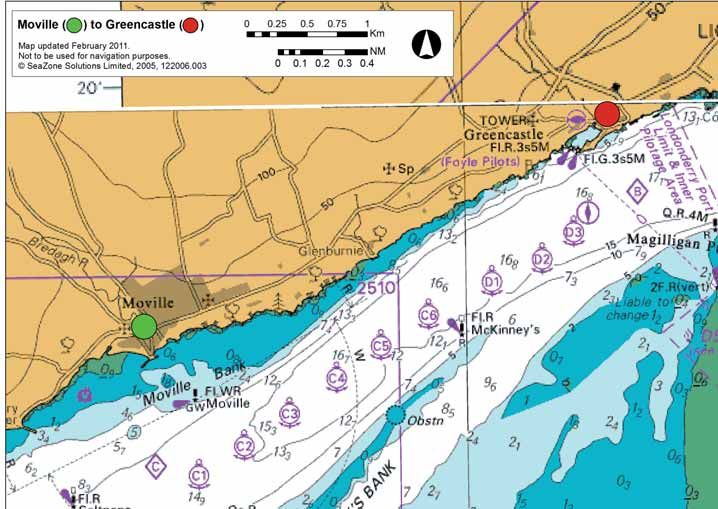
• Moville Harbour

Section 2: Redcastle to Moville (5 NM)
                    GR: C 554347 &    GR: C 611381

                                                                                                                  Not to be used for navigation purposes
                    GR C 559349

The trail from Redcastle to Moville runs past wooded coves and low cliffs.
Watch out for the quite spectacular high arch of the road bridge southwest
of Carrickarory, the fishing pier a kilometre or more short of Moville harbour.
Black Guillemots - pretty with their red legs, black plumage and white wing
bars - nest in cavities in the stonework of the pier.
Along this shore streams run at 2.5 knots.
Across the lough are the rounded hills of the Sperrins, mountains drained
by the rivers Faughan and Roe which spill into Lough Foyle. Just north of
the Sperrins is the plateau of Binevenagh, formed millions of years ago as
lava erupted across the ancient tertiary landscape, slumping to create the
distinctively stepped profi le.

Page 8                                          East Inishowen Sea Kayak Trail   www.loughs-agency.org   Page 9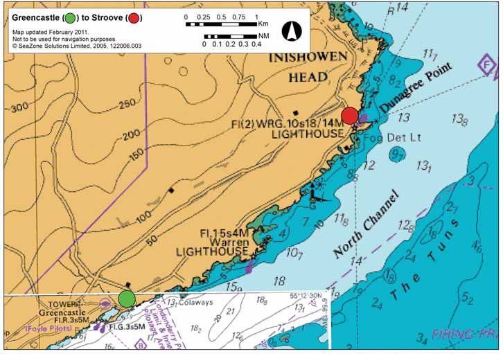
• Moville to Greencastle
  shore walk

        Section 3: Moville to Greencastle (3 NM)
                           GR: C 611381     GR: C 648400

        Moville is an attractive Victorian seaside resort and fishing harbour. The usual
        services (shops, cafes, pubs, accommodation) can be found in this small town.
        In addition to the 2 public slipways in the town (one in the main harbour and
        another beside the old pier with a sculpture on it), the Just Kayak slipway offers
        direct access to a host of facilities including camping, showers, toilets, fresh
        water and secure boat storage. The slipway is managed by Just Kayak and prior
        arrangement is recommended - Web: www.justkayak.ie
        Telephone: + 353 (0) 87 2202 577 or +44 (0) 77 52 194414.
        From Moville, a pleasant wooded landscape and series of rocky offshore reefs
        leads to Greencastle, a busy fishing port with a seafood restaurant, bars and
        shop. A lovely shore side walking trail runs between Moville and Greencastle.
        The paddler will find several sandy coves where they can pull ashore such as
        the convenient picnic site at GR C629389

                                                                                                                               Not to be used for navigation purposes
        The streams in the entrance to Lough Foyle run at 3.5 knots at springs.
        Across the Narrows is Magilligan Point with its Martello Tower, built to defend
        the Foyle from French invasion when Napoleon’s army threatened! A matching
        tower lies opposite in Greencastle close to the ruins of the Norman castle.
        A cosy pub and restaurant offers a welcome at the Point and the Shackleton
        Aviation Museum tells the story of the areas World War Two air bases.
        There is a slipway in the eastern corner of Greencastle harbour, as well as the
        large slipway at the ferry terminal. A superb fish restaurant is nearby and the
        visitor should take a look around the Inishowen Maritime Museum - housed in
        the old coastguard buildings overlooking the harbour.
        Another sea kayak trail is the North Coast Sea Kayak Trail - competent
        kayakers can link up with it at Magilligan Point but plan the crossing of the
        Foyle mouth carefully, studying currents, tide and wind!

         Page 10                                          East Inishowen Sea Kayak Trail     www.loughs-agency.org   Page 11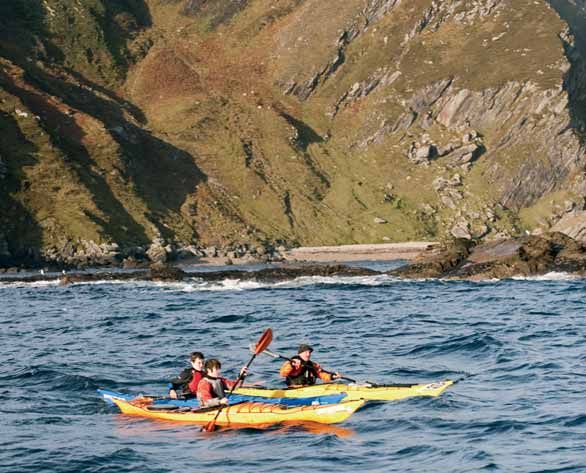
• Inishowen Head Lighthouse

Section 4: Greencastle to Stroove (3 NM)
                  GR: C 648400             GR: C 682428

Greencastle is the second biggest fishing port in Donegal. Trawlers from here
ply the Atlantic as far as Rockall and the harbour is the focus of the Foyle

                                                                                                                    Not to be used for navigation purposes
mussel and oyster industry. This fishing village is set at the mouth of Lough
Foyle, opposite Magilligan Point.
A 3.5 knot current runs at the entrance to the lough at spring tides and a
handy eddy runs on both ebb and flood between the Warren Light and
Moville.
Consider wind and tide on this section - a north to northeast wind against
an ebb tide will raise quite a sea!
The Inishowen Maritime Museum interprets the heritage of the area.
Working northeast along the coast from Greencastle to the peaceful bay
at Shroove (variously spelled Stroove, Shrove) is a delightful paddle past an
interesting mix of secluded coves and low cliffs - the seaside Greencastle Golf
Course must have one of the most idyllic settings of any!

Page 12                                         East Inishowen Sea Kayak Trail    www.loughs-agency.org   Page 13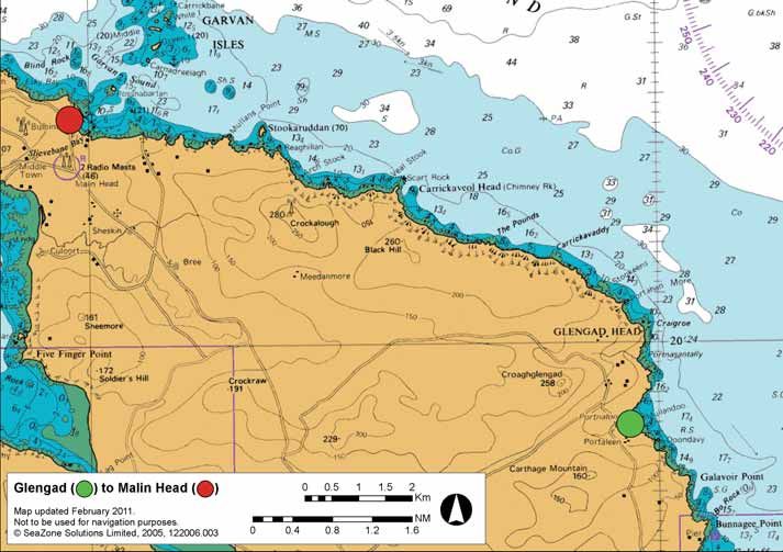
• Inishowen Head Lighthouse

Section 5: Stroove to Kinnagoe Bay (4 NM)
                 GR: C 682428        GR: C 627462
Once one paddles out of the relative shelter of Shroove Bay with its golden
beach and reassuring bulk of the lighthouse, there is no road access to the

                                                                                                                        Not to be used for navigation purposes
shore until Kinnagoe Bay. In planning the trip, consider that a commitment
to paddle for 4 nautical miles is required.
High cliffs, scree and headlands characterise this northeast facing coastline.
There are some places where it is possible to pull ashore but exiting the
shore to land is difficult except at either end of the section.
At Inishowen Head, lookout posts remain from World War Two. Otherwise,
the landscape is unaffected by the hand of man apart from the farmers’
grazing sheep.
Arriving at Kinnagoe Bay (recently voted one of the top ten picnic spots in
Ireland), a golden crescent of sand awaits, backed by dunes. The eastern end
of the beach is a more difficult landing in swell as there are innumerable
boulders and rocks amongst the sand. The western end affords an easier
landing and can be more sheltered when a swell is running.

Page 14                                           East Inishowen Sea Kayak Trail      www.loughs-agency.org   Page 15
• Kinnagoe Bay
Section 6 - Kinnagoe Bay to Tremone (3 NM)
GR: C 627462 GR: C 591476
At Kinnagoe, a Spanish Armada galleon rests beneath the waves. La Trinidad
Valencera sank here in 1588, just 150 metres from the shore at the western
end of the beach. Treasure and other artefacts recovered from the ship are
Not to be used for navigation purposes
on exhibition at the Tower Museum in Derry.
This long, sandy beach is backed by sheltering sand dunes. Around the rocky
promontory at the west end of the beach is a tumbling stream offering fresh
water.
Kinnagoe Bay remains untrammelled by commercial development of any kind
- a beautiful unspoilt beach.
The paddle from here to Tremone is by cliffs and stacks with interesting caves
and tunnels. Look out for some amazingly tightly folded rock strata in the
cliffs!
As with most of the Atlantic shore of east Inishowen there is limited access
to land, with a commitment to paddle for 3 nautical miles.
Page 16 East Inishowen Sea Kayak Trail www.loughs-agency.org Page 17• Bunnagee Harbour
Section 7: Tremone to Culdaff (4 NM)
GR: C 591476 GR: C 540500
This stretch of coastline is generally rocky with some cliffs and a long strand
at Culdaff. A good example of a raised beach can be seen at Tremone Bay
where fertile fields now overlie the once wave cut platform.
Not to be used for navigation purposes
As with other stretches on this trail, there is no road access to the shore
except at the start and finish of the section! Paddlers may find a landing spot
but it will be difficult to move inland - there is a 3 nautical mile paddle from
Tremone to the start of the beach at Culdaff.
A medium size sandy beach at Tremone has road access at its western end,
complete with a small turning area.
At Culdaff Beach, there is good car parking, some dunes and a hotel.
Tremone Bay saw the departure into exile of Thomas D’Arcy Magee, fl eeing
to the Americas after his involvement in the rebellion of 1848.
A key figure in the Young Ireland movement, he later played a leading role
in the confederation of the provinces in Canada, being assassinated there
in 1868 walking home from a late night parliamentary debate (killed, it is
thought, by political opponents).
Page 18 East Inishowen Sea Kayak Trail www.loughs-agency.org Page 19• Glengad
Section 8: Culdaff to Glengad (1 NM)
Not to be used for navigation purposes
GR: C 540500 GR: C 524528
Culdaff town is a 1,500 metre paddle inland along the tidal stretch of the
Culdaff River.
The river separates the sandy beach from the fishing harbour at Bunnagee
with its slipway and pier. The beach at Culdaff gets some good surf in the
right winds.
From Bunnagee to the pier and slipway at Portaleen (or Glengad) the
coastline is cliff girt with, again, no road access and limited landfall for
1 nautical mile. Ancient promontory forts occupy headlands, high above.
Many islanders from Inishtrahull, 10 kilometers offshore, settled in the
Glengad area in the 1920s.
Page 20 East Inishowen Sea Kayak Trail www.loughs-agency.org Page 21• Stookaruddan
Section 9: Glengad to GR: C 524528
Portmore (Malin - east) (7 NM) GR: C 423585
Not to be used for navigation purposes
From Glengad to Malin Pier, the high hills of Inishowen are beaten by the
Atlantic, creating a rugged, isolated coastline bounded by cliffs rising to 230
metres.
Two thirds away along this section, the majestic bulk of cliff bound
Stookaruddan offers island sanctuary to nesting auks. A strong tidal stream
runs off Stookaruddan – but an eddy and shelter from wind and swell is
found between it and the mainland.
After Portaleen, the next road to meet the shore is east of Malin harbour
(a 6 nautical mile paddle) at the “Wee House of Malin”, a religious shrine
occupying the site of a small early Christian ecclesiastic settlement.
The “Wee House” itself is a cave close by.
Above the shore between here and Portmore is a road that passes a shop,
pubs and restaurant.
Page 22 East Inishowen Sea Kayak Trail www.loughs-agency.org Page 23• Malin Head
Section 10: Port More (Malin - east) GR: C 423585
to Port Ronan (Malin - west) (5 NM) GR: C 406572
Hereabouts, currents from the Atlantic Ocean meet tides spilling out of
the Irish Sea to create challenging seas! This section is only for extremely
competent kayakers and those led by very experienced guides. Tides run at
3 knots around Malin Head and complex streams characterise this water!
The Malin Head area is fascinating: the crab fishing harbour at Portmore
(or Malin harbour) where crabs fished a day’s sail away are landed; the
quieter Portronan (on the western side of the ‘Malin peninsula’); Banba’s
Crown (the little islet separated from the mainland by a narrow chasm and
the most northerly point in mainland Ireland); the 19th century watch tower;
and Malin Head itself!
This fantastic stretch of coastline offers towering stacks, rocky reefs, cliffs,
gullies, pebble beaches, raised beaches and, across Garvan Sound, the
mysterious Garvan Isles.
The perfect isle of Inishtrahull, ladylike across 5 nautical mile of ocean, is
Not to be used for navigation purposes
Ireland’s most northerly inhabitable piece of land but the Torr Rocks jut out
of the waves even a little further north again!
The tower surmounting the hill near Malin Head is known as Lloyds Tower.
Built long ago as a lookout to warn of a much feared French invasion, Lloyds
established a signal station here to receive and transmit semaphore - later
radio - messages from ship to shore. Another station was where the modern
lighthouse is on Inishtrahull, extending the effective range of the signalling
system.
Signals could be telegraphed from Malin Head to Lloyds of London, reporting
on the safe arrival of a valuable trans-atlantic cargo. Other news, too, was
transmitted - it is recorded that Malin Head signal station was the fi rst place
in Europe to receive the news of the California Gold Rush in 1848 and word
of President Lincoln’s assassination!
Page 24 East Inishowen Sea Kayak Trail www.loughs-agency.org Page 25The rocks on Inishtrahull are a form of gneiss that is the oldest rock found
in Ireland. Some say a similar rock is found in Greenland and point to this as
evidence that this land was once joined to land that now lies far across the
ocean.
In winter, a flock of barnacle geese fly to this remote island to roost, safe
from land predators, having grazed on Malin Head during the day.
Other wildlife includes red deer, the remnants of a herd that was once
farmed here.
Section 11: Inishtrahull and the Garvan Isles • Inishtrahull Island
GR: C 484653 GR: C 436602
These islands and the seas around them can be misleadingly serene.
Only extremely competent kayakers or those paddling with very
experienced and appropriately qualified leaders should venture here.
The Garvan Isles are a group of rocks and stacks off Malin Harbour. Strong
tidal streams rip through Garvan Sound and the Atlantic swell is forced up
into towering breakers just west of the isles.
Most of the reefs and stacks have evocative names - Lackgolana,
Rossnabartan, Carnadreelagh... .
Inishtrahull is 5 nautical miles to the north, a jewel in these Atlantic waters.
There is a well close to the rocky natural harbour on the northeast side of
the island. Ruins of cottages and a schoolhouse occupy the lower lying land.
A walled lighthouse compound (including the stump of the original
lighthouse) is on the easternmost of the two hills that characterise the island.
Nearby, a small graveyard bears the mortal remains of islanders. Above the
western cliffs is the modern lighthouse.
Tope - caught by anglers
in the waters around
Inishtrahull.
Page 26 East Inishowen Sea Kayak Trail www.loughs-agency.org Page 27Inishtrahull and the Garvan Isles
Page 28
East Inishowen Sea Kayak Trail
www.loughs-agency.org
Page 29
Not to be used for navigation purposesWinds
Remember that Lough Foyle can become choppy, particularly if wind
is against tide.
Treat Lough Foyle as the sea - it is, after all, a large enclosed bay on the
Atlantic coast, reaching 15km width in places!
Much of the kayak trail is along an Atlantic coast, exposed to the east
• Malin head and north.
Tides, winds, and sea conditions generally must be considered in planning
Useful Maps and Guides a trip.
Irish Cruising Club “East and North Coasts of Ireland Sailing Directions” Safety
ISBN 978 0 9558 199 1 9 (excellent information on tides, tidal streams and
navigation points) Kayaking is an adventure sport and, as such, should be treated with respect.
If you are new to the sport, it is advisable to contact a Canoe Association of
OSNI Discoverer Series: sheet 4, 7 Northern Ireland (CANI) or Irish Canoe Union (ICU) approved provider or
Ordnance Survey Ireland: sheet 3 club where expert coaching can be provided.
Admiralty Chart no 2510, 2811 When paddling on the trail consider the following safety advice:
• There are extensive mud flats in Lough Foyle - please be aware that some
Tidal Information access points are best used at high water only.
• Tide tables are available for Lisahally (near mouth of River Foyle) from the • The river is a spate river with a huge and wide catchment - watch out for
Port of Londonderry: www.londonderryport.com flood debris such as trees.
Approximate Time Differences HW/LW and Tidal Characteristics • The Port of Londonderry shipping channel (maintained depth 8 metres)
is a short distance offshore on the Donegal side. It is marked by port and
• Moville - 00:45 starboard hand pile beacons flashing red and green. Depth reduces rapidly
• Londonderry/Derry city +00:35 either side of this often busy channel. Small vessels (including canoes/
kayaks) should be aware of the limitations and needs of larger craft that
• Tidal range: up to 3.08m at Lisahally are restricted to this channel.
• Average flood time (Lisahally): 6 hours 7 minutes • The lough and lower reaches of the river are sailing and boating
• Average ebb time (Lisahally): 6 hours 17 minutes recreational areas and you should be aware of other users, especially sailing
boats competing in races.
• Streams in the entrance to Lough Foyle run at 3.5 knots at springs
• Wear an approved buoyancy aid at all times. Canoe buoyancy must be
• Streams between Moville and Culmore reach 2.5 knots
sufficient to keep the canoe afloat if you capsize.
• The river runs on average at 4.5 knots
• Take care where wind is against tide producing short, steep waves
Page 30 East Inishowen Sea Kayak Trail www.loughs-agency.org Page 31• Wear adequate clothing.
Prolonged immersion in cold
Earning a Welcome
water leads to hypothermia - 1. Please be friendly and polite to local residents and other water users.
hypothermia can kill. 2. Drive with care and consideration and park sensibly.
3. Change clothing discretely, preferably out of public view.
• It is not recommended to 4. Gain permission before going on to private property.
canoe alone.
A group of three paddlers 5. Minimise your impact on the natural environment and use recognised
is the minimum recommended access points. There are many unofficial access points which could be used
number to be safe. with the owner’s consent.
6. Be sensitive to wildlife and other users regarding the level of noise you
• You do not need to be a strong swimmer but you will need water
create.
confidence to deal with a capsized boat and get ashore safely.
7. Observe wildlife from a distance and be aware of sensitive locations such
• Consider attending a training course which covers safety and awareness as bird nest sites, bird roosts, seals on land and wintering wildfowl and
of all types of canoe and kayak and environmental issues. wader concentrations.
• Carry and know how to use tide tables, map, chart and compass. 8. Follow the principles of ‘Leave No Trace’. For more information visit:-
• Obtain an up-to-date weather forecast. www.leavenotraceireland.org
• It is recommended that paddlers leave details of their route with the 9. Keep the numbers in your party consistent with safety, the nature of the
coastguard and another responsible adult. water conditions and the impact on your surroundings.
10. Biosecurity: paddlers must help stop the spread of invasive species
• Carry adequate basic safety equipment - spare clothes, extra food, warm threatening our waterways and coasts! Wash and thoroughly dry boats,
drink, bivvi bag, compass and means of communication (waterproofed VHF paddles and all other kit after a paddle. Desiccation is effective against
radio or mobile phone, fl ares etc), first aid kit. Remember - a canoe may most invasive species, countering their serious environmental and
be difficult to see from a larger craft so carry a whistle and torch / strobe economic impacts.
light.
Shipping Information Canoeists and Anglers
BBC Radio 4 (198 KHz AM in The Foyle river system is a fantastic salmon and wild brown trout fi shery and
Irish waters) broadcasts a shipping angling (including sea angling) is an important element of the rural economy,
Emergency forecast four times a day - attracting many tourists to the area.
00:48hrs, 05:20hrs, 12:00hrs Paddlers are asked to afford anglers the customary courtesies. Take special care
Numbers and 17:55hrs. when approaching wading anglers. If you see someone fishing, consider how you
Dial 999 can pass them with minimal disturbance.
for police, ambulance and Sea area Malin covers the Foyle and
Inishowen.
coastguard Accommodation
A range of self catering, B&B and hotels are available along the trail.
For a full list of accommodation providers please visit:-
www.visitinishowen.com www.discovernorthernireland.com
Page 32 East Inishowen Sea Kayak Trail www.loughs-agency.org Page 33• Malin pier
Further Information
Tourist Information Centres:
Inishowen Tourism: +353 (0)7493 62602 www.visitinishowen.com
Derry Visitor Convention Bureau: +44 (0)28 7137 7577
www .derryvisitor.com
Trail updates - any changes will be updated on www.loughs-agency.org
Canoe Trails: www.canoeni.com
The Canoe Association of Northern Ireland: www.cani.org.uk
Outdoor NI: www.outdoorni.com
Countryside Access & Activities Network :
www.countrysiderecreation.com
Loughs Agency: www.loughs-agency.org
Acknowledgements: Gardiner Mitchell Photography and all the valuable • Hitching a ride!
advice from CANI, CAAN, SportNI, Just Kayak,
National Parks and Wildlife Service, Inishowen Tourism,
Londonderry Port, Inishowen Boating and Limavady
Borough Council.
Disclaimer:
Every effort has been taken to ensure accuracy in the compilation of this
publication. The Loughs Agency and its partner organisations cannot, however,
accept responsibility for errors or omissions but, where such are brought to
our attention, future publications will be amended accordingly. Kayaking may,
by its nature, be hazardous and involve risk. It is recommended in such cases
to take out personal accident insurance and any appropriate liability cover.
Users must undertake and act on their own risk assessments prior to use of
any site or waterway and review and update during use. The guide must be
used in conjunction with an ordnance survey 1:50,000 map and an accurate
navigation chart. Neither the publishers, funders, contributors, landowners,
site managers, riparian owners nor agents of the aforementioned can be held
responsible for any loss, injury or inconvenience sustained by any person or
persons as a result of information, guidance or advice given in or omitted
from this guide.
Page 34 East Inishowen Sea Kayak Trail www.loughs-agency.org Page 35Northeast Inishowen
Page 36 East Inishowen Sea Kayak Trail• northeast Inishowen
Navigation and Safety Points
Lough Foyle is a shallow bay with
a deep but narrow entrance.
When passage planning, study
tides, pilot books and weather
forecasts carefully and take into
account the effect of streams,
eddies, races and overfalls!
Think of wind speed and
direction - even the lough can whip p up rough,
                                    ly winds and the changeable Atlantic
particularly in easterly and southerly
elements must always be respected!
A narrow, busy shipping channel runs along the western side of the lough.
Paddlers must plan their course to avoid maritime traffic - for instance,
stay outside and to the west of the shipping channel (marked by port and
starboard hand pile beacons, flashing red and green).
Steer a wide berth from the commercial shipping facilities on the opposite
shore from Culmore: Lisahally port, oil and chemical jetties near Maydown
and the power station with its water intake and discharge.
Fishing boats dredge for shellfish in the shallow lough, executing tight turns
when fishing. Take care - busy crew can easily overlook a canoe or kayak!
Avoid metal oyster cages and trellises along the shore (may not be visible at
high water).
Wear bright clothing and always wear a serviceable buoyancy aid.
Date of Publication: December 2011
Copyright © 2011 Loughs Agency
This document is made available free of charge by the Loughs Agency

                        Loughs Agency
                        22 Victoria Road
                        Londonderry / Derry
                        BT47 2AB
                        Tel: + 44 (0) 28 7134 2100 (from ROI 048 7134 2100)
                        Fax: + 44 (0) 28 7134 2720
                        Email: general@loughs-agency.org
                        Web: www.loughs-agency.org

                                                                      DMS 11.12.147
You can also read