EBee X Map without limits - senseFly
←
→
Page content transcription
If your browser does not render page correctly, please read the page content below
eBee X
Map without limits
eBee X
You don’t compromise in the field - neither should your drone.
Up to 90 minutes flight time*
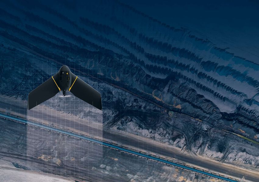
The eBee X is our most advanced fixed-wing drone that’s Capture more - efficiently cover up to 500 ha (1,235 ac)
designed to meet all your surveying and mapping needs. while flying at 400 ft.
Whether your project site is small or vast, straightforward or
complex, the eBee X goes the distance while helping you boost
the quality, efficiency and safety of your data collection.
Down to 1.5 cm high-precision accuracy
Available RTK/PPK allows you to achieve the absolute accuracy
your project requires, without GCPs.
Unmatched versatility
Compatible with more than seven sensors, eBee X is capable
of getting the job done no matter the requirements.
Lightweight and durable
Designed to operate in the harshest conditions, thanks to its
optimized airframe and ultra-tough under-body skin.
Safe and easy to use
“I immediately felt comfortable flying the eBee X and Simply plan your mission. Launch the drone and collect critical
the senseFly Aeria X is a phenomenal mapping project data in minutes.
camera. As for that material on the body,
I can’t believe how strong that stuff is!”
Scott Hiebert, CEO, Green Aero Tech *Referenced flight time achieved with endurance battery and S.O.D.A. sensor.
Light, robust and efficient. The first camera built specifically for
                                                                   S.O.D.A.     professional drone photogrammetry. Offers the greatest flight time.

SUITS
EVERY
                                                                                Generate stunning 3D reconstruction or increase your coverage
                                                                  S.O.D.A. 3D   to 500 ha with this unique photogrammetry sensor that changes
                                                                                orientation during flight to capture nadir and oblique images.

MAPPING                                                            Duet T
                                                                                Create high-resolution, geo-accurate thermal maps, reliably, on
                                                                                demand.

JOB                                                                Aeria X
                                                                                For those who demand the highest quality RGB outputs.
                                                                                The senseFly Aeria X is a compact photogrammetry powerhouse.

                                                                                senseFly Duet M is an innovative dual-purpose RGB and
                                                                   Duet M       multispectral mapping camera. Use it to create geo-accurate
                                                                                multispectral maps and digital surface models quickly and easily.

                                                                                This multispectral crop camera captures imagery across four
                                                                                spectral bands, plus RGB. It features automatic radiometric
                                                                  Sequoia+      calibration for consistent measurements and is RTK/PPK
                                                                                compatible for precise georeferenced results.

From surveying mines and complex construction sites to
crop health analysis and disaster response, the eBee X is
suited for any job thanks to its wide-range of groundbreaking,                  The MicaSense RedEdge-MX is a rugged and professional

interchangeable cameras.                                         RedEdge-MX
                                                                                multispectral sensor. It captures the spectral bands required
                                                                                for basic crop health indexes and additional bands needed for
                                                                                advanced analytics.
Learn more about our camera on our website
www.sensefly.com/cameras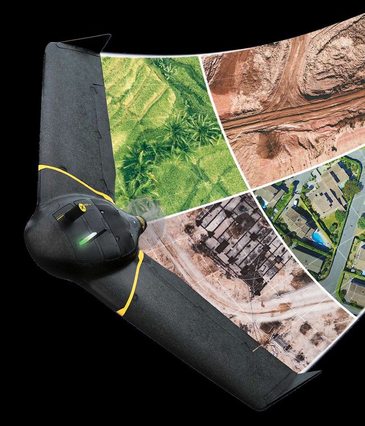
How it works
                                              Version 3 | Compatible with
                                               Windows 8 and 10 | 64-bit

                                                                            With eMotion, flights are built using mission blocks. Just choose your block, highlight the region you want to map,
                                                                            define key settings, and eMotion auto-generates your drone’s flight plan. Multi-flight missions are supported and
                                                                            you can activate/import elevation data for even safer, terrain-accurate flights.

Beginner-friendly, yet packed with advanced features to tackle
the toughest jobs, our eMotion flight planning software optimizes
every step, helping to get your eBee X in the air quickly and with
ease, so you can focus on what’s important - collecting and
analyzing site-critical geospatial data.
                                                                                                                                                                          Processed with Pix4D

“A drone’s flight management software defines                               Upload your flight plan wirelessly to your drone. After   eMotion’s built-in Flight Data Manager automatically
                                                                            a simple hand launch, your eBee X drone will then fly,    handles the georeferencing & preparation of images
your experience—if this is complicated or confusing,                        capture images and land by itself.                        required for post-processing in software such as
operations can quickly become a chore. eMotion is                                                                                     Pix4Dmapper.

different: it’s advanced, scalable drone software that                      Compatible photogrammetry software

anyone can use.”                                                                 Pix4Dmapper/Pix4DCloud/Pix4Dmatic/Pix4Dfields, Agisoft PhotoScan, Esri Drone2Map,
                                                                                 DroneDeploy, Trimble Business Center and Bentley ContextCapture
Scott Hiebert, CEO, Green Aero Tech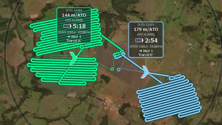
Reduce downtime and
maintenance costs
The eBee X was designed to
reduce both delays and repairs
thanks to its modular design
that lets you swap out parts, as
needed.

                                    Upper Body       Payloads

                 Lower Body                                             Pitot Tube

                                                                     Maintenance made easy
                                                                     Get your senseFly drone
                                   Autopilot Stack   Clipped Wings   serviced locally, thanks
                                                                     to our global network of
                                                                     authorized service centers.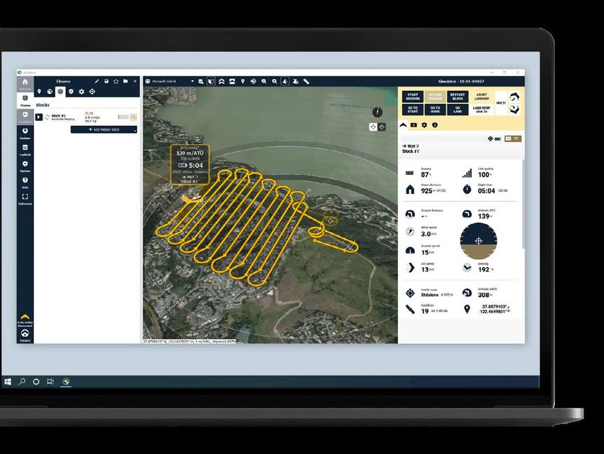
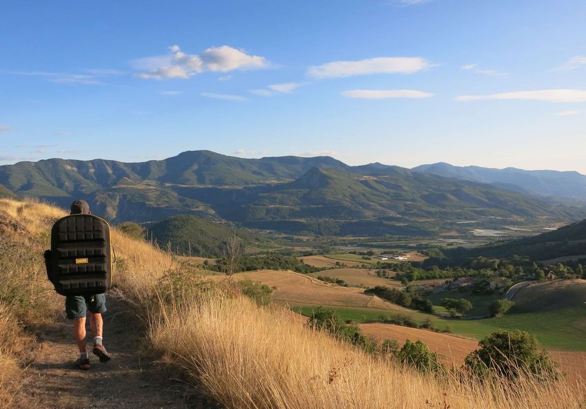
All you need to survey with your eBee X.
On your back.
The eBee X backpack is a smart and durable way to carry
everything you need to transport your new senseFly drone
into and out of the field.

                                                                            All your gear in one spot
                                                                            Safely store and transport everything you need
                                                                            to operate your eBee X.
                                                             Est-ce qu’on utilise cette image ou est-ce qu’on réunis quelques
                                                             facts qui englobent la situation dans les différents pays ? (le
                                                             poinds, l’altitude,...)

                                                                                        Lightweight and durable
                                                                                        Comes with a rain cover to ensure your
                                                                                        drone stays protected from the elements.

                                                                           Laptop pocket
                                                                           The eBee X series backpack features a helpful
                                                                           45 cm x 45 cm (17.7 in) laptop pocket

                                                           Comfort and security
                                                           Ergonomic and adjustable straps help keep you comfortable
                                                           while transporting your drone.
The senseFly eBee X                                      Go further, fly longer
   comes with...                                            with senseFly accessories
                                                                                 Remote Control                      GeoBase
                                                           Operate your eBee X drone manually                       Enable high-
                                                             with the available remote control                     accuracy workflows
                                                                                                                   with this plug-
                                                                                                                  and-play GNSS
1x eBee X Drone                                                                                                  instrument

                                                                                                                 Spare Pitot Pro Kit
                                            1x Backpack                      USB Ping                            Contains 3 spare pitot tubes.
                                                                   View live air traffic                        The pitot tube is used by
                                                                 data directly within                          the eBee X to measure wind
                                                                           eMotion                            speed and direction for course
                                                                                                             correction as well as landing
      2x Spare Propellers
                                                                                                            optimization
     10x Spare Propelller
     attachment rubber
                bands                                                               Radio Tracker
                                                                               Safeguard against
                                                                                                                        RTK / PPK Activation
                                                                             unexpected aircraft
                                                                                                                        Achieve absolute
                                                                      signal loss while flying in
                                                                                                                       accuracy of down to
                                                                    high winds, mountainous
                                                                                                                      1.5 cm (0.6 in) with
                                                                    areas or very large areas
           2x Lithium-Polymer         1x Lithium-Polymer                                                             available RTK/PPK
           Standard Batteries                                             out of line of sight
                                      Battery Charger

                                                                         Endurance Battery
                                                                                                                  Endurance Extension
                                                                      Available Endurance
                                                                                                                  Fly up to 90 minutes
                                                                        Batteries allow for
                                                                                                                 in a single flight
                                                                 flight times of up to 90
                                                                                                                (Endurance Battery
                                                                                minutes
                                                                                                               required)

     1x Spare Pitot Kit           1x USB Ground Modem

                                                               Extended Warranty
                                                                                                          Hard Case
                                                                 1-year warranty
                                                                                                          For extra protection in
                                                                      extension
                                                                                                         harsh environments

                   1x USB Cable
                To connect your
                                                                                                    Certified Operator Program
         computer to the drone                                                                      www.senseflyacademy.com
           and some cameras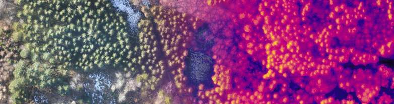
Real-Time Kinematic (RTK)
Accuracy is the measure of success.                                                                                 Real-time kinematic is a technique used to enhance the precision of position data derived from satellite-based

Get the most out of eBee X                                                                                          positioning systems, which relies on a single reference station or interpolated virtual station to correct geotagged
                                                                                                                    locations while in flight. In other words, RTK is a correction method that enhances GNSS precision.

with active RTK/PPK                                                                                                 RTK is advantageous for many surveying professionals because it increases safety. The technique eliminates
                                                                                                                    the need for teams to maneuver through dangerous terrain to set GCPs while also efficiently saving time and
                                                                                                                    productivity. RTK provides corrections to the drone onsite and is ideal for geo-tagging in absolute accuracy
                                                                                                                    throughout flights in real-time. No GNSS post-processing is necessary with real-time correction.

                                                                                                                    This technique does require a base station and a consistent connection to process data in real-time. While
                                                                                                                    this extra piece of equipment provides the benefit of increased accuracy, it also has a moderate possibility of
                                                                                                                    malfunctioning.

A surveyor’s job is to capture accurate data. With boots on the ground, this
                                                                                                                    The RTK methods work well in flat terrain where trees or mountains won’t get in the way of the communication
responsibility is almost entirely up to the surveyor and their level of expertise                                   signal. RTK is restricted by the power ofground and air communication with the drone. If there’s more than three
with the equipment and jobsite. The eBee X is an advanced drone platform that                                       kilometers between the drone and the ground station, or if there are obstructions such as trees or mountains,
                                                                                                                    there’s a chance it will lose signal.
makes your surveying process faster, safer and more efficient.
                                                                                                                    As an operational best practice, it’s ideal to use RTK on flights in open terrain and within two or three kilometers
                                                                                                                    of the ground station to maintain the communications link. These flights can deliver highly accurate results
                                                                                                                    without the need for using GCPs. This is an extremely helpful advantage for land surveyors working in dense
                                                                                                                    vegetation, crops and other hard to distinguish terrain.
While laying ground control points (GCPs) has been a necessary step in drone surveying workflows from the
beginning, advancements in GNSS technology have led to the evolution of real-time kinematic (RTK) and               Post-Processing Kinematic (PPK)
post-processing kinematic (PPK) methods. Each of these methods have their own benefits and can improve
drone pilot workflows. The following is a quick look at the use of GCPs and the added benefit of active RTK/        An alternative method to RTK is post-processing kinematic. This kinematic technique corrects geotag
PPK.                                                                                                                accuracy after capturing and uploading drone data. The data is corrected in the flight data manager and
                                                                                                                    then processed in the cloud. PPK also offers a safety advantage because similar to RTK, the technique
Ground Control Points (GCPs)                                                                                        eliminates the need for teams to maneuver through dangerous terrain to set GCPs. Also, there’s an even greater
                                                                                                                    timesavings in comparison to RTK-to-GCP because less time is spent on-site preparing the RTK connection.
A Ground Control Point is a location or object on the ground that has precisely known coordinates. GCPs are
used to accurately geo-reference and align projects from relative accuracy—one to two meters—to absolute            Setup is easier because no cable or Bluetooth connection is required with thebase station. PPK is more
accuracy—two to five centimeters.                                                                                   dependable than RTK because it does not depend on signal strength or GNSS information from the base
                                                                                                                    station in real-time.
This method has been used for years and trusted to consistently produce a high level of precision and overall
accuracy. In addition, GCPs allow the production of defensible quality report to prove the validity of technology   This method offers more flexibility in flight since a connection isn’t required for data capture however,
and are used for consistent ground truthing of a project’s accuracy.                                                additionalprocessing time will be needed post-flight to georeference the data. The PPK method is ideal for
                                                                                                                    longer flights, especially BVLOS missions. The longer the flight, the greater chance there is of losing signal to the
There are some downsides however, as GCPs can take as much as four timeslonger to setup in comparison to            connection needed for RTK.
RTK and large worksites may require an entire crew to set points. This can be a dangerous endeavor in certain
environments and may require additional equipment including a GPS rover, base, VRS network license in addition
to the spray paint and targets.
                                                                                                                    In Summary
GCPs have been a proven method of accuracy for years, but with safer and faster methods available, it should
                                                                                                                    When considering factors such as ease of use, time and expense, the advantages of an RTK/PPK-enabled drone
be used only when RTK and PPK are not possible.
                                                                                                                    become more apparent. Difficult terrain, unreachable spots and safety concerns can be deterrents for using
                                                                                                                    GCPs, not to mention the amount of time it could take to plan and measure each. The integration of GNSS
                                                                                                                    technology within the drone industry has helped improvethe workflow of drone pilots by making mapping
                                                                                                                    missions more accurate, efficient, cost-effective and —most importantly—safe.
Hardware Datasheet Battery Standard Endurance Radio Link
eBee X Power 3700 mAh 4900 mAh Certification CE or FCC
Wingspan 116 cm (45.7 in) Voltage 15.2V 15.2V Range 3 km nominal (up to 8 km)
4 Cell / 1.9 mi (up to 5 mi)
Material Expanded Polypropylene (EPP) Number of cells 4 Cell
LiHV Frequency 2.400 - 2.4835 GHz
Underbody skin Curv® Polypropylene thermoplastic composite Type LiHV
74.48Wh Encryption AES 254 Available
Weight (Empty) 0.8 kg Energy 56.24Wh
420g EIRP CE/JP 20.0 dBm max
Max Take-off weight 1.6 kg Weight 330g
FCC 22.5 dBm max
Backpack dimension 75 x 50 x 29 cm (29.5 x 19.7 x 11.4 in)
Motor Low-noise, brushless, electric How long can you fly with your eBee X?
Detachable wing Yes
Empty backpack weight 4.6 kg
Camera
senseFly S.O.D.A. & Standard Battery
Coverage & accuracy S.O.D.A. Corridor Endurance Battery
Nominal coverage at 122 m (400 ft) 220 ha (550 ac), with senseFly S.O.D.A. and without
Standard Battery
Endurance Extension senseFly S.O.D.A. 3D
Endurance Battery
Max. nominal coverage at 122 m (400 ft) 500 ha (1,235 ac), with senseFly S.O.D.A. 3D and with
Endurance Extension Standard Battery
senseFly Aeria X
Endurance Battery
Ground sampling distance at 122 m (400 ft) 2.5 cm/px (1.0 in/px), with senseFly Aeria X
Lowest ground sampling distance 1,0 cm/px (0.4 in/px) with senseFly Aeria X Standard Battery
senseFly Duet T
Endurance Battery
Absolute X, Y, Z accuracy (RTK/PPK activated) 1.5 cm (0.6 in)
Standard Battery
senseFly Duet M
Flight performance Endurance Battery
Cruise speed 40-110 km/h (11-30 m/s or 25-68 mph)
MicaSense Standard Battery
Max wind resistance Up to 46 km/h (12.8 m/s or 28.6 mph) RedEdge MX Endurance Battery
Landing type Linear landing Standard Battery
(5 m/16.4 ft accuracy in 20° angle cone) Parrot Sequoia
Endurance Battery
Service temperature -15° to 40°C *
Flight time 0 10’ 20’ 30’ 40’ 50’ 60’ 70’ 80’ 90’
in minutes
Humidity Light rain resistance
Ground avoidance Yes - LiDAR (range 120m)
Automatic safe return when the battery is low
High Precision
Mission Low endurance Low battery
Upgradable on demand Yes
RTK Virtual Base Station, Base Station Unknown point, The drone is performing 15% and below is enough Below 10%, it is no longer possible
Base Station Known point its mission and capturing to return Home and land. to continue the mission. The drone
images returns home to land.
PPK Yes
GNSS GPS+GLONASS
Maintenance and service
Spare Parts Available Pitot Tubes, Wings, Propellers and vertical surfaces
100% 15% 10% 0%
Modular Repair Auto Pilot Stack, Upper Body and Lower Body
Service Every 100 flight hours
The above figures represent optimal flight conditions. It is not representative of all flight times and will vary depending on flight conditions.
Also note that the condition of the pitot tube can influence flight time. Flights longer than 60 minutes require Endurance Activation.
*Working above 35°C / 95°F requires to protect the drone from the sun while on the ground **Max. coverage figures based on eBee X flight over flat terrain, in optimal conditions, using a senseFly S.O.D.A. 3D camera.
You don’t compromise in the field -
                    neither should your drone.

The eBee X is our most advanced fixed-wing drone that’s designed to meet all
your surveying and mapping needs. Whether your project site is small or vast,
straightforward or complex, the eBee X goes the distance while helping you
        boost the quality, efficiency and safety of your data collection.

senseFly believes in using technology to make work safer and more
efficient. Our proven drone solutions simplify the collection and analysis
of geospatial data, allowing professionals in surveying, mining, agriculture,
engineering, environmental monitoring and humanitarian aid to make better
decisions, faster. senseFly is a commercial drone subsidiary of Parrot Group.

                  senseFly SA             senseFly Inc.
            Route de Genève 38            Raleigh
    1033 Cheseaux-sur-Lausanne            North Carolina
                    Switzerland

                +41 21 552 04 40          +1 919 917 9602

                            www.sensefly.com
                            info@sensefly.com                                   EN V1 2021
You can also read