Effective Visual Place Recognition Using Multi-Sequence Maps
←
→
Page content transcription
If your browser does not render page correctly, please read the page content below
IEEE ROBOTICS AND AUTOMATION LETTERS. PREPRINT VERSION. ACCEPTED JANUARY, 2019                                                                1

               Effective Visual Place Recognition Using
                         Multi-Sequence Maps
                                                Olga Vysotska and Cyrill Stachniss

   Abstract—Visual place recognition is a challenging task, espe-
cially in outdoor environments as the scenes naturally change
their appearance. In this paper, we propose a method for visual
place recognition that is able to deal with seasonal changes,
different weather condition as well as illumination changes. Our
approach localizes the robot in a map, which is represented
by multiple image sequences collected in the past at different
points in time. Our approach is also able to localize a vehicle in
a map generated from Google Street View images. Due to the
deployment of an efficient hashing-based image retrieval strategy
for finding potential matches in combination with informed
search in a data association graph, our approach robustly
localizes a robot and quickly relocalizes it if getting lost. Our
experiments suggest that our algorithm is an effective matching
approach to align the currently obtained images with multiple
trajectories for online operation.
  Index Terms—Localization, Visual Place Recognition
                                                                         Fig. 1: Given a sequence of query images (black trajectory), our
                                                                         approach is able to localize the robot within multiple reference
                        I. I NTRODUCTION                                 sequences (colored) of different length, shape, and visual appearance.

L     OCALIZATION is a key building block for most robot
      navigation systems, as robots need to know where they
are in order to take navigation decisions. One form of lo-
                                                                         types of changes in the appearance better than when consider-
                                                                         ing single images. Sequence-based approaches, however, often
calization, which is also relevant for performing loop-closing           face the challenge that they must provide means for efficient
within the simultaneous localization and mapping problem,                localization even if the robot has deviated from a previously
is the ability to identify that the robot is currently at a              taken route. Furthermore, the majority of approaches in this
place already observed in the past, also known as ”weak”                 area considers only the matching of two trajectories although
localization. Solving this global data association problem is            there are exceptions such as the experience-based navigation
especially challenging for robots operating in dynamic and               paradigm [6], which can fuse multiple trajectories into a graph
changing environments. A robust localization system should be            combining topological and metric information.
able to deal with the substantial appearance changes that occur
                                                                            The main contribution of this paper is a new sequence-
in real-world outdoor environment due to seasonal change,
                                                                         based visual place recognition system that localizes against
weather, or modifications in the scene, see Fig. 1 for an
                                                                         a map consisting of multiple image sequences. Our system is
example. Thus, the goal of all such localization systems is
                                                                         particularly robust against drastic visual appearance changes
to relate the current observation with respect to a previously
                                                                         due to a combination of expressive image features from a layer
recorded one or a model of the environment.
                                                                         of convolutional neural network with adapted graph-based
   Image matching-based localization, also under substantial
                                                                         search in maps consisting of multiple trajectories of camera
scene changes, is an active research field and multiple ap-
                                                                         images. A property of our new method is that the reference
proaches have been proposed [6], [7], [16], [21], [22]. One
                                                                         sequences can be of arbitrary shape and represent places under
group of approaches relies on sequence information, i.e., they
                                                                         different seasons or weather conditions. Additionally, there are
exploit the fact the images are not recorded in a random
                                                                         no restrictions imposed on the length or amount of overlap
order but according to the motion of the robot or vehicle
                                                                         between the trajectories as well as on synchronization, i.e.,
through the environment. This allows for handling certain
                                                                         the reference trajectories do not need to be image-to-image
  Manuscript received: September, 10, 2018; Revised December, 6, 2018;   synchronized. We address the problem of relocalization by
Accepted January, 3, 2019.                                               deploying a hashing-based image retrieval with the search
  This paper was recommended for publication by Editor Cesar Cadena
Lerma upon evaluation of the Associate Editor and Reviewers’ comments.
                                                                         through a data association graph.
This work has partly been supported by the German Research Foundation       We evaluate our approach on different datasets to illustrate
under Germany’s Excellence Strategy, EXC-2070 - 390732324 (PhenoRob).    the following properties of our approach. First, it can recognize
  The authors are with the University of Bonn, Germany,
olga.vysotska@uni-bonn.de                                                previously visited places within the map of multiple sequences.
  Digital Object Identifier (DOI): see top of this page.                 The map can consist of multiple independently collected
2                                                   IEEE ROBOTICS AND AUTOMATION LETTERS. PREPRINT VERSION. ACCEPTED JANUARY, 2019

sequences or be constructed from the publicly available data,                                   database images

                                                                                 query images
like Google Street View. Second, the sequence can be collected                                                    source
using different setups, e.g., in cars or on bikes. Third, our
matching approach is an online approach, which is fast enough                                   0:                         ...
to be executed on a mobile platform.
                                                                                                 1:                        ...

                     II. R ELATED W ORK
                                                                                                2:                         ...
   Localization in real-world outdoor environments is an active                                             ...            ...
field of research and one popular, image-based approach is                                        :
FAB-MAP2 [7]. In order to deal with substantial variations
                                                                    Fig. 2: Graph structure inherited from [22]. Nodes correspond to
in the visual input, however, it is useful to exploit sequence
                                                                    possible image matches, edges represent transitions between the
information for the alignment, compare [10], [14], [15], [16].      matches. Green circles denote expanded nodes (for which two feature
Another popular approach for visual place recognition pro-          vectors are compared); red circle - match; blue - non match, but
posed by Galvez-Lopez et al. [8] proposes a bag of words            support the path hypothesis.
approach using binary features for fast image retrieval. Or-
thogonal to the exploitation of sequences, different types of
                                                                       Typical approaches to visual place recognition start with
features and their use for place recognition have been studied.
                                                                    collecting the datasets, sequences or experiences to recognize
Some approaches use variants of HOG features such as [16]
                                                                    later on the places against. Collecting these maps is a time and
or Bag of Words models optimized for seasonal changes [17].
                                                                    resource consuming operation. Recently, there started to ap-
More recently, multiple researchers apply learned features such
                                                                    pear several approaches in the literature that tried to overcome
as those proposed by Sermanet et al. [19] and suggested for
                                                                    the burden on collecting the reference dataset by exploiting
place recognition by Chen et al. [5]. These CNN features yield
                                                                    already exciting sources, like Google Street View or other
a high matching quality but are rather high-dimensional, i.e.,
                                                                    publicly available sources. Badino et al. [4] proposed a method
comparisons are computationally expensive. This motivates
                                                                    for long term vehicle localization that can localize a vehicle
the binarizations of such features and efficient comparisons
                                                                    with respect to previously collected topometric map as well
using the Hamming distance [3]. Another recent approach by
                                                                    as Google Street View. Their method deploy local keypoint
Maffra et al. [12] proposes a system for viewpoint tolerant
                                                                    features U-SURF and performs localization and tracking by
place recognition for UAV navigation. This approach uses
                                                                    applying discreet Bayes filter. To implement the state transition
3D structure of the environment obtained from visual-inertia
                                                                    probability function, the authors assume to know the velocity
keyframe-based SLAM to be able to perform robust place
                                                                    of the robot at every point in time, whereas our approach only
recognition in presence of dramatic view-point changes. In
                                                                    relies on maximal possible velocity or in other words maxi-
our approach we proposed pure image based place recognition
                                                                    mum possible distance in frames (fanout). Another approach
without building a 3D map of the environment.
                                                                    by Majdik et al. [13] uses Google Street View to localize a
   The experience-based navigation paradigm [6] takes               micro aerial vehicle. This setup imposes particular viewpoint
into account multiple sequences and stores multiple im-             challenge which they overcome by generating virtual views
ages/experiences for individual places. It extends the place        and match them against the street view images. Agarwal
model whenever matching the current images to previous              et al. [1] also uses the imagery from Google Street View
ones becomes challenging. Extension of experience-based             to perform a metric robot localization. They compute rigid
navigation targets large-scale localization by exploiting a pri-    body transformation between input image stream from the
oritized collection of relevant experiences so that the number      monocular camera and geotagged rectilinear panoramic views.
of matches can be reduced [10]. SeqSLAM [15] aims at                Afterwards, they perform a two phase nonlinear least square
matching image sequences under strong seasonal changes              estimation to obtain the refined robot poses. The authors rely
and computes an image-by-image matching matrix that stores          on an inaccurate GPS to preselect the set of panoramas to
similarity scores between the images in a query and database        perform metric localization against. Our approach can directly
sequence. Milford et al. [14] present a comprehensive study         provide the matching street view image to perform a more
about the SeqSLAM performance on low-resolution images.             precise metric localization.
Related to that, Naseer et al. [16] focus on offline sequence
matching using a network flow approach and Vysotska et
                                                                                                      III. O UR A PPROACH
al. [22] extended this idea towards an online approach with
lazy data association and build up a data association graph         A. Graph-Based Sequence-to-Sequence Localization
online on demand. To not restrict query trajectory to follow          Most related work on sequence matching consider one
the reference one all the time, we proposed in our paper [23]       sequence to localize against. They seek to find for every
an extension that allows for flexible trajectories. To be able      image in a query sequence, e.g. the sequence of incoming
to achieve this flexibility, we proposed an efficient hashing       images, the corresponding image in reference sequence, e.g.
based relocalization strategy as well as how to apply traditional   sequence recorded beforehand. In this subsection, we briefly
hashing based techniques within the graph-search sequence           summarize the main principles of graph-based image visual
matching framework.                                                 place recognition described by Vysotska and Stachniss in [22].
VYSOTSKA et al.: EFFECTIVE VISUAL PLACE RECOGNITION USING MULTI-SEQUENCE MAPS                                                       3

We preserve the sequential information by constructing a                For consistency, we briefly repeat here the relocalization
graph structure, where every node corresponds to the potential       strategy. In previous paper, we proposed a relocalization
match between a pair of images, from query and reference             technique based on the feature dimensionality analysis and
sequences, and the edges represent possible transitions be-          inverted index structure. This method works better and faster
tween the potential matches. Intuitively, the edges show if          than Multi-Probe Locality Sensitive hashing (LSH) [11] for
a pair of images is considered a match, where to look for            very high-dimensional feature vectors, for example features
the next matches, e.g. pair of matching images, see Fig. 2           from OverFeat convolutional neural network [19] or VGG-
for illustration. In some cases due to potentially severe visual     16 [20]. In this paper, we opted for newer smaller feature
appearance changes, for example, caused by glare or occlu-           vectors, namely the feature vectors obtained from NetVLAD
sions, the images that correspond to the same place produce          convolutional neural network [2]. The advantages of these
low matching scores. To compensate for this issue the nodes          features are comparably small size (4092) and robustness
in the graph are represented by two states real (red) / hidden       against visual appearance changes. Due to the vector size,
(blue). A node becomes hidden if the cost of matching two            we selected Multi-Probe Locality Sensitive hashing as a fast
images is higher than predefine non-matching cost m. This            alternative to perform relocalization. Whenever the robot is
preserves the sequential behavior of the search, but discards        lost, defined by the fact that there are more than 80% hidden
visually bad matches. Given the proposed graph structure, the        nodes in the sliding window around current best match, we
correspondence between images is found through the search            pick the top candidates from all the images using Multi-
for the shortest path in the graph. Furthermore, we adapted          Probe LSH and select the most promising one. This matching
the proposed method to operate in online fashion, where for          candidate becomes a real node if the respective matching
every incoming image, we expand only a fraction of the graph         cost is lower than non-matching threshold m and a hidden
following the current best matching hypothesis and update the        node otherwise. Afterwards, we connect it to the current best
search. Due to the ideas of lazy data associations, we are           matching hypothesis. We consider the relocalization to be
able to track multiple hypotheses for the image matchings.           successful if no more than 80% of the nodes within the sliding
For more details, please refer to [22].                              window of 5 frames in path hypothesis are hidden nodes.
   One of the weaknesses of the described approach is its               The novelty of this work is the fact that the map consists
inability to efficiently handle flexible trajectories. We say that   of multiple sequences of the images collected in different
trajectories are ”flexible” if they do not follow the same route.    points in time, recorded from different viewpoints, and with
By using the described above graph construction procedure,           different frame rates. We may synchronize the sequences
we implicitly assume that both image sequences roughly               by performing the pairwise sequence-to-sequence matching,
follow the same physical trajectories. This means that for most      i.e. given our approach described so far, for all reference
of the incoming images there should be an image representing         sequences. From this matching information, we can define
the similar place in the reference sequence. However, in real-       an in-reference matching function M (j, t) that returns for the
world scenarios this is not always the case due to differently       image j from reference trajectory t all images (image index
planned routes or specific map geometry. Typical problems            and trajectory index) that match to image j from t. If there
within flexible trajectories are loops within reference trajectory   are no corresponding images, the function returns the empty
and deviations of the query routes, since both cases violate the     set. To enhance the localizability capabilities of the system,
smoothness assumptions of the search. To tackle this issue,          we have changed the representation of the map in comparison
we have introduced additional edges in the graph structure           to [22] to be able to match against multiple image sequences.
that allows to handle loops within reference trajectories and        To incorporate this map of multiple reference sequences into
proposed an efficient relocalization techniques for finding the      our search procedure, we need to redefine the edges of the
re-entry point in case of query sequence detours. For more           data association graph. This also leads to a slight change into
details please refer to [23].                                        the notation: Here, every node in ”one-to-many” strategy is
   In this paper, we propose an adaptation of our graph-based        specified as xijt , where i refers to the image id in the query
image sequence matching algorithm that handles multiple ref-         sequence. The subscript jt refers to the image with id j in the
erence trajectories. Additionally, we describe how to leverage       reference sequence t, see Fig. 3 (Right) for visualization.
information available from Google Street View within our                The search starts with constructing the source node xs .
multi-sequence place recognition algorithm.                          Since from the beginning the robot has no information about
                                                                     its location, we perform a relocalization action, which includes
B. Multi-Trajectory Place Recognition                                hashing the first query image q0 and retrieving potential
   In realistic scenarios, one reference trajectory is typically     candidates from a hash table C(q0 ), forming the first type
not sufficient to cover the operational environment of the           of edges called E s in the data association graph, given by:
vehicle. Thus, we extend our approach to deal with multiple
reference trajectories and in this way allow our system to grow                         E s = {(xs , x0c )}c∈C(q0 )               (1)
a map and thus improve the coverage of the environment, both
                                                                     During the search, every node that is worth expanding given
in terms of space and different appearances. In this subsection,
                                                                     the heuristic proposed in [22] is connected to its children
we describe how to perform image sequence matching in
                                                                     within the same sequence using the set of edges E X :
the case of multiple reference sequences, also called ”one-
to-many” matching.                                                                 E X = {(xijt , xi+1
                                                                                                   kt )}k=j−K,...,j+K             (2)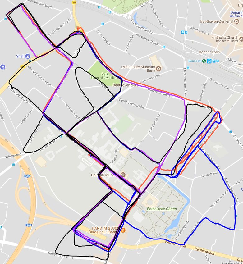
4                                                                 IEEE ROBOTICS AND AUTOMATION LETTERS. PREPRINT VERSION. ACCEPTED JANUARY, 2019

                                                                   reference         a reference image sequence. The synchronization of the ref-

                                            query
                                                                      map
            reference                                                                erence sequences then comes naturally from incorporating the
    query

                                                                                     information about street crossings. Further, we will describe a
    0                                  TP
                                                                                     way to arrange a set of images into sequences.
    1                                  FN, FP                                           As a first step, we extract the GPS coordinates of the streets
    2                                  FP                                            from OpenStreetMaps [18]. Obtaining the street coordinates
    3                                  FN                                            from OpenStreetMaps requires only parsing the provided xml
    4                                  TN                                            file. The OpenStreetMaps API provides for every street a set
                                                                                     of GPS coordinates in form of street segments. The size of the
                                                                                     line segment, e.g. the distance between the GPS coordinates,
                                                                                     depends on the shape and curvature of the street. If the street
Fig. 3: Left: Evaluating per image data associations between query
and reference sequences. Blue crosses denote the matches found
                                                                                     is long and straight, we should expect small amount of GPS
by our algorithm. Green squares denote the ground truth solutions.                   points with large distance between them and vice versa if the
TP-true positive, TN - true negative, FP - false positive, and FN                    street is curvy, we get a lot of small segments that describe the
- false negative. Right: E s (pink circles) relocalization edges; E m                physical shape of this street. Afterwards, for every segment we
- correspondence edges; M (j, t) (green arrow) corresponds to the                    compute the heading of this street with respect to the North,
images that represent the same place from different image sequences.
                                                                                     since this is one of the parameters from Google Street View
                                                                                     API. Heading defines basically which way the car is facing
At the same time, we allow for transitions between reference                         the street. Since the road segments can be quite long, we
sequences given the identified correspondences through the                           interpolate the points in between the segment endpoints to get
function M (). Thus, the set of edges E m interconnects the                          more locations to query a panorama image from. Having GPS
images along the different reference trajectories, i.e.:                             coordinates with associated headings for every street allows
                                                                                     us to directly query images into sequences.
                        E m = {(xijt , xi+1
                                        γ )}γ=M (j,t)−K,...,M (j,t)+K          (3)      Performing visual place recognition against Street View
                                                                                     imagery imposes several further challenges. In addition, to
   Finally, in case the vehicle looses track of its localization,
                                                                                     being collected in different point in time, with respect to query
either due to a failure or due to the fact that it had left
                                                                                     sequence as well as within the panoramas sequences itself, the
the previously mapped area, the last node of the current
                                                                                     frame rate of the panoramas is not constant. There are parts
best matching hypothesis xi∗ is connected to the set of the
                                                                                     of the street where the density of panorama images is higher,
candidates obtained from our hashing scheme:
                                                                                     which gives better place coverage in comparison to the places
                                E l = {(xi∗ , xi+1                                   where the density is lower. Furthermore, the viewpoint change
                                               c )}c∈C(qi+1 )                  (4)
                                                                                     can get severe, firstly because the camera on the Google car
   Each edge e ∈ E, independently of type, has a weight                              was mounted on the poll on the rooftop, whereas the camera
w(e) assigned to it. The weight is inverse proportional to the                       in our experiments is mounted inside of the car. Secondly, it
similarity score between the images. If an edge connects two                         is not guaranteed that the cars have taken the same lanes. This
nodes (xijt , xi+1                             i+1            i+1
               j 0 t0 ), the weight w(e) = 1/zj 0 t0 , where zj 0 t0                 becomes particularly challenging for carrying out recognition
is the cosine distance between query image feature i + 1                             tasks in the cities with wide streets (6 lanes), since the same
and reference image feature (j 0 , t0 ). In this paper, we use                       place may look substantially different from different sides of
NetVLAD features that were designed to be compared with                              the street.
Euclidean distance, so w(e) is given by the Euclidean distance
between two feature vectors now.                                                                  IV. E XPERIMENTAL E VALUATION
                                                                                        We designed the experimental evaluations to support the
C. Leveraging Google Street View For Multi-trajectory Visual                         claims made in this paper, which are the following ones:
Place Recognition                                                                    Our approach for sequence-based visual place recognition
                                                                                     in changing environments is able to efficiently relocalize
   As presented in previous section, our algorithm is able
                                                                                     against (i) multiple image sequences collected with similar
to recognize places within multiple image sequences. These
                                                                                     camera setup, (ii) imagery coming from different modalities,
reference sequences should be collected beforehand which
                                                                                     sequences collected on bike as well as in the car, (iii) imagery
may be a tedious work to do. Instead, we can also use already
                                                                                     from Google Street View, and (iv) we are able to localize an
publicly available sources, like Google Street View, which
                                                                                     imagery from random YouTube video within the Google Street
provides panorama images from all over the world. Using
                                                                                     View. Note, there are no constraints on shape, length or visual
Google Street View API, we query images from Street View
                                                                                     change of the trajectories.
given a GPS coordinate as well as a selected heading. To ex-
ploit this information within our place recognition framework,
we perform a sequence of transformations that turn a set of                          A. Evaluation Setup
unordered images into the map of image sequences.                                      To describe our evaluation setup, we first analyze the output
   We form image sequences by combining the Street View                              of the matching algorithm. Our place recognition system
Images along streets. Then each individual street turns to be                        reports for every query image if there is a matching image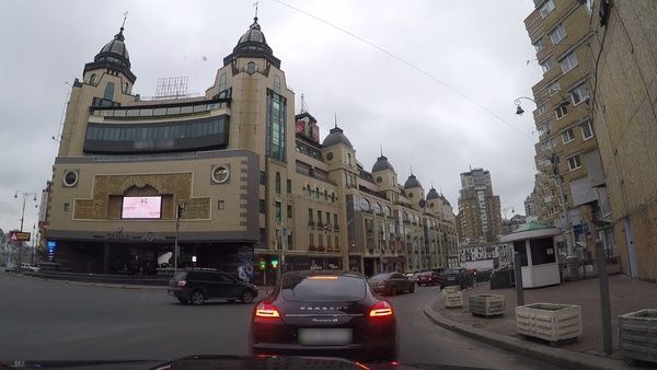
VYSOTSKA et al.: EFFECTIVE VISUAL PLACE RECOGNITION USING MULTI-SEQUENCE MAPS                                                                 5

                                                                         Fig. 5: Left: Accuracy plot for the dataset in Fig. 4. Right: accuracy
                                                                         for a larger query sequence against three reference trajectories,
                                                                         depicted in Fig. 1.

Fig. 4: Left: Query trajectory drawn in black and shifted artificially
for better visibility, others are reference trajectory. Right: Query
trajectory painted in the colors of the reference trajectories it was
matched to.

in the reference dataset as well as what exactly that image is.
We consider two images to match if their GPS coordinates lie
within the 30 meters range. There are 5 types of situations
that can happen while evaluating a match for a query image,
see Fig. 3. First case, true positive (TP) occurs when the
algorithm found a match that is in the set of ground truth
matches as for the query image 0 in Fig. 3. Second case, false
negative (FN) there is a match for a query image 3 in the
dataset, but the algorithm failed to detect it. Third case, false
positive (FP) when the algorithm has detected a match but
there should be no match for a query image, as for image                 Fig. 6: Top: Matching image pair from query (bike) left and reference
2. This typically happens when the query trajectory makes a              (car) right. Bottom: Accuracy curve. DBoW2 and SeqSLAM perform
detour from the reference ones. Fourth case, true negative (TN)          poorly on this dataset, since SeqSLAM was not designed to work
                                                                         with multiple sequences and DBoW2 works with descriptors that are
there is no match in the ground truth set and the algorithm has
                                                                         unable to deal with seasonal changes.
correctly not found it as in the image 4. The other possible
situation is that there exists at least one ground truth image
correspondence for a query image but the algorithm failed to             FABMAP we select for every query image a matching image
detect it and found a wrong match instead as for the image               if it has the highest probability. Whenever the probability
1. Then, by our definition this match is a false positive as             exceeds the predefined matching threshold, then the match is
well as false negative. To not penalize this situation twice,            considered valid, otherwise the query match does not have
we increment the set of FP and FN not by 1 as for the other              a matching image in the reference dataset. To obtain the
cases but by 0.5. Afterwards, we compute the accuracy for                accuracy curve, we vary the matching probability threshold
individual dataset as                                                    from 0 to 1. The same evaluation strategy holds for the DBow2
                              TP + TN                                    but there we threshold by the score and not by the probability.
                acc =                            .            (5)
                       TP + TN + FP + FN                                    Additionally, we compare our search strategy against the
   Since the performance of our search algorithm depends on              algorithm that compares every query image to every image
the non-matching parameter m, we vary this parameter to                  in the reference dataset – a property that an online approach
evaluate the behavior of the search. This allows to obtain the           cannot have. This algorithm operates with the same features
accuracy curve. For the last experiment, we do not provide the           as ours, but selects the match with the smallest cost from all
accuracy curve since we do not have GPS coordinates of the               the reference sequences, making it a fully informed search,
YouTube video footage.                                                   labeled as FI in the plots, also known as exhaustive search. A
   To provide comparative evaluations, we use an open-source             match for a query image is accepted if the matching cost is
version of FABMAP [9] algorithm as well as open-source                   smaller than a non-matching cost parameter m. The curve is
version of DBow2 [8]. To adjust it to our setup, we trained              generated by varying the non-match parameter.
the vocabulary for both approaches on several extra datasets                Furthermore, we have compared our approach to the state
that exhibit similar visual conditions, like viewpoint changes,          of the art approach in visual place recognition under dramatic
changes in environmental appearance, etc. We used the default            visual appearance changes, SeqSLAM [15]. Since SeqSLAM
provided parameters for both approaches. Since FABMAP and                is designed to match two sequences of images, we applied the
DBow2 do not explicitly work with reference data represented             same strategy as for FABMAP and DBow2 to convert our ref-
with multiple trajectories, throughout all our experiments we            erence map of multiple sequences into one reference sequence.
stacked reference trajectories into a single big trajectory. For         For clarification, the x-axis (Parameter) on all accuracy plots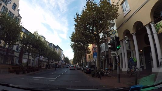
6 IEEE ROBOTICS AND AUTOMATION LETTERS. PREPRINT VERSION. ACCEPTED JANUARY, 2019
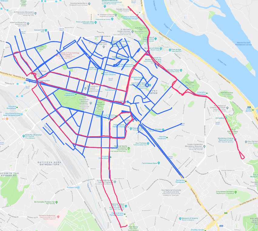
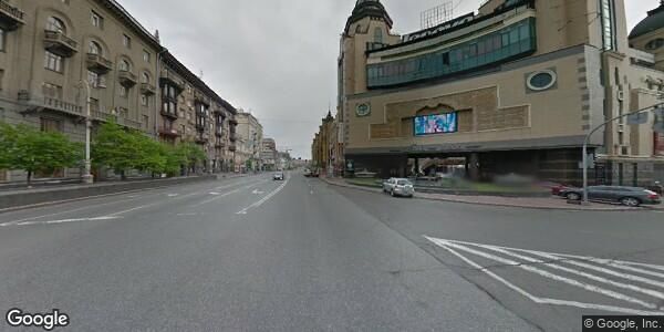
Fig. 7: An example matching image pair from the car perspec- Fig. 9: A matching image pair found by our approach from a YouTube
tive (left) and from Google Street View (right). video (left) and from Google Street View (right).
camera on the dashboard of a car and on a helmet of the
bicyclist. This setup imposes a particular viewpoint challenge,
see Fig. 6 (top) for an example of a matching pair between a
query (bike) image on the left and a reference (car) image on
the right, successfully found by our algorithm. Fig. 6 (bottom)
shows that our approach has a comparable performance to the
FI with around 80% accuracy and they both outperform FAB-
Fig. 8: Left: City streets for which panorama images were extracted MAP, DBoW2, and SeqSLAM for this dataset.
(blue), query trajectory driven by a car (pink). Right: Corresponding The third experiment is designed to show that the ideas of
accuracy plot. place recognition against multiple trajectories can be success-
fully applied to relocalize against Google Street View. As was
correspond to the non-matching cost m for our algorithm noted before, place recognition against street view is more
and FI search, to the probability threshold for FABMAP and challenging due to irregular frame rate of panorama images,
to weight threshold for DBoW2. The scale only shows how partially drastic viewpoint changes on top of environmental
many parameters are used. To evaluate our approach we have visual appearance changes. The query trajectory in this exper-
collected several types of datasets. We used goPro Hero 6 iment consists of 3,800 images whereas the total amount of
camera with additional GPS for ground truth evaluations. The extracted panorama images is 10,272. Fig. 7 shows a typical
camera was mounted on the front window of a car or on the matching example from query and Street View. As can be seen
helmet of bicyclist. Throughout our experiments the images from Fig. 8 (right) taking sequence information into account
were extracted at 1 fps. (our approach) outperforms the pure FI search and results
at best with 58% accuracy versus 48% for informed search.
Please note that DBoW2, FABMAP, and SeqSLAM were not
B. Experimental Results designed to operate on multiple reference image sequences,
In the first experiment, we show that our system is able to which results in the poor performance of those algorithms in
recognize previously visited places within multiple reference the challenging conditions tackled in this paper.
trajectories. The query trajectory consists of 636 images and The forth experiment is designed to show that our approach
was collected during the evening. There are three reference can recognize places from a random street drive footage taken
trajectories (around 3k images in total) of different shapes that from YouTube. The particular challenge of this experiment
were collected during the rainy morning, early and late evening lies in the fact that both query and reference sequences were
respectfully. Fig. 4 shows the GPS trajectories of the reference collected with different cameras as well as different unknown
sequences (pink, blue, cyan) as well as query (black) sequence. to us positioning setup. Fig. 9 shows a matching pair that was
Fig. 4 (right) shows the trajectory of a query sequence drawn successfully found by our approach. This experiment shows
with the color of reference trajectory it was localized against. that our algorithm is robust to recognize places using images
Black corresponds to the fact that no reference image was only from unknown camera setups. We do not provide the
found. As can be seen most of the time, the query sequence accuracy evaluations for this experiment due to the lack of
is localized successfully against reference trajectories (pink or exact positioning information from the YouTube video.
cyan) as well as almost no correct place associations made for
the cases, where query trajectory deviates from any reference C. Timings
trajectories, the part where black trajectory deviates from all In this experiment, we confirm that the proposed algorithm
reference trajectories. Quantitative evaluations are shown in allows for faster image matching than fully informed search.
Fig. 5 (left). As can be seen, our approach shows similar We performed the runtime measuring on all of the previously
accuracy to the fully informed matching (FI) and outperforms mentioned datasets by averaging the performance of individual
the FAB-MAP as well as DBow2 approaches. Fig. 5 (right) datasets within the 10 runs and selecting the non-matching
depicts accuracy results for another dataset depicted in Fig. 1 parameter that leads to the highest accuracy. Fig. 10 shows
with query trajectory of 2,022 images and shows similar average matching time for a query image with respect to
performance of our algorithm. the size of reference dataset, e.g. total number of images
The second experiment is designed to show that our search in reference sequences. Since FI algorithm matches a query
approach is able to perform reliable visual place recognition image to every image in the reference dataset, the time needed
for the cases when trajectories have been collected using for finding a match grows with increasing dataset size, whereas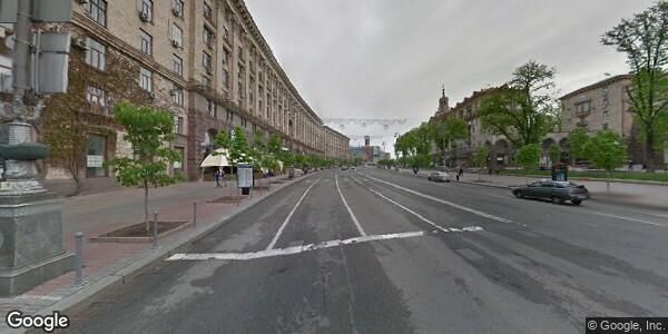
VYSOTSKA et al.: EFFECTIVE VISUAL PLACE RECOGNITION USING MULTI-SEQUENCE MAPS                                                                           7

                                                                                                   ACKNOWLEDGMENTS
                                                                             We gratefully acknowledge Oleg Vysotskyy for his support
                                                                          during data collection and Igor Bogoslavskyi for the fruitful
                                                                          discussions.

                                                                                                         R EFERENCES
                                                                           [1] P. Agarwal, W. Burgard, and L. Spinello. Metric Localization using
                                                                               Google Street View. In Proc. of the IEEE/RSJ Intl. Conf. on Intelligent
                                                                               Robots and Systems (IROS), Hamburg, Germany, 2015.
                                                                           [2] R. Arandjelovic, P. Gronat, A. Torii, T. Pajdla, and J. Sivic. Netvlad: Cnn
Fig. 10: Comparison of the running time for the proposed algo-                 architecture for weakly supervised place recognition. In Proceedings
rithm (our) and for the fully informed search (FI). Every point depicts        of the IEEE Conference on Computer Vision and Pattern Recognition,
                                                                               pages 5297–5307, 2016.
the average time to find a match for a query image for the reference       [3] R. Arroyo, P.F. Alcantarilla, L.M. Bergasa, and E. Romera. Fusion
datasets of various sizes.                                                     and Binarization of CNN Features for Robust Topological Localization
                                                                               across Seasons. In Proc. of the IEEE/RSJ Intl. Conf. on Intelligent
                                                                               Robots and Systems (IROS), 2016.
our approach experiences only slight increase in running time.             [4] H. Badino, D. Huber, and T. Kanade. Visual topometric localization. In
In general, the performance of our algorithm is independent                    2011 IEEE Intelligent Vehicles Symposium (IV), pages 794–799, 2011.
                                                                           [5] Z. Chen, O. Lam, A. Jacobson, and M.Milford. Convolutional neural
from the size of the reference dataset. To show this, we                       network-based place recognition. In Proc. of the Australasian Conf. on
augmented the dataset that had 10,000 images with 4,000                        Robotics and Automation (ACRA), 2014.
additional ones and leaving the query trajectory the same. As              [6] W. Churchill and P. Newman. Experience-Based Navigation for Long-
                                                                               Term Localisation. Intl. Journal of Robotics Research (IJRR), 2013.
can be seen the runtime of the FI algorithm for the dataset is             [7] M. Cummins and P. Newman. Highly scalable appearance-only SLAM -
increased whereas for our algorithm stayed almost the same.                    FAB-MAP 2.0. In Proc. of Robotics: Science and Systems (RSS), 2009.
The relocalization step in our approach, however, may lead to              [8] D. Galvez-Lopez and J. D. Tardos. Bags of binary words for fast
                                                                               place recognition in image sequences. IEEE Trans. on Robotics (TRO),
an increase in runtime. Whenever the robot is lost, querying                   28(5):1188–1197, Oct 2012.
the candidate locations in performed via a variant of hashing,             [9] A. Glover, W. Maddern, M. Warren, S. Reid, M. Milford, and G. Wyeth.
whose performance is directly influenced by the size of the                    Openfabmap: An open source toolbox for appearance-based loop closure
                                                                               detection. In Proc. of the IEEE Intl. Conf. on Robotics & Automation
dataset. Also matching capability of the features influence the                (ICRA), pages 4730–4735, 2012.
search speed. The more distinctive the matching scores are,               [10] C. Linegar, W. Churchill, and P. Newman. Work Smart, Not Hard:
e.g., the bigger the score difference between the matching pairs               Recalling Relevant Experiences for Vast-Scale but Time-Constrained
                                                                               Localisation. In Proc. of the IEEE Intl. Conf. on Robotics & Automation
and non-matching pairs is, the faster the search will reject                   (ICRA), 2015.
unpromising candidates and thus runtime will decrease.                    [11] Q. Lv, W. Josephson, Z. Wang, M. Charikar, and K. Li. Multi-probe
                                                                               lsh: efficient indexing for high-dimensional similarity search. In VLDB,
                                                                               pages 950–961, 2007.
D. Limitations                                                            [12] F. Maffra, Z. Chen, and M. Chli. Viewpoint-tolerant place recognition
   Since the matching performance of our algorithm depends                     combining 2d and 3d information for uav navigation. In Proc. of the
                                                                               IEEE Intl. Conf. on Robotics & Automation (ICRA). IEEE, 2018.
on the non-matching parameter m, selecting it correctly may               [13] A.L. Majdik, Y. Albers-Schoenberg, and D. Scaramuzza. Mav urban
be not an obvious thing to do. Also we observe a performance                   localization from google street view data. In Proc. of the IEEE/RSJ
degradation whenever the visual appearance changes within                      Intl. Conf. on Intelligent Robots and Systems (IROS), pages 3979–3986,
                                                                               2013.
the query sequence. For example, if the sequence starts at                [14] M. Milford. Vision-based place recognition: how low can you go?
the evening and matching continues for a long time, so that                    Intl. Journal of Robotics Research (IJRR), 32(7):766–789, 2013.
it gets dark outside, the same non-matching parameter that                [15] M. Milford and G.F. Wyeth. SeqSLAM: Visual route-based navigation
                                                                               for sunny summer days and stormy winter nights. In Proc. of the IEEE
reasonably described the non-matchiness of the sequence is                     Intl. Conf. on Robotics & Automation (ICRA), 2012.
no longer valid.                                                          [16] T. Naseer, L. Spinello, W. Burgard, and C. Stachniss. Robust Visual
                                                                               Robot Localization Across Seasons using Network Flows. In Proc. of
                       V. C ONCLUSION                                          the Conf. on Advancements of Artificial Intelligence (AAAI), 2014.
                                                                          [17] P. Neubert, N. Sunderhauf, and P. Protzel. Appearance Change Pre-
   We presented a novel approach for quickly finding cor-                      diction for Long-Term Navigation Across Seasons. In Proc. of the
respondences between a currently observed image stream                         Europ. Conf. on Mobile Robotics (ECMR), 2013.
                                                                          [18] OpenStreetMaps. https://www.openstreetmap.org.
and a map of several previously recorded image sequences                  [19] P. Sermanet, D. Eigen, Z. Zhang, M. Mathieu, R. Fergus, and Y. LeCun.
given substantial appearance changes. Matching is performed                    Overfeat: Integrated recognition, localization and detection using con-
through an informed search in a data association graph that is                 volutional networks. In Intl. Conf. on Learning Representations (ICLR),
                                                                               2014.
built incrementally. By deploying hashing technique, we are               [20] K. Simonyan and A. Zisserman. Very deep convolutional networks for
able to relocalize the robot if it is lost as well as between                  large-scale image recognition. arXiv preprint, abs/1409.1556, 2014.
multiple image sequences. Additionally, we showed how to                  [21] E. Stumm, C. Mei, S. Lacroix, and M. Chli. Location Graphs for Visual
                                                                               Place Recognition. In Proc. of the IEEE Intl. Conf. on Robotics &
leverage publicly available Google Street View imagery within                  Automation (ICRA), 2015.
our framework. Our evaluations show that we can perform                   [22] O. Vysotska and C. Stachniss. Lazy Data Association for Image
place recognition faster than offline, fully informed search with              Sequences Matching under Substantial Appearance Changes. IEEE
                                                                               Robotics and Automation Letters (RA-L), 2016.
the comparable or better matching performance in presence                 [23] O. Vysotska and C. Stachniss. Relocalization under substantial appear-
of drastic visual appearance changes as well as viewpoint                      ance changes using hashing. In Proc. of the IROS Workshop on Planning,
changes.                                                                       Perception and Navigation for Intelligent Vehicles, 2017.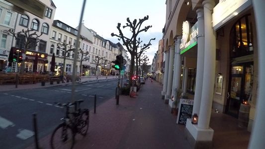

You can also read