Environmental Setting and Impact Analysis Approach - San Joaquin ...
←
→
Page content transcription
If your browser does not render page correctly, please read the page content below
Environmental Setting and Impact Analysis Approach
3 Environmental Setting and Impact
Analysis Approach
This section provides a general overview of the environmental setting for the 2018 RTP/SCS,
including a regional setting, sub-regional setting, and a description of the regional transportation
system. This section also outlines the EIR baseline and approach to both direct and cumulative
impact analyses. More detailed descriptions of the environmental setting for each environmental
issue area can be found in Section 4.0, Environmental Impact Analysis.
3.1 Regional Setting
Located at the center of California’s vast agricultural operations, San Joaquin County is located in
San Joaquin Valley. The County encompasses over 900,000 acres (about 1,425 square miles) and is
bordered by Sacramento County to the north, Stanislaus County to the south, Amador and Calaveras
Counties to the east, and Contra Costa and Alameda Counties to the west. The county seat for San
Joaquin County is the city of Stockton. San Joaquin County includes relatively level, agriculturally
productive lands. Major landforms in the County include the foothills of the Diablo Range in the
southwest, the foothills of the Sierra Nevada in the east, and the Delta in the northwest. State Route
99 (SR 99) and Interstate 5 (I-5), two of the State’s major north-south freeways, pass through San
Joaquin County. Interstate 205 (I-205) and Interstate 580 (I-580) provide direct connections to the
San Francisco Bay Area to the west. Three transcontinental railroads (including Amtrak Service), the
Stockton Metropolitan Airport, and the Port of Stockton connect the County to the State, nation,
and world.
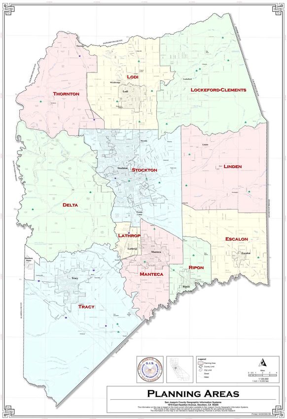
The County General Plan divides San Joaquin County into 12 Planning Areas as follows: the Delta,
Escalon, Lathrop, Linden, Lockeford, Lodi, Manteca, Mountain House, Ripon, Stockton, Thornton,
and Tracy (see Figure 4). The General Plan Planning Areas include all lands within the County line,
not including lands in the seven incorporated cities (i.e., Escalon, Lathrop, Lodi, Manteca, Ripon,
Stockton, and Tracy) and any additional areas in which adopted County policies may relate.
3.2 Regional Growth Setting
The County covers approximately 1,440 square miles and is predominantly flat land with some
gently rolling hills. The County is bordered to the southwest by the Diablo Range and to the east by
the Sierra Nevada foothills. The County contains a combination of metropolitan and rural areas with
a long history of agricultural activities. San Joaquin County is considered one of the fastest growing
regions in the Central Valley, with the population expected to reach over a million people by the
year 2042.
While much of this trend continues to be the result of “spillover” from the Bay Area, the County’s
geographical advantages and quality of life also contribute to the growth. This growth has led to
increased urbanization and the persistent challenge to meet state and federal air quality
requirements.
Draft Programmatic Environmental Impact Report 61San Joaquin Council of Governments 2018 Regional Transportation Plan/ Sustainable Communities Strategy Figure 4 SCS Land Use San Joaquin County 62
Environmental Setting and Impact Analysis Approach

Economically, San Joaquin County continues to grow in many segments of its economy. Downtown
revitalization efforts in Stockton, Big League Dreams in Manteca, and the Lodi area’s success
producing world-class wines are shaping San Joaquin County into a destination for tourism and
entertainment. The region also continues to be an attractive location for new warehousing and
distribution centers that serve Northern California, the Bay Area, and the west coast. A centralized
and diverse network of highway, rail, air, and seaport facilities support the continued development
of San Joaquin County into a major goods movement region.
As San Joaquin County is transformed, these growth factors have profound effects on the ability to
finance, deliver, and maintain the transportation infrastructure. The 2018 RTP/SCS aims to build on
the 2014 RTP/SCS to create both an efficient and effective multimodal transportation system for San
Joaquin County that balances the needs for maintenance and preservation with expansion and
enhancements. A conscious effort is made to design a system that both promotes mobility as well as
preserves the environment. This effort is guided by a set of overarching goals.
Due primarily to the availability of housing at lower costs than surrounding communities to the
north and to the west of San Joaquin County, the County is a place where many residents travel long
distances for employment outside the County. Specifically, State Routes 4 and 12 link the east and
west sides of the County. Each operates as a freeway segment for a brief but important segment
between State Route 99 and I-5. Both routes also connect with Bay Area counties across the San
Joaquin Delta and carry significant commuter and interregional traffic.

3.3      Regional Transportation System
3.3.1 San Joaquin County
The San Joaquin County transportation system is designed to meet the multiple needs of residents
and businesses. The County’s central position within the state provides key routes and linkages for
the movement of goods throughout California and to the rest of the United States. The County has
one of the few deep-water ports within the State at the Port of Stockton, an airport that serves
international markets, key highway corridors, and the hub for a number of major railroads. Given
the County’s location, San Joaquin County serves as a major transportation center for warehousing
and distribution activities, as well as a source of more affordable housing for employees working in
the Bay Area.
Several major vehicle routes traverse the County and provide important links for employees and
goods to other parts of California, such as the Bay Area and Sacramento. These major routes include
Interstates I-5, 205, and 580, as well as State Routes 99, 120, 12 and 4. The I-205/I-580 corridor
serves as a major gateway between the Bay Area/Silicon Valley and the County.
The County has six airports open to the public that offer a variety of aviation services, to various
domestic and international locations. Stockton Metropolitan Airport is owned and operated by the
County, and offers general aviation services along with commercial passenger service to places such
as Las Vegas, Phoenix, and San Diego. The second largest airport is the Tracy Municipal Airport,
which is owned and operated by the City of Tracy.
There are a number of rail lines that traverse the County and provide transportation services for
both passengers and freight. A partnership between the Union Pacific and the Burlington Northern
and Santa Fe (BNSF) Corporation operates an intermodal shipping yard providing a key connection
for truck-rail freight movement. Amtrak provides passenger service to the County, while Altamont

Draft Programmatic Environmental Impact Report                                                     63
San Joaquin Council of Governments
2018 Regional Transportation Plan/ Sustainable Communities Strategy
Commuter Express (ACE) provides direct commuter rail service to Silicon Valley (with stops in
Stockton, Lathrop, Manteca, and Tracy).
Regional public transit is provided by San Joaquin Regional Transit District (SJRTD) bus service. The
SJRTD offers fixed-route buses, intercity buses, interregional buses, and dial-a-ride services. Local
bus services are provided by transit operators in most of the local jurisdictions throughout the
County. A variety of Class I-III bicycle routes in many areas provide additional transit alternatives.
3.4 EIR Baseline, Approach for Direct and Cumulative
Analyses
3.4.1 EIR Baseline
Section 15125 of the CEQA Guidelines states that an EIR “must include a description of the physical
environmental conditions in the vicinity of the project, as they exist at the time the notice of
preparation [NOP] is published.” Section 15125 states that this approach “normally constitute[s] the
baseline physical conditions by which a lead agency determines whether an impact is significant.” In
certain instances, the lead agency has the discretion to use a baseline other than existing conditions
at the time of the release of the NOP based on the information available at the time the analysis is
being performed.
This EIR evaluates potential impacts against existing conditions at the time of the release of the NOP
(March 2017), where information is available, for issue areas that would not be substantially
influenced by future regional growth that would occur with or without implementation of the 2018
RTP/SCS. It was determined that for these issues a comparison to current, existing baseline
conditions would provide the most relevant information for the public, responsible agencies, and
SJCOG decision-makers. These issue areas include:
Aesthetics Geology and Soils
Agriculture and Forestry Hazards and Hazardous Materials
Biological Resources Hydrology and Water Quality
Cultural Resources Land Use
Energy Tribal Cultural Resources
Environmental Justice
For impacts related to air quality, noise, greenhouse gas, and traffic, this EIR evaluates potential
impacts against both (1) a forecast future baseline condition and (2) current, existing baseline
conditions, controlling for impacts caused by population growth and other factors that would occur
whether or not the 2018 RTP/SCS is adopted. The 2018 RTP/SCS is a long-term plan that proposes
transportation projects and land use patterns to the year 2042. It is important to emphasize that
population growth, urbanization, and volume of average daily traffic generated in the SJCOG region
will increase by 2042, with or without implementation of the 2018 RTP/SCS, as a result of a range of
demographic and economic factors independent of policy and land use decisions by SJCOG and its
member agencies. Therefore, this SEIR evaluates potential impacts against both a future baseline
and a current baseline standard .
64Environmental Setting and Impact Analysis Approach An analysis that attributed physical environmental impacts solely to the 2018 RTP/SCS that are in fact due to future regional growth that would occur in the absence of the 2018 RTP/SCS would overstate the impacts caused by the 2018 RTP/SCS. For this reason, certain environmental issues analyzed in the EIR compare future conditions including the 2018 RTP/SCS with the expected future conditions without the 2018 RTP/SCS (the “future baseline”) as well as to the current baseline, controlling for future regional growth that would occur independently of the 2018 RTP/SCS. These comparisons isolate environmental effects potentially resulting from the 2018 RTP/SCS from those caused by future growth that would occur regardless of the 2018 RTP/SCS, as compared to existing baseline conditions in March 2017. Identification of potential impacts and mitigation measures for these environmental issue areas are therefore based on the increment of physical change due to 2018 RTP/SCS, rather than the future regional growth that would occur regardless of whether or not the plan is adopted and implemented. The environmental issue areas for which this approach is used include the following: Air Quality Greenhouse Gases Emissions/Climate Change Noise Transportation and Circulation 3.4.1.1 Interim Timeframes 2042 is the horizon year of the proposed 2018 RTP/SCS. While the RTP/SCS would be implemented gradually over the planning period, this EIR does not analyze interim time frames because the four/five-year update cycle of the RTP/SCS already requires short-term adjustments to the Plan. The one exception to this approach is in Section 4.9, Greenhouse Gas Emissions/Climate Change, which examines impacts for the year 2020 and 2035, as well as a comparative baseline from 2015, to satisfy statutory requirements and state goals related to GHG emissions (Health & Safety Code, § 38551(b)). A summary of the scenarios considered in the GHG analysis is provided in Section 4.8.2 in Section 4.9, Greenhouse Gas Emissions/Climate Change. 3.4.2 Approach for Direct Analysis The programmatic nature of the 2018 RTP/SCS necessitates a general approach to the evaluation of existing conditions and impacts associated with the proposed project. As a programmatic document, this EIR presents a region-wide assessment of the impacts of the 2018 RTP/SCS. These impacts are examined for both transportation network improvements and the regional growth and land use changes forecasted. Because the EIR is a long-term document intended to guide actions for roughly 25 years into the future, program-level and qualitative evaluation is involved. Quantitative analyses are provided where applicable with available information. During future stages in planning and implementation of specific elements of the 2018 RTP/SCS, including land development resulting from regional growth and transportation improvements identified in the 2018 RTP/SCS, project- specific CEQA documents will be prepared by the appropriate project implementation agency. For analytical purposes, the baseline year examined throughout this EIR is 2017, when the NOP was published, except where specifically noted to correspond with the RTP traffic modeling data using 2015 as a baseline, and as further described in Section 3.4.1.1 above. Draft Programmatic Environmental Impact Report 65
San Joaquin Council of Governments
2018 Regional Transportation Plan/ Sustainable Communities Strategy

3.4.3      Approach for Cumulative Analysis
CEQA defines cumulative impacts as “two or more individual effects which, when considered
together, are considerable, or which can compound or increase other environmental impacts.”
Section 15130 of the CEQA Guidelines requires that an EIR evaluate potential environmental
impacts that are individually limited but cumulatively considerable. These impacts can result from
the proposed project alone, or together with other projects. The CEQA Guidelines state: “The
cumulative impact from several projects is the change in the environment which results from the
incremental impact of the project when added to other closely related past, present, and reasonably
foreseeable probable future projects” (CEQA Guidelines, Section 15355). A cumulative impact of
concern under CEQA occurs when the net result of combined individual impacts compounds or
increases other overall environmental impacts (CEQA Guidelines, Section 15355). In other words,
cumulative impacts can result from individually minor but collectively significant projects taking
place over a period of time. CEQA does not require an analysis of incremental effects that are not
cumulatively considerable nor is there a requirement to discuss impacts which do not result in part
from the project evaluated in the EIR.

3.4.3.1     Cumulative Impact Methodology
The 2018 RTP/SCS is a cumulative plan by design. The Plan area is comprised of under a million acres
and seven cities plus census designated places. It integrates transportation investments with land
use strategies for an entire region of the state that shares, or is connected by, common economic,
social, and environmental characteristics. As such, the environmental analysis of the 2018 RTP/SCS
presented throughout this Draft EIR is a cumulative analysis compliant with the requirements of
CEQA and the CEQA Guidelines. Furthermore, this Draft EIR contains detailed analysis of regional
(cumulative) impacts, which are differentiated from localized impacts that may occur at the county
level. Nevertheless, the following discussion examines impacts associated with implementation of
the 2018 RTP/SCS, plus implementation of projected development for jurisdictions adjoining the
SJCOG region, to assess the potential for cumulative impacts from growth extending beyond the
region.
When evaluating cumulative impacts, CEQA allows the use of either a list of past, present, and
probable future projects, including projects outside the control of the lead agency, or a summary of
projections in an adopted planning document, or a thoughtful combination of the two approaches.
The cumulative analysis presented in this document uses a projections-based approach. Land use
and growth projections for the region, which are the subject of analysis throughout this Draft EIR,
are combined with the growth projections for the adjoining counties. Analysis of the cumulative
impacts of the 2018 RTP/SCS for each environmental issue area is presented at the ends of Sections
4.1 through 4.15.

66
You can also read