EXHIBIT "A" - COMBINED TRAIL PROJECTS 2021-2022
←
→
Page content transcription
If your browser does not render page correctly, please read the page content below
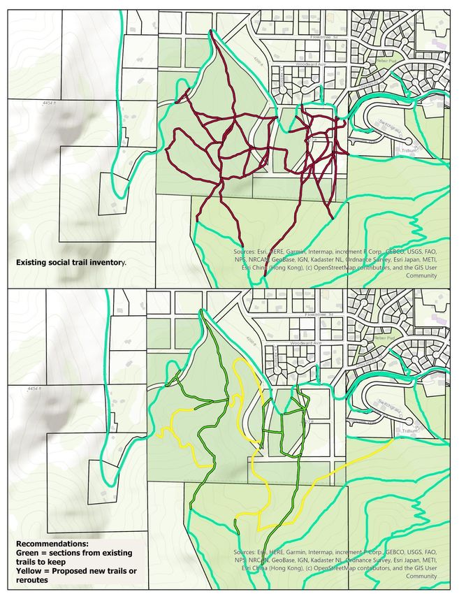
EXHIBIT “A” – COMBINED TRAIL PROJECTS 2021-2022

                                                          City of Helena Parks, Recreation, and Open Lands Departments
                                                                                      316 North Park Avenue, Room 405
                                                                                                 Helena, Montana 59601
                                                                                                   Phone: 406.447.8463
                                                                                  https://www.helenamt.gov/parks.html

City of Helena Open Lands Division Proposed Major Projects – City Recommendations Calendar Year 2022

Projects are evaluated based on alignment with the goals identified in Chapter 7, public feedback received to
date, Helena Open Lands (HOL) needs, available resources and guidance from HOLMAC.

Upper DeFord trail (North of the Old Shooting Range parking lot) – Brad Langsather, Presenter
Current Situation
There is an existing, unmanaged bike skills area located between the DeFord trail and Davis Street that has
numerous, unsigned entry points and no outflow trail. Additionally, bike traffic descending down the DeFord trail,
from its southernmost intersection with Davis Street to its northern intersection with Davis Street, adds to trail
congestion and creates safety concerns for some trail users.

Recommendation
The City recommends implementation of the following items:
   1. Improve DeFord trail from the Old Shooting Range parking lot to the Archery Range parking lot (suggested:
        widen and improve surface – decomposed granite or other such option; pedestrian lights/signage as it
        crosses Davis Gulch Road).
   2. Designate DeFord trail as defined in 1 as a Shared-Use-path although downhill bike traffic will be
        discouraged.
   3. Create a directional bike trail from where the DeFord trail begins after crossing Davis Gulch Rd to the
        Archery Range parking lot and develop signage to encourage downhill bike traffic to use the directional
        trail.
   4. Improve DeFord trail from where the trail begins after crossing Davis Gulch Rd to Eagle Scout Trailhead to
        include, where appropriate, signage, fencing, and high mark remediation. Signage recommendations
        include speed-related signage, and community norm-related signage, such as “take care of everyone”.
   5. Improve directional bike skills course from north of the Archery Range parking lot to where the DeFord
        Trail joins Davis Gulch Road to include a sessioning trail to encourage bike traffic to stay on the skills
        course.
   6. Consider the creation of ADA parking in the Archery Range parking lot.
   7. Explore the possibility of completing a feasibility study to explore options for increased accessibility from
        the Archery Range parking lot to Eagle Scout Trailhead.

Upper DeFord trail (South of the Old Shooting Range parking lot) – Brad Langsather, Presenter
Current Situation
The topography in the Dry Gulch bottom south of the Old Shooting lends that portion of the DeFord trail residing
on this landscape to improvement/modification with regards to slope width, slope, and surface thereby making
it more accessible. Additionally, there is currently a lack of adequate signage to discourage pedestrians and/or
bikes form traveling uphill within the Upper Davis Bike Skills Course. Finally, in the event that the Upper DeFord
Trail becomes an accessible trail, there is currently no opportunity for the disabled community to access a charging
station to power their electric assist devices.

               Helena Open Lands Trail Projects 2021 / September 15, 2021 Listening Session / Page 1 of 15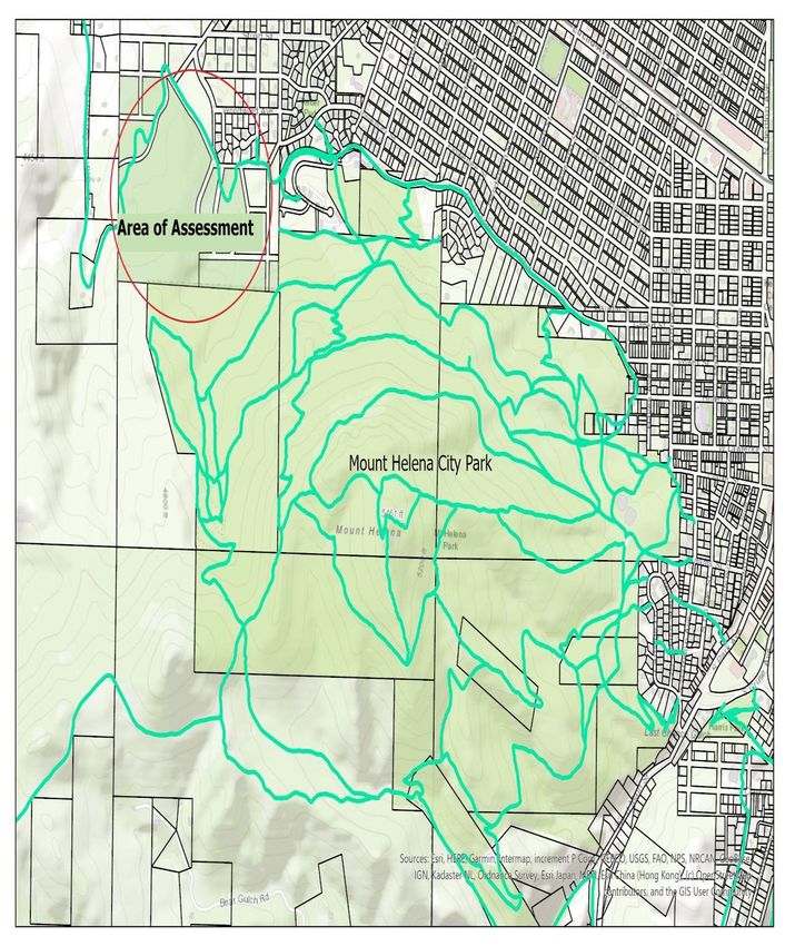
EXHIBIT “A” – COMBINED TRAIL PROJECTS 2021-2022
Recommendation
The City recommends we implement the following items:
1. Improve DeFord trail (suggested: widen; improved surface-decomposed granite or other such option,
raised trail where needed to prevent erosion).
2. Improve signage at the entrance and exit of the DeFord and Bike Skills Course trails.
3. Designate the DeFord trail as a Shared-Use path although downhill bike traffic will be discouraged.
4. Explore the feasibility of installing a charging station for wheelchairs at the Old Shooting Range parking
lot.
Estimated Budget
$37,400.00 (Trail Construction, Fencing and Decomposed Granite/road mix)
See Upper DeFord Improvement Project and Lower DeFord Improvement Project
CITY RECOMMENDATION(S): Based on alignment with the goals identified in Chapter 7 (community access and
use, future needs and growth), public feedback received to date, Helena Open Lands (HOL) needs, and available
resources, City staff recommends that this project move forward as proposed.
Mount Helena ADA Trail Construction Project – Brad Langsather, Presenter
Current Situation
The current Mount Helena ADA trail terminates at its intersection point with the Ambrose Trail thereby preventing
a portion of the disabled community from exploring the western reaches of Mount Helena City Park.
Recommendation
The City recommends implementation of the following items:
1. Widen Approximately 6,780 feet of the existing Ambrose trail & surface with decomposed granite.
2. Construct approximately 4,610 feet of new trail to an eventual intersection with the West LeGrande
Cannon Boulevard Trail & surface with decomposed granite.
3. Construct a pedestrian bridge capable of free spanning approximately 30 feet across a dry draw.
Estimated Budget
$95,000.00 (Decomposed Granite & Lumber/Hardware, Staff Wages)
CITY RECOMMENDATION(S): Based on comments received on this project, and available resources, this project
will be removed from consideration in the 2021 City of Helena Open Lands Major Projects evaluation process.
Whyte Acquisition Trail Improvement Project– Brad Langsather, Presenter
Current Situation
The Whyte property was acquired by PPLT and subsequently donated to the city of Helena in 2019. The property
comprises 90 acres primarily located to the south of the LeGrande Cannon trail west of the intersection between
LeGrande Cannon Boulevard and Silverette Street (See Figure 1). The terrain generally gains elevation as it heads
south towards the Mount Helena trail system and comprises grasslands as well as areas of Ponderosa Pine. There
are a number of gullies and drainages within the area. Existing trails are primarily historic jeep, motorcycle, and
game trails and a number of them connect to trails within the Helena Open Lands system. There are no
intentionally designed trails within the area and many trails do cross private property boundaries. A number of
trails are located on unsustainable grades and are candidates for closure or rerouting. It is challenging to come to
an exact figure but PPLT estimates that there are approximately 4 miles of existing trails on the 90 acre property.
Helena Open Lands Trail Projects 2021 / September 15, 2021 Listening Session / Page 2 of 15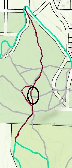
EXHIBIT “A” – COMBINED TRAIL PROJECTS 2021-2022
The LeGrande Cannon trail has an informal parking area located on either side of the trail that is managed by the
City of Helena. Much of the LeGrande Cannon trail itself, as well as the western parking area, are located on Lewis
and Clark County ownership.

There are two main north/south trails that anchor the trails on the property: Road to Mars to the east and Seven
Sisters to the west. Between these trails lies the bulk of the remaining intersecting trails and access points. Notably
there are existing trails west of Seven Sisters that connect to the western parking area and trails to the east of
Road to Mars that exist almost entirely on private land. For the purpose of this assessment PPLT will reference
three distinct areas: Road to Mars, Seven Sisters, and “the Meadow”. The Meadow is a centrally located area of
relatively gentle topography to the east of Seven Sisters that comprises a number of existing trails.

                Helena Open Lands Trail Projects 2021 / September 15, 2021 Listening Session / Page 3 of 15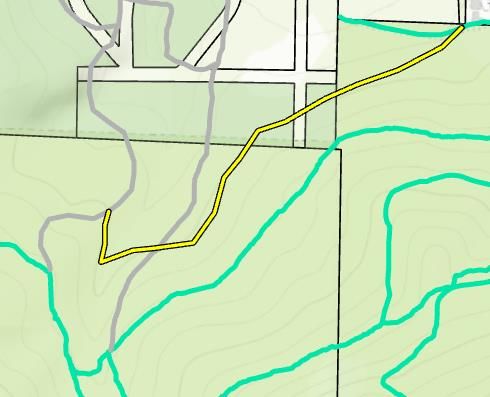
EXHIBIT “A” – COMBINED TRAIL PROJECTS 2021-2022
Recommendations

Reference Maps:

             Helena Open Lands Trail Projects 2021 / September 15, 2021 Listening Session / Page 4 of 15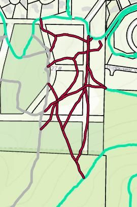
EXHIBIT “A” – COMBINED TRAIL PROJECTS 2021-2022
Recommended Closures, Designated Unmaintained Non-system Trails, and Reroutes:

Introduction:
Many trails on the Whyte property exist on unsustainable grades or on private property and as such should be
closed or rerouted. This assessment includes three categories: recommended closure, designate unmaintained
non-system trail, or reroute. A number of the trails identified within this assessment recommended for closure
may be appropriate for use as access roads for fire suppression or weed and forestry management. City staff will
review this assessment and determine which trails may be kept for access purposes. For the purposes of this
assessment trails recommended as closure mean that these routes will not be included on any future maps and
full obliteration of the existing trail is recommended. Trails that meet the “designate unmaintained non-system”
trail are either trails where full obliteration would not be possible or are candidates for use as access routes, these
would also not be shown on maps. It is challenging to get trail users to respect trail closures, this category is also
for trails that PPLT staff believe changing existing behavior patterns will be exceedingly difficult. Any trail with this
designation will be signed as such and will not be a part of PPLT’s annual trail maintenance. Reroutes are proposed
to improve existing trails to fix an existing issue. These issues include unsustainable existing routes and private
property encroachment. Note that all reroutes and proposed new routes shown on the maps are approximations
and these routes would need to be formally laid out, flagged, and, ultimately, approved by city staff.

Road to Mars Area:

                                                               All trails east of Road to Mars located on private
                                                               property were not assessed and should either be closed
                                                               formally or signed and fenced appropriately to notify
                                                               trail users of private property trespass.

                Helena Open Lands Trail Projects 2021 / September 15, 2021 Listening Session / Page 5 of 15
EXHIBIT “A” – COMBINED TRAIL PROJECTS 2021-2022

                                         Reroute Road to Mars in two locations to relocate trail off of private
                                         property.

                                               Reroute small section of trail west of Road to Mars to improve
                                               trail sustainability. Reroute trail connecting to the Meadow.

The Meadow Area:

                                                  Close and obliterate trails exiting the Meadow that go
                                                  directly up the fall line.

            Helena Open Lands Trail Projects 2021 / September 15, 2021 Listening Session / Page 6 of 15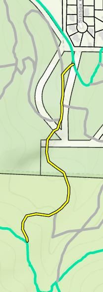
EXHIBIT “A” – COMBINED TRAIL PROJECTS 2021-2022

                                                       Designate the southern trail as an unmaintained non-
                                                       system trail due to fall-line nature and suitability as an
                                                       access road.

Seven Sisters Area:

                                                       Close and obliterate the unsustainable Seven Sisters
                                                       “alternate”.

                                                     Designate the “Old Chevy connector: as an unmaintained
                                                     non-system trail due to trail unsustainability and suitability
                                                     as an access road.

              Helena Open Lands Trail Projects 2021 / September 15, 2021 Listening Session / Page 7 of 15
EXHIBIT “A” – COMBINED TRAIL PROJECTS 2021-2022

                                    Note that this assessment preserves the Seven Sisters/Andy’s
                                    Trail connection as shown on the map. If the city elects to
                                    assess the adjacent Graham property for trail potential this
                                    trail would be a candidate for a reroute utilizing the land to
                                    the west and south.

                                     Close and obliterate Seven Sisters connector to northwest.

                                    Close and obliterate the two trails connecting to the western
                                    parking area.

Helena Open Lands Trail Projects 2021 / September 15, 2021 Listening Session / Page 8 of 15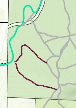
EXHIBIT “A” – COMBINED TRAIL PROJECTS 2021-2022
Trail obliteration considerations:
Given the high difficulty of getting trail users to respect trail closures in the South Hills PPLT recommends that,
where possible, obliterations are accomplished through mechanical means and signed appropriately. While
traditionally trail closures have occurred in the springtime to take advantage of favorable conditions it may be
time to consider fall closures, trying to time obliteration before snow falls with the hope that usage may be less
in the wintertime and thus lessen the possibility of users reopening the trail.

New Proposed Trails:

Introduction:
As the Whyte property comprises trails that were historically created by the use of jeeps and motorcycles or by
local wildlife, there is an opportunity to create new intentional trails and connections that meet community
recreational needs. This assessment looked at ways the landscape may add value to the existing open lands trail
system and improve the existing trail footprint. Factors that influenced the inclusion of proposed trails include
loss of trail access due to private property location, opportunities for logical connector trails and the fact that the
LeGrande Cannon trail is one of the more accessible locations and is heavily used by families, children, and
individuals with mobility issues. Note that all reroutes and proposed new routes shown on the maps are
approximations and these routes would need to be formally laid out, flagged, and, ultimately, approved by city
staff.

Northwest Passage reroute and new trail construction:

                                                              Northwest Passage has long since terminated at
                                                              private property and as such should either be formally
                                                              closed adjacent to private land or rerouted to serve a
                                                              more logical purpose. The proposed route leaves from
                                                              the trail’s connection to Reber Road and generally
                                                              follows the contour crossing Road to Mars and
                                                              ultimately connects with the Old Chevy area. If
                                                              Ambrose were to become the preferred route for an
                                                              ADA trail this development of Northwest Passage
                                                              would maintain a single track contour trail on the
                                                              lower north side of Mount Helena.

                Helena Open Lands Trail Projects 2021 / September 15, 2021 Listening Session / Page 9 of 15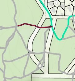
EXHIBIT “A” – COMBINED TRAIL PROJECTS 2021-2022
Old Chevy new trail:

                                                          This proposed trail would take advantage of some
                                                          favorable terrain to create a new access off of Mount
                                                          Helena down to LeGrande Cannon. This trail would be
                                                          the 3rd north/south trail in the area and provide
                                                          numerous options for users to create different trail
                                                          loops in the area. The terrain in this area lends itself to
                                                          more interesting and varied trail building and would be
                                                          a more interesting alternative to the much more direct
                                                          routes of Road to Mars and Seven Sisters. Would also
                                                          be able to connect directly to the Meadow and any new
                                                          trails located here.

The Meadow Loop(s)

                                                        The Meadow offers up a unique opportunity to create a
                                                        novice, entry level trail experience that much of the South
                                                        Hills system lacks. Given the accessible nature of
                                                        LeGrande Cannon, it is already a natural place to provide
                                                        some “easy” trails for recreationists. This area could
                                                        include one main loop or a “stacked loop” system that
                                                        provides the ability for people to choose trail loops of
                                                        varying length. Included in these proposed trails are
                                                        access points connecting this novice zone to the Seven
                                                        Sisters trail.

              Helena Open Lands Trail Projects 2021 / September 15, 2021 Listening Session / Page 10 of 15
EXHIBIT “A” – COMBINED TRAIL PROJECTS 2021-2022
Westside parking trail:
The proposed new trail would replace the
unsustainable existing trails that currently exist
from the parking area. The trail would climb up
the steep ridge using a series of turns and then
split with one trail splitting to Seven Sisters north
and the other to Seven Sisters south. This trail
would preserve access to the parking area and
improve trail sustainability.
Signage and Trail Names:
Introduction:
Formalizing the existing routes and the addition of any new trails and reroutes will necessitate the addition of
wayfinding signage. Based on the proposed trail routes considered in this assessment it is estimated that there
will be a need for approximately 22 new sign posts and trail markers. This number is subject to change based on
trail closures, new trail approvals and their ultimate locations on the landscape. That number does not include
any estimates for signs needed to notify users of trail closures.
Additionally, any new trail construction will necessitate the creation of new trail names for some trails. Per the
deed of transfer to the City of Helena, PPLT has reserved the right to name the trails on the property and the City
retains the right to approve any names selected by PPLT. Additionally, PPLT has retained the right to recognize
the roles of PPLT and the Whyte family in the conservation of this open space. See deed language below:
“Recognition of Grantor, William Whyte, and the William Whyte family. This Servitude reserves to Grantor, and
its successors and assigns, the right at Grantor’s discretion and Grantor’s expense to do any or all of the following:
a. Place, maintain, repair, and replace signage or monumentation on the Property recognizing the roles
of Grantor, William Whyte, and/or the family of William Whyte in conserving the Property as open
space property. Grantee shall have the right, which shall not be unreasonably withheld, to approve
the siting and design of any such signage or monumentation; and
b. Name the park or open space area(s) within the Property. Grantee shall have the right, which shall
not be unreasonably withheld, to approve the name(s) selected by Grantor.”
The following trail parameters will guide PPLT’s naming of the new trails and there will be the opportunity for
individual as well as public naming opportunities.
1. Must fit the character of the trail (i.e. no naming the rolling meadow trail “Cliff’s Edge”)
2. Should be easily pronounced and identifiable
3. Should easily fit on a trail signpost
4. Preference is to name a trail after natural features or geographical location rather than individuals. (i.e.
Meadow Loop, Rocky Point, Old Mine trail, LeGrande Ridge, etc.)
5. If naming after a person try to make the trail evocative rather than static (i.e. “Tim’s Climb” or “Rachel’s
Ramble“ rather than the “Tim Lawrence trail” or “Rachel’s” trail)
Helena Open Lands Trail Projects 2021 / September 15, 2021 Listening Session / Page 11 of 15EXHIBIT “A” – COMBINED TRAIL PROJECTS 2021-2022
6. Bonus Points for creativity and/or incorporating Helena’s history or natural characteristics in the name
There are a number of existing trail names which PPLT recommends retaining including Seven Sisters, Road to
Mars, and Northwest Passage. Anticipated trail naming opportunities include the trail(s) west of Seven Sisters,
the Meadow, and the proposed trail continuing north from Old Chevy. Naming opportunities for minor connectors
may be considered on a case by case basis. Naming opportunities cannot be finalized until proposed new trails
and reroutes are approved.
Conclusion:
There is great opportunity to improve the recreation opportunities in this area. The family friendly and accessible
nature of this area is one of its most important features and that lens guided much of the content of this
assessment. Depending on how many and to what extent new trails and substantial reroutes are approved as well
as trail obliteration needs the implementation of this assessment could be a multi-year project that is
accomplished in phases.
Estimated Budget
$55,000.00 (trail construction, trail closure, signage design & installation)
CITY RECOMMENDATIONS: Based on alignment with the goals identified in Chapter 7 (community access and
use, future needs and growth), public feedback received to date, Helena Open Lands (HOL) needs, and available
resources, City staff recommends that this project move forward as proposed.
City Of Helena Open Lands System Major Project – Tony Jewett, Presenter
Current Situation
Currently our trail system on HOL is an increasing spider web of miles of approved system trails and non-system,
illegally-created trails. There is no true, accurate baseline of the growth rate of the trail system over the past
decade or more, or whether that expansion is necessary, problematic or a part of a longer and larger vision
established by those who are the stewards of this area. The current base of understanding is in need of greater
detail and a deeper look, and then a discussion among city managers and the public needs to establish a
framework for the future that answers pressing questions, such as: a) how to establish annual budget to reach a
proper balance of conservation and recreation, b) how do we invest in a trail system that lasts, that is stable and
that is safe, c) how do we build public awareness of behavioral rules and expectations for various users.
Without answers to these and a number of other core questions, city decisions on appropriate budgeting, new
major project proposals, and general but essential maintenance needs will be, 1) ungoverned by a framework
that should be based on need and 2) without a broad foundation of information that that provides a basis for
informed public input and overall project priority setting.
Over the annual work plan cycle of 2021 the city’s Department of Parks and Recreation has largely chosen to do
projects that are expansion and ‘infrastructure based’ as opposed to maintenance and rehabilitation of the
existing trail system and conservation of the associated landscape. This is evidenced by projects such as DeFord
Trail, the Mt Helena ADA trail construction, and new parking areas and area improvements on Lime Kiln and the
Archery Range. This inclination to ‘build out’ rather than maintain and rehab what is currently in place continues
into 2022 as the city offers up two new major projects to finalize the construction related to DeFord and extend
the Mt Helena trail across the face of hill.
In the 2020 adopted re-write of section 7 of the Helena Open Lands Management Plan under Goal 2
“Stewardship”, it is stated: “Using stewardship as the guiding principle, manage Helena’s Open Lands to balance
Helena Open Lands Trail Projects 2021 / September 15, 2021 Listening Session / Page 12 of 15EXHIBIT “A” – COMBINED TRAIL PROJECTS 2021-2022
environment and recreational use” and “Stewardship is the guiding principle that informs our decisions and
actions”.
Our proposal here is a request to the city to reframe its priorities and begin to create a roadmap that invests in
trail maintenance, management strategies, trail upgrades, user information and etiquette, and a structured,
long term plan that de-emphasizes unnecessary trail and infrastructure expansion and establishes clear goals
and directions around balancing recreation and conservation in its chosen projects.
Recommendation
This Major Project seeks to build from the trail information foundation produced by the Prickly Pear Land Trust
(PPLT) in their 2020 Helena Open Lands Trail Inspection Report (‘Report’.). This Report by PPLT provided a
summary review and assessment of trail conditions within the HOL trail complex.
We propose an expansion of this foundational effort that: a) provides a more detailed and comprehensive trail
condition information base and data-driven assessment, b) utilizes this expanded information base to establish a
predictable and targeted framework for the city and general public to scrutinize trail system needs and to set
annual work plan and budget priorities that emphasize the city’s HOL conservation mandate, and 3) expands and
provides stable permanency to a trail etiquette program that builds a culture of respect among diverse trail users
and broad literacy about trail rules. These products would provide much needed information that would increase
the life of our trails, help with on-going safety issues, build rapport and cooperation among diverse user groups,
and help protect the natural resources for which our HOL lands have been set aside.
This project would include, among other associated products:
a. an assessment and measurement of the growth and expansion of the HOL trail system over the past
decade or more – a baseline for looking ahead
b. a compilation of the miles of approved system trails and of non-approved, non-system trails (also termed
‘social trails’)
c. specific measurements of factors related to trail condition to include trail width vs. target, trail
grade/slope against desirable conditions, cost of annual maintenance needs, cross-slope range, potential
for erosion, and other associated factors considered central to rehabilitation and construction of stable
trail design.
d. an inventory of deferred maintenance needs, prioritized and monetarily assessed, to serve as a roadmap
for annual work
e. a prioritized listing of non-system, illegally created trails that should be removed and rehabbed
f. a listing of existing system trails and the work needed to bring segments of those trail into structural
compliance with adopted trail stability standards set by the city
g. the establishment of a permanent and greatly expanded signage system and public education program
that focuses on proper user etiquette and trail rules and that seeks to establish commonality of behavior
and commitment to our trail system among all users.
CITY RECOMMENDATIONS: Based on alignment with the goals identified in Chapter 7 (community access and
use, future needs and growth), public feedback received to date, Helena Open Lands (HOL) needs, and available
resources, City staff recommends that this project move forward with the following requirements:
The aforementioned associated products list will be subject to city staff modification and/or addition,
over multi fiscal years, as funding becomes available.
Helena Open Lands Trail Projects 2021 / September 15, 2021 Listening Session / Page 13 of 15EXHIBIT “A” – COMBINED TRAIL PROJECTS 2021-2022
Alternative Proposal to the City’s 2021 DeFord Improvement Project, Joel Peden - Presenter
Introduction:
On behalf of the Montana Independent Living Project, and for citizens of the Helena area with mobility/sensory
challenges needing and desiring a safe and enjoyable experience, I am submitting the following alternative to the
City’s 2021 DeFord Improvement Project for consideration by HOLMAC and the City of Helena:
Recommendation:
Upper DeFord trail (South of the Old Shooting Range parking lot)
1. Designate the upper 1,600+ feet (approximately 1/3 mile) of the DeFord Trail, from the Archery Range
parking lot to the southern terminus of the trail at Dry Gulch, as a Universal Access Trail consistent with
Universal Access guidelines. This would become: “A route designed, designated, and constructed for
recreational pedestrian use” and open to pedestrians and mobility/sensory-challenged individuals—a
slower-user trail.
2. Improve this segment of the DeFord Trail to standards and guidelines consistent with a Universal Access
Trail, including:
The U.S. Access Board’s manual recommends that non-federal agencies use Chapter 1017’s best
management practices (BMPs) for designing and maintaining UA Trails, including the following
sustainable trail design principles:
Paths that traverse along the side slope
Sustainable grades
Erosion resistance
Out-sloped tread
Positive user experience
Low maintenance needs
Technical Specifications:
Tread surface that is clear, firm, and stable with a minimum width of 36” (5-ft min. proposed)
Tread obstacles of 2” high
Cross slopes 5% max
No more than 30% of the total trail length exceeding a running grade of 8.33% (with other
specs, including resting intervals if necessary)
Passing spaces of 60” wide at suggested intervals
Signage outlining trail specifications
Additional Specifications:
Requirement that dogs be leashed for purposes of user safety
At least two turnout spaces with benches for rest and enjoyment along the trail
3. Designate and sign a bicycle lane on Davis/Dry Gulch Roads, between the Old Shooting Range parking
lot and the entry of the Upper DeFord bike skills course, to route bike traffic off the UA Trail for this short
distance.
4. Provide ADA-compliant parking at the Archery Range parking lot.
5. Provide an electric wheel-chair charger and solar charging station at the Old Shooting range parking lot,
alongside the City’s proposed ADA-compliant improvements.
Justification for this alternative:
Helena’s 75-mile trail system has extensive opportunities for both hikers and bicyclists; however, there currently
exists not one trail on our Helena Open Lands built consistent with Universal Access standards, standards we rely
on for safety and quality-of-experience.
Members of the disability community were active within the DeFord Working Group, attending four out of five of
the meetings. There was no outreach on behalf of the City to include individuals from this community in the
Helena Open Lands Trail Projects 2021 / September 15, 2021 Listening Session / Page 14 of 15EXHIBIT “A” – COMBINED TRAIL PROJECTS 2021-2022
discussions, and when we requested to be included on the working group at the second meeting, we were told
that wasn’t possible.
The ability to enjoy the outdoors must be shared by all. For someone with a mobility disability, a mental health
disability, dementia and other sensory disabilities, sharing a trail with bicycles can lead to traumatic experiences.
The compromise which was put forward during the working group sessions was completely shut down. I find it
difficult to understand how asking for a small portion of the DeFord trail upgrade to be set aside for pedestrian
traffic only is so controversial. The Working Group said it was in favor of the idea of a Universals Access trail, just
not at this location. Frankly, there simply is not another location we can identify that is as level and accessible,
and also provides an equally attractive natural setting and experience, as the DeFord Trail.
CITY RECOMMENDATIONS: Based on alignment with the goals identified in Chapter 7 (community access and
use, stewardship, future needs and growth), public feedback received to date, and available resources, City
staff recommends the following:
Parks staff does not recommend prohibiting bike traffic; however, does recommend installing signs
discouraging downhill bike travel at the southern terminus of the DeFord Trail and at that point that the
DeFord Trail intersects Davis Street.
Parks staff does not recommend amending the leash ordinance; however, does recommend installing signs
at several points, encouraging pet owners to leash their dogs while utilizing the DeFord Trail.
Helena Open Lands Trail Projects 2021 / September 15, 2021 Listening Session / Page 15 of 15You can also read