Existing Conditions - Chapter 3 ...
←
→
Page content transcription
If your browser does not render page correctly, please read the page content below
3. Existing Conditions                                                      Boston via the Boston – Albany railroad mainline.

                                                                            The Shore Line accommodates Amtrak’s Northeast Corridor (NEC)
Passenger travel in the East – West Corridor is primarily dependent         Acela and Regional Service trains. Prior to 2000, the Shore Line
upon the Massachusetts Turnpike / Interstate 90 (I-90), which is depicted   operated with diesel-powered trains between Boston and New Haven,
in red in Figure 3-1 on the next page, the connecting highways and          with full electric service continuing west to New York. In 2000, the
adjacent roadway networks. The vast majority of passenger trips in the      electrification of the Shore Line between New Haven and Boston
Corridor are completed by private passenger car, some intercity bus         was completed, and thereafter the entire Shore Line was operated
travel (green), and Massachusetts Bay Transportation Authority (MBTA)       exclusively by electric power. The electrification of the Shore Line had
commuter rail between Worcester and Boston as shown in Section 3.3,         multiple benefits: it enabled the operation of Amtrak’s new all-electric
Travel Patterns.                                                            Acela Express trains and faster Regional Service trains; it eliminated
                                                                            the need for switching locomotives in New Haven, a time-consuming
3.1. Existing Passenger Railroad Service                                    and disruptive operation; and it eliminated diesel emissions and local
Passenger rail travel in the East – West Corridor is provided by frequent   pollution impacts.
Commuter Rail service on the MBTA’s Framingham/Worcester Line
                                                                            The Inland Route traveled northward from New Haven through central
(purple) between Worcester and Boston. However, west of Worcester,
                                                                            Connecticut and western Massachusetts, passing through Hartford
passenger rail service in the Corridor is provided only by Amtrak’s once-
                                                                            and Springfield, then turned eastward and through Worcester and
a-day Lake Shore Limited (blue) between Chicago and Boston. Within
                                                                            Framingham en route to South Station. With the electrification of the
the East – West Corridor, the Lake Shore Limited provides service to
                                                                            Shore Line in 2000, Springfield – Boston service along the slower Inland
Pittsfield, Springfield, Worcester, Framingham, and Boston.
                                                                            Route (2:05 hours longer from Boston – New York City) was gradually
Prior to 2004, passenger rail service between Springfield and Boston        reduced, with the last train discontinued in 2004.
was also available via the “Inland Route,” which was a branch of
                                                                            The New Haven-Springfield portion of the Inland Route currently
Amtrak’s Boston – New York- Washington Regional Service. Prior to
                                                                            features passenger service via Amtrak’s Northeast Regional service
2004, passenger rail service between Boston and New York City was
                                                                            and the Vermonter between Springfield and Washington, DC, as well
provided via two branches – the Shore Line and the Inland Route –
                                                                            as a total of 16 weekday round trips on Amtrak shuttle and CTrail
which diverged in New Haven. The Shore Line runs eastward from New
                                                                            Hartford Line trains between New Haven and Hartford or Springfield.
Haven along the Connecticut coastline, before turning northward in
                                                                            The only passenger rail service on the east-west portion of the Inland
southern Rhode Island and passing through Providence and southern
                                                                            Route between Springfield and Boston is Amtrak’s Lake Shore Limited
Massachusetts en route to Boston. The Inland Route turned north from
                                                                            operating between Boston and Chicago, which, prior to the COVID-19
New Haven to Hartford and Springfield, then continued eastward to
                                                                            pandemic, provided one train per day in each direction.
East-West Rail Final Report                                            Page 12                                                           January 2021
Figure 3-1 – East – West Corridor Multimodal Transportation Map

East-West Rail Final Report                                       Page 13   January 2021
Although Amtrak has not operated passenger service between New                   Passenger and Freight Shared Use Operations
Haven and Boston via the Inland Route since 2004, the corridor can
                                                                                 Passenger and freight shared-use rail operations create challenges for
provide redundancy in the event of an emergency or major construction
                                                                                 scheduling, dispatch, and the need for suitable track infrastructure and
along the NEC. When NEC service was completely suspended during
                                                                                 signal equipment. Shared use operations that add passenger service to
the replacement of the Thames River Bridge in 2008, Amtrak provided
                                                                                 freight rail lines often require investment to install some combination of
reduced service levels between Boston and New York City by operating
                                                                                 double-tracking, passing sidings, new track, and higher-capacity signal
three round trips per day along the Inland Route.
                                                                                 systems.
3.2. Railroad Operating and Regulatory Issues                                    Passenger trains operate at higher speeds, which requires the track
The railroad network in Massachusetts has a mix of ownership, both               structure, signal system, and roadway crossing infrastructure be
public and private. The rail lines that are owned publicly by the MBTA           designed and maintained to support faster operations. The Federal
and MassDOT are used primarily for passenger commuter rail and                   Railroad Administration (FRA) has established maintenance standards
intercity rail operations, but freight railroads also have a “right of access”   and other speed-related regulatory requirements that railroads
to operate over these lines to serve their customers. These rights of            must comply with, or the passenger service must be curtailed or
access are a function of freight railroads’ Common Carrier obligations,          reduced to operate at a much slower speed. The frequency and
as initially defined through the Interstate Commerce Act of 1887,                comprehensiveness of inspections of the infrastructure is also
subject to operational coordination with the rail owner. Conversely,             proportionate to the maximum speed in the territory. Both the additional
passenger railroads can gain operating rights over freight railroads,            maintenance efforts and more intensive inspections are intrinsic to
subject to coordination and operating agreements; for example, Amtrak            operating the trains at higher speeds. The costs of these additional
has operating rights over the CSX-owned Boston – Albany main line to             activities must be accounted for in the development of the passenger
operate the Lake Shore Limited.                                                  service plans.

The Rail Passenger Service Act of 1970 created the National Railroad             A shared-use operation complicates line capacity utilization, particularly
Passenger Corporation (known as “Amtrak”) to provide nationwide                  with intercity passenger trains involved. Typically, average intercity
passenger rail service. This law provided Amtrak with rights of access to        passenger train speeds considerably exceed freight train average
operate over freight lines, and established a “Basic System Plan” of             speeds, which causes “overtake” conflicts and exacerbates the difficulty
defined routes that required freight railroads to maintain these routes to       in prioritizing passenger operations without causing adverse impacts to
prescribe a “Level of Utility”. All other routes not included in Basic           freight service. In Massachusetts, current and approved shared use
System Plan are subject to separate agreements to establish speed                corridors provide enough capacity for near-term needs. It is important
and maintenance standards.                                                       that any future shared use of these corridors conforms to the principle of
                                                                                 providing sufficient capacity.

East-West Rail Final Report                                                Page 14                                                            January 2021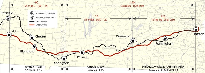
Passenger Train Classes                                                             ○   Regional Intercity Service operates with moderate frequency,
Passenger rail service can generally be classified as either commuter                   station stops 10 to 50 miles apart, maximum runs of 700 miles,
                                                                                        and a maximum speed of 125 mph. A high proportion of trips
rail or intercity passenger rail, which in turn has different levels of
                                                                                        are for business and personal/recreational travel. Of the rail
service. All of these types of service can be found in the East – West
                                                                                        services in the East – West corridor, only the Washington, DC
study corridor, although high-speed intercity service operates only
                                                                                        to St. Albans, VT Vermonter service and 9 Regional Service
peripherally in the corridor.
                                                                                        round trips serving Back Bay and South Station are regional
•   Commuter Rail: Commuter rail service is a more frequent type of                     intercity service. A new East-West service would also fall within
    service that connects many urban and suburban stations to a large                   this category, as would the Boston North Station–Portland–
    city center, with a range that corresponds to the size of the central               Brunswick, ME Downeaster service discussed in this study.
    city. As the name implies, a high proportion of riders are typically            ○   Long-Distance Intercity Service operates less frequently
    commuting daily to jobs in the city center. The MBTA operates                       (with only one or a few daily trips, station stops 15-75 miles
    commuter rail service on the Worcester/Framingham line between                      apart, and maximum runs of 2,800 miles and maximum speeds
    Worcester Union Station and Boston South Station. This service                      up to 110 mph. A high proportion of passengers use these
    operates with high frequency, station stops 1 to 5 miles apart, and                 services for personal/recreational travel. The Amtrak Lake
    maximum runs of 30 to 45 miles and maximum speeds of 80 mph.                        Shore Limited is an example of a long-distance intercity
    The CTrail Hartford Line is also commuter rail service. Commuter                    service.
    rail services typical receive public financial support to offset from
                                                                              Passenger Service Funding
    25% to 75% of the service’s operating costs.
•   Intercity Passenger Rail: Intercity passenger rail provides               As previously noted, the Rail Passenger Service Act of 1970 created
    connections among different urban centers, with longer distances          Amtrak to provide nationwide passenger rail service. Amtrak receives
    between stops and lower frequency than commuter rail. Amtrak is           Congressional funding for some capital and operating costs, but it is also
    the principal national operator of intercity passenger rail in America,   responsible for covering costs through passenger fares. As part of
    though there are some state and public authorities that also directly     Amtrak’s legislatively-defined Long-Distance system, the Lake Shore
    operate or manage operation of the regional intercity services.           Limited operating expenses are absorbed by Amtrak, whereas both the
    ○ High-Speed Intercity Service, such as the Amtrak Acela,                 Vermonter and Amtrak-operated trains on the Hartford Line and the
          operates with frequent service, station stops 30 to 50 miles        Valley Flyer service are classified as “state-supported.” These services
          apart, a maximum line distance of 500 miles, and a top speed
                                                                              receive financial assistance from the states along their respective routes.
          of 160 mph. The highest portion of travel is business travel.
          This type of service only briefly shares tracks with the East –     Railroad Infrastructure
          West Corridor between Back Bay Station and South Station in         The following are definitions of a few specialized railroad infrastructure
          Boston.                                                             terms that are used in the following sections.

East-West Rail Final Report                                               Page 15                                                           January 2021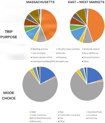
•   Railroad Bridges. Railroad bridges are a critical component of rail       Pittsfield – Boston Rail Line. The East – West Rail Corridor between
    infrastructure that separate railroad operations from conflicts with      Pittsfield and Boston is served by CSX Transportation (CSX), the
    obstacles such as water bodies or other transportation links, such as     MBTA Commuter Rail Framingham/Worcester Line, and Amtrak. This
    roadways or other railroads. The relative vertical position of railroad   section identifies all major physical, regulatory, and ownership
    bridges is also categorized as “undergrade” or “overhead” from the        opportunities and constraints, as well as recent changes, along the
    perspective of the train.                                                 Corridor. The key metrics for the Corridor are divided among the
    ○ Undergrade bridge. The railroad passes over an obstacle, such
                                                                              Corridor’s three main segments: the CSX-owned track from Pittsfield to
          as a roadway or water body.
                                                                              Springfield and from Springfield to Worcester, and the MassDOT-
    ○ Overhead bridge. The railroad passes underneath a bridge,
                                                                              owned segment between Worcester and Boston.
          such as a roadway viaduct.
•   Grade Crossing. A railroad grade crossing is a location where a           •   Rail Line Ownership and Control. CSX is the largest freight
    railroad and a roadway intersection “at-grade,” that is, at the same          railroad operating in Massachusetts and the largest private owner of
    level. Grade crossings, both for public and private roadways, can             rail property; CSX owns the segment of the East -- West Rail
    affect the safety and efficiency of freight and passenger rail service.       Corridor between Pittsfield and Worcester. A 2012 agreement
    Warning devices are employed at many at-grade crossings to                    transferred ownership and control of the balance of the corridor,
    identify the presence of the grade crossing. This equipment may               from Worcester to South Station in Boston, from CSX to the
    include passive signage such as crossing crossbucks, or active                Commonwealth of Massachusetts. As part of the agreement,
    systems, such as flashing lights and auditory signals, as well as             MassDOT and CSX collaborated on track and bridge improvements
    active barrier, gates that are lowered when a train is approaching.           to provide full double-stack vertical clearance (Plate H, 20’ 2”)
    New installations can now include vehicular and pedestrian intrusion          between the New York State line and a newly-expanded intermodal
    warning systems.                                                              terminal in Worcester, reducing transit times by as much as 24
•   Interlocking. An interlocking is a system of railroad infrastructure,         hours. In addition to the mainline improvements, CSX has made an
    such as a junction or crossing, along with associated signals and             investment of over $100 million in intermodal facilities in Worcester,
    switches, that enable trains to change tracks or cross other railroad         West Springfield, and Westborough that greatly benefit the
    tracks in a manner that is controlled and safe. PTC provisions have           Massachusetts economy. These investments have expanded
    added additional safety elements to control these movements.                  intermodal rail access to Massachusetts for freight shippers,
                                                                                  improving the competitiveness of freight rail in the Commonwealth.
3.3. East – West Corridor Transportation System                                   CSX continues to provide local freight service to Boston, and
The following is a summary of the key elements of the transportation              through Mansfield to South Coast destinations. The 2012 ownership
system that serves the East – West Corridor, with a particular focus on           transfer of the Worcester – Boston section to MassDOT enabled
the rail line connecting the East – West Corridor communities.                    a large-scale expansion of MBTA service as well as expansion of the
                                                                                  infrastructure such as the 3rd Main Track project and Allston

East-West Rail Final Report                                             Page 16                                                          January 2021
(Beacon Park) re-development. as sharp curvature just west of Worcester in Leicester and
• Track and Right-of-Way Conditions. Between Pittsfield and Charlton.
Boston, the East-West Corridor spans 151 miles. In general, the ○ The central section of the corridor historically featured two or
width of the railroad right-of-way decreases as one moves from west more tracks and typically offers 80 to 100 feet of width, with
to east; the western segment is up to 150 feet wide, while the occasional segments between 100 and 150 feet wide.
heavily-developed eastern segment can be as narrow as 50 feet, as ○ The highest maximum and average passenger speeds are
shown in Table 3-1. At one time the line had two or more main tracks attained along the passenger-heavy, fully double-tracked,
for the entire length. Western sections were single-tracked in the less curving segment between Worcester and Boston, which
1980s to help reduce the costs of replacing an obsolete signal permits passenger trains to travel up to 79 mph in sections.
system and rail infrastructure. The line is currently considered to be Most of the railroad alignment east of Worcester has right-of-
well-maintained by CSX and is the only route east of the Hudson way between only 50 and 80 feet wide.
River capable of hosting 315,000-lb. freight cars, the heaviest in • Geometric Challenges and Operational Obstacles. The
general use in the industry. topography of the terrain surrounding the rail alignment shapes the
railroad geometry, which has a major influence on train speed. In
Table 3-1 – Track and ROW Conditions by Major Segment addition to potential geometric issues, the presence of bridges and
interlockings requiring diverging operations can also affect the
SEGMENT DOUBLE- PASSENGER PERCENT
CORRIDOR ultimate performance and/or deliverability of a potential passenger
SEGMENT LENGTH TRACKED SPEEDS AT MAX
WIDTH (FT) service. Depending on the maximum operating speed desired,
(MI) (MI) (MPH) SPEED
the presence of sharp horizontal curves (i.e., those greater than 2
PIT – SPG 100-150 52 38.5 30-50 47%
degrees 30 minutes) may serve to limit the maximum speeds that
SPG – WOR 80-100 54 21 25-60 45%
can safely be achieved. Similarly, steep slopes in either direction
WOR – BOS 50-80 44 44 25-79 11%
(absolute vertical grades of one percent or greater) can negatively
○ Maximum authorized and average passenger speeds decrease impact the potential speed of rail operations, especially freight
as one moves east to west due to sharp track curvature and the operations. These constraints ultimately determine the rail corridor’s
difficult topography of the Berkshires and its river valleys. horizontal and vertical alignments and can make it economically
○ The Pittsfield to Springfield section offers the widest right- difficult to significantly increase maximum speeds.
of-way (ROW), but passage alongside the Westfield River, ○ As seen in Table 3-2 on the next page, the Pittsfield to
declared a part of the National Wild and Scenic River System, Springfield segment has the highest density of sharp horizontal
effectively prevents utilizing much of it. Maximum and average curves. These curves are to traverse the significant grades
passenger speeds along the Springfield to Worcester segment formed by the Berkshire Mountains, which carry the railroad
are higher, but still constrained by engineering maintenance alignment to a maximum elevation of 1,460 ft. above sea level
criteria to support the very heavy freight volumes, as well in the Town of Washington. The curves enable the railroad
East-West Rail Final Report Page 17 January 2021alignment to follow lower grades that cannot be achieved Table 3-3 – At-Grade Crossings by Major Segment and Type
by only following a straight track alignment. Multiple sharp
curves cannot be avoided in this segment. Notably, the railroad SEGMENT PUBLIC PRIVATE PEDESTRIAN TOTAL
alignment crosses the Westfield River 22 times in this section PIT – SPG 5 15 1 21
to maintain reasonable grades. SPG – WOR 0 7 0 7
○ From Springfield to Worcester, the Corridor is more level and WOR – BOS 4 1 5 10
features fewer horizontal curves less than five degrees; most TOTAL 9 23 6 38
of those sharp turns are located in Charlton or Spencer. In
this section of the corridor, there are nine major bridges over • Passenger Rail Capacity and Demand. The MBTA operates 27
the Quaboag River and several smaller bridges over other weekday round trips on the Framingham / Worcester Commuter
waterways. Rail Line, with 20 of those round trips providing service west of
○ The Worcester to Boston segment is comparatively straight Framingham to the western terminus at Worcester Union Station,
and unimpeded, with only five bridges over the Charles River, while Amtrak operates one 1 daily round trip between Boston and
Muddy River, and Sudbury River. Albany / Chicago. East of Worcester, the MBTA’s preliminary
Table 3-2 – Geometric Challenges and Obstacles by Major Segment analysis of capacity along the Worcester Line indicates that
any increase in peak service would require implementing the
SHARP STEEP BRIDGES Worcester Triple Tracking project described in Chapter 2. At the
INTER-
SEGMENT CURVES SLOPES (UNDERGRADE / line’s eastern terminus, South Station is already at capacity during
LOCKINGS
( > 2°30’ ) ( > 1% ) OVERHEAD) peak hour service and will remain heavily constrained until the
PIT – SPG 59 6 67 (50 / 17) 9 South Station Expansion project is implemented. In addition to
SPG – WOR 20 1 84 (50 / 34) 14 expanding terminal capacity to meet future high-speed, intercity,
WOR – BOS 21 0 100 (27 / 73) 16 and commuter rail service needs, this effort would also increase
layover capacity on the eastern end.
• Grade Crossings. Railroad grade crossings are critical to the
• Freight Rail Capacity and Demand. Shipping freight by rail
safety of the rail line and the roadways that cross it. The fewer
rather than by truck reduces truck traffic and highway congestion,
grade crossings, and the greater the level of protection at the
reduces greenhouse gas emissions by an estimated 75 percent2,
grade crossings that do exist, the lower the risk of collisions. Grade
and provides an additional shipping option for Massachusetts
crossings by type along each of the three major Boston – Albany
businesses. The segment of the Boston Main Line between
mainline rail segments are shown in Table 3-3.
Pittsfield and Worcester constitutes a core route for CSX’s system
freight movements, and freight rail demand in the corridor is likely
2
Association of American Railroads, “Freight Rail & Preserving the Environment,” July to increase, consistent with projections that overall freight
2020.
East-West Rail Final Report Page 18 January 2021movement in Massachusetts is expected to increase by 31 percent the design, operational speed, or capacity of the existing
between 2013 and 2040.3 The CSX freight line is one of the system. CSX and the MBTA have implemented two different
few freight railroad lines in Massachusetts that can handle the PTC systems for their respective areas of jurisdiction; CSX has
current freight rail industry standard of 286,000 lb. railcars, and the implemented the Interoperable Electronic Train Management
only one capable of handling 315,000 lb. railcars. In 2018, CSX System (I-ETMS) between Pittsfield and Worcester, while
regularly operated 14 through freight trains each day, along with the MBTA uses the Advanced Civil Speed Enforcement
additional freight trains based on shipper demand and locals. CSX System (ACSES) between Worcester and Boston. CSX, the
has handled approximately 140,000 freight loads per year in the MBTA, and Amtrak have completed implementation of the
Worcester intermodal facility, either originating from or destined infrastructure and operating systems required for PTC, and
to Commonwealth customers. Waybill sample data for 2016 expect their systems to be fully operational by the end of 2020.
confirms that the CSX mainline between the New York State line For any trains operating in both CSX and MBTA jurisdictions,
and Worcester carries by far the most tonnage of any rail line in the locomotive will need both systems to safely operate. This
Massachusetts and within New England, as shown in Figure 3-2. includes both passenger trains operating west of Worcester
Figure 3-2 – 2016 Freight Rail Volumes (FRA Waybill Sample Data) and freight trains operating east of Worcester.
• Passenger Rail Stations. The large cities on the East –
West Rail Corridor – Pittsfield, Springfield, Worcester, and
Boston (3 stops) – currently have passenger rail stations that
could be served by East – West trains, although some would
require improvements. Two other potential station locations,
Chester and Palmer, had train stations along the rail line in
the past, but those are no longer extant and would require
new stations. Amtrak’s long-distance Lake Shore Limited
intercity service between Boston and Chicago has stops in
Pittsfield, Springfield, Worcester, Framingham, and Boston.
• Positive Train Control (PTC). PTC is a rail safety overlay system Additional stations along the Worcester to Boston segment are
that works with on-board train control and railroad signal and used by MBTA, with local and express commuter rail service
communication systems to prevent trains from colliding, operating between those cities and numerous intermediate points. South
at excessive speeds through curves, and provide worker protection Station and Worcester Station are the terminal stations of the
when track construction or maintenance is underway. PTC provides segment, and the terminal stations for current MBTA commuter
additional operational safety features and only moderately changes rail service. Table 3-4 on page 21 provides key information for
each of these stations related to platforms, ownership of the
3
Freight Analysis Framework (Bureau of Transportation Statistics/ Federal Highway
Administration), per 2018 Massachusetts State Rail Plan. various elements, on-site parking capacity, ADA accessibility,
East-West Rail Final Report Page 19 January 2021and connections to other public transportation services. These The City of Springfield demolished the large, abandoned
represent current conditions, and do not necessarily reflect future baggage/station building on the north end of the site, and in
conditions that would be in place when an East – West 2017 completed the construction of a large parking garage
passenger rail service could be in operation. with 377 parking spaces and a 24-bay bus terminal on the
○ Joseph Scelsi Intermodal Transportation Center (ITC) site. The station is served by Greyhound and Peter Pan
is a transportation facility located in downtown Pittsfield, intercity buses and PVTA local buses.
Massachusetts. The ITC is served by Amtrak’s Lake Shore ○ Palmer historically had a station located in the town center east
Limited service and is owned and managed by the Berkshire of the intersection of the CSX and NECR mainlines. The station
Regional Transit Authority (BRTA). The ITC provides a waiting was abandoned and the old station building now functions as a
area for passengers who then descend to track level to board restaurant. Three tracks are located to the north and one to the
their trains. There is a one low-level side platform facing one of west of the historic station. Currently there is no active station
the line’s two tracks. Accessible platforming is provided by facility, and the location is not served by passenger rail service.
wheelchair lift. Amtrak does not provide ticketing or baggage The Amtrak Lake Shore Limited service passes through Palmer
service at the station. The ITC is also served by Greyhound and but does not stop. The station site is located on right-of-way
Peter Pan intercity buses and local BRTA buses. Parking is owned by CSX. There is also an important interlocking which
available at a 132-space parking lot. has its switching and signal facilities within the Palmer station
○ Chester has a former station building located on Prospect site. This arrangement did not exist when the station was
Street in the town center, but there is currently no active station originally constructed and would substantively complicate the
facility and no passenger rail service. The historic station siting of a new station in the same location.
building now houses the Chester Railway Museum, which is ○ Worcester Union Station is a passenger rail station located in
owned and managed by the Chester Foundation Inc. Two CSX- downtown Worcester at Washington Square. The station is
owned railroad tracks pass to the west of the historic station served by MBTA’s Framingham/Worcester Commuter Rail Line
building; there are no remaining platforms at the site. and Amtrak’s Lake Shore Limited service. The station is owned
○ Springfield Union Station, in downtown Springfield, is served and managed by the Worcester Redevelopment Authority. The
by Amtrak’s Lake Shore Limited, Vermonter, New Haven to station features a high-level platform on one side, which is ADA-
Springfield Shuttle, and limited Regional Service trains as well compliant, large headhouse with passenger waiting and
as the CTrail Hartford Line commuter service. The station is ticketing areas, retail and food vendors, and public safety
owned and managed by the Springfield Redevelopment facilities. A central high-level boarding platform is currently in
Authority. The station has four low-level platforms that are design to further improve the ADA accessibility requirements
accessible by wheelchair lift and a new high-level boarding and to improve the operational capabilities. The station has a
platform, which opened in early 2020, that provides a fully ADA- 500-car garage. The station is also served by Greyhound and
compliant platform.
East-West Rail Final Report Page 20 January 2021Table 3-4 – Passenger Rail Stations: Boston to Pittsfield
COMPONENT / SOUTH
PITTSFIELD CHESTER SPRINGFIELD PALMER WORCESTER FRAMINGHAM BACK BAY
STATION STATION
PLATFORM High Level (1 Low and Mini
Low level N/A Low level N/A High Level High Level
TYPE side) High Level
OWNERSHIP
FACILITY BRTA N/A Amtrak N/A WRA MBTA MBTA MBTA
PLATFORM BRTA N/A Amtrak, CSX N/A WRA MBTA MBTA MBTA
TRACK CSX CSX Amtrak, CSX Amtrak, CSX WRA MBTA MBTA MBTA
Springfield
City of City of
PARKING None Redevelopment N/A MBTA N/A N/A
Pittsfield Worcester
Authority
PARKING 132 N/A 377 N/A 500 166 None 226
Platform,
Platform, Platform, restrooms, Platform, Platform,
restrooms,
ACCESSIBILITY wheelchair N/A waiting room, wheelchair N/A restrooms, Platform restrooms,
waiting room,
lift lift waiting room waiting room
ticket office
CTrail Hartford Line, MBTA commuter MBTA commuter MBTA MBTA subway/
BRTA and
CONNECTIONS N/A Vermonter, NE Regional, N/A rail, WRTA bus, rail, and MWRTA subway/bus/ commuter rail,
intercity bus
PVTA bus, intercity bus and intercity bus bus commuter rail and intercity bus
Peter Pan intercity buses, Worcester Regional Transit Authority mini-high platform for each of the two tracks. The station meets
local buses, and shuttles affiliated with nearby institutions. ADA accessibility requirements. The station has a 166-space
○ Framingham Station is a passenger rail station located at parking lot and connections with local bus service and shuttles.
the intersection of Irving and Concord Streets in Framingham, ○ Back Bay Station, in the Back Bay neighborhood of Boston,
Massachusetts. The station is served by MBTA’s Framingham/ is served by three Amtrak services and four MBTA commuter
Worcester Commuter Rail Line and Amtrak’s Lake Shore rail routes. The station is owned and operated by MBTA. Back
Limited, and is owned and managed by the MBTA. Bay Station has five rail tracks and three platforms used by
Framingham Station has two low-level, at-grade platforms, Amtrak and MBTA Commuter Rail trains. Additionally, the
with access from various points on surrounding streets, and a MBTA Orange Line rapid transit service has two tracks and one
East-West Rail Final Report Page 21 January 2021center island platform. Local buses utilize a bus loop located on under the National Wild & Scenic Rivers System program; east
the eastern side of the station. Private shuttle buses also serve of Springfield, it follows the Quaboag River. Major changes or
the station. The station is ADA compliant, with fully accessible upgrades along the Corridor would have impacts to these protected
platforms and trains. resources, as well as the adjacent communities. Thus, rail corridor
○ South Station in downtown Boston is the largest passenger improvements for the East-West Passenger Rail service would
rail station in New England, serving three Amtrak services, require regulatory review and permitting at the federal, state, and
eight MBTA Commuter Rail routes, and the seasonal local level, particularly for work outside of the immediate railroad
CapeFlyer passenger rail service to Cape Cod. The MBTA right-of-way. Given the length of the Corridor, increasing
owns and maintains the transportation facilities at South passenger rail speeds would likely to require infrastructure
Station; Beacon Management owns and operates office space improvements that would trigger a NEPA filing beyond a
at the station. The station has thirteen tracks and seven Categorical Exclusion, along with various state and local permits.
platforms, passenger waiting and ticketing facilities, retail and • Operating Rights and Contractual Restrictions. Much of the
food vendors, and public safety facilities. It is also a major freight rail system operates on legacy corridors that are shared by
intermodal hub, with connections to the Red Line and Silver commuter and/or intercity rail passenger rail service for at least a
Line rapid transit lines, local bus routes, private shuttle bus portion of the route. Shared-use rail operations create challenges
routes, and intercity bus lines. In 2012, South Station served for operational capacity; scheduling and dispatch; the need for
roughly 128,000 daily boardings and alightings, including suitable track infrastructure (e.g. double-track and passing sidings)
Amtrak, MBTA Commuter Rail, Red Line, Silver Line, local and signal equipment; and speed mismatches between slower
bus, and intercity bus passengers. The station meets ADA freight trains and faster passenger trains. The principal conflict with
accessibility requirements, with fully accessible, level-boarding shared corridors comes when the combined use by passenger and
platforms and elevators. Parking is available at the South freight rail operators exceeds line capacity, including any capacity
Station Bus Terminal garage, located over the southern part of the freight railroad has reserved that is necessary for it to achieve
the site. The South Station rail terminal currently operates at its growth plans. Nevertheless, under federal law, Amtrak has the
capacity during peak hours, and the South Station Expansion right to provide passenger service on freight-owned lines, while the
project is required to accommodate additional passenger rail host railroad has the right to set the terms for an operating
service. agreement. The MBTA and MassDOT are not eligible to directly
• Environmental and Regulatory Constraints. Historic railroads utilize these legal provisions.
running through hilly or mountainous terrain frequently follow river
valleys to maintain their grade where possible. In the East-West
Corridor, much of the Boston-Albany mainline follows such river
valleys. Between Pittsfield and Springfield, much of the alignment
follows the Westfield River, which is afforded special protections
East-West Rail Final Report Page 22 January 2021Highway Network. The main highway connection for the Figure 3-3 – Traffic Volumes (AADT) at I-90 Interchanges (MassDOT, 2018 Road Inventory)
East – West Corridor is the I-90 corridor / Massachusetts
Turnpike. This express highway runs principally east –
west across Massachusetts and provides access to all the
Corridor communities, either directly or via a connecting
highway.
As shown in Figure 3-3, automobile volumes along
I-90 increase as one moves eastward towards Boston.
Beginning near Pittsfield and Lee, directional Annual
Average Daily Traffic (AADT) volumes increase around
Springfield, abruptly rise at the I-290/395 exit in Auburn/
Worcester, gradually increase through the communities
of MetroWest, and reach a peak between Route 128 and
the interchange serving Allston, Brighton, and Cambridge,
beyond which traffic volumes drop off. For Springfield and
Worcester, the congested highways connecting the urban
centers to I-90 serve more vehicles than I-90 itself.
This building congestion as one moves east on I-90 has
significant impacts on travel speeds and reliability of travel
times. Based on projections of 2040 travel times from
the Massachusetts Statewide Travel Demand Model, the Table 3-5 shows these factors for origin – destination pairs of the major cities in the
effects of this congestion were assigned a “peak direction East – West Corridor.
travel time factor.” Table 3-5 – Peak Travel Time Indices (AM or PM Peak / Off-Peak)
ORIGIN (ROWS) /
PIT SPG WOR BOS
DESTINATION (COLUMNS)
PIT 1.12 1.45 1.83
SPG 1.13 1.73 2.23
WOR 1.44 1.73 2.47
BOS 1.81 2.19 2.39
East-West Rail Final Report Page 23 January 2021These factors give the average amount by which the travel time for that in reliability occur for trips with one end located in Worcester or Boston.
trip increases during peak period congestion, compared with off-peak, Figure 3-4 shows typical travel times between the four major markets by
uncongested conditions. For example, in 2040, an automobile trip from automobile and passenger rail.
Pittsfield to Springfield during the morning peak period (which would be
Bus Service. Daily intercity bus service among the East – West Corridor
the peak congested direction) is expected to take 1.12 times as long as
markets is offered by two private service carriers: Greyhound and Peter
during uncongested conditions, while the afternoon peak period trip
Pan. Intercity bus stops are available at each of the rail stations in
from Boston to Worcester would be 2.39 times as long as an
Pittsfield, Springfield, Worcester, and Boston’s South Station. Frequent
uncongested trip.
weekday intercity bus connections are provided between the major
These travel time factors are an indicator of congestion levels and auto markets of Springfield, Worcester, and Boston. However, Pittsfield is
trip reliability. While auto travel times are relatively unaffected by peak served by only two weekday round trips to and from Springfield and
period congestion between Pittsfield and Springfield, significant shifts
Figure 3-4 – Travel Time Comparison – Passenger Rail versus I-90 Auto Trips
East-West Rail Final Report Page 24 January 2021Boston, and only weekday round trips to and from Worcester. While communities have been experiencing growth, some of the state’s historic
Boston is the dominant market, with 14 weekday round trips to and gateway cities have experienced stagnant or declining population,
from Worcester and 11 to and from Springfield, a relatively strong especially those farther west. Growth or decline in population and
connection is also provided between Springfield and Worcester, with employment can be attributed, in part, to access to jobs and economic
seven eastbound and eight westbound trips each weekday. These opportunity, as well as an increasing preference for urban living among
services include three eastbound and two westbound express bus some segments of the population. From a travel demand perspective,
trips each weekday between Springfield and Boston. One of the two the population and employment pull due to the Corridor’s four major
weekday round trips serving Pittsfield requires a bus-to-bus transfer. cities (Pittsfield, Springfield, Worcester, and Boston) are orders of
Based on the published schedules, intercity bus trips between Pittsfield magnitude greater than what would be produced or attracted in smaller
and Boston take approximately 3:40; however, if customers connect volume markets like Chester.
to the Springfield-Boston express service, it can be as short as three
This section focuses on population and employment trends recently
hours. Express trips between Springfield and Boston take approximately
published by Massachusetts Regional Planning Agencies (RPAs), along
1:45, while regular-stop trips take around two hours. Bus trips between
with data on Environmental Justice (EJ) communities. EJ communities
Worcester and Boston with local stops can take as long as two hours,
are those areas where the population has a higher level of low-income,
but there are many express trips that complete the trip in a single hour.
limited English proficiency (LEP), and/or federally-defined minority status
The Pittsfield – Springfield Boston bus route carries approximately 7,800
for racial and ethnic identity. These populations have long been subject
riders annually, while the Williamstown – Pittsfield – Springfield – Boston
to disproportionate burdens and deficient benefits from public projects
route carries approximately 7,100 riders annually;4 this corresponds to
and programs. It is therefore essential to track the location of these EJ
roughly 50 passengers per day on these bus routes.
populations to enable a better understanding of how a project’s benefits
3.4. Corridor Demographics and burdens affect these populations.
Demographic conditions and trends are critical to defining the mobility Note: Demographic information is given for Corridor communities based
needs and opportunities for communities along the East – West Corridor, on municipal boundaries, as well as for population within a radius of 20
as well as determining potential ridership for proposed passenger miles around Corridor stations. This second measure, population within
rail services. Many cities and urban centers in Massachusetts are a 20-mile radius of a station, corresponds to the people that are most
growing rapidly, in particular those located in the eastern part of likely to consider riding the East – West service; it is the population use
the Commonwealth. While Boston and its surrounding “inner core” for the ridership forecasting in the alternatives analysis. It includes the
4
MassDOT Rail & Transit Division, Regional Bus Network Assessment, 2016.
East-West Rail Final Report Page 25 January 2021population of all US Census tracts that have any portion within 20 miles Worcester, where it increases sharply. Population decreases to a
of the train station site. moderate level through the MetroWest suburbs, sharply increases
around Route 128, then increases significantly to a peak near Boston’s
Population. Based on US Census records, approximately 3.2 million
South Station.
people live within a 20-mile radius of Boston’s South Station, which
equates to nearly 47 percent of the Commonwealth’s total population.5 Employment. Based on the same RPA data and forecasts as those for
The second and third most populous travel markets in the East – West population, Figure 3-6 on page 28 shows estimates of 2020 employment
Corridor are Worcester with 836,000 residents and Springfield with and employment density, as well as anticipated change from 2020 to
675,000 residents within a 20-mile radius of those stations. Pittsfield 2040. The 2020 job density along the Corridor largely mirrors the pattern
is a substantially smaller market, with just under 129,000 residents found with population density: high or moderate in the cities and lower
within a 20-mile radius. When taken together, Pittsfield and Springfield in areas between the cities, with density increasing from west to east for
have a residential population of approximately 803,000 within a 20-mile these respective areas.
radius of their respective train stations, which is nearly equal to that for
By 2040, the greatest increase in employment is anticipated in Boston,
Worcester.
with 51,000 new through 2040 (an 8 percent increase). Moderate job
Based on recent municipal-level population forecasts from growth is projected in Worcester (2,450 jobs or 2 percent) over the 20-
Massachusetts RPAs, Figure 3-5 on the next page shows estimates of year period. However, the MPO forecasts anticipate minor employment
2020 population and population density, as well as anticipated change decreases in Springfield (-250 jobs or -0.3 percent) and Pittsfield (-900
from 2020 to 2040. Between 2020 and 2040, population is expected positions or -4 percent).
to increase within Boston, which is anticipated to add nearly 115,000
residents through 2040 (16 percent). Steady population growth is also
anticipated in Springfield (9,000 total or 6 percent) and Worcester (7,000
or 4 percent), and Pittsfield (3,350 or 7 percent).
Moving from west to east, 2020 population density is moderate in
Pittsfield, decreases to the lowest level in the Corridor between Pittsfield
and Springfield, then gradual increases to high density in downtown
Springfield. Population density decreases between Springfield and
5
US Census Bureau 2017 American Community Survey 5-Year Estimates at Block
Group level.
East-West Rail Final Report Page 26 January 2021Figure 3-5 – 2020 and 2040 Population Data (Massachusetts RPAs) East-West Rail Final Report Page 27 January 2021
Figure 3-6 – 2020 and 2040 Employment Data (Massachusetts RPAs)

East-West Rail Final Report                                       Page 28   January 2021
Environmental Justice (EJ) Communities. EJ communities are                      Table 3-7 – EJ Community Type Data for Four Major Markets
those geographic areas with a residential population that meets certain
                                                                                        AREA        MINORITY      INCOME            LEP             EJ
thresholds set by the Massachusetts Executive Office of Energy and
                                                                                      PITTSFIELD       7.7%         28.0%          0.00%          28.0%
Environmental Affairs (EEA) relative to income, race and ethnicity,
                                                                                  SPRINGFIELD         37.8%         34.1%          6.5%           46.6%
and English-speaking status. Meeting any of the three criteria listed
                                                                                  WORCESTER           27.3%         15.4%          6.2%           30.9%
in Table 3-6 qualifies an area as an EJ community. These populations
                                                                                       BOSTON         41.6%         13.9%          5.9%           42.9%
are those most at risk of being denied appropriate benefits or bearing
                                                                                      STATEWIDE       32.1%         17.5%          4.4%           36.9%
disproportionate burdens from governmental decision-making on
policies, programs, and projects.
                                                                                3.5. Travel Patterns
Table 3-6 – Environmental Justice Community Types and Criteria
                                                                                The interaction between the transportation system and demographics
                                                 EJ CRITERION                   shapes the travel behavior and patterns for the Commonwealth and the
        COMMUNITY TYPE                                                          Corridor markets. These travel patterns in turn are critical to developing
                                            (>= 25% OF SEGMENT)
                                    Residents are minorities (i.e., not White   and evaluating the potential solutions to the rail passenger travel needs
MINORITY STATUS                                                                 in the Corridor. The following assessment of travel patterns is based on
                                    Alone and not Hispanic)
                                    Households have an annual median            data from the statewide household travel survey and identifies major
LOW-INCOME
                                    income
Business, or Shopping purposes typically ranged from 10 to 15 percent Mode Split. Residents of the East – West Corridor markets are more
of reported journeys. likely to travel by modes other than automobile, particularly along the
densely developed Worcester-Boston segment. While 70 percent of
Figure 3-7 – Trip Purpose and Mode Choice for Trips Among Corridor Markets
(2010 Statewide Household Travel Survey) trips reported in the Commonwealth were completed by automobile, the
share of automobile-based trips made by Corridor residents within a 20-
mile radius of the train stations was about 4.5 percentage points lower.
This is because the Corridor encompasses the Commonwealth’s largest
cities with the densest land uses, the most robust transit and multimodal
networks, and greater concentrations of lower-income, transit dependent
populations. As a result, Corridor residents are better able to substitute
Walking, Public Transit Rail, Public Transit Bus, or Biking for car-based
journeys. Compared to the statewide share of transit-based trips, the
tendency to use transit was 24 percent higher among Corridor residents,
with 10 percent of all trips taken by rail or bus.
Travel Demand Patterns. The following are key patterns and trends
related travel demand in the East – West Corridor, based on data from
the 2010 Statewide Household Travel Survey (HHTS) and the US
Census Bureau’s Longitudinal-Employer Household Dynamics (LEHD)
dataset.
• Statewide Travel Survey Patterns. Table 3-8 on the next page
shows the relative flow of residents living within 20 miles of a
Corridor train station for all trip purposes, based on the HHTS.
In general, attraction between the markets increases as the
distance separating them decreases. In terms of magnitude,
strong connections were observed between Worcester and Boston
(320,700 trips). Ties between Springfield and Worcester (24,400
trips) and Pittsfield and Springfield (16,300 trips) made up the
majority of the remainder. The following are some of the other travel
patterns identified.
East-West Rail Final Report Page 30 January 2021Table 3-8 – Relative Proportion of Travel Demand among the Corridor Markets Table 3-9 – Commute Trips as Proportion of All Trips between Corridor Markets
for All Trip Purposes (2010 MA Statewide Travel Survey) (2010 MA Statewide Travel Survey)
ORIGIN (ROWS) WORK TRIPS FROM AS WORK TRIPS TO AS
/ DESTINATION PIT SPG WOR BOS ALL SHARE OF ALL TRIPS SHARE OF ALL TRIPS
MARKET
(COLUMNS) BETWEEN CORRIDOR BETWEEN CORRIDOR
PIT 3%• More than half of the work trips (52 percent) originated in
Worcester, with 15 percent beginning in Springfield and 28
Table 3-10 – Relative Commute Flows among the Corridor Markets (US Census percent in Boston.
LEHD) • More than half of the work trips (58 percent) between Corridor
markets were bound for Boston, with 28 percent destined for
HOME (ROWS)
Worcester and 12 percent for Springfield.
/ WORK PIT SPG WOR BOS ALL
• Two percent of work trips were bound for Pittsfield, whose
(COLUMNS)
workers were responsible for five percent of commute trips
PIT 2% 1% 2% 5%
among the Corridor markets.
SPG 1% 5% 9% 15% • Given their proximity and Boston’s strong economy, the
WOR 0% 5% 47% 52% Worcester – Boston market pair accounted for nearly three
BOS 1% 5% 22% 28% quarters (69 percent) of commute trips.
ALL 2% 12% 28% 58% 100% • Springfield’s relatively strong employment connections (both
ways) with Worcester (10 percent) and Boston (14 percent)
Table 3-11 – Relative Employment Ties among the Corridor Markets as a Share suggest potential demand for enhanced travel connections.
of Total Employment (US Census LEHD) • Connections between Pittsfield and the Corridor markets made
up 7 percent of all commute trips (5 percent from Pittsfield, 2
WORK TRIPS TO WORK TRIPS FROM
percent to Pittsfield).
OTHER CORRIDOR OTHER CORRIDOR • The Boston-bound commutes from Worcester and Springfield
MARKET MARKETS AS SHARE MARKETS AS SHARE accounted for more than half (56 percent) of all commutes
OF ALL COMMUTES OF ALL COMMUTES TO between the Corridor markets.
FROM MARKET MARKET
Table 3-12 and Table 3-13 on the following page show how each
PITTSFIELD 19% 11%
Corridor market contributes to economic activity. The first table
SPRINGFIELD 14% 12%
shows the relative proportion of work location based on home
WORCESTER 31% 18%
location (i.e., 48 percent of residents living in other Corridor markets
BOSTON 4% 7%
who reported to work in Pittsfield came from Springfield). The
ALL 7% 7%
second table displays the relative proportion of home locations
based on work location (i.e., 8 percent of workers who commuted
from Springfield to other Corridor markets went to Pittsfield).
East-West Rail Final Report Page 32 January 20213.6. Issues and Opportunities
The following is a summary of the key issues and opportunities that the
existing conditions in the East – West Corridor present for developing
Table 3-12 – Relative Proportion of Worker Home Locations Based on
and evaluating potential East – West passenger rail infrastructure and
Employment Location (US Census LEHD) service options.
• New England has many passenger rail lines with robust service and
HOME (ROWS) / WORK
PIT SPG WOR BOS strong ridership, including both commuter rail and intercity passenger
(COLUMNS)
rail. However, since all Amtrak Northeast Corridor service was shifted
PIT 15% 3% 3% away from the Inland Route to the electrified Shore Line in 2004,
SPG ~48% 18% 16% passenger rail service for Pittsfield and Springfield has been limited
WOR ~18% 42% 81% to one daily round trip via the Amtrak Lake Shore Limited. Amtrak
BOS ~33% 43% 79% has reduced the frequency to three round trips per week due to the
ALL 100% 100% 100% 100% COVID-19 pandemic.
• Two potential corridors were identified for providing passenger rail
connections to the East – West service communities: the Boston –
Table 3-13 – Relative Proportion of Employment Location Based on Worker Albany rail mainline and the I-90/Massachusetts Turnpike corridors.
Home Location (US Census LEHD) Either corridor would require significant infrastructure improvements
HOME (ROWS) / to enable more frequent passenger rail service.
PIT SPG WOR BOS ALL • Boston -- Albany Rail Mainline
WORK (COLUMNS)
PIT 42% 18% 40% 100% ○ West of Worcester, this rail line is owned by CSX, the third
SPG 8% 33% 59% 100% largest freight railroad in North America and the largest
WOR 1% 10% 89% 100%
operating in New England. Implementing and operating
BOS 3% 19% 78% 100%
increased passenger rail in this corridor would require an
agreement for sharing the corridor.
ALL ~2% ~12% ~28% ~57% 100%
○ The section of the rail corridor west of Worcester has not been
maintained to the high levels required for frequent passenger
service, and it includes many segments where the second track
has been removed from the line: the 52-mile Springfield to
Pittsfield segment of the corridor includes 13.5 miles of single-
track rail alignment, and the Worcester to Springfield segment
includes mostly single-track rail alignment, with 33 miles of
single track and only 21 miles of double-track.
East-West Rail Final Report Page 33 January 2021○ East of Worcester, the rail line is owned by MassDOT and the Massachusetts can be a significant barrier, especially for
MBTA, and use principally for high-frequency commuter rail longer trips from the western part of the Commonwealth. Other
service on the Framingham/Worcester Line, which provides example corridors such as the 91-mile long Philadelphia to
28 inbound weekday trains, 26 outbound weekday trains. The New York corridor have very competitive rail service due to
track infrastructure in this segment is in very good physical large historic investments in rail infrastructure and high quality
condition, but is heavily used by existing rail traffic. service.
• I-90/Massachusetts Turnpike Corridor ○ Work-related travel accounted for about 30 percent of all trips
○ This corridor generally provides a straighter and wider among the cities in the East – West corridor.
alignment than the Boston – Albany rail mainline. ○ Work trips generally follow similar patterns to overall trips, with
○ The I-90 corridor currently provides no railroad infrastructure; the level of trip-making proportional to the size and proximity of
all new railroad infrastructure would need to be built. the cities.
○ The I-90 corridor does not provide direct access to existing
downtown train stations in the East – West Corridor
communities; new rail links would need to be provided, most
likely via short connecting segments on the Boston – Albany
mainline.
○ The I-90 corridor has significant width constraints inside of
Route 128/Interstate 95, and could not accommodate a new
passenger rail alignment in this segment.
• The East – West Corridor includes the communities with the highest
population and employment in each part of the Commonwealth:
western Massachusetts (Pittsfield and Springfield), central
(Worcester), and eastern (Boston).
• Travel Patterns – Based on the Massachusetts Statewide
Household Travel Survey, conducted in 2010 – 2011.
○ Of all trips among the four major cities in the Corridor, a large
majority are between Worcester and Boston. This is likely due
to the fact that these are the largest cities in the
Commonwealth; there are more travel options, including
frequent commuter rail service; Pittsfield and Worcester
are significantly farther from Boston, the largest population and
employment center; and highway congestion in eastern
East-West Rail Final Report Page 34 January 2021You can also read