Finding of Adverse Effect for the South Fork Wind Farm and South Fork Export Cable Construction and Operations Plan August 2021 - U.S. Department ...
←
→
Page content transcription
If your browser does not render page correctly, please read the page content below
Finding of Adverse Effect for the
South Fork Wind Farm and
South Fork Export Cable
Construction and Operations Plan
August 2021

U.S. Department of the Interior
Bureau of Ocean Energy Management
Sterling, Virginia
Contents
1    Introduction .......................................................................................................................................................... 1
2    Project Overview .................................................................................................................................................. 2
    2.1         Background .............................................................................................................................................. 4
    2.2         Undertaking.............................................................................................................................................. 4
    2.3         Area of Potential Effects .......................................................................................................................... 6
          2.3.1            Marine Archaeological Resources Area of Potential Effects ......................................................... 6
          2.3.2            Terrestrial Archaeological Resources Area of Potential Effects .................................................... 7
          2.3.3            Area of Potential Effects for Visual Effects Analysis ...................................................................... 7
3    Steps Taken to Identify Historic Properties .......................................................................................................... 9
    3.1         Technical Reports ..................................................................................................................................... 9
    3.2         Consultation and Coordination with the Parties and the Public ............................................................ 14
          3.2.1            Early Coordination ....................................................................................................................... 14
          3.2.2            National Environmental Policy Act Scoping and Public Hearings ................................................ 14
          3.2.3            National Historic Preservation Act Section 106 Consultation ...................................................... 15
4    Application of the Criteria of Adverse Effect ...................................................................................................... 20
    4.1         Adversely Affected Historic Properties .................................................................................................. 20
          4.1.1            Assessment of Effects to Historic Properties in the Viewshed Area of Potential Effects ............ 22
          4.1.2            Assessment of Effects to Historic Properties in the Marine APE ................................................. 26
          4.1.3            Assessment of Effects to Historic Properties in the Terrestrial APE ............................................ 26
5    Measures to Avoid, Minimize, and Mitigate Adverse Effects ............................................................................. 27
    5.1         Avoidance ............................................................................................................................................... 27
    5.2         Minimization .......................................................................................................................................... 27
    5.3         Mitigation ............................................................................................................................................... 28
6    National Historic Landmarks and the NHPA Section 106 Process ...................................................................... 30
7    References Cited ................................................................................................................................................. 34

Appendices
Appendix A             Area of Potential Effects Map Figures
Appendix B             Map Figures of Historic Properties in Relation to the APE (Detached – Confidential)

                                                                                    i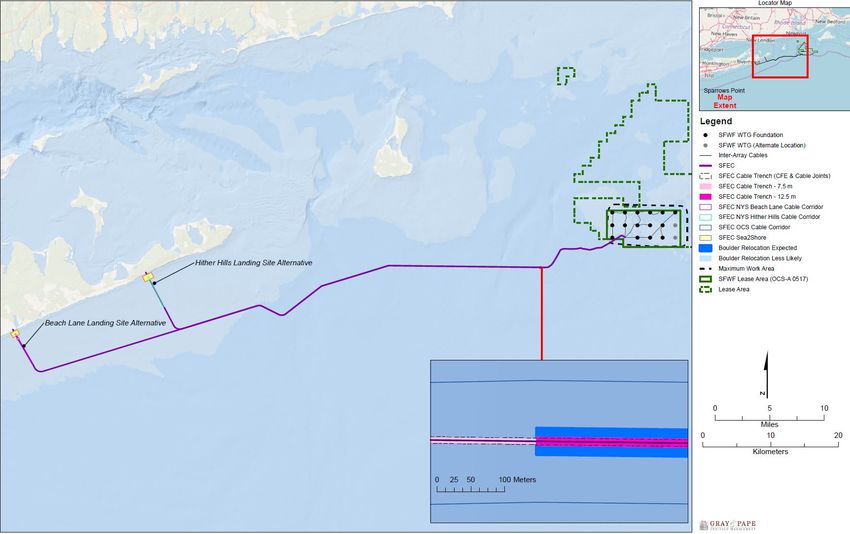
List of Figures
Figure 1. SFWF COP proposed Project elements. .......................................................................................................... 3
Figure 2. Comparative size of SFWF and BIWF WTGs with distance. .......................................................................... 25

List of Tables
Table 1. Description of Action Alternatives Reviewed in the EIS ................................................................................... 5
Table 2. Summary of Cultural Resources Investigations Performed by SFW in the Marine, Terrestrial, and
         Viewshed APEs ............................................................................................................................................... 10
Table 3. Parties Invited to Participate in NHPA Section 106 Consultation .................................................................. 15
Table 4. Consulting Parties Participating in NHPA Section 106 Consultation .............................................................. 17

                                                                                   ii
List of Abbreviations
ACHP         Advisory Council on Historic Preservation
ADLS         Aircraft detection lighting system
BIWF         Block Island Wind Farm
BOEM         Bureau of Ocean Energy Management
CFR          Code of Federal Regulations
CHRVEA       Cumulative Historic Resources Visual Effects Assessment
COP          construction and operations plan
Finding      finding of adverse effect
GIS          geographic information system
ha           hectare
HDD          Horizontal directional drilling
HRVEA        Historic Resources Visual Effects Assessment
km           kilometer
Lease Area   Area of BOEM Renewable Energy Lease Number OCS-A 0517
m            meter
MARA         Marine Archaeological Resources Assessment
MW           megawatt
MWA          maximum work area
MOA          memorandum of agreement
NEPA         National Environmental Policy Act
NHL          National Historic Landmark
NHPA         National Historic Preservation Act
nm           nautical mile
NOI          notice of intent
NPS          National Park Service
NRHP         National Register of Historic Places
O&M          operations and maintenance
OCS          Outer Continental Shelf
OSS          offshore substation
PDE          project design envelope
Project      South Fork Wind Farm and South Fork Export Cable Project
RI-MA WEAs   Rhode Island-Massachusetts Wind Energy Areas
ROW          Right-of-way
SFEC         South Fork Export Cable
SFW          South Fork Wind, LLC
SFWF         South Fork Wind Farm
SHPO         State Historic Preservation Officer
Tribes       Native American Tribes
WTG          wind turbine generator

                                                    iii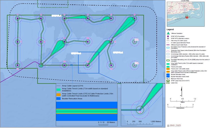
1 Introduction
The Bureau of Ocean Energy Management (BOEM) has made a finding of adverse effect (Finding), for
the South Fork Wind Farm (SFWF) and South Fork Export Cable (SFEC) Project (the Project) pursuant
to 36 CFR 800.5, in compliance with Section 106 of the National Historic Preservation Act (NHPA) (54
USC 306108). The SFWF is in the Rhode Island-Massachusetts Wind Energy Areas (RI-MA WEAs) and
the SFEC connects to New York (NY). BOEM finds that implementation of the Project would adversely
affect the 10 historic properties listed below, introducing visual effects and adding to cumulative visual
effects from wind turbine generator (WTG) visibility.
    •   Block Island South East Lighthouse (National Historic Landmark [NHL]), RI
    •   Old Harbor Historic District (National Register of Historic Places [NRHP] listed), RI
    •   Spring House Hotel (NRHP eligible), RI
    •   Spring House Hotel Cottage (NRHP eligible), RI
    •   Spring Street Historic District (NRHP eligible), RI
    •   Capt. Mark L. Potter House (NRHP eligible), RI
    •   Vaill Cottage (NRHP eligible), RI
    •   Gay Head Light (NRHP listed), MA
    •   Gay Head – Aquinnah Shops (NRHP eligible), MA
    •   Vineyard Sound and Moshup’s Bridge Traditional Cultural Property (TCP) (NRHP eligible), MA

Additionally, in the COP, South Fork Wind, LLC (SFW) 1 has identified five ancient submerged landform
features on the Outer Continental Shelf (OCS) where SFEC cabling installation activities would not be
able to avoid physical disturbance, and, therefore, BOEM has determined the following five historic
properties would be adversely affected:
    •   SFEC-CF-3
    •   SFEC-CF-5
    •   SFEC-CF-7
    •   SFEC-CF-9
    •   SFEC-CF-13

1
 On November 7, 2018, Ørsted completed an acquisition of all of the equity of Deepwater Wind South Fork, LLC.
A new company, Ørsted US Offshore Wind, combines the two North American offshore wind developers. Ørsted
subsequently renamed the subsidiary as South Fork Wind, LLC; therefore, this document refers to SFW throughout.

                                                       1
2 Project Overview
On June 29, 2018, BOEM received the initial COP to develop a wind energy project within Commercial
Lease OCS-A 0517 (offshore RI) from SFW. In the most recent version of the COP, (submitted in 2020),
SFW proposes the construction, operation, and eventual decommissioning of the Project, with up to 15
offshore WTGs, an offshore substation (OSS), offshore and onshore cabling, an onshore substation, and
an onshore operations and maintenance (O&M) facility (Figure 1 [BOEM 2021a: Figure 1.2.1-1]). SFW
is utilizing a project design envelope (PDE) in its COP, which represents a reasonable range of design
parameters that may be used for the Project. In reviewing the PDE, BOEM is analyzing the maximum
impacting scenario that could occur from any combination of the contemplated parameters. BOEM’s
analysis and review of the PDE may result in the approval of a project that is constructed within that
range or a subset of design parameters within the proposed range.
For the SFWF, each of the up to 15 WTGs would have a nameplate capacity of 6 to 12 megawatts (MWs)
per WTG. In addition to the WTGs, there would be submarine inter-array cables connecting the WTGs
and an OSS mounted on a dedicated foundation or co-located with a WTG, all of which would be located
within Lease Area OCS-A 0517 (Lease Area), approximately 19 miles (30.6 kilometers [km]) southeast
of Block Island, RI, and 35 miles (56.3 km) east of Montauk Point, NY. The SFWF would also entail
construction of an onshore O&M facility that would be located onshore at either Montauk, NY, or
Quonset Point in North Kingstown, RI.
The SFEC is an alternating current electrical cable connecting the SFWF to the existing mainland
electrical grid in East Hampton, NY. The SFEC includes both offshore and onshore segments. Offshore,
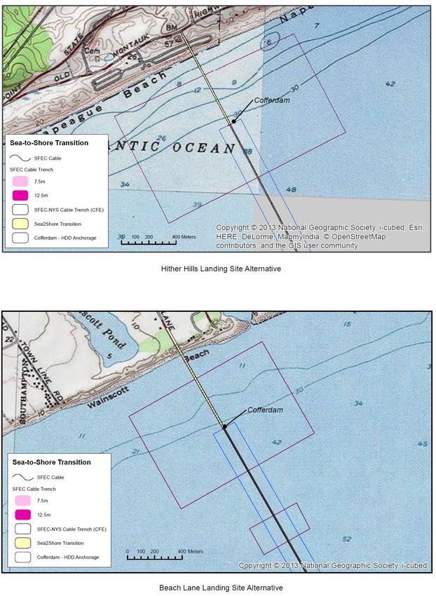
the SFEC would cross both federal OCS and NY waters. The SFEC would come to shore at landfall
locations in either the town of East Hampton or Hither Hills State Park in Montauk via a sea-to-shore
transition, where the offshore and onshore cables would be spliced together. The COP no longer proposes
a previously reviewed landfall location at Napeague State Park, NY, and this location is not being
analyzed for Project use by BOEM. The terrestrial underground segment of the export cable would be
located in East Hampton. The SFEC would also include construction of a new interconnection facility
where the SFEC would interconnect with the Long Island Power Authority electric transmission and
distribution system in East Hampton.
If approved by BOEM, SFW would be allowed to construct and operate offshore WTGs, an export cable
to shore, and associated facilities for a specified term. BOEM is now conducting its environmental and
technical reviews of the COP and has published a draft environmental impact statement (EIS) under the
National Environmental Policy Act (NEPA) for its decision regarding approval of the plan (BOEM
2021a). The EIS information for the Project, including the revised COP, are available at
https://www.boem.gov/renewable-energy/state-activities/south-fork. The EIS considers reasonably
foreseeable impacts of the proposal, specifically analyzing impacts to cultural resources, including
historic properties. BOEM is in the process of completing the final EIS on the Project at the time of this
Finding release, and the Finding is consistent with final EIS information to date.
2Figure 1. SFWF COP proposed Project elements.
Note: The named places on this figure in black font represent port, harbor, and terminal facilities considered in the COP for Project construction support.
32.1 Background
The Project is within a commercial lease area that has received previous Section 106 review by BOEM
regarding the issuance of the commercial lease and approval of site assessment activities and is subject to
two prior programmatic agreements (PAs): Programmatic Agreement Among The U.S. Department of the
Interior, Bureau of Ocean Energy Management; The State Historic Preservation Officers of
Massachusetts and Rhode Island; The Mashpee Wampanoag Tribe; The Narragansett Indian Tribe; The
Wampanoag Tribe of Gay Head (Aquinnah); and The Advisory Council on Historic Preservation;
Regarding the “Smart from the Start” Atlantic Wind Energy Initiative: Leasing and Site Assessment
Activities offshore Massachusetts and Rhode Island (http://www.boem.gov/MA-RI-PA-Executed) and
Programmatic Agreement Among The U.S. Department of the Interior, Bureau of Ocean Energy
Management, The State Historic Preservation Officers of New Jersey and New York, The Shinnecock
Indian Nation, and The Advisory Council on Historic Preservation Regarding Review of Outer
Continental Shelf Renewable Energy Activities Offshore New Jersey and New York Under Section 106 of
the National Historic Preservation Act (http://www.boem.gov/NY-NJ-Programmatic-Agreement-
Executed). In 2012, BOEM executed a PA among the State Historic Preservation Officers (SHPOs) of
MA and RI, the Advisory Council on Historic Preservation (ACHP), the Mashpee Wampanoag Tribe, the
Narragansett Indian Tribe, and the Wampanoag Tribe of Gay Head (Aquinnah) (see www.boem.gov/MA-
RI-PA-Executed) and concurrently conducted a Section 106 review of its decision to issue commercial
leases within the RI-MA WEAs.
Additionally, in 2016, BOEM executed a PA among the SHPOs of NY and New Jersey (NJ) and the
ACHP to consider renewable energy activities offshore NY-NJ (see www.boem.gov/NY-NJ-
Programmatic-Agreement-Executed). In 2013, BOEM prepared an environmental assessment to analyze
the environmental impacts associated with issuing commercial wind leases and approving site assessment
activities within the RI-MA WEAs; a commercial lease sale for RI was held later that year. SFW was the
winner of Lease OCS-A 0517 (under its current number designation). Subsequent to award of the lease,
SFW submitted a site assessment plan describing the proposed construction, operation, maintenance, and
decommissioning of a stand-alone offshore meteorological data collection system, which BOEM
reviewed under Section 106, resulting in the September 21, 2016, Finding of No Historic Properties
Affected for Approval of the Deepwater Wind Site Assessment Plan on the Outer Continental Shelf
Offshore Rhode Island (see www.boem.gov/Renewable-Energy-Program/State-Activities/HP/RI-SAP-
Finding.aspx).
2.2 Undertaking
BOEM has determined that approval, approval with modification, or disapproval of the COP constitutes
an undertaking subject to Section 106 of the NHPA and its implementing regulations (36 CFR 800) and
that the activities proposed under the COP have the potential to affect historic properties. Detailed
information about the Project, including the COP and its appendices, can be found on BOEM’s website
(see https://www.boem.gov/renewable-energy/state-activities/south-fork). Confidential appendices to the
COP referenced in this document, and their revisions, were provided to all consulting parties beginning
June 29, 2020. The COP, as well as its public and confidential appendices, is hereby incorporated by
4reference. BOEM has coordinated its NHPA Section 106 and NEPA reviews pursuant to 36 CFR
800.8(a). The Section 106 and NEPA reviews included three action alternatives as described in the EIS 2
(Table 1) – this Section 106 review analyzes the potential effects of all three action alternatives.
Table 1. Description of Action Alternatives Reviewed in the EIS
Alternative Description (from BOEM 2020)
Proposed Action Under this alternative, the construction and installation, O&M, and conceptual
alternative decommissioning of up to 15 WTGs in the 6- to 12-MW range, an OSS within the Lease
Area (including the expanded maximum work area for construction), and associated
export cables would occur within the range of design parameters outlined in the COP,
subject to applicable mitigation measures. SFW would space WTGs in a uniform east–west
and north–south grid with 1 × 1–nautical-mile (nm) spacing between WTGs and diagonal
transit lanes at least 0.6 nm wide. This configuration would still allow micrositing of WTGs
to avoid sensitive cultural resources and marine habitats.
Vessel Transit Lane Under this alternative, BOEM evaluated a 4-nm-wide vessel transit lane through the Lease
alternative Area where no surface occupancy would occur. BOEM developed this alternative in
response to the January 3, 2020, Responsible Offshore Development Association (RODA)
layout proposal (RODA 2020). The RODA proposal includes designated transit lanes, each
at least 4 nm wide. Although the proposal includes six total transit lanes, only one lane
intersects the Lease Area. The vessel transit lane is unique to this alternative and could
facilitate transit of vessels through the Lease Area from southern New England and
eastern Long Island ports to fishing areas in the region. WTGs located within the transit
lane would be eliminated under this alternative (however, up to 15 WTGs may still be
installed outside those lanes). SFW would develop the remaining WTGs with a 12-MW
capacity and would move the offshore substation north of the currently proposed location
and install it in one of the remaining WTG locations. The Transit alternative is within the
proposed design envelope of up to 15 WTGs in the 6- to 12-MW range.
Fisheries Habitat Under this alternative, the construction and installation, O&M, and conceptual
Impact Minimization decommissioning of WTGs, an OSS within the Lease Area, and associated inter-array and
alternative export cables would occur within the range of design parameters outlined in the COP,
(Preferred subject to applicable mitigation measures. However, to reduce impacts to complex
Alternative) fisheries habitats, as compared to the Proposed Action, BOEM would require SFW to
exclude certain WTGs and associated cable locations if micrositing is not possible to
maintain a uniform east–west and north–south grid of 1 × 1–nm spacing between WTGs
with diagonal transit lanes at least 0.6 nm wide. Under the Habitat alternative, BOEM may
approve fewer WTG locations than proposed by SFW.
2
For more information on the Final EIS, and the alternatives assessed, please see
https://www.boem.gov/sites/default/files/documents/renewable-energy/state-activities/SFWF%20FEIS.pdf.
52.3 Area of Potential Effects
Through consultation with the SHPOs during development of the above-referenced PAs and development
of BOEM’s Guidelines for Providing Archaeological and Historic Property Information Pursuant to 30
CFR Part 585 (guidelines), BOEM has defined the Area of Potential Effects (APE) for approval of a COP
to include the following geographic areas:
• the depth and breadth of the seabed potentially impacted by any bottom-disturbing activities,
constituting the marine archaeological resources portion of the APE;
• the depth and breadth of terrestrial areas potentially impacted by any ground-disturbing activities,
constituting the terrestrial archaeological resources portion of the APE;
• the viewshed from which renewable energy structures, whether located offshore or onshore,
would be visible, constituting the viewshed portion of the APE; and
• any temporary or permanent construction or staging areas, both onshore and offshore, which may
fall into any of the above portions of the APE.
Effects are only assessed to historic properties within the APE for the Project. This includes reasonably
foreseeable effects caused by the Project that may occur later in time, be farther removed in distance, or
be cumulative (36 CFR 800.5(a)(1)).
2.3.1 Marine Archaeological Resources Area of Potential Effects
The marine archaeological resources portion of the APE (hereafter marine APE) for the SFWF includes
the maximum work area (MWA) (Figure A-1 in Appendix A [Gray and Pape Inc. (Gray & Pape) 2020:
Figure 1-2]). The MWA encompasses all offshore areas where seafloor-disturbing activities from inter-
array cable trenching and installation, boulder relocation, and vessel anchoring may occur, up to a
maximum vertical extent of 15 feet (4.7 meters [m]) below the seafloor. SFW proposes up to 15 WTGs
and one OSS within the extent of the MWA. Each potential foundation location additionally includes a
1,312-foot (400-m) radius temporary foundation workspace that delineates the area where micrositing of
foundation positions may take place and where seafloor-disturbing impacts related to installation of the
monopole foundations may occur, up to a maximum vertical extent of 164 feet (50 m) below the seafloor.
The marine APE also includes the export cable and sea-to-shore transition (Figure A-2 in Appendix A
[Gray & Pape 2020: Figure 1-3]). The SFEC includes a 590-foot-wide (180-m-wide) corridor extending
from the Lease Area to the sea-to-shore transition at landfall locations in either the town of East Hampton
or Hither Hills State Park. Within this corridor, seafloor-disturbing activities related to cable installation
may occur, up to a maximum vertical extent of 15 feet (4.7 m). At the sea-to-shore transition, the APE
also includes workspaces where potential seafloor-disturbing activities associated with horizontal
directional drilling (HDD), installation of an offshore cofferdam, and vessel anchoring may occur. The
vertical extent of the APE within the sea-to-shore transition is 30 feet (9.1 m) below the seafloor.
Offshore construction would be supported by shipping port use (see Figure 1).
Marine archaeological resources (shipwrecks and ancient submerged landforms) situated in the marine
APE at the SFWF MWA and the SFEC corridor are depicted in Appendix B (Figures B-1 [Gray & Pape
2021: Figure 7] and B-2 [Gray & Pape 2021: Figure 6], respectively). Appendix B contains sensitive
6historic property location information and, for this reason, is confidential and detached from the publicly
available copies of the Finding.
2.3.2 Terrestrial Archaeological Resources Area of Potential Effects
The terrestrial archaeological resources portion of the APE (hereafter terrestrial APE) includes areas of
potential ground disturbance associated with installation of the onshore export cable (Figure A-3 in
Appendix A [provided by Environmental Design and Research (EDR)]). The sea-to-shore transition
would connect via HDD to an onshore underground transition vault (Figure A-4 in Appendix A). Ground-
disturbing activities from installation of the transition vault and associated HDD would occur at the Beach
Lane landing alternative within a 1.8-acre (0.7-hectare [ha]) parcel at the terminus of Beach Lane in the
town of East Hampton or at the Hither Hills beach landing alternative within a 0.14-acre (0.06-ha) parcel
located at Hither Hills State Park. Other landing site alternatives in the COP are not under BOEM
consideration (see Figure A-4). From the transition vault at either of the beach landing alternatives, SFW
would install the onshore export cable underground within a 4-foot-wide (1.2-m-wide) × 8-foot-deep (2.4-
m-deep) utility trench. The onshore cable alignment for either the Beach Lane route or the Hither Hills
route would be located within both existing public road rights-of-way (ROWs) and the existing Long
Island Railroad ROW. The onshore cable would connect to the proposed onshore substation parcel
located adjacent to the existing East Hampton Substation on Cove Hollow Road, East Hampton. Ground-
disturbing activities associated with construction of the new substation would occur within a 2.4-acre
(0.97-ha) parcel. See Figure A-5 for an overview map with the onshore substation parcel and O&M
facility boundaries showing the terrestrial APE. Confidential Appendix B depicts these areas in more
detail.
The terrestrial APE also includes areas of potential ground disturbance associated with construction of the
O&M facility. Two alternative locations are under consideration: a 338.6-acre (137-ha) parcel located
within the Quonset Business Park in the Town of North Kingstown, RI, or a 6.7-acre (2.7-ha) parcel
located at Montauk Harbor, East Hampton.
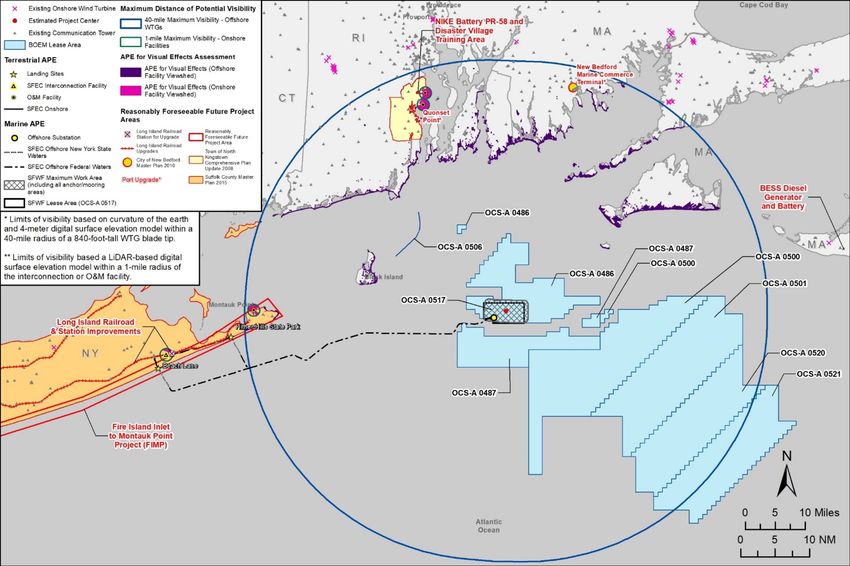
2.3.3 Area of Potential Effects for Visual Effects Analysis
The APE for visual effects analysis (hereafter viewshed APE) for the Project includes onshore coastal
areas of Long Island, NY, RI, and MA (Figure A-5 in Appendix A). Geographic information system
(GIS) analysis and subsequent field investigation delineated the viewshed APE methodically through a
series of steps, beginning with the maximum theoretical distance that WTGs could be visible (EDR
2021). This was determined by first considering the visibility of a WTG from the water level to the tip of
an upright rotor blade at a height of 840 feet. The analysis then accounted for how distance and curvature
of the Earth impede visibility as the distance increases between the viewer and WTGs (i.e., by a 40-mile
distance, even blade tips would be below the sea level horizon line). The mapping effort then removed all
areas with obstructed views toward SFWF WTGs, such as those views impeded and obscured by
intervening topography, vegetation, and structures. Areas with unobstructed views of offshore Project
elements then comprised the APE (see shaded “APE for Visual Effects” areas for the SFWF Offshore
Facility Viewshed on Figure A-5). Figure A-5 also depicts reasonably foreseeable future project areas for
consideration of cumulative effects within the APE (from BOEM 2021a: Figure E-10). Figure B-3 maps
the 10 properties that BOEM has determined would be subject to adverse effects in the viewshed APE.
7Additionally, the viewshed APE includes onshore visibility within a 1-mile area surrounding the proposed
onshore substation parcel and both O&M facility location alternatives at Quonset Point and Montauk
Harbor (Figure A-5). Historic properties in and near these Project facilities are depicted in Appendix B
(Figure B-4 [EDR 2018: Figure 9], Figure B-5 [EDR 2019a: Inset 3.1-1], and Figure B-6 [EDR 2019a:
Inset 3.1-2] in Appendix A).
83 Steps Taken to Identify Historic Properties
3.1 Technical Reports
To support the identification of historic properties within the APE, SFW has provided survey reports
detailing the results of multiple investigations within the marine, terrestrial, and viewshed portions of the
APE. Table 2 provides a summary of these efforts to identify historic properties and the results/key
findings of each investigation. BOEM has reviewed all reports summarized in Table 2 and found them to
be sufficient. BOEM found that the APE identified by SFW is appropriate for the magnitude, extent,
location, and nature of the undertaking. Further, BOEM has determined that the reports collectively
represent a good faith effort to identify and evaluate historic properties within the APE, they are sufficient
to apply the Criteria of Adverse Effect, and they support consultation with consulting parties regarding
the resolution of adverse effects to historic properties.
9Table 2. Summary of Cultural Resources Investigations Performed by SFW in the Marine, Terrestrial, and Viewshed APEs
Portion of Report Description Key Findings/Recommendations
APE
Offshore Marine Intensive geophysical This investigation included a high-resolution geophysical marine survey using
Archaeological and geotechnical magnetometer/gradiometer, side-scan sonar, multibeam echo-sounder, and both shallow
Resources archaeological study of and medium penetration sub-bottom profilers and subsequent archaeological vibracoring
Assessment - South the marine APE for the and geoarchaeological analysis. The survey resulted in identifying four shipwreck
Fork Wind Farm and SFWF, SFEC, and sea-to- archaeological sites within the SFWF MWA. No historic period marine archaeological
Export Cable, Rhode shore transition resources were identified within the footprint of the SFEC. The survey additionally identified
Island and New York a total of 21 ancient submerged landforms. Of these, eight features are recommended as
(Gray & Pape 2020) possessing higher probabilities for precontact site occurrence and preservation. Three
features are located within the SFWF MWA and five are located within the SFEC.
Offshore South Fork Wind Memorandum, most Eight ancient submerged landforms and features were recommended as having high
Farm and Export recently revised in June potential for precontact site occurrence, and avoidance is the preferred preservation
Cable Marine 2021, with updated measure for these features. SFW has evaluated its design and engineering options to avoid
Archaeological recommendations on or minimize potential effects to shipwrecks, potential shipwrecks, and ancient submerged
Resources avoidability of ancient landform features. All shipwrecks would be avoided. Three ancient submerged landforms
Assessment submerged landforms would be avoided at the SFWF, but five ancient submerged landform features at the SFEC
Addendum cannot necessarily be avoided. Note that although further investigation might be needed to
Memorandum (Gray evaluate the NRHP eligibility of these marine resources, BOEM has determined these
& Pape 2021) properties to be NRHP-eligible. The five ancient submerged landform features that cannot be
avoided by Project activities would be adversely affected.
10Portion of Report Description Key Findings/Recommendations
APE
Onshore Archaeological Assessment of The Quonset Point O&M facility site falls within the Quonset Business Park, which includes a
Assessment: archaeological potential NRHP-eligible property within its boundaries: the Quonset Point Naval Air Station. The
Operations and conducted for three Quonset Point Naval Air Station currently serves as a RI Air National Guard Base, an active
Maintenance alternative locations military base with modern structures and equipment. As a result of land development since
Facilities - South proposed for O&M the mid-twentieth century, the Quonset Point O&M facility site possesses low potential for
Fork Wind Farm facilities: two at intact/undisturbed archaeological resources. Although the proposed construction site falls
Rhode Island & New Quonset Point, RI, and within a known NRHP-eligible property, the potential for ground-disturbing activities to
York, U.S. (EDR one at Montauk Harbor, effect buried cultural resources is low because the area of proposed construction has been
2019b) East Hampton, NY previously disturbed and/or is fill material. The Montauk Harbor O&M facility site location
has no previously identified archaeological resources within it. This site was developed in the
mid-twentieth century as a working harbor and seafood operation and is currently occupied
by a small commercial fishing and packing business. As a result of the use of dredge fill in
some portions and land development from the mid- through late twentieth century overall,
this site possesses low potential for archaeological resources, as does the adjacent seabed
where additional dredging is proposed; therefore, no additional archaeological investigations
are recommended.
Onshore Phase I Phase I archaeological A Phase I archaeological survey was conducted for the onshore interconnection facility, SFEC
Archaeological survey for the onshore corridor, and SFEC landfall locations and alternatives. The survey included an archaeological
Survey for the South components of the SFEC sensitivity assessment of the potential upland routes of SFEC onshore, archaeological testing
Fork Export Cable - to identify terrestrial of two landing sites and routes, and the proposed onshore substation. No archaeological
Onshore Cable & archaeological sites sites were identified at the locations proposed for the substation landing sites or along the
Substation (EDR cable routes currently under consideration in the Project alternatives. Additional
2019c) archaeological testing was concluded necessary along the Beach Lane – Route A alternative,
the results of which are documented in the Phase IB archaeological survey report.
Onshore Phase IB Phase IB archaeological A Phase IB supplemental archaeological survey was conducted along the public roads of the
Archaeological survey to identify Beach Lane – Route A alternative. Investigations included hand excavation of shovel test pits
Survey: South Fork subsurface terrestrial within the grassy and unpaved portions of the road ROWs adjacent to the pavement.
Export Cable: Beach archaeological sites Systematic shovel tests were conducted for a portion of the Beach Lane – Route A
Lane - Route A (EDR alternative. No significant archaeological resources were identified.
2020a)
11Portion of Report Description Key Findings/Recommendations
APE
Onshore Historic Study identifying The visual effects analysis is based on the 1-mile-diameter circle around proposed onshore
and Architectural potential historic substation facilities. Within that circle, the APE was refined using GIS modeling of the
Viewshed Resources Survey: resources within 1 mile viewshed, which took into account the true visibility of the Project (e.g., visual barriers such
South Fork Export of the proposed new as topography, vegetation, and non-historic structures that obstruct the visibility of the
Cable Onshore onshore substation Project). The report identified 16 built resources within 1 mile of the proposed onshore
Substation (EDR located adjacent to substation. Resources included NRHP-listed, NRHP-eligible, and non-historic aboveground
2018) National Grid’s existing properties. Construction of the proposed onshore substation would not require the
East Hampton demolition or physical alteration of any aboveground historic properties, nor would its
substation construction result in a significant change in the existing visual character or scenic quality of
the 1-mile APE. Therefore, the proposed onshore substation would not have a negative
effect on the visual setting associated with historic architectural resources.
Viewshed Historic Resources Report analyzing the The visual effects analysis is based on the 1-mile-diameter circle around proposed onshore
Visual Effects viewsheds surrounding O&M facilities at the Montauk Harbor and Quonset Business Park/Quonset Point site
Analysis Operations the O&M facilities options. Within that circle, the APE was refined using GIS modeling of the viewshed, which
and Maintenance proposed for Montauk took into account the true visibility of the Project (e.g., visual barriers such as topography,
Facilities – South Harbor and Quonset vegetation, and non-historic structures that obstruct the visibility of the Project). At the
Fork Wind Farm Business Park/Quonset Montauk Harbor O&M facility site, the three historic properties in the APE for visual impact
Rhode Island & New Point analysis consist of one that is NRHP listed and two that are NRHP eligible. At the Quonset
York, US (EDR Business Park/Quonset Point O&M facility site, the one historic property within the APE for
2019a) visual impact analysis is NRHP eligible. The results of the viewshed analysis concluded that
the SFWF onshore support facilities would have negligible visual effects on the historic
resources located within the APE.
12Portion of Report Description Key Findings/Recommendations
APE
Viewshed Historic Resources Report analyzing the The visual impact analysis was based on the 40-mile-radius around the SFWF MWA, within
Visual Effects viewsheds from the which the extent of the APE was defined by the viewshed of WTGs using GIS modeling and
Analysis. Revised. WTGs and OSS through field observations, taking into account the true visibility of the Project (e.g., visual barriers
South Fork Wind GIS modeling to such as topography, vegetation, and non-historic structures that greatly reduce the visibility
Farm New determine the area of of Project WTGs). Modeling included an analysis of the visibility of a WTG from the water
York/Rhode Island, Project visibility and level to the tip of an upright rotor blade at a height of 840 feet and took into account how
US (HRVEA) (EDR define the APE for distance and curvature of the Earth affect visibility as space increases between the viewing
2021) historic properties point and WTGs. The HRVEA for the WTGs and OSS identified 113 historic properties in the
sensitive to visual viewshed APE. Of the 113 historic properties in the APE with potential views to the Project,
effects 39 are listed on the NRHP, of which seven are NHLs. The remaining 74 are considered eligible
for listing on the NRHP. Of these, 33 are in RI, and 41 are in MA. The revision also described
the range of resources with potential visibility and concluded that most of the properties
would not be adversely affected by the Project. Properties that EDR (2021) concluded to be
adversely affected consist of Block Island South East Lighthouse NHL, Gay Head Light, Gay
Head – Aquinnah Shops, The Breakers, Marble House, Bellevue Avenue Historic District,
Ocean Drive Historic District, Ocean Road Historic District, Capt. Mark L. Potter House, and
Vineyard Sound and Moshup’s Bridge TCP.
[Note: As described below, BOEM has determined that five of the properties that the HRVEA
identified along the mainland RI coast and Newport County would not be adversely affected.
BOEM has also found that additional properties would be adversely affected at Block Island,
where the HRVEA did not. Although the HRVEA identified five different historic properties
toward mainland RI where it considered adverse effects might result, BOEM has found no
adverse effects to The Breakers NHL, Marble House NHL, Bellevue Avenue Historic District
NHL, Ocean Road Historic District NHL, and Ocean Drive Historic District (NRHP listed).
BOEM’s assessment of effects is described in the Finding at 4.1.1 Assessment of Effects to
Historic Properties in the Viewshed Area of Potential Effects.]
13Consequent to the reports prepared for the COP submittal, SWCA Environmental Consultants (SWCA)
prepared a technical report for BOEM to support BOEM’s cumulative effects analysis, the Cumulative
Historic Resources Visual Effects Analysis – South Fork Wind Farm and South Fork Export Cable
Project (CHRVEA) (SWCA 2021a). The CHRVEA presents the analysis of cumulative visual effects
where BOEM has determined in its review of the Historic Resources Visual Effects Analysis. Revised.
South Fork Wind Farm New York/Rhode Island, US (HRVEA) (EDR 2021) that historic properties would
be adversely affected by the Project. The effects of other reasonably foreseeable wind energy
development activities are additive to those adverse effects from the Project itself, resulting in cumulative
effects. Ten historic properties in the offshore viewshed APE for the Project would be adversely affected,
and the addition of other reasonably foreseeable offshore wind energy development activities (see
Appendix E in the South Fork EIS) would result in cumulative effects to these ten properties. These 10
historic properties are Block Island South East Lighthouse NHL, Old Harbor Historic District, Spring
House Hotel, Spring Street Historic District, Spring House Hotel Cottage, Capt. Mark L. Potter House,
Vaill Cottage, Gay Head Light, Gay Head - Aquinnah Shops, and Vineyard Sound and Moshup’s Bridge
TCP.
3.2 Consultation and Coordination with the Parties and the Public
3.2.1 Early Coordination
Since 2009, BOEM has coordinated OCS renewable energy activities for the RI-MA WEAs with its
federal, state, local, and tribal government partners through its intergovernmental Renewable Energy Task
Force. BOEM has met regularly with federally recognized Native American Tribes (Tribes) that may be
affected by renewable energy activities in the area since 2011, specifically during planning for the
issuance of leases and review of site assessment activities. BOEM also hosts public information meetings
to update interested stakeholders on major renewable energy milestones. Information on BOEM’s RI-MA
Renewable Energy Task Force meetings is available at https://www.boem.gov/Massachusetts-Renewable-
Energy-Task-Force-Meetings, and information on BOEM’s stakeholder engagement efforts is available at
https://www.boem.gov/renewable-energy/state-activities/public-information-meetings.
3.2.2 National Environmental Policy Act Scoping and Public Hearings
On March 19, 2018, BOEM announced its notice of intent (NOI) to prepare an EIS for the SFW COP
(BOEM 2018). The purpose of the NOI was to solicit input on issues and potential alternatives for
consideration in the COP. Throughout the scoping process, federal agencies; state, tribal, and local
governments; other interested parties; and the public had the opportunity to help BOEM determine
significant resources and issues, impact-producing factors, reasonable alternatives, and potential
mitigation measures to be analyzed in the EIS as well as provide additional information. BOEM also used
the NEPA commenting process to allow for public involvement in the NHPA Section 106 consultation
process (54 USC 300101 et seq.), as permitted by 36 CFR 800.2(d)(3). Through this notice, BOEM
announced that it would inform its NHPA Section 106 consultation using the NEPA commenting process
and invited public comment and input regarding the identification of historic properties or potential
effects to historic properties from activities associated with approval of the SFW COP.
14Additionally, BOEM held public scoping meetings, which included specific opportunities for engaging on
issues relative to NHPA Section 106 for the SFW COP, at the places and dates listed below.
• Amagansett, NY; Monday, November 5, 2018
• New Bedford, MA; Wednesday, November 7, 2018
• Narragansett, RI; Thursday, November 8, 2018
Through this NEPA scoping process, BOEM received comments related to cultural, historic,
archaeological, or tribal resources. Comments indicated that the EIS should assess potential onshore
impacts to archaeological and historic resources at Project locations in NY (SWCA 2021b:9). BOEM’s
EIS scoping report includes these comments and is available at
https://www.boem.gov/sites/default/files/documents/renewable-energy/Scoping-Summary_0.pdf.
On January 8, 2021, BOEM published a notice of availability for the draft EIS for the COP submitted by
SFW. As part of this process, BOEM held public hearings Tuesday, February 9; Thursday, February 11;
and Tuesday, February 16, 2021. Due to COVID-19 restrictions, all of these public hearings were held
virtually. The public comment period closed on February 22, 2021. Comments received on the draft EIS
related to cultural, historic, archaeological, or tribal resources are similar to or reiterate those received
from consulting parties during NHPA Section 106 consultation. BOEM’s review and consideration of
comments received during scoping and on the draft EIS have informed this Finding and are not repeated
herein; those scoping and EIS documents are available at https://www.boem.gov/renewable-energy/state-
activities/south-fork. Comments received from consulting parties during NHPA Section 106 consultation
may contain sensitive information on the character and location of properties and BOEM is safeguarding
this confidential information as specified at 36 CFR 800.11(c)(1).
3.2.3 National Historic Preservation Act Section 106 Consultation
BOEM extended invitations to consult under NHPA Section 106 on review of the Project COP via letter
on May 29, 2019, to 40 potential consulting parties. Throughout spring 2020, as third-party consultant to
BOEM, SWCA followed up with these parties to confirm preferred points of contact and interest in
participating. The organizations BOEM invited to consult are listed in Table 3.
Table 3. Parties Invited to Participate in NHPA Section 106 Consultation
Participants in the NHPA Section 106 Process Invited Consulting Parties
SHPOs and state agencies RI Historical Preservation & Heritage Commission (RI SHPO)
NY State Division for Historic Preservation (NY SHPO)
MA Historical Commission (MA SHPO)
MA Board of Underwater Archaeological Resources
MA Commission on Indian Affairs
15Participants in the NHPA Section 106 Process Invited Consulting Parties
Federal agencies ACHP
National Park Service (NPS)
U.S. Army Corps of Engineers, New England District and NY
District
Federally recognized Tribes Wampanoag Tribe of Gay Head (Aquinnah)
Mohegan Tribe of Indians of Connecticut
Narragansett Indian Tribe
Mashantucket Pequot Tribal Nation
Mashpee Wampanoag Tribe
Shinnecock Indian Nation
Delaware Tribe of Indians
Delaware Nation
Non-federally recognized Tribes Chappaquiddick Tribe of the Wampanoag Nation
Unkechaug Nation
Local governments Town of West Tisbury, MA
Town of East Hampton and East Hampton Town Trustees,
NY
Town of Chilmark, MA
Town of Little Compton, RI
Town of Narragansett, RI
Town of New Shoreham, RI
Town of Newport, RI
Town of Aquinnah, MA
Town of Charlestown, RI
Town of Edgartown, MA
Town of Gosnold, MA
Town of Westerly, MA
Town of South Kingstown, RI
Town of Jamestown, RI
Cape Cod Commission, MA
16Participants in the NHPA Section 106 Process Invited Consulting Parties
Nongovernment organizations or groups Gay Head Lighthouse Advisory Committee
Southeast Lighthouse Foundation
Block Island Historical Society
Martha’s Vineyard Commission
Alliance to Protect Nantucket Sound
Montauk Historical Society
Preservation Massachusetts
SFW (Ørsted) (the applicant for federal approval)
On June 29, 2020, BOEM again contacted responsive governments and organizations in the list above,
providing information on the proposed undertaking, and re-extending the invitation to be a consulting
party to the NHPA Section 106 review of the COP. The information provided to consulting parties
beginning June 29, 2020, included technical reports listed in Table 2 that were prepared for historic
property identification in an appendix to the COP. Entities that responded to BOEM’s invitation or were
subsequently made known to BOEM and added as consulting parties are listed in Table 4.
Table 4. Consulting Parties Participating in NHPA Section 106 Consultation
Participants in the NHPA Section 106 Process Participating Consulting Parties
SHPOs and State Agencies RI Historical Preservation & Heritage Commission (RI SHPO)
NY State Division for Historic Preservation (NY SHPO)
MA Historical Commission (MA SHPO)
MA Board of Underwater Archaeological Resources
Federal Agencies ACHP
NPS
U.S. Army Corps of Engineers, New England District and NY
District
Federally Recognized Tribes Wampanoag Tribe of Gay Head (Aquinnah)
Mohegan Tribe of Indians of Connecticut
Narragansett Indian Tribe
Mashantucket Pequot Tribal Nation
Mashpee Wampanoag Tribe
Shinnecock Indian Nation
Delaware Tribe of Indians
Delaware Nation
17Participants in the NHPA Section 106 Process Participating Consulting Parties
Non-Federally Recognized Tribes Chappaquiddick Tribe of Wampanoag Nation
Unkechaug Nation
Local Governments Town of West Tisbury, MA
Town of East Hampton and East Hampton Town Trustees, NY
Town of Chilmark, MA
Town of Aquinnah, RI
Town of Little Compton, RI
Town of Narragansett, RI
Town of New Shoreham, RI
Nongovernment Organizations or Groups Gay Head Lighthouse Advisory Committee
Southeast Lighthouse Foundation
Block Island Historical Society
Newport Restoration Foundation
SFW (Ørsted) (the applicant for federal approval)
On January 15–17, July 21 and 27, and August 20, 2020; and on March 12 and April 9, 2021, BOEM met
with federally recognized Tribes to simultaneously discuss multiple BOEM actions, including about the
Project and taking into account the effects of Project on historic properties under NHPA Section 106; see
EIS Appendix A at Government-to-Government Consultation with Federally Recognized Indian Tribes.
The Mohegan Tribe of Indians of Connecticut, the Mashantucket Pequot Tribal Nation, the Narragansett
Indian Tribe, the Wampanoag Tribe of Gay Head (Aquinnah), the Mashpee Wampanoag Tribe, and the
Delaware Tribe of Indians participated in these meetings. BOEM continues to consult with these and
other Tribes on developments in offshore wind and the Project. Additional government-to-government
consultations are planned for the future.
In correspondence and subsequent consultation meetings, BOEM requested information from consulting
parties on defining the APE and identifying historic properties potentially affected by the proposed
undertaking. BOEM held an initial NHPA Section 106 consultation meeting with consulting parties by
webinar on September 29, 2020, reviewing the Project background and the identification of historic
properties, as presented in previously provided technical reports. On January 8, 2021, the CHRVEA was
distributed to consulting parties, and on February 26, 2021, updated copies of the CHRVEA, the SFEC
Phase 1B archaeological survey report, and the South Fork Wind Farm and Export Cable Marine
Archaeological Resources Assessment Addendum Memorandum (MARA addendum) (see Table 2) were
distributed to consulting parties. BOEM held a second NHPA Section 106 consultation meeting with
consulting parties by webinar on March 11, 2021, reviewing updated technical report information and the
agency’s preliminary adverse effect assessments. BOEM provided a revised CHRVEA and the draft
Finding to consulting parties beginning May 3, 2021, and Addendum 1 to the Finding beginning May 28,
2021. BOEM held the third NHPA Section 106 consultation meeting with consulting parties via webinar
on June 29, 2021, reviewing updates to technical reports since the last meeting, BOEM’s finding of
18effects, and next steps for resolving adverse effects. A meeting summary and access to a recording of the
meeting was made available to consulting parties following each meeting. BOEM provided a revised
MARA addendum to consulting parties on June 29, 2021, prior to distributing the final Finding.
BOEM plans to continue consulting with the SHPOs, ACHP, NPS, and the consulting parties to seek their
comments and input regarding the effects of the undertaking on historic properties and on the resolution
of adverse effects including the development and implementation of a memorandum of agreement
(MOA).
194 Application of the Criteria of Adverse Effect
The Criteria of Adverse Effect under NHPA Section 106 (36 CFR 800.5(a)(1)) states that an undertaking
has an adverse effect on a historic property when an undertaking may alter, directly or indirectly, any of the
characteristics of a historic property that qualify the property for the NRHP in a manner that would
diminish the integrity of the property’s location, design, setting, materials, workmanship, feeling, or
association. Adverse effects may include reasonably foreseeable effects caused by the undertaking that may
occur later in time, be farther removed in distance, or be cumulative (36 CFR 800.5(a)(1)). According to
the regulations (36 CFR 800.5(a)(2)), adverse effects on historic properties include, but are not limited to,
i. physical destruction of or damage to all or part of the property;
ii. alteration of a property, including restoration, rehabilitation, repair, maintenance, stabilization,
hazardous material remediation, and provision of handicapped access, that is not consistent with
the Secretary of the Interior’s Standards for the Treatment of Historic Properties (36 CFR 68)
and applicable guidelines;
iii. removal of the property from its historic location;
iv. change of the character of the property’s use or of physical features within the property’s setting
that contribute to its historic significance;
v. introduction of visual, atmospheric, or audible elements that diminish the integrity of the
property’s significant historic features;
vi. neglect of a property which causes its deterioration, except where such neglect and deterioration
are recognized qualities of a property of religious and cultural significance to an Indian Tribe
[Tribes] or Native Hawaiian organization; and
vii. transfer, lease, or sale of property out of federal ownership or control without adequate and
legally enforceable restrictions or conditions to ensure long-term preservation of the property’s
historic significance.
4.1 Adversely Affected Historic Properties
BOEM has determined that the undertaking would have an adverse effect on the following 10 historic
properties within the viewshed APE:
• Block Island South East Lighthouse (NHL), RI
• Old Harbor Historic District (NRHP listed), RI
• Spring House Hotel (NRHP eligible), RI
• Spring House Hotel Cottage (NRHP eligible), RI
• Spring Street Historic District (NRHP eligible), RI
• Capt. Mark L. Potter House (NRHP eligible), RI
• Vaill Cottage (NRHP eligible), RI
• Gay Head Light (NRHP listed), MA
• Gay Head – Aquinnah Shops (NRHP eligible), MA
• Vineyard Sound and Moshup’s Bridge TCP (NRHP eligible), MA
20Additionally, BOEM has determined that the undertaking would have an adverse effect on five historic
properties due to physical disturbance within the marine APE.
• SFEC-CF-3
• SFEC-CF-5
• SFEC-CF-7
• SFEC-CF-9
• SFEC-CF-13
Consulting parties have expressed that the view of the undeveloped ocean is integral to the character of
the Block Island South East Lighthouse NHL and Gay Head Light historic properties as well as other
Block Island historic properties, such as the Old Harbor Historic District (summarized in Addendum 1).
The Wampanoag Tribe of Gay Head (Aquinnah) and the MA SHPO have indicated that there exist
multiple cultural places and features potentially affected by the undertaking in relation to the Vineyard
Sound and Moshup’s Bridge TCP.
During consultation meetings, federally recognized Tribes, a historical MA Tribe, and a NY state-
recognized Tribe have stated that ancient submerged landforms are culturally significant resources as the
lands where their ancestors lived and as locations where events described in tribal histories occurred.
BOEM has determined these five ancient submerged landform features are individually eligible for listing
on the NRHP as sites (as in habitation sites and not archaeological sites). They are eligible under Criterion
A for their associations with the ancient Native American exploration and settlement of the continental
shelf, tied to the traditions of consulting tribes, and under Criterion D for the potential to yield important
cultural, historical, and scientific information through archeology, history, and ethnography about ancient
human opportunities for resource access, settlement, mobility, and land use prior to 8,000 BP. Consistent
with other findings for ancient submerged landforms in the RI-MA WEAs:
If archaeological resources are present within the identified ancient landforms and they
retain sufficient integrity, these resources could be eligible for listing on the NRHP under
Criterion D. During the last glacial maximum, at around 24,000 [years] before present
(B.P.), sea levels dropped approximately 55 to 26 m (180 to 85 ft) below today’s level.
Sea level did not reach a near modern level until approximately 3,000 [B.P.] in the New
England area. Consequently, a large amount of land on the OCS was exposed and existed
as terrestrial land during the late Pleistocene and early Holocene. Native American oral
histories and archaeological evidence demonstrate that Native American populations were
present in the New England region, over 160 km (86.89 nm) inland from the coast at the
time that the OCS was exposed. It is logical to assume that these people would have also
occupied the now-submerged landscape on the OCS. . . . Due to current technological
constraints, very little archaeological information has been recovered from Late
Pleistocene and early Holocene archaeological sites on the OCS. As a result, very little
archaeological material has been recovered related to Native American adaptations and
lifeways on the then coastal plain and coast. Any archaeological information preserved
within these sites, if present, would likely yield significant information important in the
pre-contact history of the region, making the sites eligible for NRHP listing under
Criterion D. (BOEM 2020:35)
21You can also read