Stibnite Gold Project - Draft Environmental Impact Statement August 2020 - Perpetua Resources
←
→
Page content transcription
If your browser does not render page correctly, please read the page content below
United States Department of Agriculture
Forest Service

Stibnite Gold Project
Draft Environmental Impact Statement
Forest Service, Region 4, Payette and Boise National Forests, Valley County, Idaho

August 2020
This page intentionally left blank
Lead Agency:                           USDA Forest Service

Cooperating Agencies:                  U.S. Army Corps of Engineers, U.S. Environmental Protection Agency, Idaho
                                       Governor’s Office of Energy and Mineral Resources,
                                       Idaho Department of Lands, Idaho Department of Environmental Quality, Valley
                                       County

Responsible Official:                  Linda Jackson, Forest Supervisor, Payette National Forest
                                       500 N. Mission Street, Building 2, McCall, Idaho 83638
                                       Phone: (208) 634-0700
                                       Email: linda.jackson@usda.gov

For Information Contact:               Brian Harris, Public Affairs Officer, Payette National Forest
                                       500 N. Mission Street, Building 2, McCall, Idaho 83638
                                       Phone: (208) 634-6945
                                       Email: brian.d.harris@usda.gov

Abstract:                              This Draft Environmental Impact Statement (EIS) is a public document that
                                       discloses the direct, indirect, and cumulative effects of the proposed action and
                                       alternative actions for the Stibnite Gold Project. This document follows the format
                                       established in the Council on Environmental Quality (CEQ) regulations (40 Code
                                       of Federal Regulations [CFR] Parts 1500–1508). It includes a discussion of the
                                       purpose and need for the proposal; alternatives to the proposal; the physical,
                                       biological, social and economic impacts of the proposed action and alternatives;
                                       and a listing of agencies and persons consulted. The document tiers to and
                                       incorporates by reference material in the Final EIS and record of decision (ROD)
                                       for the 2003 Land and Resource Management Plan (Forest Plan), as amended
                                       for the Payette National Forest, and the Final EIS and ROD for the 2010 Boise
                                       Forest Plan.

Submit Written Comments To:            Linda Jackson, Payette Forest Supervisor
                                       Stibnite Gold Project
                                       500 N. Mission Street, Building 2, McCall, Idaho 83638

Submit Electronic Comments To: https://cara.ecosystem-management.org/Public/CommentInput?Project=50516

Please state “Stibnite Gold Project” in the subject line when providing electronic comments, or on the envelope when
replying by mail. Electronic comments must be submitted in a common digital format such as plain text (.txt), rich
text format (.rtf), Word (.doc, .docx) or PDF (.pdf).

Project Website: https://www.fs.usda.gov/project/?project=50516

Cover Photo Credits: Yellow Pine pit. Midas Gold, Stibnite Gold Project Plan of Restoration and Operations
September 2016.

In accordance with Federal civil rights law and U.S. Department of Agriculture (USDA) civil rights regulations and
policies, the USDA, its Agencies, offices, and employees, and institutions participating in or administering USDA
programs are prohibited from discriminating based on race, color, national origin, religion, sex, gender identity
(including gender expression), sexual orientation, disability, age, marital status, family/parental status, income derived
from a public assistance program, political beliefs, or reprisal or retaliation for prior civil rights activity, in any program
or activity conducted or funded by USDA (not all bases apply to all programs). Remedies and complaint filing
deadlines vary by program or incident. Persons with disabilities who require alternative means of communication for
program information (e.g., Braille, large print, audiotape, American Sign Language, etc.) should contact the
responsible Agency or USDA’s TARGET Center at (202) 720-2600 (voice and TTY) or contact USDA through the
Federal Relay Service at (800) 877-8339. Additionally, program information may be made available in languages
other than English. To file a program discrimination complaint, complete the USDA Program Discrimination Complaint
Form, AD-3027, found online at http://www.ascr.usda.gov/complaint_filing_cust.html and at any USDA office or write
a letter addressed to USDA and provide in the letter all of the information requested in the form. To request a copy of
the complaint form, call (866) 632-9992. Submit your completed form or letter to USDA by: (1) mail: U.S. Department
of Agriculture Office of the Assistant Secretary for Civil Rights 1400 Independence Avenue, SW Washington, D.C.
20250-9410; (2) fax: (202) 690-7442; or (3) email: program.intake@usda.gov. USDA is an equal opportunity provider,
employer, and lender.

Stibnite Gold Project Draft Environmental Impact Statement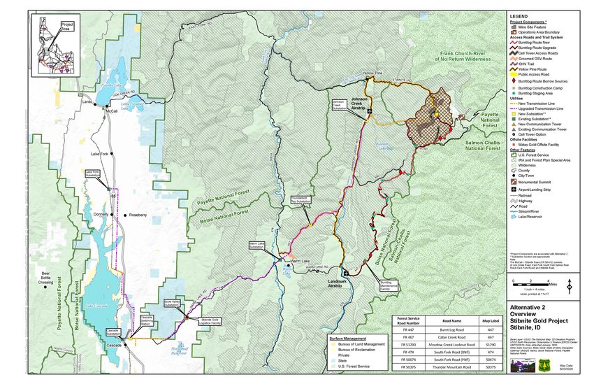
This page intentionally left blank
LJSDA United States
      Department of
                              Forest
                              Service
                                           Payette National Forest                   500 North Mission Street
                                                                                     McCall, ID 83638
7?:::77775
iiillllll    Agriculture                                                             208-634-0700

                                                               File Code:       1950;2810
                                                                    Date:       August 5, 2020

         Dear Interested Party:

         The Forest Service is seeking public comments on the Draft Environmental Impact Statement (DEIS) for
         the proposed Stibnite Gold Project (SGP). This document was prepared in accordance with the National
         Environmental Policy Act of1969, as amended; the National Forest Management Act of1976 (NFMA),
         36 CFR 218; and all other applicable law, regulation, and policy. The DEIS considers approval ofa plan
         ofoperations for mining, either as submitted by Midas Gold Idaho, Inc. or as reasonably modified to
         protect National Forest System (NFS) resources.

         The proposed project is located on NFS lands that are open to mineral entty on the Payette National
         Forest (PNF) and Boise National Forest (BNF) on the Krassel and Cascade Ranger Districts, respectively.
         Components ofthe proposed project include the following: three open mine pits; ore processing facilities;
         development rock storage facilities; a tailings storage facility; a water treatment facility; access and haul
         roads; electrical transmission lines; and various other support facilities. The potentially affected area for
         the proposed project includes approximately 3,500 acres on federal, state, and private lands located in
         Valley County, Idaho.
         Some ofthe proposed mining operations would be inconsistent with applicable PNF and BNF Forest Plan
         standards; therefore, project-specific amendments to the PNF and BNF Land and Resource Management
         Plans (LRMPs) would be required. The Notice oflntent (NOi) to prepare an EIS that was published on
         June 5, 2017 (82 FR 25759) indicated the possible need for plan amendments to address inconsistencies
         with Forest Plan standards, but the amendments that would be needed were not identified at that time. The
         proposed plan amendments are expected to be approved in the decision document for the Stibnite Gold
         Project and these plan amendments only apply to this project (36 CFR 219.14 paragraphs (a) and (c)). The
         details ofthe proposed amendments and which requirements of 36 CFR §§ 219.8 through 219.11 are
         likely to be directly related to the amendments, can be found in Appendix A ofthe DEIS.
         The Environmental Protection Agency (EPA) published a Notice ofAvailability (NOA) for the DEIS in
         the Federal Register on August 14, 2020. ConcutTent with the NOA ofthe DEIS publication in the
         Federal Register, a legal notice was published in the PNF and BNF newspaper ofrecord, The Idaho
         Statesman on August 14, 2020 and a courtesy copy ofthe legal notice will also be provided to the McCall
         Star-News for publication on August 13, 2020. The legal notice serves as the public notification of
         info1mation for the proposed plan amendments, as required in the 2012 planning rule (36 CFR
         219.13(6)(2) and 36 CFR 219.16(a)(2)).
         The Forest Service encourages the public to review and provide c01mnents on the DEIS; comments
         received during the public comment period will be considered in the preparation ofthe Final
         Environmental Impact Statement (FEIS). The legally required comment period for a DEIS and for
         project-specific Forest Plan amendments is 45 days following the date ofpublication ofthe NOA and the
         legal notice, respectively. As the responsible official, I have decided to extend the comment period by 15
         days leading to a total of60 days following publication ofthe NOA and legal notice, given the level of
         documentation associated with this project. Mailed or electronic comments will be accepted; however,
         electronic submission ofcomments is encouraged. Mailed comments must be submitted to me at the

                                                                                                                                   ft.
                                           Caring for the Land and Serving People                      Printed on Recycled Paper   "'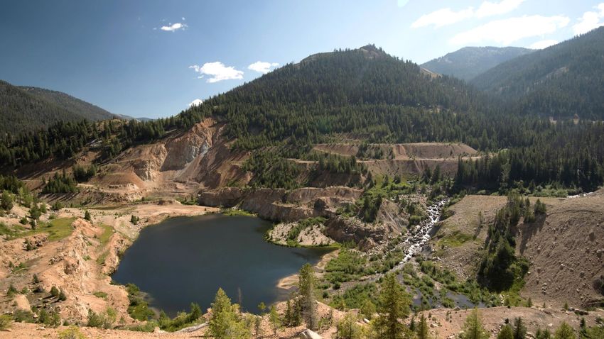
2

following address: Linda Jackson, Payette Forest Supervisor, 500 N. Mission Street, Building 2 McCall,
Idaho 83638-3805. Please be advised that our offices are minimally staffed in response to Coronavirus
(COVID-19) and hand-delivered comments are not being accepted at this time. Electronic comments must
be submitted in a common digital format such as plain text (.txt), rich text fonnat (.rtf), Word (.doc,
.docx) or PDF (.pdf) to https://cara.ecosystem-management.org/Public/Commentlnput?Project=50516.
All comments, including names and addresses when provided, are placed in the record and are available
for public inspection and copying. The public may inspect comments received online via the public
reading room at: https://cara.ecosystem-management.org/Public/ReadingRoom?project=50516.
The decision to approve the proposed project will be subject to the objection process identified in 36 CFR
part 218 Subpatis A and B. Only those who submit timely and specific written comments, as defined in
§218.2, regarding the proposed project and project-specific plan amendments during a public comment
period established by the responsible official are eligible to file an objection per §218.5. It is the
responsibility of all individuals and organizations to ensure that their comments are received in a timely
manner. For objection eligibility, each individual or representative from each entity submitting timely and
specific written comments must either sign the comments or verify identity upon request per
§218.24(b)(8). As provided by 36 CFR 219.59(b), the administrative review process of 36 CFR 218 also
applies to the project-specific plan amendments.
The DEIS, NOA, legal notice and other project information is available on the project webpage at:
https://www.fs.usda.gov/project/?project=505l 6. The project webpage provides you with tools to engage
in the public comment process.

Virtual Open House Meeting
Due to current health precautions associated with COVID-19, the Forest Service is providing alternative
measures for conducting public engagement. A Vitiual Public Meeting Room using the open house
format has been designed to conduct public engagement and solicit feedback on the Stibnite Gold Project
DEIS. The Virtual Public Meeting Room will be available on August 24, 2020 at:
https://www.fs.usda.gov/project/?project=50516&exp=meetingnoticeinfo and will remain open through
the public comment period. Instructions for entry to the Virtual Public Meeting Room will be included in
the link. Thank you for your understanding as we adopt these new measures during this titne to comply
with the current guidelines and slow the spread of COVID-19 in our community.
For additional information please contact Brian Harris, Payette National Forest Public Affairs Officer at
(208) 634-6945 or brian.d.harris@usda.gov. Individuals who use telecommunication devices for the deaf
(TDD) may call the Federal Information Relay Service (FIRS) at 1-800-877-8339 between 8:00 a.m. and
8:00 p.m., Eastern Titne, Monday through Friday.

Sincerely,

LINDA L JACKSON
Forest Supervisor
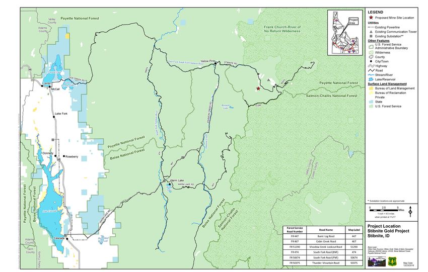
EXECUTIVE SUMMARY

ES 1.0 INTRODUCTION
The United States Department of Agriculture Forest Service (Forest Service), has prepared this
Draft Environmental Impact Statement (EIS) for the proposed Stibnite Gold Project (SGP). The
SGP proposes mining operations, including an open pit hard rock mine and associated
processing facilities, located within Valley County in central Idaho on federal, state, and private
lands (Figure ES1-1). The SGP would produce gold and silver doré, and antimony concentrate,
for commercial sale by Midas Gold Idaho, Inc. (Midas Gold).

This Draft EIS has been prepared using an interdisciplinary approach pursuant to the National
Environmental Policy Act (NEPA) in order to identify and analyze the probable environmental
impacts from a reasonable range of action alternatives (including the proposed action), and the
no action alternative. The Draft EIS affords interested parties and the public the opportunity to
become informed and to comment. When finalized, the EIS will inform the federal decisions
required for the SGP.

Under the authority of the Payette Forest Supervisor, the Forest Service is the lead agency for
purposes of the SGP NEPA process and preparation of this Draft EIS. In addition, there are six
cooperating agencies with jurisdiction over some aspect of the project by law or special
expertise with respect to environmental effects that are addressed in the Draft EIS: U.S. Army
Corps of Engineers (USACE); U.S. Environmental Protection Agency; Idaho Department of
Lands; Idaho Department of Environmental Quality; Idaho Governor’s Office of Energy and
Mineral Resources; and Valley County, Idaho.

The Draft EIS and supporting documents are available on the project website at:
https://www.fs.usda.gov/project/?project=50516.

ES 2.0 PROJECT OVERVIEW
The SGP Plan of Restoration and Operations submitted in September 2016 (Midas Gold 2016)
(hereinafter referred to as plan of operations), and subsequent additional information and
clarifications, serve as the baseline project description for the impact analysis in this Draft EIS.
A detailed description of the SGP, based upon the plan of operations, is provided in Chapter 2
of the Draft EIS.

The SGP consists of a mine site and processing facilities, associated access roads, and off-site
facilities located in Valley County, in central Idaho (Figure ES1-1). The mine site is located in
the East Fork South Fork Salmon River (EFSFSR) drainage basin. The SGP area is a complex

Stibnite Gold Project Draft Environmental Impact Statement                                      ES-1
EXECUTIVE SUMMARY

blend of both remote wilderness lands with high recreational values and potential wilderness
characteristics, and areas impacted by historical gold, silver, antimony, and tungsten mining,
processing, and resulting legacy contamination. The potentially affected area, encompassing
approximately 3,500 acres, is described in detail in Chapter 3 of the Draft EIS.

Midas Gold’s plan of operations to conduct mining operations that produce gold and silver doré,
and antimony concentrates, includes open pits, ore transportation equipment, ore processing
facilities, development rock storage facilities, a tailing storage facility, a water treatment facility,
road construction, electrical transmission lines, and various other facilities needed to support
mining activities. The plan of operations incorporates closure and reclamation activities, and
mitigation that may avoid, minimize, or compensate for adverse environmental effects caused
by the SGP, and also incorporates actions that mitigate legacy contamination at locations within
the mine site. Under the plan of operations, construction, operation, closure and reclamation
phases of the SGP would take place over a period of approximately 20 years, not including the
period of time required for long-term monitoring and maintenance. Environmental monitoring
and maintenance would continue for as long as needed to demonstrate that the site has been
fully reclaimed.

ES 3.0 CONNECTED ACTIONS
The SGP would require upgrades and new construction to electric infrastructure outside of the
mine site and subject to different approvals. Changes to electric infrastructure include:

    •   Construction of two new substations (Scott Valley and Thunderbolt Tap) as well as a
        new switching substation near Cascade (Cascade switching station). The existing Scott
        Valley substation would be removed.
    •   Switching power to the village of Yellow Pine to come from the Johnson Creek
        substation instead of the Warm Lake substation.
    •   Upgrading approximately 64 miles of the existing 12.5-kilovolt and 69-kilovolt
        transmission lines between the Lake Fork and Johnson Creek substations to
        138-kilovolt service. The right-of-way corridor would be 50 to 100 feet and existing
        structures would be replaced with taller structures along the existing right-of-way.
    •   Upgrading the substations located at Oxbow Dam, Horse Flat, McCall, Lake Fork, and
        Warm Lake.

Upgrades of the transmission line and access roads would require the Forest Service and the
U.S. Bureau of Reclamation to amend existing Idaho Power Company special use permits and
portions would cross Idaho State Trust Land and would require approval of the Idaho
Department of Lands.

Stibnite Gold Project Draft Environmental Impact Statement                                         ES-2
EXECUTIVE SUMMARY Figure Source: AECOM 2020 Figure ES1-1 Project Location Stibnite Gold Project Draft Environmental Impact Statement ES-3
EXECUTIVE SUMMARY

                                                             This page intentionally left blank

Stibnite Gold Project Draft Environmental Impact Statement                                        ES-4
EXECUTIVE SUMMARY
ES 3.0 PURPOSE AND NEED
The purpose and need statement is an important element of the NEPA process that is used to
identify and screen action alternatives. For this Draft EIS, the SGP plan of operations serves as
the basis for determining purpose and need. Accordingly, the other action alternatives analyzed
in the Draft EIS were developed based upon the plan of operations.
ES 3.1 Forest Service Purpose and Need
The Forest Service’s purpose is to consider approval of the SGP plan of operations submitted
by Midas Gold in September 2016, as supplemented, to mine and process gold, silver and
antimony from deposits at the mine site in central Idaho for commercial sale.
The need for this action is to:
• Respond to Midas Gold’s plan for development of the SGP to mine gold, silver, and
antimony deposits in central Idaho;
• Ensure that the selected alternative, where feasible, would minimize adverse
environmental impacts on National Forest System (NFS) surface resources;
• Ensure that, prior to approval, measures are included that provide for mitigation of
environmental impacts and reclamation of the NFS surface disturbance;
• Ensure that the selected alternative would comply with other applicable federal and state
laws and regulations.
The Forest Service purpose and need for action are established by the agency’s responsibilities
under the Organic Administration Act of 1897 (16 United States Code 478, 482, and 551) and
the locatable minerals regulations at 36 Code of Federal Regulations (CFR) 228, subpart A,
which set forth rules and procedures through which use of the surface of NFS lands in
connection with operations authorized by the United States Mining Laws (30 United States
Code 21-54), which confer a statutory right to enter upon the public lands to search for minerals,
shall be conducted so as to minimize adverse environmental impacts on NFS surface
resources.
ES 3.2 USACE Purpose and Need
The SGP plan of operations includes the discharge of dredge or fill material into waters of the
United States (WOTUS), including wetlands. Accordingly, the USACE will be reviewing the
proposed SGP utilizing this NEPA process to support a permit decision pursuant to Section 404
of the Clean Water Act (CWA) to either issue, issue with special condition, or deny a permit for
the project. As a part of its review, the USACE is required by the CWA to independently
consider and identify the activity’s underlying purpose and need from the perspective of Midas
Gold, as the applicant, and the perspective of the public. The USACE has determined that the
overall purpose of the SGP is to mine gold, silver, and antimony from ore deposits associates
with the mining claims and rights of Midas Gold in Valley County, Idaho. The USACE has
Stibnite Gold Project Draft Environmental Impact Statement ES-5EXECUTIVE SUMMARY determined that the overall purpose of the SGP is to mine gold, silver, and antimony from ore deposits associated with the mining claims and rights of Midas Gold in Valley County, Idaho. USACE also has determined that the basic purpose is not “water dependent” as this term is defined for purposes of Section 404 of the CWA. ES 4.0 FEDERAL DECISION FRAMEWORK This NEPA process is to inform the federal decisions required for Midas Gold to proceed with the SGP. The leading federal decisions applicable to the SGP will be made by the Forest Service and the USACE. Midas Gold also must apply for and receive other federal, state, and local permits, which are identified in Table 1.5-1 and in the plan of operations. ES 4.1 Forest Service Decisions As the responsible official acting on behalf of the Forest Service, the Payette Forest Supervisor will determine whether to approve the plan of operations for the SGP as submitted and supplemented, or whether to approve a modified plan based on all or portions of the other action alternatives considered in detail in the Final EIS, including mitigation. In making this decision, the Payette Forest Supervisor has discretion to determine whether the changes in the proposed plan of operations will be required prior to approval in order to meet the requirements of 36 CFR 228, subpart A, and other laws and regulations applicable to operations on NFS lands. In addition, proposed project-specific amendments to the Payette National Forest Land and Resource Management Plan (Forest Plan) (Forest Service 2003) and the Boise National Forest Land and Resource Management Plan (Forest Service 2010), as described in Appendix A, have been analyzed in this Draft EIS. The Payette Forest Supervisor will determine whether to amend portions of the Payette National Forest Land and Resource Management Plan (Forest Service 2003), and the Boise Forest Supervisor will determine whether to amend portions of the Boise National Forest Land and Resource Management Plan as amended (Forest Service 2010), with respect to the SGP. These project-specific amendments would be one-time adjustments made according to the 2012 Planning Rule (36 CFR Part 219.13). Finally, SGP activities identified in the plan of operations would impact Meadow Creek Lookout Road within the Salmon-Challis National Forest. This road, in the area that would be impacted, is administered by the Payette National Forest (PNF) under the Challis National Forest Land and Resource Management Plan (Forest Service 1987). Accordingly, the Payette Forest Supervisor will determine whether the activities in this area are consistent with applicable standards and guides. ES 4.2 USACE Decisions The USACE regulates the discharge of dredged and/or fill material into WOTUS, including wetlands, pursuant to Section 404 of the CWA. Because the SGP plan of operations includes the discharge of dredged and/or fill material into WOTUS, Midas Gold must obtain a Department of Army permit (33 CFR 323) in order to proceed with the SGP. USACE w will evaluate the SGP Stibnite Gold Project Draft Environmental Impact Statement ES-6
EXECUTIVE SUMMARY

based upon the requirements of Section 404 of the CWA, including the Section 404(b)(1)
Guidelines (40 CFR 230).

ES 5.0 PUBLIC AND TRIBAL ENGAGEMENT
The Forest Service published a Notice of Intent to prepare an EIS for the SGP in the Federal
Register on June 5, 2017. The Notice of Intent initiated a 45-day scoping period that ended on
July 20, 2017. During this time period, the Forest Service conducted five public meetings,
including meetings in Cascade, McCall, Yellow Pine, and two in Boise, Idaho. In addition, legal
notices were published June 2017 in The Idaho Statesman, Boise, Idaho (the newspaper of
record) and The Star News, McCall, Idaho.

The Forest Service conducted government-to-government consultation regarding the SGP with
three federally-recognized tribes: the Nez Perce Tribe; the Shoshone-Bannock Tribes; and the
Shoshone-Paiute Tribes. This consultation was initiated with the Tribes through a notification
letter from the Forest Service offering opportunities to participate in formal consultation, to
participate in the NEPA process as cooperating agencies, or to routinely receive information
about the SGP and the NEPA process. Details of the consultation process are included in
Section 5.1.2, Tribal Consultation and Government-to-Government Consultation.

ES 6.0 SIGNIFICANT ISSUES
The Forest Service, in coordination with the cooperating agencies, and informed by the NEPA
scoping process, tribal consultation, and public comment, has identified eight significant issues.
These significant issues have been used to develop alternatives to the proposed action and
mitigation measures. The following are the significant issues identified for the SGP:

   •   Surface Water and Groundwater – Construction and operation of mine infrastructure
       may impact water quality and quantity.
   •   Sensitive Plant Species – Construction and operation of mine infrastructure may impact
       habitat for sensitive plant species.
   •   Wetlands and Riparian Areas – Construction and operation of mine infrastructure may
       affect quantity of wetland (e.g., acres), impact ecological function, and fragment wetland
       habitat.
   •   Federally Listed Fish Species – Construction and operation of mine infrastructure may
       impact habitat for steelhead, salmon, and bull trout.
   •   Traffic – Construction, operation, and reclamation may affect traffic volumes, types of
       vehicles, and patterns of use.
   •   Public and Tribal Access – Construction and operation of mine infrastructure may impact
       public access to NFS lands, travel routes, and access to reserved tribal rights.

Stibnite Gold Project Draft Environmental Impact Statement                                    ES-7
EXECUTIVE SUMMARY
• Visual Quality – Construction and operation of mine infrastructure may impact scenic
integrity and quality, and may result in change of the Forest Plan(s) Visual Quality
Objectives.
• Idaho Inventoried Roadless Areas – Construction and operation of mine infrastructure in
inventoried roadless areas may affect biophysical and social values of IRAs.
Chapters 3 and 4 of this Draft EIS also address additional resources and resource-use related
issues that, while not identified as “significant,” remain relevant physical, biological, and social
impact considerations for discussion, analysis, and possible mitigation.
ES 7.0 ALTERNATIVES
NEPA requires consideration of a reasonable range of alternatives that can accomplish the
purpose of and need for the proposed action. Consideration of alternatives also is pertinent to
the USACE’s CWA 404(b)(1) assessment, which requires an analysis of practicable alternatives
to the proposed discharge into WOTUS. As used in this EIS, an action “alternative” is a
complete package of operations, activities, and facilities that comprise a functioning mine
project. A complete mining plan has several “component” parts, each necessary to allow
production. In many instances, operational components may be further comprised of
“subcomponents.” The Forest Service and the cooperating agencies, informed by the NEPA
scoping process, screened potential alternatives and component/subcomponent options based
upon four criteria:
1. Does the alternative, including a combination of component options, meet the purpose
and need of the project?
2. Could the alternative or component option potentially reduce environmental effects to at
least one resource?
3. Is the alternative or component option technically feasible?
4. Is the alternative or component option economically feasible?
This iterative process lead to selection of three action alternatives in addition to the plan of
operations submitted by Midas Gold. These four action alternatives, along with the no action
alternative, are fully described in Chapter 2 and summarized in Table 2.2-1. Detailed analysis is
included in Chapter 4 of this Draft EIS. Alternatives that were considered but eliminated from
further study also are addressed in Section 2.8, Alternatives Considered, Carried Forward, or
Eliminated From Further Study.
ES 7.1 ALTERNATIVE 1
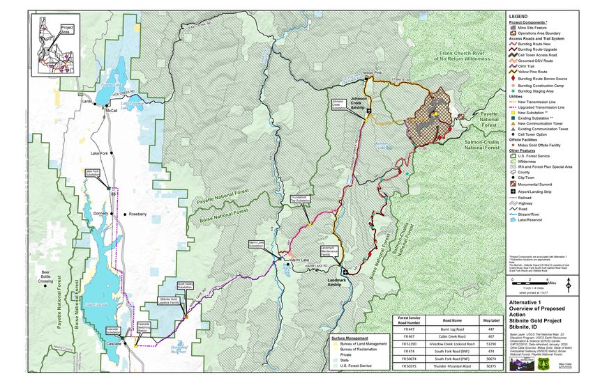
Alternative 1 is based on Midas Gold’s plan of operations and subsequent information and
clarifications as briefly described in Section ES 2.0, Project Overview. Operations would occur
on patented mining claims and other areas of federal public lands comprised of NFS lands that
Stibnite Gold Project Draft Environmental Impact Statement ES-8EXECUTIVE SUMMARY are administered by the PNF. Supporting infrastructure corridors (access and transmission) are located in the Boise National Forest and non-federal lands. Development of the mineral resources would include construction of access and haul roads within the mine site; construction of supporting infrastructure for the mine site; 3 open pits; ore processing; placement of tailings in a tailings storage facility (TSF) in the upper Meadow Creek valley; and placement of development rock in 4 development rock storage facilities (DRSFs). New access to the mine site would be provided by the proposed Burntlog Route. Electric power for the mine site and supporting infrastructure and facilities would be provided by constructing a new transmission line from the new Johnson Creek substation to the mine site. A logistics facility and a maintenance facility would be constructed along the access corridor. Alternative 1 serves as an important baseline project description for impact analysis because the other action alternatives were developed in response to the proposed plan of operations. Figure ES2-1 shows the main features of Alternative 1. Table ES2-1 provides a summary of the land management and acreage for the four major components of Alternative 1: mine site, access roads, utilities, and off-site facilities. Stibnite Gold Project Draft Environmental Impact Statement ES-9
EXECUTIVE SUMMARY

                                   This page intentionally left blank

Stibnite Gold Project Draft Environmental Impact Statement              ES-10
EXECUTIVE SUMMARY Figure Source: AECOM 2020 Figure ES2-1 Alternative 1 Overview of Proposed Action Stibnite Gold Project Draft Environmental Impact Statement ES-11
EXECUTIVE SUMMARY

                                                             This page intentionally left blank

Stibnite Gold Project Draft Environmental Impact Statement                                        ES-12
EXECUTIVE SUMMARY
Table ES2-1 Land Management and Acreage by Major Components for Alternative 1
Boise
Component National Bureau of Total
Private State PNF
Subtotal Forest Reclamation Acres
(BNF)
Mine Site Subtotal 557 0 0 1,4134 0 1,970
Existing Access 10 0 162 28 0 200
Roads Subtotal1
New Access Roads 0 0 233 112 0 345
Subtotal
Utilities Subtotal2 288 62 523 92 25 990
Offsite Facilities 25 0 3 0 0 28
Subtotal
Total3 880 62 921 1,6455 25 3,533
Table Source: AECOM 2020
Table Notes:
1 Existing access roads with minor to major improvements would be used for the SGP. Existing access roads
acreages reflect the current road configurations. Any additional disturbance to widen existing roads is included in
the new access roads subtotal.
2 Utilities affected acres include both existing utility corridors and access routes, and new utility corridors and access
routes. Some existing utility access routes would be upgraded. Utilities affected acres include upgrades to utilities
that are part of the Connected Actions.
3 Subtotals may not add to totals due to rounding.
4 Approximately 65 affected acres associated with surface exploration pads and temporary roads (mine site
component) have unknown land ownership because the exact locations of these exploration areas are not yet
known. The surface exploration acres are included in the PNF mine site subtotal.
5 Approximately 5 acres of land listed under the PNF is administered by the PNF but is within the boundary of the
Salmon Challis National Forest.
ES 7.2 ALTERNATIVE 2
Alternative 2 represents a modified version of Alternative 1, primarily developed by Midas Gold,
to provide additional avoidance and mitigation measures to address potential impact issues
(Brown and Caldwell 2019). Although Alternative 2 is, in practical effect, the proposed action for
which Midas Gold is now seeking federal approval, Midas Gold has not submitted a revised plan
of operations with all the components of Alternative 1, but premised upon this Alternative 2.
Accordingly, the description of Alternative 2 remains a derivative of Alternative 1 as detailed in
the original plan of operations (Midas Gold 2016).
Development of the mineral resources would include construction of access and haul roads
within the mine site; construction of supporting infrastructure for the mine site; 3 open pits; ore
processing; placement of tailings in a TSF in upper Meadow Creek valley; and placement of
development rock in 3 DRSFs. New access to the mine site would be provided by the proposed
Burntlog Route. Public access would be provided through the mine site using one of two
Stibnite Gold Project Draft Environmental Impact Statement ES-13EXECUTIVE SUMMARY
proposed options. Electric power for the mine site and supporting infrastructure and facilities
would be provided by constructing a new transmission line from the new Johnson Creek
substation to the mine site. Two additional offsite support facilities would be constructed along
access corridors.
Figure ES2-2 shows the main components under Alternative 2 and Table ES2-2 provides a
summary of the land management and acreage for the four major components: mine site,
access road, utilities and off-site facilities.
Table ES2-2 Land Management and Acreage by Major Components for Alternative 2
Bureau of Total
Area Subtotal Private State BNF PNF
Reclamation Acres
Mine Site Subtotal 554 0 0 1,3254 0 1,879
Existing Access Roads 10 0 162 28 0 200
Subtotal1
New Access Roads 0 232 97 0 329
Subtotal
Utilities Subtotal2 265 76 532 92 19 985
Offsite Facilities Subtotal 25 0 5 0 0 30
Total3 854 76 931 1,5425 19 3,423
Table Notes:
1 Existing access roads with minor to major improvements would be used for the SGP. Existing access roads
acreages reflect the current road configurations. Any additional disturbance to widen existing roads is included in
the new access roads subtotal.
2 Utilities affected acres include both existing utility corridors and access routes, and new utility corridors and access
routes. Some existing utility access routes would be upgraded. Utilities affected acres include upgrades to utilities
that are part of the Connected Actions.
3 Subtotals may not add to totals due to rounding.
4 Approximately 65 affected acres associated with surface exploration pads and temporary roads (mine site
component) have unknown land ownership because the exact locations of these exploration areas are not yet
known. The surface exploration acres are included in the PNF mine site subtotal.
5 Approximately 5 acres of land listed under the PNF is administered by the PNF but is within the boundary of the
Salmon-Challis National Forest.
Stibnite Gold Project Draft Environmental Impact Statement ES-14EXECUTIVE SUMMARY Figure Source: AECOM 2020 Figure ES2-2 Alternative 2 Overview Stibnite Gold Project Draft Environmental Impact Statement ES-15
EXECUTIVE SUMMARY

                                                             This page intentionally left blank

Stibnite Gold Project Draft Environmental Impact Statement                                        ES-16
EXECUTIVE SUMMARY
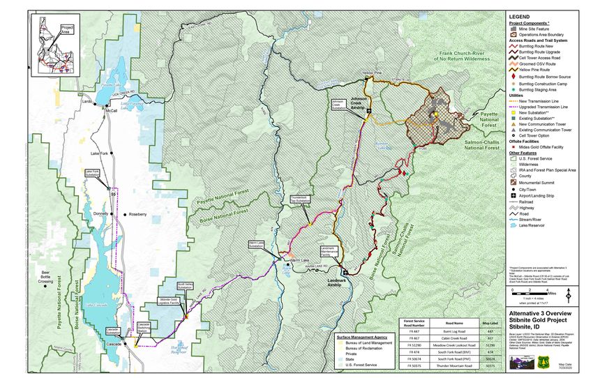
ES 7.3 ALT ERNAT IVE 3
Alternative 3 was developed to evaluate the extent to which an alternative location for the TSF
and a DRSF would avoid or reduce potential adverse impacts, primarily to WOTUS and
federally-listed fish species. Under Alternative 3, the TSF and a DRSF would be located in the
upper EFSFSR valley. Surface water management, access roads, and mine site facilities would
be changed to accommodate relocation of the TSF and DRSF.
Figure ES2-3 shows the main components of Alternative 3. Table ES2-3 provides a summary
of the land management and acreage for the four major components: mine site, access road,
utilities and off-site facilities.
Table ES2-3 Land Management and Acreage by Major Components for Alternative 3
Bureau of
Area Subtotal Private State BNF PNF Total Acres
Reclamation
Mine Site Subtotal 511 0 0 1,5604 0 2,071
Existing Access 10 0 162 39 0 211
Roads Subtotal1
New Access Roads 0 0 246 63 0 310
Subtotal
Utilities Subtotal2 287 62 524 92 25 990
Offsite Facilities 25 0 3 0 0 28
Subtotal
Total3 833 62 935 1,7545 25 3,610
Table Notes:
1 Existing access roads with minor to major improvements would be used for the SGP. Existing access roads
acreages reflect the current road configurations. Any additional disturbance to widen existing roads is included in
the new access roads subtotal.
2 Utilities affected acres include both existing utility corridors and access routes, and new utility corridors and access
routes. Some existing utility access routes would be upgraded. Utilities affected acres include upgrades to utilities
that are part of the Connected Actions.
3 Subtotals may not add to totals due to rounding.
4 Approximately 65 affected acres associated with surface exploration pads and temporary roads (mine site
component) have unknown land ownership because the exact locations of these exploration areas are not yet
known. The surface exploration acres are included in the PNF mine site subtotal.
5 Approximately 19 acres of land listed under the PNF is administered by the PNF but is within the boundary of the
Salmon Challis National Forest.
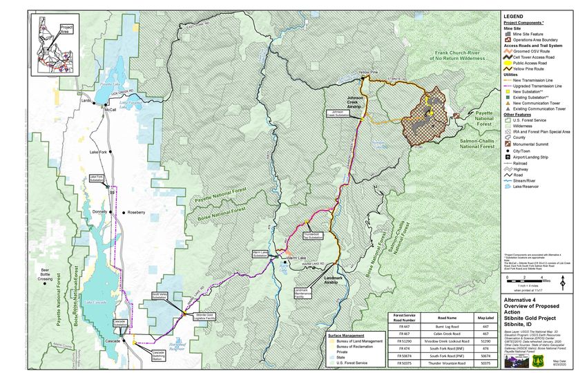
ES 7.4 ALTERNATIVE 4
Alternative 4 incorporates several independent component options developed by the Forest
Service and the cooperating agencies to evaluate the potential to reduce adverse effects
concerning many of the significant issues identified during scoping. The primary focus of
Stibnite Gold Project Draft Environmental Impact Statement ES-17EXECUTIVE SUMMARY
Alternative 4 is consideration of using an existing route for mine access (the Yellow Pine Route)
instead of the Burntlog Route identified under Alternative 1. The Burntlog Route which would
require approximately 17 miles of new road construction, including approximately 14 miles of
new construction in inventoried roadless areas. The Yellow Pine Route would include public
access through the mine site. Other modifications to mine site facilities and off-site facilities are
proposed in Alternative 4.
Figure ES2-4 shows the main components of Alternative 4. Table ES2-4 provides a summary
of the land management and acreage for the four major components: mine site, access road,
utilities and off-site facilities.
Table ES2-4 Land Management and Acreage by Major Components for Alternative 4
Bureau of
Area Subtotal Private State BNF PNF Total Acres
Reclamation
Mine Site Subtotal 560 0 0 1,4294 0 1,989
Existing Access 11 0 91 21 0 123
Roads Subtotal1
New Access Roads 0 0 77 17 0 94
Subtotal
Utilities Subtotal2 288 64 522 86 25 984
Offsite Facilities 25 0 4 0 0 29
Subtotal
Total3 885 62 694 1,5535 25 3,219
Table Notes:
1 Existing access roads with minor to major improvements would be used for the SGP. Existing access roads
acreages reflect the current road configurations. Any additional disturbance to widen existing roads is included in
the new access roads subtotal.
2 Utilities affected acres include both existing utility corridors and access routes, and new utility corridors and access
routes. Some existing utility access routes would be upgraded. Utilities affected acres include upgrades to utilities
that are part of the Connected Actions.
3 Subtotals may not add to totals due to rounding.
4 Approximately 65 affected acres associated with surface exploration pads and temporary roads (mine site
component) have unknown land ownership because the exact locations of these exploration areas are not yet
known. The surface exploration acres are included in the PNF mine site subtotal.
5 Approximately 14 acres of land listed under the PNF is administered by the PNF but is within the boundary of the
Salmon Challis National Forest.
Stibnite Gold Project Draft Environmental Impact Statement ES-18EXECUTIVE SUMMARY Figure Source: AECOM 2020 Figure ES2-3 Alternative 3 Overview Stibnite Gold Project Draft Environmental Impact Statement ES-19
EXECUTIVE SUMMARY

Figure Source: AECOM 2020

Figure ES2-4 Alternative 4 Overview of Proposed Action

Stibnite Gold Project Draft Environmental Impact Statement   ES-20
EXECUTIVE SUMMARY

ES 7.5 ALTERNATIVE 5
Alternative 5 is the No Action Alternative, which provides an environmental baseline for
comparison of the action alternatives. Under the No Action Alternative, the mining, ore
processing, and related activities under the action alternatives considered in this Draft EIS
would not take place. However, existing and approved activities (i.e., approved exploration
activities and associated reclamation obligations) would continue and Midas Gold would not be
precluded from subsequently submitting another plan of operations pursuant to the General
Mining Law of 1872.

ES 8.0 ENVIRONMENTAL CONSEQUENCES
Table ES4-1 provides a summary and comparison of the potential environmental impacts of the
four action alternatives considered in detail and the No Action Alternative for the eight significant
issues identified in Section ES 6.0 above. Detailed descriptions of potential impacts are
presented in Chapter 4, Environmental Consequences.

Stibnite Gold Project Draft Environmental Impact Statement                                     ES-21
EXECUTIVE SUMMARY

                                   This page intentionally left blank

Stibnite Gold Project Draft Environmental Impact Statement              ES-22
EXECUTIVE SUMMARY
Table ES4-1 Summary and Comparison of the Potential Environmental Impacts Associated with the Significant Issues by Alternative
Issue Indicator Baseline Conditions Alternative 1 Alternative 2 Alternative 3 Alternative 4 Alternative 5
Surface Water and Groundwater Quantity
The SGP may cause Stream flow characteristics (daily, Surface waters include: the Meadow Creek monthly Stream flow impacts partially Stream flow would be impacted Stream flow would be impacted Alternative 5 would result in no
changes in quantity of seasonal, annual). EFSFSR, Rabbit Creek, average low flow during mitigated for Meadow Creek in by Alternative 3 within the by Alternative 4 within the changes to existing stream flow
surface water and Meadow Creek, East Fork operations = 2.3 cfs (15% the vicinity of the Hangar Flats analysis area. Simulated flows analysis area. Simulated flows characteristics.
groundwater in all Meadow Creek (also known as reduction from baseline pit and pit lake relative to are similar to Alternative 1. are similar to Alternative 1.
drainages within the Blowout Creek), Garnet Creek, conditions). Alternative 1.
analysis area. Fiddle Creek, Midnight Creek, The primary predicted impact: Predicted stream low flows for
Hennessy Creek, West End reduction in streamflow along Alternative 2 two times higher
Creek, and Sugar Creek. Meadow Creek near the Hangar than the low flows under
Monthly average seasonal low Flats pit and pit lake close to the Alternative 1 during mine years
flows: end of the mine operation and 7 through 12.
Meadow Creek between TSF early post closure. Across these years, the average
and Hangar Flats pit = 2.7 cfs. Simulated flows vary from no monthly flow reduction relative
Meadow Creek below the predicted change to a 45% to the existing conditions was
diversion and above EFSFSR reduction in low flows during the predicted to be 32% for
(mine years 7-10) = 3.8 cfs. mine operational period. Flows Alternative 2 and 47% for
vary from no predicted change Alternative 1. In early post
to a 100% reduction during the closure when the section of
early post- closure period. Meadow Creek is predicted to
In most areas, groundwater in go dry under Alternative 1,
the alluvial aquifers recover predictions for Alternative 2 are
within 10 years after the a 26% reduction in the average
cessation of mining. Large monthly flow.
areas of the bedrock aquifer are Surface flows are generally
also expected to recover. predicted to recover to pre-mine
However, there is less conditions by approximately
confidence about overall long- mine year 15 (3 years after
term recovery of the bedrock operations cease).
aquifer.
.
The SGP may cause The extent, magnitude, and Groundwater flow in the analysis Dewatering of the pits lowers The extended liner reduces The TSF and Hangar Flats The extent, magnitude, and Alternative 5 would result in no
changes in quantity of duration of groundwater level area occurs primarily in the groundwater levels in the stream loss from Meadow DRSF constructed in the duration of groundwater level changes to existing (baseline)
surface water and changes. Quaternary unconsolidated alluvial and bedrock formations Creek near the Hangar Flats pit, EFSFSR valley would lower changes would be similar to groundwater flow conditions.
groundwater in all deposits filling the valleys and during the mining and post and reduces that pit’s groundwater levels within their Alternative 1.
drainages within the through the unconsolidated closure periods, and reduces dewatering rates by more than footprint. Hangar Flats pit
analysis area. deposits covering the flows in surface water streams 25%. Partial backfill of Hangar dewatering rates and the rate of
mountainsides. that receive groundwater Flats pit with West End water infiltrating via the RIBs
discharge. Development Rock and somewhat higher compared to
In most areas, groundwater in diversion of Meadow Creek high Alternative 1.
the alluvial aquifers recover flow to the pit lake reduces the Hangar Flats pit fills with water
within 10 years after the time of filling the pit with water somewhat quicker.
cessation of mining. Large from the Hangar Flats pit lake.
areas of the bedrock aquifer are
also expected to recover.
However, there is less
confidence about overall long-
term recovery of the bedrock
aquifer.
Development of DRSFs and
TSF within Meadow Creek
valley would result in lowering
water table levels by more than
ten feet in some areas within
their footprint, and in area close
Stibnite Gold Project Draft Environmental Impact Statement ES-23EXECUTIVE SUMMARY
Issue Indicator Baseline Conditions Alternative 1 Alternative 2 Alternative 3 Alternative 4 Alternative 5
around, during production and
post closure periods.
The SGP may affect water Change in water rights availability Four existing water rights at the No changes in water rights No changes in water rights No changes in water rights No changes in water rights No changes in water rights
rights. in the SGP area. mine site owned by Midas Gold. availability in the SGP area. availability in the SGP area. availability in the SGP area. availability in the SGP area. availability.
The SGP may affect water New water rights needed. Existing water rights held by An additional 2.39 cfs and 1,730 Same as Alternative 1. Same as Alternative 1. Same as Alternative 1. No new water rights required.
rights. Midas Gold: acre-feet of groundwater rights
77-7285 - Groundwater right for needed to support ore
storage and mining with processing.
diversion of 0.5 cfs for a An additional 0.34 cfs and
maximum total usage of 39.2 10 acre-feet of groundwater
acre-feet. rights needed for potable water
77-7141 – Groundwater right for supply.
domestic with diversion of 0.2 During drought conditions,
cfs for a maximum total usage of temporary seasonal withdrawal
11.4 acre-feet. of up to 5.63 cfs from
77-7293 – Surface water right for groundwater.
storage and mining for diversion An additional water right for 3.47
of 0.25 cfs and a maximum total cfs diversion of surface would
usage of 20 acre-feet. be needed.
77-7122 – Surface water right for
storage and mining for diversion
of 0.33 cfs for a maximum total
usage of 7.1 acre-feet.
Surface Water and Groundwater Quality
The SGP may affect soil Volume and disposition of No new mining waste Development Rock: Development Rock: Development Rock: Same as Alternative 1. No new mining waste
and water resources mineralized waste generated. generated. • TSF embankment (61 MT). • TSF embankment (61 MT). • TSF embankment (61 MT). generated.
through acid rock drainage
and/or metals leaching • Hangar Flats DRSF and TSF • Hangar Flats DRSF and TSF • EFSFSR DRSF and TSF
from mineralized rock in buttress (81 MT). buttress (81 MT). buttress (81 MT).
the mine pits, DRSFs, and • Fiddle DRSF (68 MT). • Fiddle DRSF (68 MT). • Fiddle DRSF (68 MT).
TSF. • West End DRSF (25 MT). • Yellow Pine Pit backfill (111 • West End DRSF (25 MT).
• Yellow Pine Pit backfill (111 MT). • Yellow Pine Pit backfill (111
MT). • Midnight Pit backfill (6 MT). MT).
Tailings: • Hangar Flats Pit partial Tailings:
• TSF (100 MT). backfill (18 MT). • EFSFSR TSF (100 MT).
• On-site lime generation (1
MT).
Tailings:
• TSF (100 MT).
The SGP may affect soil Lithologic composition of final pit No known mapped extent of Area of Potentially acid- Same as Alternative 1. Same as Alternative 1. Same as Alternative 1. Not applicable.
and water resources walls and exposure of potentially exposed lithologies in existing generating rock exposed in pit
through acid rock drainage acid-generating material. Yellow Pine and West End pits. walls:
and/or metals leaching • Hangar Flats Pit (37,076 m2,
from mineralized rock in 5.1% of total surface area).
the mine pits, DRSFs, and
TSF. • West End Pit.
(3,333 m2, 0.4%).
• Midnight Area
Pit (262 m2, 0.1%).
• Yellow Pine Pit (120,424 m2,
10.5%).
Stibnite Gold Project Draft Environmental Impact Statement ES-24EXECUTIVE SUMMARY
Issue Indicator Baseline Conditions Alternative 1 Alternative 2 Alternative 3 Alternative 4 Alternative 5
The SGP may affect soil Removal of legacy mine tailings Legacy waste in Meadow Creek SODA and Bradley tailings SODA and Bradley tailings No removal of SODA and SODA and Bradley tailings No removal of SODA and
and water resources and waste rock. valley from historical mining removed and repurposed. removed and repurposed. Bradley Tailings. removed and repurposed. Bradley Tailings.
through acid rock drainage Predicted leachate chemistry of operations, including SODA and Development Rock: Same as Alternative 1. Same as Alternative 1. Same as Alternative 1. Not applicable.
and/or metals leaching development rock and tailings. Bradley tailings.
from mineralized rock in • Generally non-acid
Not Applicable. generating but capable of
the mine pits, DRSFs, and
TSF. leaching arsenic, antimony,
aluminum, manganese, sulfate,
total dissolved solids, copper,
cadmium and zinc above water
quality criteria (Section
4.9.2.1.1.4).
Tailings:
• Anticipated tailings process
water chemistry and leachate
chemistry provided in Table
4.9-9.
The SGP may cause Surface water quality EFSFSR1: EFSFSR Post Closure1,2: EFSFSR Post Closure1,2: EFSFSR Post Closure1,2: EFSFSR Post Closure: Same as existing conditions.
changes in surface water parameters (e.g., pH, • Aluminum (0.010 to 0.016 • Aluminum (0.003 to 0.014 • Aluminum (0.007 to 0.018 • Aluminum (0.00047 to 0.020 • Same as Alternative 1
and groundwater quality. temperature, major ions, total mg/L). mg/L). mg/L). mg/L).
dissolved solids, metals, Access Roads:
sediment content, and organic • Antimony (0.012 to 0.031 • Antimony (0.009 to 0.026 • Antimony (0.009 to 0.026 • Antimony (0.017 to 0.033 • Mine access roads would
carbon). mg/L). mg/L). mg/L). mg/L). cross 50 different streams.
• Arsenic (0.025 to 0.063 • Arsenic (0.059 to 0.09 mg/L). • Arsenic (0.016 to 0.049 • Arsenic (0.083 to 0.13 • 6.5 miles (16 percent) of
mg/L). • Copper (0.00005 to 0.00268 mg/L). mg/L). mine operations access
• Copper (0.00023 to 0.00032 mg/L). • Copper (0.00005 to 0.00029 • Copper (0.000033 to 0.010 route within 100 feet of
mg/L). • Mercury (2.04E-4 to 3.9E-4 mg/L). mg/L). streams.
• Mercury (2.4E-6 to 5.7E-6 mg/L). • Mercury (5.9E-6 to 1.8E-5 • Mercury (7.7E-5 to 0.00014 • Sedimentation and fugitive
mg/L). • Summer Max Temperature mg/L). mg/L). dust similar in magnitude to
• Summer Max Temperature (13.9 to 22.3°C). • Summer Max Temperature • Summer Max Temperature Alternative 1, but would
(13.4 to 17.4°C). (13.9 to 21.7°C). (23 to 25.5°C). differ in location due to
Access Roads: exclusive use of YPR for
Access Roads: • Mine access roads would Access Roads: Access Roads: mine access.
• No mine-related traffic on cross 71 different streams. • Mine access roads would • Stream crossings same as Utilities:
existing Forest Service roads. • 1.69 miles (4 percent) of cross 69 different streams. Alternative 1.
• Same as Alternative 1
Utilities: mine operations access • 1.56 miles (4 percent) of • 1.24 miles (2.8 percent) of except for communication
• No power line upgrades or route w/in 100 feet of mine operations access mine operations access sites that would be
new lines constructed. streams. route within 100 feet of route within 100 feet of constructed/maintained
• Sedimentation and fugitive streams. streams. using helicopters, limiting
dust predicted to be within • Sedimentation and fugitive Utilities: the need for new access
the normal range of properly dust likely lower than • Same as Alternative 1. roads to these facilities.
maintained Forest Service Alternative 1 due to
roads. approximate 31 percent
Utilities: reduction in heavy vehicle
trips during mine operations.
• Mine utility work would cross
37 different streams. Utilities:
• Potential for transmission • Mine utility work would cross
line-related erosion and 36 different streams.
sedimentation would be • Potential for transmission
minimal. line-related erosion and
sedimentation would be
minimal.
Stibnite Gold Project Draft Environmental Impact Statement ES-25EXECUTIVE SUMMARY
Issue Indicator Baseline Conditions Alternative 1 Alternative 2 Alternative 3 Alternative 4 Alternative 5
The SGP may cause Groundwater quality parameters TSF1: TSF1: TSF: TSF1: Same as Alternative 1. Same as existing conditions.
changes in surface water (e.g., pH, major ions, total • pH (7.57). • pH (7.57). • Same as Alternative 1 • No change to existing
and groundwater quality. dissolved solids, metals). groundwater conditions in the
• Arsenic (0.006 mg/L). • Arsenic (0.007 mg/L). Hangar Flats DRSF1:
upper.
• Antimony (0.0020 mg/L). • Antimony (0.002 mg/L). • pH (6.76).
EFSFSR EFSFSR DRSF1:
• Mercury (5.6E-7 mg/L). • Mercury (1.8E-6 mg/L). • Arsenic (0.36 mg/L).
• pH (7.1).
Hangar Flats DRSF1: Hangar Flats DRSF1: • Iron (1.69 mg/L).
• Arsenic (0.089 mg/L).
• pH (6.90). • pH (6.75). • Manganese (2.39 mg/L).
• All other constituents below
• Arsenic (0.006 mg/L). • Arsenic (0.23 mg/L). West End DRSF: groundwater standards.
• Iron (2.63 mg/L). • Iron (1.75 to 2.01 mg/L). • Eliminated (same as existing West End DRSF:
• Manganese (2.63 mg/L). • Manganese (2.41 to 2.50 conditions).
• Same as Alternative 1.
West End DRSF1: mg/L). Fiddle DRSF1:
Fiddle DRSF:
• pH (8.15). West End DRSF1: • pH (7.37).
• Same as Alternative 1.
• Arsenic (0.30 mg/L). • pH (8.15). • Arsenic (0.02 mg/L).
Yellow Pine Pit Backfill:
• Arsenic (0.70 mg/L). Yellow Pine Pit Backfill1:
• Antimony (0.019 mg/L). • Same as Alternative 1.
• Antimony (0.13 mg/L). • Same as Alternative 1.
• Nitrate+nitrite (0.050 mg/L).
• Nitrate+nitrite (0.05 to 19.7 Midnight Area Pit Backfill1:
Fiddle DRSF1:
mg/L). • pH (8.7 to 8.9).
• pH (7.21).
Fiddle DRSF1: • Arsenic (2.2 mg/L).
• Arsenic (0.087 mg/L).
• pH (7.45). • Mercury (0.0042 mg/L).
Yellow Pine Pit Backfill1:
• Arsenic (0.015 mg/L). • Antimony (0.42 mg/L).
• pH (8.54).
Yellow Pine Pit Backfill1:
• Arsenic (0.32 mg/L).
• pH (8.6 to 8.9).
• Antimony (0.010 mg/L).
• Arsenic (2.12 mg/L).
• Mercury (3.8E-6 mg/L).
• Antimony (0.45 mg/L).
• Mercury (0.0034 mg/L).
The SGP may cause Predicted impact on Methylmercury not detected in Post closure Methylmercury No detectable change in Post closure Methylmercury Same as Alternative 1. Same as existing Conditions.
increased mercury methylmercury production. 90 percent of baseline stream concentrations up to 7.8 ng/L in Methylmercury with water concentrations up to 2.8 ng/L in
methylation in adjacent samples (EXECUTIVE SUMMARY
Issue Indicator Baseline Conditions Alternative 1 Alternative 2 Alternative 3 Alternative 4 Alternative 5
The SGP would remove Estimated number of mature Approximately 2,310 acres of An estimated 1,027 individual An estimated 997 individual An estimated 892 individual An estimated 613 individual None.
whitebark pine individuals, whitebark pine trees to be cut occupied whitebark pine habitat trees, 50 of which would be trees, 15 of which would be trees, 48 of which would be trees, 48 of which would be
and habitat conversion during SGP construction. were identified within the cone-bearing trees, would be mature, cone-bearing trees, mature, cone-bearing trees, mature, cone-bearing trees,
associated with the SGP analysis area. removed under Alternative 1. would be removed under would be removed under would be removed under
would impact seed This would be the largest Alternative 2. This would be the Alternative 3. This would be the Alternative 4. This would be the
production, dispersal, and number of total whitebark pine second largest number of total second smallest number of smallest number of total
establishment of this individuals removed and cone- whitebark pine individuals total whitebark pine individuals whitebark pine individuals
species. bearing individuals removed removed and the lowest removed and the second removed and the second
under the action alternatives. number of cone-bearing highest number of cone- highest number of cone-
individuals removed under the bearing individuals removed bearing individuals removed
action alternatives. under the action alternatives. (the same as Alternative 3)
under the action alternatives.
The SGP would impact Presence of known occurrences Rare Plant Geographic Alternative 1 would impact Same as Alternative 1. Same as Alternative 1. Alternative 4 would impact None.
known occurrences of of special status plants or Information System Data are known occurrences of bent- known occurrences of bent-
sensitive and forest watch occupied habitat within 300 feet available for the SGP area flowered milkvetch, least flowered milkvetch, least
plant species. of the SGP disturbance area. (Idaho Fish and Wildlife moonwort, Sacajawea’s moonwort and Sacajawea’s
Information System). bitterroot, Blandow’s helodium, bitterroot.
sweetgrass, and Rannoch-
rush.
The SGP would result in a Acres of modeled potential Modeled potential habitat for Alternative 1 would impact the Alternative 2 would impact the Alternative 3 would have the Alternative 4 would impact the None.
direct loss of modeled habitat for sensitive and forest special status plant species is largest extent of modeled largest extent of modeled greatest extent of impacts to largest extent of modeled
potential habitat for watch plant species disturbed by available for the SGP area. potential habitat for scalloped potential habitat for candystick, modeled potential habitat for potential habitat for beautiful
sensitive and forest watch the SGP. Maps are included in moonwort, Cascade reedgrass, Shasta sedge, bulblet-bearing slender moonwort and least bryum, green bug moss, giant
plant species. Appendix H-4. livid sedge, Idaho douglasia, water hemlock, Blandow’s moonwort, Sacajawea’s helleborine orchid, and tufted
Yellowstone draba, spoonleaf helodium, sweetgrass, bank bitterroot, Borch's stonecrop penstemon. Overall, Alternative
sundew, Kruckeberg’s monkeyflower, and white and Leiberg stonecrop, and 4 would impact the smallest
swordfern, Sierra sanicle, beaksedge. Alternative 2 would short-style tofieldia. Overall, extent of modeled potential
Tolmie’s saxifrage, and be equal to Alternative 1 in Alternative 3 would impact the habitat for sensitive and forest
Rannoch-rush. Alternative 1 impacting the largest extent of second smallest extent of watch species under the action
would be equal to Alternative 2 modeled potential habitat for modeled potential habitat for alternatives.
in having the greatest extent of bent-flowered milkvetch and sensitive and forest watch
impacts to modeled potential swamp willow weed. Overall, species under the action
habitat for bent-flowered Alternative 2 would impact the alternatives.
milkvetch and swamp willow second largest extent of
weed. Overall, Alternative 1 modeled potential habitat for
would impact the largest extent sensitive and forest watch
of modeled potential habitat for species under the action
sensitive and forest watch alternatives.
species under the action
alternatives.
Wetlands and Riparian Areas
Loss of wetland and Within the mine site focus There are 429 acres of 130.9 acres of wetlands would 131.2 acres of wetlands would 132.3 acres of wetlands would 130.2 acres of wetlands would None.
riparian areas. area- Acres of wetland and wetlands delineated in the mine be lost at the mine site (31% of be lost at the mine site (31% of be lost at the mine site (31% of be lost at the mine site (31% of
riparian habitat lost through site focus area (Table 3.11-3a). wetlands at the mine site) wetlands at the mine site). wetlands at the mine site). wetlands at the mine site).
construction of Project Figures of these features and 675.6 acres of riparian areas
alternative components – within impacts under the alternatives would be lost at the mine site
the mine site. are in Appendix I. 630.3 acres of riparian areas 820.5 acres of riparian areas 673.4 acres of riparian areas
would be lost at the mine site. would be lost at the mine site. would be lost at the mine site.
Loss of wetland and Within the off-site focus area - Figures of these features and 41.2 acres of wetlands would 31.3 acres of wetlands would 41.2 acres of wetlands would 28.0 acres of wetlands would None.
riparian areas. Acres of wetland and riparian impacts under the alternatives be lost within the off-site focus be lost within the off-site focus be lost within the off-site focus be lost within the off-site focus
habitat lost through construction are in Appendix I. area. area. area. area.
of SGP alternative components. 449.6 acres of riparian areas 472.6 acres of riparian areas
453.5 acres of riparian areas would be lost within the off-site would be lost within the off-site 429.2 acres of riparian areas
would be lost within the off-site focus area. focus area. would be lost within the off-site
focus area. focus area.
Stibnite Gold Project Draft Environmental Impact Statement ES-27You can also read