FISHERY AND STOCK STATUS OF THE SEA SCALLOP (PLACOPECTEN MAGELLANICUS) FROM THE SOUTHERN GULF OF ST. LAWRENCE TO 2016 - DFO-MPO
←
→
Page content transcription
If your browser does not render page correctly, please read the page content below
Canadian Science Advisory Secretariat
Gulf Region Science Advisory Report 2019/006
FISHERY AND STOCK STATUS OF THE SEA SCALLOP
(PLACOPECTEN MAGELLANICUS) FROM THE SOUTHERN
GULF OF ST. LAWRENCE TO 2016
Sea scallop (Placopecten magellanicus)
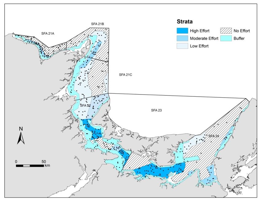
Figure 1. Scallop fishing areas and locations of
scallop fishery buffer zones in the southern Gulf of
St. Lawrence.
Context:
The sea scallop fishery in the southern Gulf of St. Lawrence is mostly a supplementary fishery to the
lobster, herring and groundfish fisheries. Scallops are harvested with mobile gear (drag) using small
vessels. In Fisheries and Oceans Canada (DFO) Gulf Region there are over 700 commercial scallop
fishing licences, although many are inactive. Almost all scallop harvesters hold more than one fishing
licence.
In the Gulf Region, the scallop fishery is important to many coastal communities and dispersed over a
large area. The scallop grounds in the Gulf Region are divided into four Scallop Fishing Areas (SFA)
with one zone (SFA 21) divided into three sub-zones (Fig. 1). There are SFA specific management
measures related to effort controls. In most SFAs, buffer zones that prohibit scallop dragging over
selected habitat have been implemented mainly to protect lobster habitat. First recorded landings were
in the early 1900’s and peak landings of 900 t occurred in 1968. Preliminary landings were just over 66 t
in 2016.
The last assessment of the Gulf Region scallop fishery dates to 2011 (DFO 2011; Lanteigne and
Davidson 1992). To date, stock status has been limited to indices of abundance based on fishery catch
rates with limited and periodic surveys of scallop beds. DFO Ecosystem and Fisheries Management
(EFM) has requested an assessment of the scallop fishery and an assessment of status of the scallop
stock in the southern Gulf of St. Lawrence. This Science Advisory Report is from the October 16 and
17, 2018, regional peer review meeting on the fishery and stock status of the sea scallop (Placopecten
magellanicus) from NAFO Division 4T, southern Gulf of St. Lawrence. Participants at the meeting were
from DFO Science, DFO EFM, provincial governments, industry, and an Indigenous organization.
Additional publications from this meeting will be posted on the Fisheries and Oceans Canada (DFO)
Science Advisory Schedule as they become available.
March 2019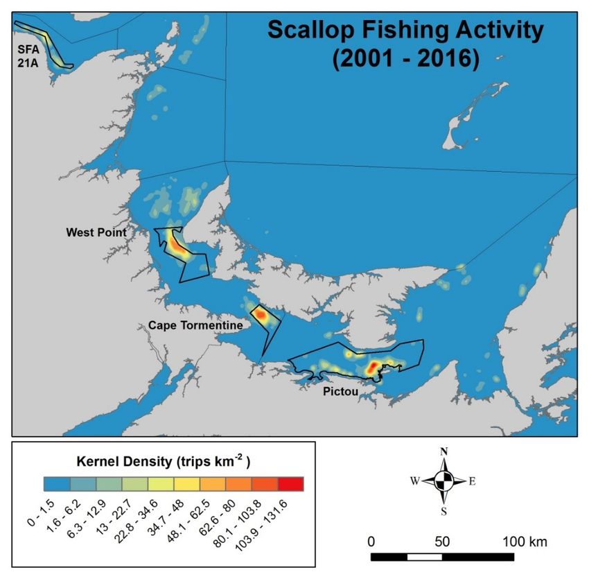
Gulf Region                                           Southern Gulf of St. Lawrence Scallop

SUMMARY
•     The sea scallop fishery in the southern Gulf of St. Lawrence (sGSL) is a competitive fishery
      with fishing effort and landings mostly concentrated on three beds (West Point, Cape
      Tormentine and Pictou) within Scallop Fishing Areas (SFA) 22 and 24, all within the
      Northumberland Strait area.
•     Reported landings have declined from approximately 900 t in 1968 to around 100 t since
      2002. Preliminary reported landings in 2016 were 66 t.
•     There is a large amount of latent effort in this fishery. Just under 20% of the 770 licence
      holders were actively fishing in 2016, based on reported landings.
•     Missing and inaccurate sales slip and logbook information are the main drivers of
      uncertainty of the landings and the effort data that are used in this assessment.
•     Catch rates derived from logbook information are generally low (6 kg per h) and decline
      rapidly within a few weeks of the fishery opening in most areas.
•     Depletion models were used to develop relative indices of annual fishery exploitable
      biomass and exploitation rates. Despite the uncertainties in the data and the modelling
      assumptions to be respected, there is evidence of a rapid depletion over a period of a few
      weeks of the estimated exploitable biomass in the major scallop beds in SFA 22.
•     Indices of commercial sized biomass of scallop from research surveys on the major beds in
      singular years provide further evidence of relatively high exploitation rates in this fishery
      taking place on a stock at low abundance.
•     The abundance indices, based on catch rates and densities, of scallop in the southern Gulf
      are considered to be at low levels relative to other areas of eastern Canada.
•     Biological characteristics data from research surveys show evidence of recruitment (< 80
      mm shell height) in each SFA surveyed.
•     There is no information available from the sea scallop stock of the sGSL with which to define
      abundance and removal rate reference points as per the Precautionary Approach.
•     There are no current indicators that could be used to signal if a significant unexpected
      change in stock status has occurred. However, indices to assess performance of the fishery,
      including landings and catch rates, could be provided by major beds that support the fishery
      in the sGSL.

INTRODUCTION
Biology
The sea scallop (Placopecten magellanicus) is a bivalve mollusc found in the Atlantic coastal
waters from the north shore of the Gulf of St. Lawrence (Canada) to Cape Hatteras, North
Carolina (USA). It is an epibenthic species and a sessile active filter-feeder ingesting
phytoplankton, small zooplankton, ciliates, detrital material and bacteria. Scallops are frequently
found in dense localized aggregations called beds which support commercial fisheries. In the
southern Gulf of St. Lawrence (sGSL), scallop beds are located at depths of 15 m to 37 m. Sea
scallops seem to prefer sand-gravel or gravel-pebble substrate although they are occasionally
found on sand-mud or rocky bottoms.

                                                   2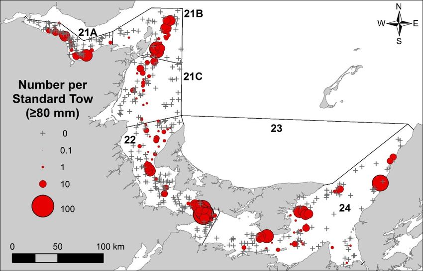
Gulf Region                                                                    Southern Gulf of St. Lawrence Scallop

In the sGSL, the larger scallop commonly reach between 125 and 145 mm in shell height. Sea
scallop growth rates are highly variable, depending on location. Growth occurs at temperatures
ranging from 8 to 18°C while the ideal temperature for growth is around 10°C. Sea scallop prefer
salinities of 30 to 32 ppt but they can tolerate salinities as low as 25 ppt. In the sGSL, scallops
encounter temperatures ranging from -2 to 20°C. The sea scallop show physiological stress at
temperatures between 18 to 23°C but can survive at these temperatures if well acclimated.
Scallop mortality may occur at temperatures above 23°C where mass mortality events have
historically been reported in portions of the southern Gulf.
The sexes are separate in sea scallop and they typically reach reproductive maturity at shell
heights > 70 mm, approximately 3 years old in the sGSL. Fecundity is exponentially related to
the shell height and can vary annually. During the spawning period, the males and females
release their gametes synchronously and fertilisation occurs in the water column. The larvae are
planktonic for 4 to 5 weeks after which time they metamorphose and settle on suitable
substrates to begin their benthic life.
The adductor muscle of the scallop is the part of the organism which is extracted in the fishery.
The meat weight to shell height relationships vary within a season, among SFAs and among
years (Fig. 2).
                                                                 60

                                                                      SFA 22 south 2012
                                                           (g)

                                                                      SFA 21A 2013
                                                                 50
                                               Meat Weight

                                                                      SFA 22 north 2014
                                                    (G)

                                                                      SFA 24 2015
                                                                 40
    SHELL HEIGHT (MM)

                                        MEAT WEIGHT

                                                                      SFA 21BC 2016
                                                                 30
                                                                 20
                                                                 10
                                                                 0

                                                                       20        40       60   80       100        120   140

                                                                                               Shell Height (mm)

Figure 2. Meat weight (g) to shell height (mm) relationships of the sea scallop sampled from five scallop
fishing areas in the southern Gulf of St. Lawrence, 2012 to 2016.

Fishery
Management of the scallop fishery in the sGSL is structured into four Scallop Fishing Areas
(SFA) with one zone (SFA 21) divided into three sub-zones (Fig. 1). Each SFA has its own
management measures (Table 1). Commercial and limited Indigenous Food, Social and
Ceremonial, as well as recreational fisheries for scallop occur in the sGSL. The sea scallop
fishery is competitive, without quotas, and is managed by input controls including a limited
number of licences, fishing seasons, spatial closures, gear restrictions, and meat count limits.
Buffer zones have been implemented to prevent trawling and dredging, including scallop
dredging, over selected areas to primarily protect lobster habitat (Fig. 1).
There are no minimum sizes for commercial scallop harvesting but the size of the scallop
harvested is to a certain extent dictated by the minimum ring size of the drag (82.6 mm). There
is a regulatory meat count (number of scallop meats per 500 grams) that varies by SFA
(Table 1). The regulatory meat count is highest in SFA 24 because of the smaller meat weights
to shell heights in this area (Fig. 2). Fish harvesters are required to shuck the scallop at sea.

                                                                        3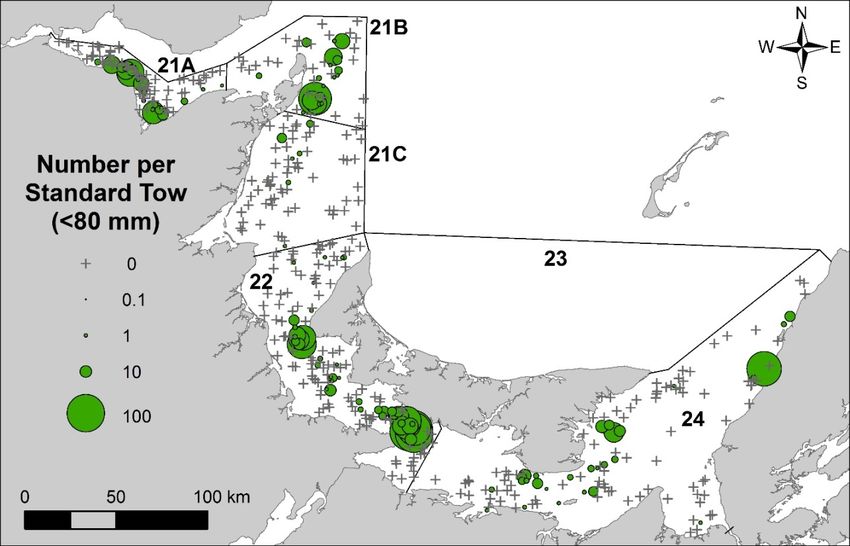
Gulf Region                                                   Southern Gulf of St. Lawrence Scallop

The common practice of blending the catch allows for small scallop to be shucked together with
larger ones while still respecting the meat count limit.

Table 1. Summary of management measures for the scallop fishery in the southern Gulf of St. Lawrence.
    Management                                           Scallop Fishing Area (SFA)
    measure                   21A            21B               21C              22              23          24
    Season in 2015         July 14 to      May 10 to       June 22 to       May 11 to        July 6 to   Oct 26. to
                             Aug 8          Aug. 8           July 24         June 15         Aug. 29;     Nov. 28
                                                                                             Nov. 5 to
                                                                                              Dec 1
    Season in 2016           Closed        May 10 to          July 4 to       May 2 to       July 4 to   Nov. 1 to
                                            Aug. 8a            July 30         June 4        Aug.27;     Dec. 15
                                                                                             Oct.24 to
                                                                                             Nov. 26
    Number of fishing          24             42                 24              30            72b          39
    days in season
    Time open             6:00 to 18:00   5:30 Monday       5:00 to 18:00   6:00 to 17:00c    6:00 to     6:00 to
                                            to 14:00                                           18:00      18:00
                                             Friday
    Days closed           Saturday &       Saturday &         Sunday           Sunday        Sunday       Sunday
                           Sunday            Sunday
    Meat count                35               39                39              44             33          52
    (number per 500 g)
    Ring size (mm)            82.6           82.6               82.6            82.6           82.6        82.6
    Width of dredge (m)        6              6                  6              4.88             6          5
    Tow bar                    ns             ns                 ns        with 50.8 mm         ns          ns
    specificationsd                                                           runners
    Washers                               Steel (8 max) & Chaffing gear or 2 rubbers on the vertical
a maximum of 42 consecutive days within this season
b reduced to 50 in 2017
c 6:00 to 18:00 in 2015
d not specified

Commercial scallop fishing takes place with fishing vessels less than 14 m (45’). Most of the
industry uses a Digby-type drag (Fig. 3). The total length of the drag, the ring size, type and
number washers and tow bar are described in the condition of licence for each SFA (Table 1).
There were 770 to 773 commercial scallop fishing licences issued in 2012 to 2016, including 44
communal commercial licences held by 15 Indigenous groups. Over half of the commercial
licences are in SFA 24 (Table 2). Active licences, estimated from records of landings in statistics
and from logbooks, are much less than issued licences and ranged from 145 to 189 over the
same time period. During 2011 to 2016, between 19% and 25% of the licence holders were
active, i.e. had recorded landings. The highest percentage of active participants has been in
SFA 22 (42% to 54%) and the lowest percentage of active participants has been in SFA 23 (1%
to 10%) (Table 2).
There were 264 recreational licences, by scuba diving, issued in 2016; management measures
in this fishery include a maximum daily limit per diver (50, except SFA 24 which is 100), a
season (May 1 – Oct. 31), and shell height minimum size limit (102 mm). The number of active
licences (reporting landings in logbooks) varied between 11 and 55 over the 2003 to 2016 time
period. Most of the activity occurs in SFA 21.

                                                        4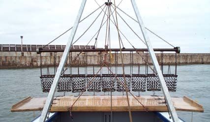
Gulf Region                                                Southern Gulf of St. Lawrence Scallop

Figure 3. Digby-type drag commonly used in the commercial scallop fishery in DFO Gulf Region showing
tow bar and steel ring buckets. In the panel on the right is shown the configuration of the bucket showing
rings linked with steel washers and vertically placed rubber washers.

Table 2. Distribution of commercial scallop fishing licences and estimates of active fishing licences and
total fishing licences (in parentheses) by SFA in 2011 to 2016.
                                                                                                   Active
  SFA     Status              2011         2012        2013        2014       2015        2016    in 2016
  21      Active (total)    6 (103)      3 (103)    11 (103)    15 (103)    3 (103)     6 (103)        6%
    21A   Active (total)     0 (28)       0 (28)      9 (28)     13 (28)     1 (28)      0 (28)        0%
    21B   Active (total)     3 (27)       1 (27)      1 (27)      1 (27)     1 (27)      4 (27)       15%
   21C    Active (total)     3 (48)       2 (48)      1 (48)      1 (48)     1 (48)      2 (48)        4%
  22      Active (total)   97 (202)    109 (201)   101 (200)    92 (200)   84 (200)    83 (200)       42%
  23      Active (total)     1 (78)       2 (78)      2 (78)      8 (78)     6 (78)      5 (78)        6%
  24      Active (total)   77 (390)     75 (390)    68 (390)    63 (390)   52 (389)    51 (389)       13%
  sGSL    Active                181          189         182         178        145         145       19%
          (total)             (773)        (772)       (771)       (771)      (770)       (770)
    Landings
Estimated annual reported landings in the recreational fishery, as reported in logbooks, ranged
between 0.02 t and 0.19 t over the 2003 to 2016 period, mostly (85%) from SFA 21. In terms of
landings, the recreational fishery is considered negligible in comparison to the commercial
fishery and is therefore not included in this assessment.
Commercial landings are monitored through sales slips from registered buyers and logbooks
from scallop harvesters. Logbooks are included in the licence conditions and are mandatory.
Fish harvesters must complete logbooks of fishing activity for each day fished with daily
information including date fished, hours fished, number of tows, average duration of tows in
minutes, landings in pounds, drag width in feet, latitude and longitude of general fishing location,
as well as a comment box for observations such as meat count and anomalies. Commercial
data to 2016 were available for this assessment.
Commercial landings and the number of trips fished in the sGSL scallop fishery to 2016 are
presented in Figure 4. Landings have been low and relatively stable since 2002, averaging 102 t
annually, following a persisting decrease in landings since 1996. Landings for 2015 and 2016
are 71 t and 66 t, respectively, well below the long term (1968 to 2010) mean of 264 t.

                                                     5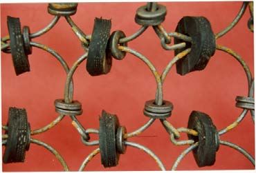
Gulf Region Southern Gulf of St. Lawrence Scallop
landings
1000
Long term (1968-2010) mean Gulf 10000
Number of trips
800 8000
Number of trips
Landings (t)
600 6000
400 4000
200 2000
0 1968 0
1970
1972
1974
1976
1978
1980
1982
1984
1986
1988
1990
1992
1994
1996
1998
2000
2002
2004
2006
2008
2010
2012
2014
2016
Year
Figure 4. Commercial sea scallop landings (tonnes of meat weight) and the number of trips (sum of days
with individual reported landings) in the southern Gulf of St. Lawrence fishery, 1968 to 2016. The long
term mean landing from 1968 to 2010 is shown as the dotted line.
Scallop Fishing Areas were established around 1987 and corresponding annual landings and
number of trips by SFA for the period 1987 to 2016 are shown in Figure 5. On average, landings
from SFA 22 (64%) and SFA 24 (24%) account for 88% of the total annual landings from the
sGSL.
200 21 4000
landings
Number of trips
Number of trips
150 3000
Landings (t)
100 2000
50 1000
0 0
1987
1989
1991
1993
1995
1997
1999
2001
2003
2005
2007
2009
2011
2013
2015
Year
200 22 4000
landings
Number of trips
Number of trips
150 3000
Landings (t)
100 2000
50 1000
0 0
1987
1989
1991
1993
1995
1997
1999
2001
2003
2005
2007
2009
2011
2013
2015
Year
20 23 400
landings
Number of trips
Number of trips
15 300
Landings (t)
10 200
5 100
0 0
1987
1989
1991
1993
1995
1997
1999
2001
2003
2005
2007
2009
2011
2013
2015
Year
200
24 4000
landings
Number of trips
Number of trips
150 3000
Landings (t)
100 2000
50 1000
0 0
1987
1989
1991
1993
1995
1997
1999
2001
2003
2005
2007
2009
2011
2013
2015
Year
Figure 5. Commercial sea scallop landings (tonnes of meat weight) and the number of trips (sum of days
with individual reported landings) in Scallop Fishing Areas (SFA) 21, 22, 23 and 24 in the southern Gulf of
St. Lawrence fishery, 1987 to 2016. Note different y axis scale for SFA 23.
6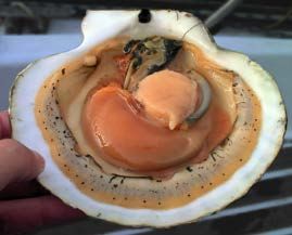
Gulf Region                                                                          Southern Gulf of St. Lawrence Scallop

Logbook records are matched to sales slip from registered buyers. Logbook reported landings
that do not have a corresponding sales slip are interpreted as local sales or personal
consumption. Sales slips without corresponding logbook records of landings are considered
non-compliant to the licence conditions. Over the period 2001 to 2016, compliance has been
variable over the years but seemingly deteriorating for SFA 22, with compliance rates of about
70% since 2012 (Fig. 6). There is no mechanism in place at the present time to quantify
unreported landings, i.e., landings that were not purchased by registered buyers (i.e. no sales
slips) and not recorded in logbooks.
                                                        100
                    Percent Fishing Days Reported (%)

                                                         95
                                                         90
                                                         85
                                                         80
                                                         75
                                                         70
                                                         65
                                                         60
                                                         55
                                                         50

                                                        SFA 21A   SFA 21B   SFA 21C   SFA 22   SFA 23   SFA 24

Figure 6. The percentage of the commercial fishery sales slips with matching recorded harvests in
logbooks by Scallop Fishing Area in the scallop fishery of the southern Gulf of St. Lawrence, 2001 to
2016. There was an insufficient number of reports from SFA 23 in 2007 for a reliable calculation.

The spatial distribution of effort, based on geographic positions reported in logbooks for each
day of fishing during 2001 to 2016 (Fig. 7), corresponds with scallop beds delineated from past
surveys and indicates that the scallop bed locations in the sGSL have been stable over time.
Fishing effort occurs primarily on three beds; West Point (SFA 22 north), Cape Tormentine (SFA
22 south) and Pictou (SFA 24), all within the Northumberland Strait. Approximately 80% of the
Gulf landings are harvested from these three beds alone. Marginal beds, in terms of effort and
landings are in Chaleur Bay (SFA 21A), Miminegash and Cap St Louis (SFA 22 north), and
Wood Island (SFA 24).

                                                                                7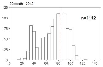
Gulf Region                                                 Southern Gulf of St. Lawrence Scallop

Figure 7. Kernel density plot of scallop fishing trips, expressed as number of trips with positional data per
km², for the southern Gulf of St. Lawrence commercial scallop fishery, summed over years 2001 to 2016.
Fishing effort occurs primarily in three main scallop beds; from north to south, West Point and Cape
Tormentine in SFA 22 and Pictou in SFA 24. Also shown are the respective survey sampling strata (black
line) used during the scallop research surveys (2012 to 2016), which are used to define the scallop bed
for catch rate and other estimates of abundance.

ASSESSMENT
Fishery dependent data – size of the catch
The size (shell height) distributions of scallop in the commercial fishery were described from at-
sea sampling programs conducted during 2001 to 2005 (Davidson et al. 2011). The size
distribution of scallop retained in the commercial gears are strongly peaked in the vicinity of
90 mm, and decline rapidly on either side of this mode (Fig. 8). The truncated distribution above
90 mm reflects the relative lower abundance of these large animals in the Cape Tormentine and
Pictou beds. This pattern is consistent among years and reflects the size selectivity of the
commercial drag (minimum ring diameter 82.6 mm) for the larger sizes.

                                                     8
Gulf Region Southern Gulf of St. Lawrence Scallop
a) b)
c) d)
Frequency
e) f)
Shell height (mm)
Figure 8. Example of shell height distribution of scallop based on sea sampling (2001 to 2005) of the
fishery catches (left column; a,c,e) and from research surveys (2012 to 2016) using a14 mm liner (right
column; b,d,f) from West Point (SFA 22 north; top row, a, b), Cape Tormentine (SFA 22 south; middle
row, c,d) and Pictou (SFA 24; bottom row, e,f) scallop beds, southern Gulf of St. Lawrence. The red
vertical dashed line in each panel shows the 82.6 mm mark corresponding to ring size.
Fishery dependent data - catch rates
Logbook data are used to calculate the catch per unit effort (CPUE) expressed as kilograms of
scallop meat divided by hours towed of fishing effort (kg per h). Here, hours towed is simply the
number of tows multiplied by the average duration of tows. Landings are assigned to scallop
beds within SFAs. Landings within an SFA without specific fishing locations are assigned to
beds by proration based on landings data from the SFA with positional information.
SFA 21A
During 2001 to 2016, annual landings from SFA 21A accounted for 34% to 96% of SFA 21
landings, except for the years 2010 to 2012 as well as 2016 when the SFA 21A fishery was
closed (Fig. 9). Mean catch rates varied from a low of 1.9 kg per h (in 2009) to a peak of 5.3 kg
per h (in 2013). The highest catch rate in the time series was recorded in 2013 after a three year
closure of the SFA. Catch rates at the start of season were around 7.4 kg per h in 2013 and 2.8
kg per h in 2014 and declined to 3.5 and 1.9 kg per h by the end of the four week season,
respectively. Weekly cumulative catch shows that over 75% of the catch is reached by the end
of the third week.
9Gulf Region Southern Gulf of St. Lawrence Scallop
a) 21A b) West Point
10 4500 10 4500
Catch Rate (kg/h)/ Landings (t x 10)
Catch Rate (kg/h) / Landings (t x 10)
9 4000 9 4000
8 3500 8
Effort (hours towed)
3500
Effort (hours towed)
7 3000 7 3000
6 6
2500 2500
5 5
2000 2000
4
Fishery closed
Fishery closed
4
3 1500 1500
3
2 1000 2 1000
1 500 1 500
0 0 0 0
Landings Catch Rate Effort Landings Catch Rate Effort
c) Cape Tormentine d) Pictou
Catch Rate (kg/h) / Landings (t x 10)
10 4500 10 4500
Catch Rate (kg/h) / Landings (t x 10)
9 4000 9 4000
8 8 3500
Effort (hours towed)
3500
Effort (hours towed)
7 7 3000
3000
6 6
2500 2500
5 5
2000 2000
4 4
1500 3 1500
3
1000 2 1000
2
1 500 1 500
0 0 0 0
Landings Catch Rate Effort Landings Catch Rate Effort
Figure 9. Annual catch rates (kg per hours towed) and estimated effort (hours towed) from logbooks, and
corresponding landings data based on logbooks, 2003 to 2016 for a) SFA 21A (upper left panel) b) West
Point bed (SFA 22, upper right panel), c) Cape Tormentine bed (SFA 22, lower left panel), and d) Pictou
bed (SFA 24, lower right panel). Scallop fishing beds are shown in Figure 7. For the Cape Tormentine,
there was a partial closure of the western portion in 2005 to 2010 (landings in grey hatch, catch rates in
solid pink and effort in dashed blue).
SFA 22
SFA 22 landings for the logbook time series (2001 to 2016) varied annually from a maximum of
91 t (2001) to low of 32 t (2016) following five years of declining landings, effort, and catch rates.
The majority of SFA 22 landings are shared between the Cape Tormentine and the West Point
beds (Fig. 7). Seasonally, the partition between the two beds varies, sometimes starting with a
higher proportion of landings from Cape Tormentine in the first weeks of the season and ending
with a higher proportion of landings from West Point or vice versa. Weekly cumulative landings
show that 73% to 94% of the total landings are generally taken by the end of the third week.
Annual catch rates averaged 6.0 kg per h, fluctuating between 4.4 kg per h (2006) and 8.1 kg
per h (2013) since the beginning of the time series in 2003.
West Point
During 2001 to 2016, annual landings from the West Point bed represented 9% to 64% of SFA
22 landings. Low landings in 2016 may reflect small meat weights in relation to shell size as
reported by fish harvesters. Mean annual catch rates for the 2003 to 2016 period varied from a
low of 3.6 kg per h (2016) to 7.4 kg per h ( 2011) (Fig. 9). There is a general decline in catch
rates over the five-week fishing season. The weekly catch rates at the start of the season are at
10Gulf Region Southern Gulf of St. Lawrence Scallop
about 8 kg per h (range: 4.5 to 9.5 kg per h). The season typically ends with catch rates at
around 4 kg per h (range 3.2 to 5.5 kg per h).
Cape Tormentine
There was a partial closure of the western portion of the Cape Tormentine bed in 2005 to 2010.
During 2001 to 2016, landings from the Cape Tormentine bed accounted for 12% to 80% of
SFA 22 landings. Mean annual catch rates for the 2003 to 2016 period varied from 3.4 kg per h
(2005) to 9.5 kg per h (2013) (Fig. 9). Landings, effort and catch rates all increased and peaked
in 2013. A breakdown of catch rates by week depicts a general decline over the five-week
fishing season, and this trend is consistent yearly. The catch rates at the start of the season are
higher than those for the West Point bed at about 10 kg per h (range: 7.3 to 12.2 kg per h) and
end at around 5 kg per h (range: 3.5 to 6.2 kg per h). Effort also tends to decline over the
season.
SFA 24
In contrast to other SFAs, a majority of the landings (65%) recorded in logbooks from SFA 24
are local sales. Annual catch rates over the 2003 to 2016 time series averaged 3.6 kg per h and
varied within a narrow range of 2.6 kg per h (2005) to 4.6 kg per h (2016).
Pictou Bed
A large percentage (66% to 86%) of the landings from SFA 24 is taken from the Pictou bed.
During 2003 to 2016, catch rates varied from 2.7 kg per h (2005) to 4.4 kg per h (2016) and
were generally higher post 2009 (Fig. 9). The catch rates are generally lower than for the two
major beds in SFA 22. In contrast to the seasonal pattern of catch rates from scallop beds in
SFA 22, there was little variation in the catch rates from the Pictou bed over the six or seven
weeks of fishery activity. The mean catch rates from the start to end of the season are low, at
about 4.5 kg per h (range: 2.7 to 4.8 kg per h). More than 75% of the landings are caught by the
end of week five. On average, meat weights for a given shell height are lower in this SFA than in
the other areas (Fig. 2; DFO 2011).
Fishery dependent data – depletion estimates of biomass and exploitation rate
A stock assessment depletion model was applied to the logbook reported data of landings and
effort (kg per h) for the most important scallop beds in the sGSL. Logbook and landings data
considered for each bed were defined by the survey strata shown in Figure 7. The model is
used to estimate the fishery exploitable biomass (B0) prior to fishing and the annual exploitation
rate for the bed. For the depletion model, the estimates are for the effective area fished which
may be smaller than the stratum area, and may vary over years.
Daily cumulative landings are the sum of the daily reported landings (per SFA or bed) up to that
day. Daily commercial catch rates (kg per h) are obtained from the logbook data. A statistically
significant model is one for which the slope of the linear relationship between daily catch rate
and cumulative catch over the season is significantly different from zero, and negative in sign.
Depletion models have a number of assumptions, the most important being that the index of
abundance (catch rate) is proportional to exploitable biomass and that catchability is constant
within the season.
Considering the uncertainties associated with the data input and model assumptions, only the
mean results from the depletion model are presented to provide a relative index of exploitable
biomass and exploitation rate.
11Gulf Region Southern Gulf of St. Lawrence Scallop
SFA 21A
The SFA 21A commercial landings and catch rate data for 2003 to 2006 and 2013 were
amenable to depletion analysis; in the other years the data were not statistically informative (no
decline in catch rates over the season) or the fishery was closed. The estimated initial
exploitable biomass and exploitation rates are shown in Figure 10. The estimate for the
exploitable biomass before the fishery in 2003 and 2004 was 45 t and 55 t, respectively, but
declined rapidly to 15 t by 2006.
Following the three years of the fishery closure in 2010 to 2012, the estimate of the exploitable
biomass before the fishery in 2013 was only 8 t, of which 5 t were estimated to have been
landed in this area. The catch rates declined rapidly from 8 kg h-1 at the start of the season to
3 kg per h when the fishery ended in week 4.
Estimated exploitation rates have been above 30% every year of the assessment, and were
over 60% in 2013 (Fig. 10).
21A 21A
140 1.0
120 0.9
Exploitation Rate
0.8
100 0.7
Biomass (t)
80 0.6
0.5
60
0.4
40 0.3
20 0.2
0.1
0 0.0
2002 2004 2006 2008 2010 2012 2014 2016 2002 2004 2006 2008 2010 2012 2014 2016
Figure 10. Depletion model estimates of relative fishery exploitable biomass (B0; left panel, t) at the start
of the fishery and exploitation rate (right panel) for the scallop bed in SFA 21A from 2003 to 2006 and
2013.
SFA 22
SFA 22 West Point bed
The depletion model, fit to the West Point commercial landings and catch rate data for 2003 to
2016, was significant for all years. Over the time series, the exploitable biomass estimates
before the fishery varied between 7 t (2016) and 83 t (2007) and averaged 55 t. Annual
exploitation rates varied from 22% to 65% (Fig. 11).
SFA 22 Cape Tormentine bed
The depletion model, fit to the Cape Tormentine bed commercial landings and logbook catch
rate data, was statistically significant for all years (2003 to 2016) and indicated strong within
season depletion of the exploitable biomass. Over the time series, exploitable biomass before
the fishery fluctuated from a low of 12 t (2005) to 112 t (2013) and averaged 43 t over the time
series (Fig. 11). Annual exploitation rates varied from 42% to 62%.
12Gulf Region Southern Gulf of St. Lawrence Scallop
West Point Cape Tormentine
140 140
120 120
100 100
Biomass (t)
Biomass (t)
80 80
60 60
40 40
20 20
0 0
2002 2004 2006 2008 2010 2012 2014 2016 2002 2004 2006 2008 2010 2012 2014 2016
1.0 1.0
0.9 0.9
0.8 0.8
0.7 0.7
Exploitation rate
Exploitation rate
0.6 0.6
0.5 0.5
0.4 0.4
0.3 0.3
0.2 0.2
0.1 0.1
0.0 0.0
2002 2004 2006 2008 2010 2012 2014 2016 2002 2004 2006 2008 2010 2012 2014 2016
Figure 11. Depletion model estimates of fishery exploitable biomass (B0) at the beginning of the fishery
(top row) and estimates of exploitation rate (bottom row) for the major scallop beds in SFA 22 (West Point
left column; Cape Tormentine right panel) in the southern Gulf of St. Lawrence, 2003 to 2016.
SFA 24
The depletion model relating catch rates and cumulative landings from the Pictou bed of SFA
24 was significant for only one year, 2011. The catch rates are very low for this area and there
are little to no declines in catch rates over the season. The model estimate for exploitable
biomass before the fishery in 2011 was 42 t for a corresponding exploitation rate of 28%.
Fishery independent data
An annual, rotational, multispecies research survey program for scallop in the sGSL was
initiated in 2012 to obtain fishery independent indices of abundance, biomass estimates, and
biological characteristics information (shell height, meat weight, sex, clappers). One section of a
SFA or the SFA in its entirety was surveyed per year, with the exception of SFA 23 which was
excluded because of the low scallop fishing effort reported from this area in recent years. A
stratified random design, with strata defined by sea scallop commercial fishing effort
distributional patterns, was used to sample waters of depth greater than 5.5 m (Fig. 12).The
number of survey tows was allocated proportionally to the size of the stratum and subsequently
weighted by fishing effort to assign more stations where fishing effort was highest. An eight-
gang Digby scallop drag was used as the survey fishing gear, with buckets lined with a Vexar®
liner of 14 mm mesh size to retain the scallop recruits and small benthic species. At each
sampling station, a 2 minute tow at a speed of 2.5 knots was conducted.
The catch data were standardized to a tow area of 437.3 m² (target tow duration of 2 minutes at
2.5 knots multiplied by the inside width of the gear of 2.8 m). The mean abundance and weight
per standard tow were calculated for each stratum. The abundance (number) and biomass
13Gulf Region Southern Gulf of St. Lawrence Scallop
(meat weight) of scallop, uncorrected for gear efficiency, are reported for the main scallop
fishing areas which are defined by the survey stratum corresponding to high effort (Fig. 12).
The surveys conducted in SFA 21A and SFA 24 occurred before the fishery whereas the
surveys in SFA 22, SFA 21B and 21C occurred after the fishery.
Figure 12. Survey strata and positions of randomly assigned (by stratum) sampling tows (black dots) for
the scallop surveys in the southern Gulf of St. Lawrence during 2012 to 2016. Note that SFA 22 is divided
into SFA 22 north and SFA 22 south and strata were assigned to each. Similarly for SFA 21A, SFA 24,
and for the combined 21B and 21C.
Spatial distribution
With the exception of SFA 24, the spatial distribution of scallop from the survey is in agreement
with the commercial fishery data from logbooks (Figs. 13 and 14). For SFA 24, the high fishing
effort stratum is large and the random allocation of stations was not optimal to sample the
concentrations in the Pictou bed, which is one of the major fishing areas in this SFA.
In general, the distribution of small scallop (< 80 mm) (Fig. 13) and commercial-sized scallop (≥
80 mm) (Fig. 14) spatially overlapped.
The highest density of scallop (all sizes) was found in SFA 22 south with a mean of 8.6 scallop
per tow (0.02 scallop per m2) and the lowest densities were found in SFA 21B and 21C
(1.8 scallop per tow; < 0.01 scallop per m2). Maximum densities in a tow varied from
0.17 scallop per m2 (SFA 21A) to 0.44 scallop per m2 (SFA 22 south).
14Gulf Region Southern Gulf of St. Lawrence Scallop
Figure 13. Spatial distribution of sea scallop abundance indices (total number per standard tow) of small
size (< 80 mm) scallop in the southern Gulf of St. Lawrence surveys, 2012 to 2016. Circle area is
proportional to scallop density.
Figure 14. Spatial distribution of sea scallop abundance indices (total number per standard tow) of
commercial size (≥ 80 mm) scallop in the southern Gulf of St. Lawrence surveys, 2012 to 2016. Circle
area is proportional to scallop density.
15Gulf Region Southern Gulf of St. Lawrence Scallop
Biological characteristics
Biological characteristics of scallop sampled during the research survey are summarized in
Table 3 and Figures 8 and 15. The age of the sea scallop retained by the survey drag ranged
from 2 to 16 years old. The maximum age observed in SFA 22, SFA 21B and 21C was 13 years
old. An index of natural mortality, based on the ratio of clappers (dead scallop with the two
shells still attached at the hinge) of scallop shell heights ≥80 mm, ranged from 0.07 in SFA 21B
and 21C to 0.38 in SFA 22 south, similar to rates reported in Lanteigne et al. (1987) (Table 3).
These indices can be affected by the period when the data are collected; as for example fishery
activity can affect the deterioration of the clappers through physical interactions with the gear.
The shell height size frequency distributions from the survey catches are shown in Figure 15.
Scallop recruitment (< 80 mm shell height) is evident in all sampled areas. In SFA 21A, pre-
recruits sizes (< 80 mm) are abundant, while fewer scallop fall in the size range between 80 and
110 mm. There are very few scallop greater than 110 mm in SFA 22 south and the maximum
recorded at this site was only 125 mm. There are fewer small scallop in SFA 24, where 50% of
all scallop are greater than 86 mm. Predicted meat weight of a scallop of 100 mm shell height is
lowest in SFA 24 and highest in SFA 22 north (Table 3; Fig. 2).
Frequency
Shell height (mm)
Shell height (mm)
Figure 15. Shell height distribution of scallop by SFA based on research surveys with a scallop drag
bucket liner (14 mm) conducted between 2012 and 2016. The red vertical dashed line in each panel
shows the 82.6 mm mark corresponding to ring size.
16Gulf Region Southern Gulf of St. Lawrence Scallop
Table 3. Number of scallop sampled (n), shell height (mm; mean, standard deviation, size range),
predicted mean weight of a scallop of 100 mm shell height, mean age and maximum age of commercial
scallop (≥ 80 mm), and ratio of clappers in the catches of sea scallop from the research vessel scallop
survey in the scallop fishing areas of the southern Gulf of St. Lawrence, 2012 to 2016.
Predicted Age of scallop
Shell Height (mm) meat weight ≥ 80 mm Clapper
(g) of 100 mm ratio
SFA Year n Mean SD Min Max shell height Mean Max (≥80 mm)
21A 2013 255 68 22.0 17 147 15.6 8.8 15 0.36
21BC 2016 499 82 34.9 18 143 14.8 8.5 13 0.07
22 north 2014 395 76 26.6 20 156 18.2 6.9 13 0.14
22 south 2012 1,112 72 29.4 15 125 14.3 7.3 13 0.38
24 2015 536 84 27.3 13 137 12.2 8.6 16 0.23
Biomass estimates
SFA 21
SFA 21A in Chaleur Bay was surveyed before the fishing season, June 28 to July 5, 2013. The
mean density of commercial sized scallop (≥ 80 mm shell height) in the scallop bed was 0.033 g
per m2 (0.14 kg per standard tow) (Table 4). The total meat weight of commercial size scallop
before the fishery was estimated to be 8 t (Table 4). At a harvest of 5 t in 2013 for this area, the
exploitation rate based on the index of commercial biomass, unadjusted for gear efficiency,
would be 59%.
Table 4. SFA specific research vessel scallop survey commercial size (≥ 80 mm shell height) biomass
indices (not corrected for drag efficiency) of scallop as meat weight (kg per standard tow of 437.27 m2;
mean, standard error (SE)), density (g m-2), corresponding area for the high effort stratum (km²),
estimated biomass (meat weight, t), pro-rated landings to the stratum, and exploitation rate
Caracteristic SFA 21A SFA 22 north SFA 22 south SFA 24
Year 2013 2014 2012 2015
Abundance (kg per standard tow)
Mean 0.014 0.041 0.223 0.023
Standard error 0.006 0.012 0.057 0.008
Density (g per m²) 0.033 0.090 0.510 0.050
Surface area of the stratum (km²) 231 557 248 1500
Biomass (t) before the fishery 8 84 158 80
Landings (t) 5 32 31 14
Exploitation rate 59% 38% 20% 18%
SFA 22 West Point
SFA 22 West Point bed was surveyed after the fishing season between May 31 and June 11,
2014. The estimated meat weight of commercial size scallop is equivalent to 52 t. The pre-
fishery commercial-sized biomass index, considering the landings that had occurred prior to the
survey, is estimated at 84 t giving an estimated exploitation rate of 38% (Table 4).
SFA 22 Cape Tormentine
SFA 22 Cape Tormentine bed was surveyed after the fishing season between June 27 and July
5, 2012. The estimated meat weight of commercial size scallop in the survey is equivalent to
127 t. The pre-fishery commercial size biomass index, considering the landings that occurred
prior to the survey, is estimated at 158 t giving an estimated exploitation rate of 20% (Table 4).
17Gulf Region Southern Gulf of St. Lawrence Scallop
SFA 24 Pictou
SFA 24 Pictou bed was surveyed before the fishing season between August 14 and 29, 2015.
The estimated meat weight of commercial size scallop in the survey is equivalent to 80 t
(Table 4). The estimated exploitation rate for a harvest of 14 t is 18%.
Stock status from depletion models versus surveys
Estimated exploited biomass indices from the depletion models are generally lower than the
survey commercial size biomass indices for the corresponding years where both are available.
In part, this could be explained by differences in the components of the scallop population which
are included in the biomass estimates. The research vessel scallop gear had a liner and the
size distribution of the scallop in the catch indicated a higher retention rate (higher relative
selectivity) for scallop between 80 and 90 mm shell height than is indicated for the commercial
gear (see Fig. 8 for examples). In addition, the depletion model estimates of biomass are driven
by the catch rates and depletion on the bed area of high abundance which is smaller in surface
area than the survey stratum used to define the research vessel commercial biomass indices.
This difference in biomass estimates results in higher exploitation rates inferred from the
depletion model than from the survey estimates.
Reference points
There is insufficient information available from the sea scallop stock of the sGSL with which to
define abundance and removal rate reference points as per the Precautionary Approach
(DFO 2009).
The time series of reliable landings begins in 1968, with the highest landings at the start of the
time series and showing generally continuous declines since (Fig. 4). Reliable effort data are
only available since 2003. As there is no information on effort, and no estimates of exploitation
rates or of stock abundance for the earlier time period, the status of the scallop resource is
poorly known. Based on research survey estimates of commercial biomass indices from the
three major scallop beds in the sGSL during 2012 to 2015, landings at the levels reported in the
late 1960s could not currently be realized, even if the entire commercial biomass was removed
by the fishery.
Catch rates based on information which more accurately reflects actual fishing effort (number of
tows and average duration of tows) are only available since 2003, corresponding to a time
period when the resource was already considered to be at low abundance in the sGSL
(DFO 2011). Catch rates from the sGSL fishery, generally less than 10 kg per h even at the start
of the fishery and which decrease rapidly over a period of a few weeks, are low relative to those
from other scallop fisheries in eastern Canada.
In SFA 21A, the fishing industry established a minimum catch rate (3 kg per h) below which the
area would be closed to scallop fishing for a minimum of three years. Density of scallop on the
beds, as a metric for spawner density therefore used as a proxy for successful reproduction,
could be developed to establish abundance reference points. Detailed population level
information (stock and recruitment) to develop such an index is not available at the present time.
Stock status for this resource could be monitored using demographic and life history
characteristics that may reflect whether the productivity (growth, survival, reproduction) of the
stock could be severely impaired, as per the definition of a stock being in the critical zone.
Examples of such metrics could include periodic monitoring of the size composition on exploited
scallop beds to ensure that recruitment is not compromised, based on the relative size
distribution of scallop from the research survey using a scallop drag with a liner to catch small
18Gulf Region Southern Gulf of St. Lawrence Scallop
scallop. Indices of natural mortality as derived from clapper ratios could provide a signal of
changes in mortality, with particular concern for any evidence of increases over time. Finally,
condition expressed as meat weight for a standardized length of 100 mm particularly prior to
gonad maturation and spawning could be used to assess the productive capacity of the stock.
Sources of Uncertainty
Both fishery independent and fishery dependent data to assess the status of the scallop stocks
in the sGSL are poor.
Fishery independent data derived from directed research surveys are sporadic and a synoptic
survey of the sGSL scallop beds in the same year has not been conducted since 1986. Much of
scallop fishing area in the sGSL is amenable to scallop dragging, being generally near shore
and in relatively shallow water. Rotational surveys provided intermittent information on the
scallop resource but in the absence of replication through time, this information is of limited use
in assessing stock status and developing management advice.
Fishery dependent data include landings and catch rates derived from sales slips and logbooks.
Missing and inaccurate data is the main driver of uncertainty of the landings and the effort data
that are used in this assessment.
• In some areas, non-compliance with logbook conditions is relatively high, as demonstrated
by the number of fishing trips reported in logbooks in relation to that reported in sales slips.
• In many cases, the percentage of logbook reports with information that can be used for
quantitative spatial catch rate analysis varied from 45% to 60% of logbook returns.
• A large portion of the uncertainty is associated with inconsistency in the quantification of the
effort, reported either as hours fished or as the number and average duration of tows (hours
towed), even though the units of effort to be reported are specified in the licence conditions.
• Additional issues arose from geolocation of fishing activity. There is only one fishing
coordinate requested per day, even though harvesters may fish at multiple locations in a
day. In some logbooks the same geographic coordinates for multiple days were reported
and it is unknown if this represented repeated fishing at the same location or convenience in
data reporting. Some logbook coordinates are reported in Loran-C which are less accurate
and bring conversion issues.
• There is no mechanism in place at the present time to quantify unreported landings, i.e.
landings without sales slips (including local sales) and for which no logbooks were returned.
Meat condition (meat weight for a standard shell height) is highly variable among fishing
locations, varies within the fishing season as well as interannually. Meat condition variability
may be related to environmental conditions to which the scallop are exposed. Annual variations
in condition may mask or otherwise falsely contribute to perceptions in variations of numerical
abundance, and violate the important assumption in assessments that catch rates are
proportional to abundance. The absence of standardized and systematic monitoring of meat
condition therefore adds substantial uncertainty regarding the use of catch rates, even from
fishery independent data, as an index of stock status.
The depletion estimates can provide a relative index of fishery exploitable biomass provided the
assumptions of such approaches are respected. A key assumption is that catch rates are
proportional to abundance and this relationship has not been confirmed when stock abundance
and catch rates are low, as is the case in the catch rate data for scallop from the sGSL. The
relativity of the index also depends upon an assumption that the spatial area of the stock being
exploited is consistent within the season and among years and this may also not be the case if
19Gulf Region Southern Gulf of St. Lawrence Scallop
there is a temporal pattern in the locations fished, within a bed and between scallop beds. This
switching of effort between beds was apparent, for example in SFA 22 as the effort switched
between the Cape Tormentine bed and the West Point bed in 2013.
The assumption that the clapper ratio can be an index of natural mortality may be inappropriate
in cases when the clapper ratio data are collected after the fishery. Clapper integrity, beyond
natural deterioration of the hinge membrane, can be compromised by interactions with the
fishing gear and by stated fishing practices associated with breaking the clappers when
retrieved before discarding to reduce handling and sorting effort of the catches. The more
relevant information would be obtained when these data are collected prior to the fishery,
particularly if the period from the end of the fishery to the survey exceeds the expected duration
of clappers, 33 weeks for the sGSL. Clapper ratios should also be presented by size group as
the resilience of the membrane may differ according to scallop shell size.
The research vessel surveys conducted in 2012 to 2016 confirmed the locations of scallop beds
inferred previously from fishery effort and landings data. However, the survey design for SFA 24
failed to characterize the main Pictou bed due to the large size of the defined stratum and the
random allocation of stations resulting in no stations being assigned in the high concentration
area.
In all surveys, several survey tows were conducted in areas with few to no scallop. This design
is useful for confirming the location of scallop beds but it is not optimal for quantifying population
abundances. An alternate survey design that focuses the sampling effort on the defined scallop
beds could be more effective at quantifying scallop population abundance, recruitment, and
other life history parameters.
By narrowing down the research survey sampling areas, it may be possible to conduct surveys
on the most important beds on a more frequent schedule than once every five years, as was the
case for the 2012 to 2016 surveys. Such repeated sampling of the population is required to
support the development of stock status indicators and to provide management advice for the
fishery.
Concerns have been raised regarding the effects of changes in environmental conditions,
particularly increases in sea temperatures, on scallop growth, reproduction, as well as survival
in the sGSL. The major scallop beds in the sGSL are located within Northumberland Strait, a
shallow and well mixed area where water temperatures can exceed the optimal temperatures
(10 – 15° C) and even exceed temperatures (> 18° C) that are physiologically stressful for sea
scallop. The consequences of this on the productivity of scallop, independent of fishery effects
on the population, is unknown but should be considered in the next assessment.
CONCLUSIONS AND ADVICE
The sea scallop fishery in the sGSL is an input control competitive fishery with fishing effort and
landings currently mostly concentrated on three scallop beds within SFA 22 and 24, all within
the Northumberland Strait area. Reported landings have declined over the available time series
beginning in 1968, from approximately 900 t to around 100 t since 2002. Preliminary reported
landings in 2016 were 66 t.
There is a large amount of latent effort in this fishery. Just under 20% of the 770 licence holders
in the sGSL were considered to be actively fishing (based on reported landings in 2016), a value
similar to the previous five years. The scallop harvesters are multi-species licence holders, and
price for scallop, as well as participation and access in other fisheries, may play a role in the
changes in the number of active harvesters in the past and in the future. The highest
20Gulf Region Southern Gulf of St. Lawrence Scallop
percentage of active scallop harvester is in SFA 22 (West Point and Cape Tormentine beds),
42% in 2016.
Harvesters are expected to complete logbooks and notify DFO at the end of the season whether
they fished or not. In some SFAs and in some years, there is a relatively high proportion of
active harvesters who are non-compliant with the licence condition, with landings registered to
buyers but not reported in logbooks. The completeness of local sales data in logbooks is
uncertain and local sales are particularly important in some areas, such as SFA 24. Missing and
inaccurate data are the main drivers of uncertainty of the landings and the effort data that are
used in this assessment.
Mean catch rates over the fishing period derived from logbook information are generally low
(6 kg per h). Mean weekly catch rates start at 10 kg per h in Cape Tormentine and 8 kg per h in
West Point and decline rapidly, within a few weeks of the fishery opening, with exception of SFA
24 where catch rates were consistently lower (~ 4 kg per h) throughout the season and years.
Depletion models were examined to develop relative indices of annual fishery exploitable
biomass and exploitation rates, using daily catch rate (kg per h) data from logbooks regressed
against cumulative landings on specific scallop beds. Despite the uncertainties in the data and
the assumptions required to position fishing effort and landings from all commercial harvesters
within the specific scallop beds, there is compelling evidence of a rapid depletion of the
exploitable biomass over a period of a few weeks in the two major scallop beds of SFA 22.
Estimates of commercial sized (≥ 80 mm shell height) scallop biomass, uncorrected for drag
efficiency, from research surveys on the major beds in individual years provide further evidence
of relatively high exploitation rates in this fishery, 20% to 40% and higher for some years
examined. It is very unlikely that the high landings reported at the start of the time series could
be realized from the current commercial biomass of scallop in the sGSL, even if the entire stock
was harvested, indicating that relative to historical levels, the stock is at low abundance.
The abundance indices, based on catch rates and densities, are considered to be low relative to
other areas of eastern Canada. On the other hand, biological characteristics data from research
surveys show evidence of recruitment (< 80 mm shell height) in each SFA.
Reference points that conform to the Precautionary Approach could not be defined at this time.
There are no long term indicators of abundance, productivity, or sustainable exploitation with
which to define appropriate reference points. Catch rates based on the relatively short time
series from fishery logbooks are inherently very uncertain, particularly in terms of being
proportional to abundance. In any case, the catch rate data available are from the recent
decade and represent a time period for which the resource is already considered to be at low
abundance.
Concerns regarding impaired productivity for this resource persist, especially in the context of
low densities of spawners which could compromise successful reproduction and recruitment.
Based on limited research vessel information from the recent time period, there is evidence of
recruitment (< 80 mm shell height) in all surveyed areas, although the recruitments which could
be realized from a healthy stock abundance is unknown.
Fishery independent stock monitoring data and indices are required to appropriately assess the
status of this resource and to provide management advice compatible with the sustainable
fisheries framework. Consideration could be given to undertaking periodic, preferably annual,
surveys of those scallop beds which contribute to the majority of the fisheries effort and
landings. Efficiency in survey design could be achieved by focusing the monitoring efforts on
these scallop beds thus potentially providing an opportunity to monitor the main beds in a single
season. Data from these surveys could be used to monitor the productive state of the resource,
21Gulf Region Southern Gulf of St. Lawrence Scallop
including the condition of scallop meats, indices of recruitment, indices of natural mortality, and
indices of commercial biomass to estimate relative exploitation rates by the fishery.
Fishery dependent data of size (length and meat weight) structure of the catches could be
obtained from regular at-sea sampling programs to more fully characterize the exploited
component of the resource and to track conditions of scallop meats.
OTHER CONSIDERATIONS
DFO (2016) provides advice for the development of indicators which could be used in support of
the multi-year assessment and management cycle for aquatic resources in Canada. For
resources that are on a multi-year management cycle, indicators should be developed to track
stock status in the intervening years between full assessments in order to determine if an
unexpected change in status occurred and that a re-assessment earlier than scheduled is
warranted. The indicators that are developed must meet particular conditions including: that the
indicators are linked proportionally or in some manner to stock status and the indicators must be
part of a systematic monitoring activity. Additionally, the indicator data and analyses must be
available in sufficient time to allow a full assessment to occur if such an action is signaled.
There is no defined multi-year management cycle for sea scallop from the sGSL. The previous
assessment summarized fishery data to 2010. Previous management advice provided for this
fishery has been in the context of gear modifications such as ring size and the establishment of
buffer zones to protect lobster habitat. There are currently no directed monitoring programs for
sea scallop in the sGSL, and the only annual information that could be collated are the landings
and effort data from logbooks. Catch rates, as a proportional index of abundance, based on
these fishery dependent data are highly uncertain, particularly because of the inferred low
abundance of the exploitable biomass.
In the absence of appropriate indicators to indicate if a significant unexpected change in stock
status has occurred, an update of the fishery dependent data could be provided in three years
and a full assessment in five years. Indices that could be collated at that time include landings
and catch rates by SFA and specific to the major beds that support the fishery in the sGSL.
These data are however only available from the statistics sector a full year after the fishery has
ended.
LIST OF MEETING PARTICIPANTS
Name Affiliation
Allen, William Maritime Fishermen's Union (Local 4)
Arsenault, Terry Prince Edward Island Fishermen’s Association
Barrell, Jeff DFO Science Gulf Region
Brow, James North of Smokey Fishermen’s Association
Chapman, Stephen Prince Edward Island Fishermen’s Association
Chaput, Gérald DFO Science Gulf Region
Dauphin, Guillaume DFO Science Gulf Region
Dupuis, Pierre NB Dept. of Agriculture, Aquaculture and Fisheries
Dwyer, Alan DFO Fisheries Management, Gulf NS Area Office
Ferguson, Louis Union des Pêcheurs des Maritimes / Maritime Fishermen’s Union
Fillion, Diana DFO Fisheries Management, eastern NB Area Office
Keith, David DFO Science Maritimes Region
MacEwen, Dave Province of PEI Dept. of Agriculture and Fisheries
Massiera, Josiane DFO Fisheries Management, Gulf Region, Moncton
Niles, Monque DFO Science Gulf Region
Ouellette, Marc DFO Science Gulf Region
22Gulf Region Southern Gulf of St. Lawrence Scallop
Name Affiliation
Ramsay, Laura Prince Edward Island Fishermen’s Association
Ricard, Daniel DFO Science Gulf Region
Rondeau, Amélie DFO Science Gulf Region
Sark, Roger Maliseet Nation Conservation Council
Sameoto, Jessica DFO Science Maritimes Region
Sonier, Rémi DFO Science Gulf Region
SOURCES OF INFORMATION
This Science Advisory Report is from the October 16 and 17, 2018 Regional Peer Review
meeting of the fishery and stock status of the giant scallop (Placopecten magellanicus) from
NAFO Division 4T, southern Gulf of St. Lawrence. Additional publications from this meeting will
be posted on the Fisheries and Oceans Canada (DFO) Science Advisory Schedule as they
become available.
Davidson, L.-A., Biron, M., and Niles, M. 2012. Scallop Fishery Assessment of the Southern
Gulf of St. Lawrence in 2010: Commercial Fishery Data. DFO Can. Sci. Advis. Sec. Res.
Doc. 2012/007. vi + 40 p.
DFO. 2009. A fishery decision-making framework incorporating the Precautionary Approach.
DFO Can. Sci. Advis. Sec. Sci. Advis. Rep. 2006/023.
DFO. 2011. Assessment of the scallop fishery (Placopecten magellanicus) of the southern gulf
of St. Lawrence. DFO Can. Sci. Advis. Sec. Sci. Advis. Rep. 2011/039.
DFO. 2016. Guidelines for providing interim-year updates and science advice for multi-year
assessments. DFO Can. Sci. Advis. Sec. Sci. Advis. Rep. 2016/020.
Lanteigne, M., Davidson, L.-A. 1992. Status of the giant scallop (Placopecten magellanicus)
fishery in the southern Gulf of St. Lawrence (Fisheries and Oceans, Gulf Region) – 1990
update. Can. Manusc. Rep. Fish. Aquat. Sci. 2148
Lanteigne, M., Davidson, L.-A., and Worms, J. 1987. Status of the southern Gulf of St.
Lawrence scallop stocks – 1986. CAFSAC Res. Doc. 87/84. 40 p.
23You can also read