Flight below the minimum safe altitude involving Fairchild - SA227, VH-OZV - Australian Transport Safety Bureau
←
→
Page content transcription
If your browser does not render page correctly, please read the page content below

Flight below the minimum safe
altitude involving Fairchild
SA227, VH-OZV
9 km east of Melbourne Airport, Victoria on 18 January 2021

 ATSB Transport Safety Report
 Aviation Occurrence Investigation - Short
 AO-2021-003
 Final – 25 June 2021
Released in accordance with section 25 of the Transport Safety Investigation Act 2003

Publishing information
Published by:            Australian Transport Safety Bureau
Postal address:          PO Box 967, Civic Square ACT 2608
Office:                  62 Northbourne Avenue Canberra, ACT 2601
Telephone:               1800 020 616, from overseas +61 2 6257 2463
                         Accident and incident notification: 1800 011 034 (24 hours)
Email:                   atsbinfo@atsb.gov.au
Website:                 www.atsb.gov.au

© Commonwealth of Australia 2021

Ownership of intellectual property rights in this publication
Unless otherwise noted, copyright (and any other intellectual property rights, if any) in this publication is owned by the
Commonwealth of Australia.

Creative Commons licence
With the exception of the Coat of Arms, ATSB logo, and photos and graphics in which a third party holds copyright,
this publication is licensed under a Creative Commons Attribution 3.0 Australia licence.

Creative Commons Attribution 3.0 Australia Licence is a standard form licence agreement that allows you to copy,
distribute, transmit and adapt this publication provided that you attribute the work.
The ATSB’s preference is that you attribute this publication (and any material sourced from it) using the following
wording: Source: Australian Transport Safety Bureau

Copyright in material obtained from other agencies, private individuals or organisations, belongs to those agencies,
individuals or organisations. Where you want to use their material you will need to contact them directly.

Addendum

    Page                Change                                                                          Date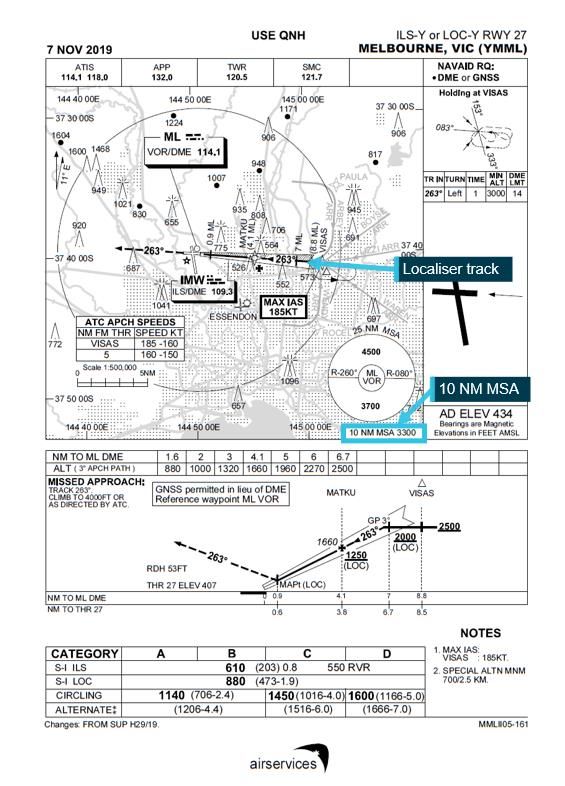
ATSB – AO-2021-003

Safety summary
What happened
On 18 January 2021, at 2029 Eastern Daylight-saving Time, a Sharp Airlines Fairchild SA227
aircraft, registered VH-OZV, departed Launceston Airport, Tasmania for a scheduled freight flight
to Melbourne Airport, Victoria with one pilot on board.
At 2133, the aircraft was being positioned to commence a night-time Instrument Landing System
approach to runway 27 at Melbourne. While joining the approach, a turn was not commenced until
after the aircraft crossed the localiser track.
After crossing the localiser track and while descending along the approach glideslope, the aircraft
descended clear of cloud and the pilot sighted the runway. At that time, the aircraft was positioned
slightly less than full-scale on the course deviation indicator (CDI) to the right of, and tracking
away from, the localiser track. From this position, the pilot elected to continue the approach
visually. However, exacerbated by a prevailing southerly wind, the aircraft continued tracking
away from the localiser and, shortly after, proceeded beyond the full scale of the CDI, requiring
that a missed approach be initiated. Despite that, the pilot assessed that the visual approach
could be continued.
The aircraft continued to deviate from the localiser track and at 2135, reached a maximum lateral
deviation of 0.55 nautical miles. The pilot then turned the aircraft further to track toward the
localiser while continuing to descend. At about the same time, the Melbourne Tower air traffic
controller noticed the deviation and contacted the pilot.
At 2136, at about 980 ft above mean sea level (about 583 ft above ground level), the aircraft was
re-established within full-scale CDI deflection and landed shortly after.

What the ATSB found
The ATSB found that during approach to the airport in darkness, the aircraft was not maintained
within the required navigational tolerance. While that should have resulted in the conduct of a
missed approach, the approach was continued with the aircraft manoeuvring significantly below
the minimum safe altitude.

Safety message
Handling of approaches is one of the ATSB’s SafetyWatch priorities. Adherence to operational
procedures ensures consistency of pilot action and aircraft operation during the approach and
landing phases of flight. This, along with careful monitoring of aircraft and approach parameters,
provides assurance that an instrument approach can be safely completed.
Most importantly, if the criteria for safe continuation of an approach are not met, the pilot should
conduct a missed approach to negate the risk of colliding with obstacles or terrain.

                                                 ›1 ‹
ATSB – AO-2021-003
The investigation
Decisions regarding whether to conduct an investigation, and the scope of an investigation, are based on
many factors, including the level of safety benefit likely to be obtained from an investigation. For this
occurrence, a limited-scope investigation was conducted in order to produce a short investigation report,
and allow for greater industry awareness of findings that affect safety and potential learning opportunities.
The occurrence
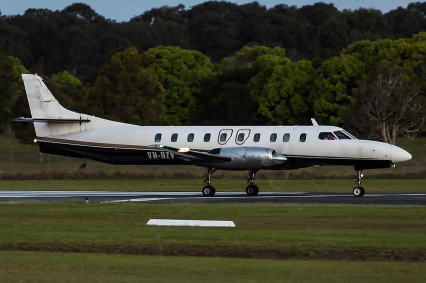
On 18 January 2021, at 2029 Eastern Daylight-saving Time,1 a Sharp Airlines Fairchild SA227
aircraft, registered VH-OZV (Figure 1), departed Launceston Airport, Tasmania for a scheduled
freight flight to Melbourne Airport, Victoria with one pilot on board.
Figure 1: VH-OZV
Source: Jayden Laing
At 2122, the pilot commenced descending the aircraft in darkness from the cruising altitude prior
to starting an Instrument Landing System (ILS) approach (see the section titled Instrument landing
system) to runway 27 at Melbourne. During the descent, and prior to commencing the approach,
the aircraft entered cloud.
At 2133, as the aircraft approached the ILS localiser track from the south-east, in preparation to
intercept the localiser track, the pilot changed the autopilot mode from navigation (NAV) to
heading (HDG).2 The selected heading, in combination with the prevailing southerly wind, resulted
in a 36° intercept angle of the ILS localiser track (Figure 2).
1
Eastern Daylight-saving Time (EDT): Coordinated Universal Time (UTC) + 11 hours.
2
In NAV mode, the autopilot system follows the lateral path commanded by the ILS localiser. When HDG mode is
selected, the autopilot steers the aircraft according to a heading manually selected by the pilot.
›2 ‹ATSB – AO-2021-003
Figure 2: Approach profile
Source: Google earth, annotated by the ATSB
The aircraft crossed the localiser track at the waypoint3 VISAS on a continuation of the intercept
angle. After the aircraft crossed the localiser track, the pilot reselected NAV mode to commence
the intercept and establish the aircraft on the inbound track. However, the autopilot-commanded
turn toward the localiser track did not occur as quickly as the pilot anticipated so HDG mode was
again selected with a commanded heading of 250° magnetic. Soon after selecting HDG mode, the
aircraft approached the ILS glideslope. The pilot reported that the aircraft was still within half scale
of the localiser course deviation indicator (CDI) so commenced descending along the glideslope
and extended the landing gear.
Shortly after intercepting the glideslope, the aircraft descended clear of the cloud base at about
2,000 ft above mean sea level (AMSL) and the pilot sighted the runway. At that time, the aircraft
was positioned slightly less than full-scale CDI deflection to the right of the localiser track and
diverging away at an angle of about 9°. From this position, the pilot elected to continue the
approach visually (see the section titled Night visual approach criteria and Figure 2). The pilot did
not advise air traffic control (ATC) that the approach was continuing visually and was not cleared
by ATC to conduct a visual approach. Had a visual approach clearance been provided, the pilot
would have been required maintain the aircraft within full-scale CDI deflection and above the
glideslope.
The aircraft continued tracking away from the localiser with the autopilot in HDG mode. Shortly
after the pilot had elected to continue visually, about 6.8 NM from the runway 27 threshold, the
aircraft proceeded beyond the full scale of the CDI. The pilot reported that they did not observe the
CDI exceed full-scale deflection.
The aircraft continued to deviate from the localiser track. At 2135:17, the aircraft reached a
maximum lateral deviation of 0.55 nautical miles (NM) and the pilot disconnected the autopilot to
manually intercept the track. At about the same time, ATC personnel in both the Melbourne Airport
3
Waypoint: A defined position of latitude and longitude coordinates, primarily used for navigation
›3 ‹ATSB – AO-2021-003
control tower and Melbourne air traffic control centre observed the aircraft deviating to the north of
the localiser track. The tower controller notified the pilot of the deviation and the pilot responded
‘adjusting’. A few seconds later, the aircraft reached a maximum angular deviation from the
localiser track of 4.92° at about 1,680 ft AMSL.
The pilot then turned the aircraft further to track toward the approach track as it descended. At
2136:20, at about 980 ft AMSL (about 583 ft above ground level), the aircraft was re-established
within full scale CDI deflection.
The aircraft did not significantly deviate from the ILS glideslope angle during the approach and
landed at 2137:39. No defect with the autopilot system or navigation instrumentation was
identified after the occurrence.
Meteorology
At 2130, shortly before the approach, the Bureau of Meteorology (BoM) automatic weather station
at Melbourne Airport recorded the wind being 18 kt from 228° magnetic. Three cloud layers: Few4
at 2,034 ft, Scattered at 2,634 ft, and Broken at 3,634 ft AMSL were also present.
Instrument landing system
An Instrument Landing System (ILS) is an instrument approach procedure that provides lateral
(localiser) and vertical (glideslope) position information necessary to align an aircraft with the
runway for approach and landing. The system uses angular deviation signals from the glideslope
antennas (located approximately 1,000 ft from the runway threshold) and the localiser antennas
(located past the far end of the runway).
The localiser signals provide the angular deviation from the runway centreline, which in VH-OZV
were presented as fly-left or fly-right commands on the CDI. A pilot or the autopilot (in NAV mode)
follows these commands to track the localiser centreline. Localiser deviation was displayed in
units of dots, where typically full-scale deflection (5 dots) equates to 105 m deviation from the
localiser centreline at the runway threshold.
The glideslope signals provide the angular deviation from the nominal glideslope (usually 3°)
which were presented as fly-up or fly-down commands on the glideslope indicator to follow the
glideslope to the decision altitude.
For both the localiser and glideslope, no additional deviation indications are provided beyond full
scale indicator deflection.
Minimum sector altitude
The ILS approach chart (Figure 3) included minimum sector altitudes (MSAs) that provided a
minimum terrain clearance of 1,000 ft above all objects located inside a defined area. Within a
10 NM radius of Melbourne Airport, the MSA was 3,300 ft AMSL.
4
Cloud cover: in aviation, cloud cover is reported using words that denote the extent of the cover – ‘few’ indicates that up
to a quarter of the sky is covered, ‘scattered’ indicates that cloud is covering between a quarter and a half of the sky,
‘broken’ indicates that more than half to almost all the sky is covered, and ‘overcast’ indicates that all the sky is
covered.
›4 ‹ATSB – AO-2021-003
Figure 3: Melbourne Airport runway 27 ILS approach chart
Source: Airservices Australia
Night visual approach criteria
Relevant guidance for the conduct of an instrument approach at night in controlled airspace is
provided in sections 1.1 and 1.5 of the Aeronautical Information Publication (AIP) En Route:
En Route 1.1:
• Paragraph 2.11.2.1 ATC Authorisation
Unless authorised to make a visual approach, an instrument flight rules (IFR) flight must conform
to the published instrument approach procedure nominated by ATC.
• Paragraph 2.11.3.7 Minimum Altitude Requirements
›5 ‹ATSB – AO-2021-003
During the conduct of a visual approach, a pilot must descend as necessary to:
…b. by night:
(1) for an IFR flight:
Maintain an altitude not less than the route segment MSA…until the aircraft is:
…within 10 NM of the aerodrome, established not below the ILS glide path with less than full scale
azimuth deflection.
En Route 1.5:
• Paragraph 1.10 Missed Approach – Standard Procedures
(1) A missed approach must be executed if:
during the final segment of an instrument approach, the aircraft is not maintained within the
applicable navigation tolerance for the aid in use.
Safety analysis
At about 2133, the aircraft was descending toward Melbourne Airport prior to commencing a night-
time ILS approach to runway 27. The intercept of the ILS localiser track did not begin until after the
aircraft had already crossed that track at an angle of about 36°. The southerly wind acting on the
westbound aircraft resulted in it quickly deviating to the right of the localiser track.
While the aircraft continued deviating right of the track, as long as it was within the full-scale CDI
deflection, the pilot was permitted to continue the ILS approach visually only with ATC
authorisation. As this authorisation was not requested and provided, the pilot was required to
adhere to the tracking tolerances of the ILS approach. Therefore, once the aircraft tracked
beyond full-scale localiser CDI deflection, the pilot was required to conduct the published missed
approach procedure.
The pilot reported that they did not observe the CDI exceed full-scale deflection, instead
assessing that the visual approach could be continued. Continuing the approach took the aircraft
significantly beyond the localiser tracking tolerance at altitudes as low as 980 ft AMSL (2,320 ft
below the minimum sector altitude).
As the incident took place at night, the pilot’s ability to visually identify obstacles was limited. The
continuation of the night approach outside of the localiser tolerance and below the minimum
sector altitude was contrary to the required approach requirements. This in turn removed obstacle
clearance assurance, increasing the collision risk to the flight.
Findings
ATSB investigation report findings focus on safety factors (that is, events and conditions that increase risk).
Safety factors include ‘contributing factors’ and ‘other factors that increased risk’ (that is, factors that did not
meet the definition of a contributing factor for this occurrence but were still considered important to include
in the report for the purpose of increasing awareness and enhancing safety). In addition ‘other findings’
may be included to provide important information about topics other than safety factors.
These findings should not be read as apportioning blame or liability to any particular organisation or
individual.
From the evidence available, the following findings are made with respect to the flight below
minimum altitude involving Fairchild SA227, VH-OZV 9 km east of Melbourne Airport, Victoria on
18 January 2021.
Contributing factors
• During approach to the airport in darkness, the aircraft was not maintained within the required
navigational tolerance. While that should have resulted in the conduct of a missed approach,
›6 ‹ATSB – AO-2021-003
the approach was continued with the aircraft manoeuvring significantly below the minimum
safe altitude.
Sources and submissions
Sources of information
The sources of information during the investigation included the:
• operator
• pilot
• Airservices Australia
• Bureau of Meteorology
Submissions
Under section 26 of the Transport Safety Investigation Act 2003, the ATSB may provide a draft
report, on a confidential basis, to any person whom the ATSB considers appropriate. That section
allows a person receiving a draft report to make submissions to the ATSB about the draft report.
A draft of this report was provided to the following directly involved parties:
• operator
• pilot
• Airservices Australia
• Civil Aviation Safety Authority
No submissions were received on the draft report.
›7 ‹ATSB – AO-2021-003
General details
Occurrence details
Date and time: 18 January 2021 – 2134 EDT
Occurrence category: Incident
Primary occurrence type: Flight below minimum altitude
Location: 9 km east of Melbourne Airport, Victoria
Latitude: 37º 41.380' S Longitude: 144º 56.770' E
Aircraft details
Manufacturer and model: Fairchild Industries SA227-AC
Registration: VH-OZV
Operator: Sharp Airlines
Serial number: AC-610B
Type of operation: Charter - Freight
Departure: Launceston, Tasmania
Destination: Melbourne, Victoria
Persons on board: Crew – 1 Passengers – Nil
Injuries: Crew – Nil Passengers – Nil
Aircraft damage: None
›8 ‹You can also read