FLORIDA ANNUAL FIRE WEATHER - OPERATING PLAN FOR - National ...
←
→
Page content transcription
If your browser does not render page correctly, please read the page content below
FLORIDA ANNUAL
          OPERATING PLAN FOR
            FIRE WEATHER

Florida Fire Weather Operating Plan – April 2020   Page 1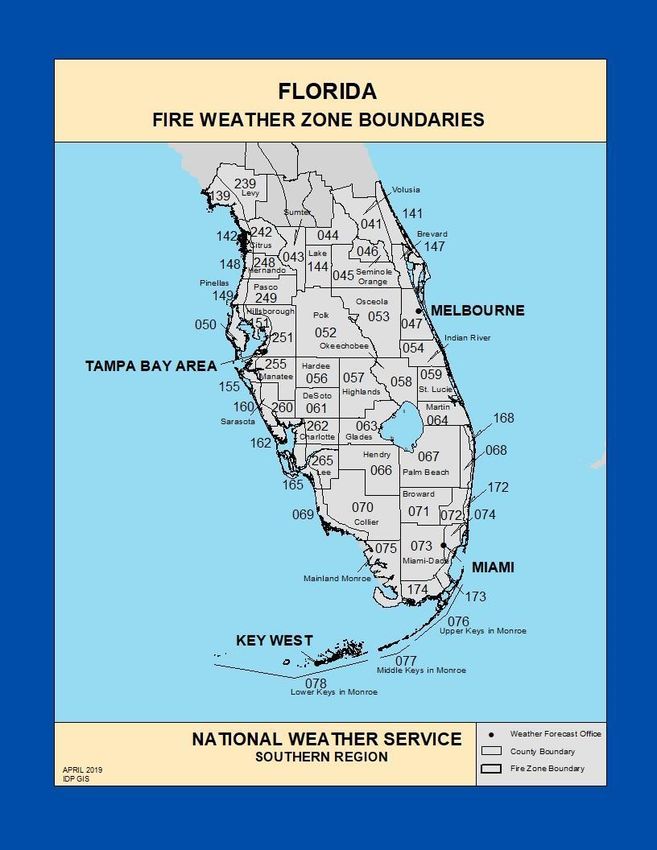
Operating Plan for Fire Weather Services in Florida

April 2020 updates, A. Enyedi, NWS Jacksonville
       - FWF issuance refined to account for Key West 1x day issuance
       - Updated Lightning Activity Level (LAL) – now includes LAL descriptor terms
       - Included IMET request process for Prescribed Burns
       - Updated NWS Melbourne Personnel & Internet Resources
       - Updated FFS District Office Contact Numbers

Table of Contents                                                         Page(s)

I.   Introduction and General Program Information
       List of Participating Federal and State Agencies                   3

II. Service Area and Organizational Directory
       Forecast Area                                                      4-5
       National Weather Service forecast offices and forecast zone        5-7
       Map of Florida NWS forecast zones and offices forecast areas       8-9
       National Weather Service Forecast Office Contacts
               Southern Region Office, Ft Worth, TX:                      10
               Mobile                                                     10
               Tallahassee                                                11
               Jacksonville                                               11
               Tampa Bay (Ruskin)                                         12
               Melbourne                                                  12
               Miami                                                      13
               Key West                                                   13

       Florida Forest Service District Offices                            14

III. National Weather Service Products & Services
       Florida Seasonal Fire Weather Concerns                             15
       National Weather Service Weather Forecasts                         15

A. Fire Weather Planning Forecast (FWF)                                   16-22

B. National fire danger rating system (NFDRS) forecast                    23-25
Florida Fire Weather Operating Plan – April 2020                                      Page 2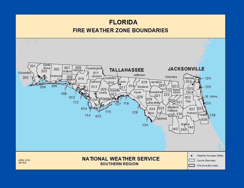
C. The Spot Weather Forecast (FWS) 26-28
D. Fire Weather Watches and Red Flag Warnings (RFW) 29-32
E. On-site NWS Support (IMET) 33-34
F. Other NWS Forecast Services & Products 35-37
IV. Fire Agency Operational Support and Services
Florida Fire Weather Observations 38
Florida Forest Service Observations 38
Relaying Potential Severe Weather Reports to NWS 38
WIMS (NFDRS) Federal Land Management Observations 39
Map & Listing of Florida RAWS Sites 41
V. Appendices
Florida State Park System & FFS Districts 42
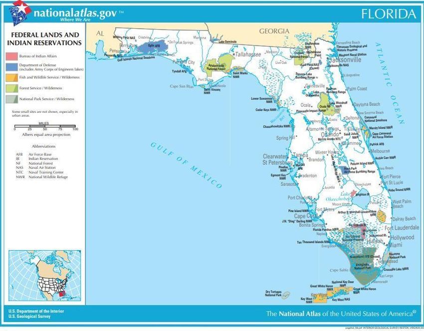
Federally Managed Lands 43
Internet links 44
WIMS Locations 45
NFDRS Florida Zones 46
Keetch-Byram Drought Index 47
I. Introduction and General Program Information
Despite ongoing land development, Florida continues to have expansive areas of forests and
undeveloped land. Preserves, parks, refuges and other publicly and privately owned lands are
found throughout the state from the panhandle to the Florida Keys. Proper management of this
land and its resources is vital to the economy of the state and the preservation of the health
and ecological balance of the environment.
Land management agencies are concerned with the control of wildfire, as well as the use of fire
as a management tool to protect life, property and economic interests. Critical to this mission is
access to timely and accurate weather forecast information which is used in decision making
for wildfire prevention, fire control, prescribed burning, and smoke management.
Florida Fire Weather Operating Plan – April 2020 Page 3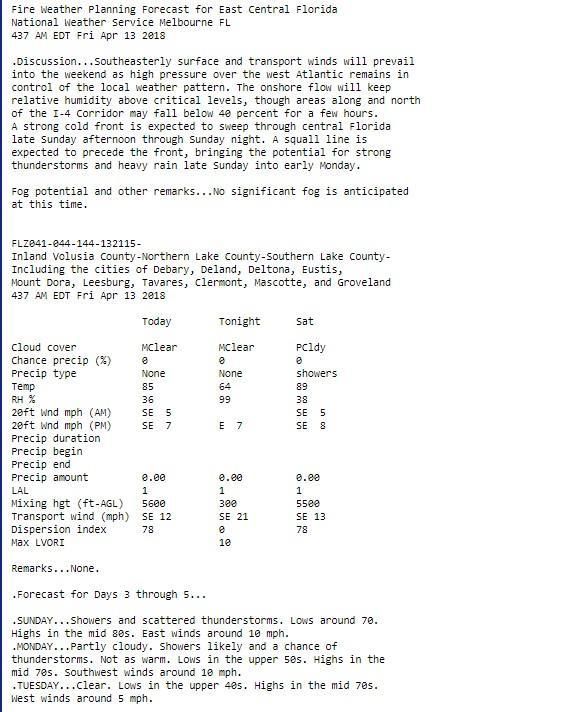
The Florida Annual Operating Plan will be the governing document for fire weather procedures
and cooperation among the following agencies:

       National Weather Service (NWS)              U.S. Forest Service
       U.S. Fish and Wildlife Service              National Park Service
       Department of Defense                       Florida Forest Service
       Florida Park Service                        U.S. Department of Agriculture
       Bureau of Indian Affairs

This Operating Plan conforms to the Interagency Agreement for Meteorological Services, last
reviewed September 2017. Please refer to the following link to access the national agreement:
https://www.weather.gov/media/jax/pdf/Latest_National_Agreement_2017.pdf

The Florida Annual Operating Plan will be reviewed annually and revised as needed. The
annual review and revision (if needed) may be rotated among the Florida NWS offices. The
plan will be reviewed annually by the land management agencies, NWS regional and national
headquarters, and NWS Florida offices.

The National Weather Service Fire Weather Program
(Ref NWS Directive 10-4)

The objective of the National Weather Service fire weather services program is to provide fire
weather products and services to the fire and land management community for the protection
of life and property, promotion of firefighter safety, resource allocation, and stewardship of
America’s public lands.

II. Service Area and Organizational Directory

Forecast Areas

Fire weather forecasts are provided for the state of Florida through the year from seven
National Weather Service offices. These offices are located at Miami, Key West, Melbourne,
Ruskin (Tampa Bay), Jacksonville, Tallahassee, and Mobile, Alabama. NWS forecast offices at
Jacksonville, Tallahassee, and Mobile also have additional forecast areas of responsibility for
areas bordering Florida into Georgia, Alabama, and Mississippi.

Fire weather forecast products are divided into zones. Most zones are counties, however, some
counties have two or more forecast zones to better define forecast differences between inland
and coastal areas.

Site specific forecasts are provided daily for at least one location in each of Florida’s 67
counties. These forecasts are a component of the National Fire Danger Rating System
(NFDRS) to compute fuel moisture and burning indices and to assess wildland fire danger.

Florida Fire Weather Operating Plan – April 2020                                          Page 4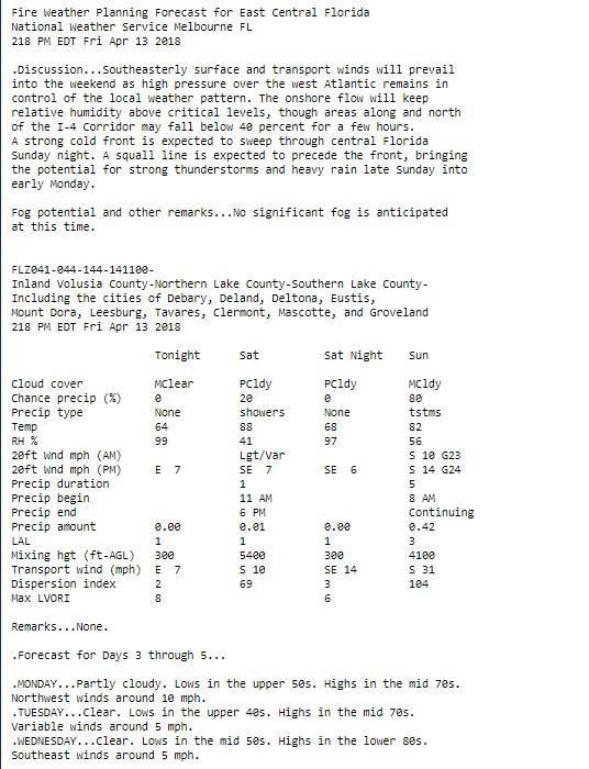
Under the supervision of the Meteorologist-In-Charge (MIC) at National Weather Service
(NWS) offices, forecasters are provided training in fire weather meteorology. Forecast support
is provided 24 hours per day, year round. At least one meteorologist at each National Weather
Service office is designated as the Fire Weather Program Leader and serves as the
interagency liaison. The fire weather program leader serves as the NWS contact for land
management agencies within each National Weather Service forecast office area of
responsibility.

MICs should ensure an updated list of fire weather customers and users are included in the
WFO station duty manual or other appropriate reference. Fire Weather Program Leaders and
other designated NWS team members should lead fire weather outreach and coordination
efforts within their area of forecast responsibility. The NWS Fire Weather Program Leader at
each office must maintain regular contact with fire and land management agencies and help
them assess meteorological needs. Fire Weather Program Leaders will inform fire weather
customers of available NWS products and services. Fire and land management personnel are
encouraged to visit their local NWS Forecast Offices to become familiar with NWS personnel,
operations and services. Similarly, NWS forecast staff are encouraged to visit land
management agencies and operational sites (including observing prescribed burns and visiting
Remote Automated Weather Station (RAWS).

NWS forecast zones and zone number:

Mobile, AL
Inland Escambia        201             Coastal Escambia      202
Inland Santa Rosa 203                  Coastal Santa Rosa    204
Inland Okaloosa        205
Coastal Okaloosa 206 (includes Eglin AFB Okaloosa portion)

Tallahassee
Inland Walton             7            Central Walton          8
Holmes                    9            Washington             10
Jackson                  11            Inland Bay             12
Coastal Bay            112             Calhoun                13
Inland Gulf              14            Coastal Gulf          114
Inland Franklin          15            Coastal Franklin      115
Gadsden                  16            Leon                   17
Inland Jefferson         18            Coastal Jefferson     118
Madison                  19            Liberty                26
Inland Wakulla           27            Coastal Wakulla       127
Florida Fire Weather Operating Plan – April 2020                                        Page 5
Inland Taylor            28            Coastal Taylor            128
Lafayette                29            Coastal Dixie             134
Inland Dixie             34 (includes Apalachicola National Forest)
South Walton           108 (includes Eglin AFB Walton portion)

Jacksonville
Hamilton                 20            Suwannee                   21
Northern Columbia        122           Baker                      23
Southern Columbia 222                  Union                      30
Inland Nassau            24            Coastal Nassau            124
Inland Duval             25            Coastal Duval             125
Bradford                 31             Clay                      32
Western Alachua          236           Eastern Alachua           136
Inland St Johns          33            Coastal St. Johns         133
Gilchrist                35             Putnam                   37
Inland Flagler           38            Coastal Flagler           138
Western Marion           340           Central Marion            240
Eastern Marion           140

Key West
Monroe Upper Keys              76      Monroe Middle Keys        77
Monroe Lower Keys              78

Melbourne
Interior Volusia               41      Coastal Volusia       141
North Lake                     44      South Lake            144
Orange                         45      Seminole                46
North Brevard                  147     South Brevard           47
Osceola                        53      Indian River            54
Okeechobee                     58      St Lucie                59
Martin                         64

Florida Fire Weather Operating Plan – April 2020                       Page 6
Tampa Bay Ruskin
Inland Levy                   239      Coastal Levy          139
Inland Citrus                 242      Coastal Citrus        142
Sumter                          43     Inland Hernando       248
Coastal Hernando             148       Inland Pasco          249
Coastal Pasco                 149      Pinellas               50
Inland Hillsborough           251      Polk                   52
Coastal Hillsborough          151      Inland Manatee        255
Coastal Manatee               155      Hardee                 56
Highlands                       57     Inland Sarasota       260
Coastal Sarasota              160      Desoto                 61
Inland Charlotte              262      Coastal Charlotte     162
Inland Lee                    265      Coastal Lee           165

Miami
Glades                         63       Inland Palm Beach     67
Metro Palm Beach               68      Coastal Palm Beach    168
Coastal Collier                69      Inland Collier         70
Coastal Broward               172      Inland Broward         71
Metro Broward                  72       Inland Miami Dade     73
Metro Miami Dade               74      Coastal Miami Dade    173
Far south Miami Dade          174      Hendry                 66
Mainland Monroe                75 (includes Everglades N.P. & Big Cypress Ntl.Preserve)

Florida Fire Weather Operating Plan – April 2020                                          Page 7
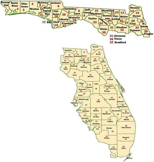
https://www.weather.gov/pimar/FireZones

Florida Fire Weather Operating Plan – April 2020                             Page 8
https://www.weather.gov/pimar/FireZones

Florida Fire Weather Operating Plan – April 2020                             Page 9
National Weather Service Contacts

Southern Region Headquarters National Weather Service

Meteorologist:                 Paul Witsaman, Regional Fire Weather Program Leader
Email:                         paul.witsaman@noaa.gov
Internet home page             www.weather.gov

Mailing Address:               NWS - Southern Region Headquarters
                               Fire Weather Program Leader
                               Paul Witsaman W/SR11x2
                               819 Taylor Street Room 10A06
                               Fort Worth, TX 76102

Telephone:                     817- 978-1100 x116
                               8AM - 4PM CST Mon-Fri (Except Federal Holidays)

Mobile/Pensacola National Weather Service, North Florida

Meteorologists:                Jeff Medlin, Meteorologist In Charge
                               John Purdy, Fire Weather Program Leader
                               Jason Beaman, Warning Coordination Meteorologist
Internet Page:                 www.weather.gov/mob

Mailing Address:               National Weather Service
                               8400 Airport Blvd. Bldg 11
                               Mobile, AL 36608

Telephone:                     251-633-6443
                               8AM - 4PM CST Mon-Fri (Except Federal Holidays)
                               251-406-8612 Fax

Counties of Responsibility:
• Florida: Escambia, Okaloosa, Santa Rosa, Eglin Air Force Base (Okaloosa)
• Alabama: Baldwin, Butler, Choctaw, Clarke, Conecuh, Covington, Crenshaw,
   Escambia Mobile, Monroe, Washington, Wilcox
• Mississippi: George, Greene, Perry, Stone, Wayne

Florida Fire Weather Operating Plan – April 2020                                     Page 10
Tallahassee National Weather Service, North Florida
Meteorologists: Tom Johnstone, Meteorologist in Charge
Tim Barry, Fire Weather Program Leader
Mark Wool, Warning Coordination Meteorologist
Internet Page: www.weather.gov/tae
Mailing Address: National Weather Service
Love Building Florida State University
Tallahassee, FL 32306-4509
Telephone: 850-942-8833 24 Hour
850-942-8850 Fax
Counties of Responsibility:
• Florida: Bay, Calhoun, Dixie, Franklin, Gadsen, Gulf, Holmes, Jackson, Jefferson,
Lafayette, Leon, Liberty, Madison, Taylor, Wakulla, Walton, Washington, All Apalachicola
National Forest, Eglin AFB (Walton).
• Georgia: Baker, Ben Hill, Berrien, Brooks, Calhoun, Clay, Colquitt, Cook, Decatur,
Dougherty, Early, Grady, Irwin, Lanier, Lee, Lowndes, Miller, Mitchell, Quitman,
Randolph, Seminole, Terrell, Thomas, Tift, Turner, Worth
• Alabama: Coffee, Dale, Geneva, Houston, Henry
Jacksonville National Weather Service, Northeast Florida
Meteorologists: Scott Cordero, Meteorologist in Charge
Angie Enyedi, Fire Weather Program Leader/IMET
Al Sandrik, Warning Coordination Meteorologist
Internet Page: www.weather.gov/jax
Mailing address: National Weather Service
13701 Fang Drive
Jacksonville, FL 32218
Telephone: 904-741-4411 ext. 1 (24 hours)
904-741-0078 Fax
Counties of Responsibility:
• Florida: Alachua, Columbia, Hamilton, St Johns, Baker, Duval, Marion, Suwannee,
Bradford, Flagler, Nassau, Union, Clay, Gilchrist, Putnam.
• Georgia: Appling, Camden, Echols, Ware, Atkinson, Charlton, Glynn, Wayne, Bacon,
Clinch, Jeff Davis, Brantley, Coffee, Pierce
Florida Fire Weather Operating Plan – April 2020 Page 11Tampa Bay Area - Ruskin National Weather Service, Peninsula Florida
Meteorologists: Brian LaMarre, Meteorologist In Charge
Rodney Wynn, Fire Weather Program Leader
Rick Davis, IMET
Dan Noah, Warning Coordination Meteorologist
Internet Page: www.weather.gov/tbw
Mailing Address: National Weather Service
2525 14th Avenue SE
Ruskin, FL 33570
Telephone: 813-645-2323 24 Hour
813-641-2619 Fax
Counties of Responsibility: Florida: Charlotte, Citrus, Desoto, Hardee, Hernando, Highlands,
Hillsborough, Lee, Levy, Manatee, Pasco, Pinellas, Polk, Sarasota, Sumter
Melbourne National Weather Service, Peninsula Florida
Meteorologists: Dave Sharp, Meteorologist In Charge
John Pendergrast, Fire Weather Program Leader/IMET
Scott Spratt, Warning Coordination Meteorologist
Internet Page: www.weather.gov/mlb
Mailing Address: National Weather Service
421 Croton Rd.
Melbourne, FL 32935
Telephone: 321-255-0212
8AM-4PM EST Mon-Fri (Except Federal Holidays) 321-
255-0791 Fax
Counties of Responsibility: Florida: Lake, Volusia, Seminole, Orange, Brevard, Osceola, Indian
River, Saint Lucie, Martin, Okeechobee
Florida Fire Weather Operating Plan – April 2020 Page 12Miami National Weather Service, Peninsula Florida
Meteorologists: Dr. Pablo Santos, Meteorologist In Charge
Steven Ippoliti, Fire Weather Program Leader/IMET
Rob Molleda, Warning Coordination Meteorologist
Internet Page: www.weather.gov/mfl
Mailing Address: National Weather Service
11691 SW 17th street
Miami, FL 33165-2149
Telephone numbers: 305-229-4525 24 Hour
305-229-4553 Fax
Counties of Responsibility: Florida: Broward, Collier, Miami-Dade, Glades, Hendry, Monroe
(Mainland), Palm Beach
Key West National Weather Service, Florida Keys
Meteorologists: Chip Kasper, Meteorologist In Charge
Andy Haner, Fire Weather Program Leader
Jon Rizzo, Warning Coordination Meteorologist
Internet home page: www.weather.gov/key
Mailing address: National Weather Service
1315 White Street
Key West, FL 33040
Telephone numbers: 305-295-1316 24 hour
305-296-2011 Fax
Counties of Responsibility: Florida: Monroe Keys
Florida Fire Weather Operating Plan – April 2020 Page 13Florida Forest Service District Offices
1-Blackwater 850-957-5701
2-Chipola 850-373-1801
4-Tallahassee 850-681-5951
5-Perry 850-223-0751
6-Suwannee 386-243-6243
7-Jacksonville 904-266-8351
8-Waccasassa 352-395-4951
10-Bunnell 386-585-6151
11-Withlacoochee 352-797-4100
12-Orlando 407-888-8760
14-Lakeland 863-940-6701
15-Myakka 941-213-6970
16-Okeechobee 863-467-3221
17-Caloosahatchee 239-690-8001
18-Everglades 954-453-2800
http://www.freshfromflorida.com/Divisions-Offices/Florida-Forest-Service/Our-
Forests/Field-Operations
Florida Fire Weather Operating Plan – April 2020 Page 14III. National Weather Service Products & Services Florida Seasonal Fire Weather Concerns The primary fire weather season for Florida prevails January through May when fuel moistures are lowest, winter frosts kill herbaceous fuels, and gusty winds with lower relative humidity often occur. However, critical fire conditions can occur throughout the year, most notably during lengthy periods without rain. Lightning in the spring is a wildfire ignition threat when fuel and soil moisture are low. Seasonally high dispersion values occur on many spring afternoons due to higher sun angles and breezy wind across dry fuels. Summer through early autumn is normally a lower wildfire threat period as fuel moisture is high due to the warm "rainy" season. National Weather Service Fire Weather Forecasts The objective of the National Weather Service fire weather services program is to provide fire weather products and services to the fire and land management community for the protection of life and property, promotion of firefighter safety, and stewardship of America’s public wild lands. Each Florida National Weather Service forecast office issues fire weather products for their fire weather service area, including the following (Reference NWSI 10-401): A. Fire Weather Planning Forecast (FWF) B. National Fire Danger Rating System (NFDRS) Forecast (FWM) C. Spot Forecast (FWS) D. Fire Weather Watch and/or Red Flag Warnings (RFW) A. Fire Weather Planning Forecast (FWF) The National Weather Service Fire Weather Forecasts are a zone-type product providing meteorological information used by land management personnel primarily for input in decision- making related to managing resources, pre-suppression operations, smoke management and other planning. The decisions impact firefighter safety, protection of the public and property, and resource allocation. The Fire Weather Planning Forecast provides an average of expected 36 to 48 hour weather conditions across a given zone. Zones are typically a county, or a section of a county. During daylight hours, forecasted elements should reflect conditions expected for periods of highest fire ignition potential, typically during the mid to late afternoon hours. Florida Fire Weather Operating Plan – April 2020 Page 15
Fire Weather Planning Forecast Issuance

The Fire Weather Planning Forecast is issued year-round, at least twice a day. The product
breaks down average forecast elements for a particular zone that includes a headline, weather
synopsis, and five to seven day extended forecast outlook. The early morning Fire Weather
Forecast (FWF) is the 36 hour (today/tonight/tomorrow) planning forecast. Scheduled issuance
is no later than 0730 am Eastern time (0630 am Central). The mid-afternoon Fire Weather
Forecast is a 48 hour (tonight/tomorrow/tomorrow night/following day). Scheduled issuance is
no later than 1545 pm Eastern time (1445 pm Central).

The morning forecast is for three 12-hour periods (today, tonight, and tomorrow), beginning 6
am local time on day of forecast preparation. The afternoon forecast is for four 12-hour periods
(tonight, tomorrow, tomorrow night, and the following day), beginning 6 pm local time on day of
forecast preparation. Periods are defined as:

    Today:                       6 am to 6 pm      Tonight:              6 pm to 6 am
    Tomorrow:                    6 am to 6 pm      Tomorrow night:       6 pm to 6 am
    Following day:               6 am to 6 pm

Fire Weather Planning Forecast Content

   Headline: An overview headline, before the weather discussion, is required when red flag
   warnings and/or fire weather watches are in effect. The headline(s) will include the warning
   type, location, brief reason for issuance, and effective time period. A blank line will
   separate headlines from the weather discussion. Headlines will be included above in each
   appropriate zone grouping, if needed. A headline will also be included when the maximum
   dispersion (LDSI) is greater than 75 for areas away from the coast, or the maximum is less
   than 20 during the day. At night, a headline will be included if the Minimum dispersion is
   greater than 10.

   Weather discussion: This discussion is a brief, plain language narrative of the weather
   pattern as it pertains to the forecast zones in the product with emphasis on the first period
   forecast through 48 hours. Weather elements which cannot be adequately addressed in the
   tabular format can be discussed within the synopsis. Such elements may include the
   passage of cold fronts, tropical disturbances, the onset of sea breezes, likelihood for
   freezes or frosts, and thunderstorm wind gusts, etc. This will include dispersion when the
   dispersion index is 75 or higher or when daytime dispersion is 20 units or lower. It will also
   include a statement regarding the expectation of fog formation over the next 48 hours.

   Zone Forecast Tabular Content: Forecast zone numbers will be followed by a county
   name that corresponds to that particular zone number. Below, a tabular forecast with
   average weather parameters across the entire zone will appear for each 12-hr time block.
   Forecast parameters and details are below.

Florida Fire Weather Operating Plan – April 2020                                          Page 16
Extended forecast: A forecast for general weather conditions for days 5 or up to 7 days will
be appended to each zone grouping...with wind forecast for each day.
Fire Weather Planning Forecast Tabular Content and Decode:
Forecast weather parameters will be defined by element wording down the left margin of
each zone grouping with the descriptor that best describes the 12-hour forecast period
across the zone. Weather parameters are defined as follows:
1. Cloud cover (descriptions may be abbreviated): Clear, mostly clear, partly cloudy,
mostly cloudy, cloudy
2. Weather type (descriptions may be abbreviated): None, freezing rain, fog, drizzle, rain,
snow/rain showers, snow, thunderstorms.
Definitions of weather type:
a. Fog: Large mass of water vapor condensed to fine particles, at or near the ground,
obscuring visibility.
b. Drizzle: Mist, very small water droplets that appear to float when falling.
c. Rain: Steadily falling small to medium sized water droplets.
d. Shower: Medium to large water drops that begin or end abruptly. No thunder.
e. Thunderstorm: Heavy or violent downpour of large water drops accompanied with
lightning and most often with gusty winds or possibly hail.
f. Freezing rain: Liquid precipitation that freezes upon contact with ground surfaces or
vegetation.
g. Snow/rain: Rain changing to snow or snow changing to rain.
h. Snow: Flakes of frozen crystalline precipitation.
3. Chance of precipitation: The probability of measurable (0.01 inch or more) of water
equivalent at any point in the zone that has no relationship to the amount of precipitation
that could occur, during the 12-hr forecast period. During the warm season, the value
can be thought of as an expected areal coverage of precipitation across a zone. Chance
of precipitation will range from 0-100%.
4. Temperature (Maximum & Minimum): The dry bulb (ambient air) temperature
measured at a standard six feet above the ground in degrees Fahrenheit. Maximum
temperature is defined as the highest value expected across a forecast zone, usually
occurring during the mid-afternoon. Minimum temperature is defined as the “average”*
lowest value expected within a forecast zone, usually occurring just prior to sunrise.
Forecast temperatures can range across a given zone due to localized vegetative cover,
terrain, soil type, or proximity to lakes and coastal marine areas. Users are advised to
adapt forecasts to local conditions. Temperature less than zero will be preceded by a
minus sign. Some offices will include a 24-hr temperature trend.
5. Relative Humidity (Maximum & Minimum): Relative humidity is the ratio (percent) of
the amount of moisture in the air compared to the amount of moisture the air could hold
at saturation for a particular temperature. Usually the lowest humidity occurs near the
time of the maximum temperature, and the highest humidity occurs near the time of the
Florida Fire Weather Operating Plan – April 2020 Page 17minimum temperature. Humidity values run from 0 to 100 percent. Some offices will
include a 24-hr relative humidity trend.
6. Wind speed and direction (AM and PM) (20 feet) Gusts (optional): The prevailing or
average direction and speed from which the wind is blowing at the 20-foot level above
the open ground or 20 feet above the vegetation surface. Wind speed is reported in
miles an hour and is a one minute average. Direction will be restricted to eight compass
directions. The exceptions are for variable or calm situations. Variable means a
changeable wind direction occurring most often within light wind situations 3 mph or
less.
7. Precipitation: Amounts pertain to an average precipitation expected. But for showery
situations, particularly during the summer months, local amounts can vary considerably.
8. Precipitation Duration: Maximum duration in hours that precipitation is expected to
occur within the twelve hour period. Range of values from 0 to 12 (blank indicates no
precipitation):
1 means one second up to one hour duration
2 means two hour duration etc.
9. Timing of Precipitation (local time): Indicates the period of time within which
precipitation is expected to begin and end. These values will be in local time. Example:
blank indicates no precipitation, continue, 1 am, 3 pm, etc.
10. Lightning Activity: Equates cloud to ground lightning to the coverage of thunderstorms
within each forecast zone:
LAL Number & Term Descriptor
1 - No Lightning No thunderstorms forecast.
2- Isolated Strikes Isolated thunderstorms. Lightning infrequent to occasional.
1 to 5 cloud to ground strikes within 5 minutes.
3 to 4 - Scattered Scattered Thunderstorms. Lightning more frequent.
6 to 15 cloud to ground strikes within 5 minutes
5 - Numerous Numerous Thunderstorms. Lightning frequent. May be
intense. > 15 cloud to ground strikes within 5 minutes.
6- Dry Lightning Not used in Florida.
11. Mixing Height: The height above the ground at which atmospheric stability is sufficient
to inhibit vigorous vertical mixing of air (or air particulate i.e. smoke). This height can
imply an inversion level. Forecast digit value is in feet above the ground. Value defines a
maximum mixing height expected above the average ground surface (AGL) typically
during the mid-afternoon.
Florida Fire Weather Operating Plan – April 2020 Page 1812. Transport Wind Direction and Speed: The average wind direction and speed through
the mixing layer from the surface up to the mixing height. Directions are limited to the
eight compass directions with the exceptions of variable or calm conditions (generally
refers to the rate at which smoke emissions will be horizontally transported from one
area to another). Values are in miles an hour.
13. Dispersion Index (DI): An index used as a guide for atmospheric instability and smoke
management.
Lavdas Dispersion Index (LDSI): Used in Florida for dispersion calculation and refers
to atmospheric processes that mix and transport particulate (smoke) away from a source
both horizontally via the wind and vertically via stability. The LDSI is predominantly
weighted to, and directly proportional to, values of the mixing height and transport wind.
LDSI incorporates factors of seasonal solar elevation angle (net radiation), total opaque
cloud cover, ceiling height, and surface wind speed, with these additional elements
approximating an overall atmospheric stability class.
Much of the range of good dispersion of pollutants overlaps the range of weather
conditions utilized for good burning conditions, thus, with good management, neither
smoke nor fire will be a hazard. High index values imply an extremely unstable
atmosphere which could contribute to increased incidence of wildfire and large fire
growth. Low values of the index imply poor dispersion of smoke.
A Dispersion Index of 75 or greater shall be headlined in the discussion portion of the
Fire Weather Forecast (FWF). A daytime dispersion of 20 units or lower will also be
headlined in th FWF.
Reference: Lavdas, Leonidas g.; An Atmospheric Dispersion Index for Prescribed
Burning; U.S. Department of Agriculture, Forest Service, research paper SE-256,
October 1986.
Daytime Dispersion Value Florida Forest Service Descriptors
>80 units Excellent. Control problems expected.
61-80 Very Good. Control problems likely > 75 units.
41-60 Generally Good.
21-40 Poor to Fair. Stagnation may occur if accompanied
by low wind speeds.
0-20 Poor. Stagnant if persistent.
Nighttime Dispersion Value Florida Forest Service Descriptors
0-2 Poor.
3-4 Poor to fair.
5-8 Good.
9+ Very Good.
Florida Fire Weather Operating Plan – April 2020 Page 1914. The Low Visibility Occurrence Risk Index - LVORI: This index is a measure of the
risk of low visibility occurring. The risk dramatically increases when relative humidity is
high and dispersion is low. This index is used to qualitatively estimate the likelihood of a
vehicle accident due to poor visibility from ground smoke or fog, or a combination of
both. This index can be ascertained by using the predicted nighttime DI, maximum RH,
wind and the LVORI table:
For reference see the following websites: http://ncforestservice.gov/fire_control/fc_lvori.htm
http://www.weather.gov/images/gsp/fire/LVORI.jpg
15. Remarks: Include appropriate remarks that add value, mark significant or pertinent
weather changes, or other information. Insert ‘none’ if none.
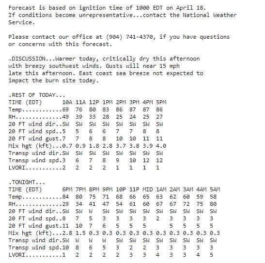
Florida Fire Weather Operating Plan – April 2020 Page 20Example: Morning Fire Weather Planning Forecast (FWF) Florida Fire Weather Operating Plan – April 2020 Page 21
Example: Afternoon Fire Weather Planning Forecast (FWF)

Florida Fire Weather Operating Plan – April 2020          Page 22
B. National Fire Danger Rating System (NFDRS) Forecast (FWM)

The National Fire Danger Rating System (NFDRS) measures wildland fire danger at
observation sites throughout the contiguous United States. The National Weather Service role
in NFDRS is forecasting weather input which, combined with user input, allows the NFDRS
software to predict the next day’s fire danger indices. These indices impact agency resource
management decisions, firefighter safety, and protection of the public and property.

NFDRS Forecast Content and Decode:

The National Fire Danger Ratings System (NFDRS) forecast (FWM) is a 24-hour site specific
digital forecast for numerous locations across the state (1300-1300 LST). NFDRS forecast
issuance times are dependent on the arrival of the observations in the FWO product.

   Format:
   FCST,081301,180418,13,0,85,27,1,1,SW,08,M,85,49,96,27,0,0,N           A,   B,       C,       D,
   WX,T,RH,LAL,TL,DD,FF,F,TX,TN,RX,RN,P1,P2,WF

   A. Indicates forecast is for NFDRS zone or individual station. FCST = station, ZONE =
      forecast zone (ex: FCST). Refers to federal observing sites: First two digits are state
      code (Florida 08), next two digits are USFS county ID, last two digits are site number.

   B. NFDRS Station Number or Zone Number (ex: 08301)

   C. Year, month, and day valid forecast time (ex: 180418)

   D. Always 1300 LST

   WX: State of weather 1300 tomorrow (ex: 0): State of weather - single digit, 0-9:
        1 Clear (less than 1/10 cloud cover)
        2 Scattered clouds (1/10 to 5/10)
        3 Broken clouds (6/10 to 9/10)
        4 Overcast (more than 9/10 clouds)
        5 Fog
        6 Drizzle
        7 Rain
        8 Snow or Sleet
        9 Showers
        10 Thunderstorm

   T: Temperature 1300 tomorrow in degrees Fahrenheit (ex: 85)
   RH: Relative humidity 1300 tomorrow in percent (ex: 27)

Florida Fire Weather Operating Plan – April 2020                                            Page 23
LAL: Lightning Activity Level 1400 LST to 2300 LST. Reference LAL definitions in previous section “Fire Weather Planning Forecast” TL: Lightning Activity Level 2300 LST to 2300 LST. DD: Wind direction 20 ft 1300 LST tomorrow (ex: SW) FF: Wind speed 20 ft 1300 LST tomorrow. In canopy, usually about 70% of zone forecast value (ex: 8) F: Fuel stick (not forecast). 10-hr time lag fuel moisture. Normally coded as M (missing) since computation is made by WIMS computer for DSPW and DSPI products (ex: M) TX: Max 24-hr temperature 1300 today to 1300 tomorrow, up to 136 ° F (ex: 85) TN: Min 24-hr temperature 1300 today to 1300 tomorrow, down to -100 ° F (ex: 49) RX: Max 24-hr humidity 1300 today to 1300 tomorrow (ex: 96) RN: Min 24-hr humidity 1300 today to 1300 tomorrow (ex: 27) P1: Precipitation duration in hours 1300 LST today through 0500 LST tomorrow. One or two digits in hours (00 to 08). Reserve for rain areal coverage of 70% or higher (ex: 0) P2: Precipitation duration 0500 LST through 1300 LST tomorrow (ex: 0) WF: Wet flag (Y/N). Indicates if liquid water will be on fuels at 1300 tomorrow. Reserve y for greater than 70% areal coverage of wetting rain in amounts greater than one tenth inch, otherwise y resets fire danger indices to zero. (ex: N) Florida Fire Weather Operating Plan – April 2020 Page 24
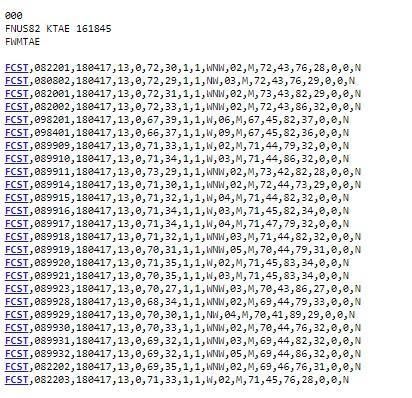
Example: NFDRS Planning Forecast (FWM)

Florida Fire Weather Operating Plan – April 2020   Page 25
C. Spot Forecast (FWS)

Site specific, spot forecasts, are issued by National Weather Service offices in support of
wildfire suppression and natural resource management. These forecasts help land
management and fire control agencies protect life and property during wildland fires and
prescribed burns. Spot forecasts are also utilized for hazardous materials incidents and other
potential threats to public safety influenced by weather.

The Spot Forecast is a non-routine, user requested product that includes a site specific forecast
for an incident. The product includes a headline, weather discussion focused on the next 12-24
hours, and an incremental tabular forecast.

Requesting a NWS SPOT Forecast

The National Weather Service will provide spot forecast support and service upon request of
any federal, state, tribal, or local official who represents that the spot forecast is required to
support a wildfire.

For non-wildfire purposes, the National Weather Service will provide spot forecast support
and service under the following circumstances and conditions:

   A. Upon the request of any federal official who represents that the spot forecast is required
      under the terms of the Interagency Agreement for Meteorological Services.

   B. Upon request of any state, tribal, or local official who represents that the spot forecast is
      required to carry out their wildland fire management responsibilities in coordination with
      any federal land management agency participating in the Interagency Agreement for
      Meteorological Services.

   C. Upon request of any public official who represents that the spot forecast is essential to
      public safety, e.g. due to the proximity of population centers or critical infrastructure. A
      “public safety official” is an employee or contract agent of a government agency at any
      level (federal, state, local, tribal, etc.) charged with protecting the public from hazards
      including wildland fires and/or other hazards influenced by weather conditions such as
      hazardous material releases.

   D. Upon request of any public official for natural resource protection and/or in support of
      https://www.dhs.gov/publication/homeland-security-presidentialdirective-5 related
      activities.

The Internet based NWS Spot program is used for requesting and issuing spot forecasts and
should be used when possible: www.weather.gov/spot

The spot forecast may be requested immediately or scheduled for a future date and time.

Florida Fire Weather Operating Plan – April 2020                                             Page 26
If Internet access is unavailable, spot forecasts may be requested and disseminated by telephone or
fax.
Spot forecasts should normally be available within 30 minutes of the requested deliver time with
typically no more than a 60 minute deadline. If the spot request is for wildfire, the forecaster
should assign a higher priority for forecast preparation. For the safety of fire crews and
operations, a spot request for wildfire will be prioritized similar to the expediency of severe
weather warnings.
The requesting agency can aid the forecaster by providing at a minimum the following
information:
1. Nature or reason of fire (wildfire or prescribed burn)
2. Name of fire
3. Name and phone number of control agency and/or representative
4. Location of the fire (latitude/longitude)
5. Size of fire or project (acres)
6. Recent weather observation near the fire site
The submission of at least one recent accurate weather observation from near the fire site is
encouraged with each spot forecast request. For prescribed burns, a planned ignition time is
recommended as well. Please include additional information which would help the forecaster
prioritize the request such as a threat to structures, the public, fire operations, or unusual fire
behavior.
User feedback is encouraged regarding the spot forecast to the NWS forecast office that issued
the product, preferably substantiated by on-site observations. If the forecast does not
reasonably match observed conditions, please call the forecast office and request to discuss
the situation and/or to request an updated spot forecast.
NWS Spot Forecast content:
The text Spot Forecast (FWS) product will contain the name of the incident, the issuing
National Weather Service Office, the time and date of spot forecast issuance and the following:
Headline: For watch/warning criteria weather discussion.
Weather parameters: For the first 12 hours will include a 1-2 hour time incremental breakup
of: sky, weather, chance of precipitation, temperature, RH, and 20 ft wind. Optional elements
may be forecast such as mixing height, transport winds, and atmospheric dispersion.
Outlook Forecast: Typically overnight with abbreviated weather information. Outlook for next
day typically with abbreviated weather information.
Florida Fire Weather Operating Plan – April 2020 Page 27Example: Spot Weather Forecast (FWS) Requesting Hysplit Model Run Government agencies may also request a Hysplit model run for chemical release and/or smoke dispersion. To request HYSPLIT forecast model trajectories from NWS Spot forecast request webpages, the authorized user must click on the box in the spot forecast request. The HYSPLIT trajectory raw data, as well as ".gif" (image) and ".kmz" (geocoded) files, will be sent to the specified email address. For more information concerning HYSPLIT: http://www.arl.noaa.gov/HYSPLIT_info.php Spot Forecast Agency Support (Florida Forest Service) Site specific spot forecasts are also available from the Florida Forest Service’s spot forecast web page. To process and receive automated spot forecasts access the internet address: http://spotweather.freshfromflorida.com/ Florida Fire Weather Operating Plan – April 2020 Page 28
D. Fire Weather Watch and/or Red Flag Warnings (RFW)

Fire Weather Watch and Red Flag Warning products inform land management agencies of
critical weather factors and fuel conditions that could support extreme fire danger and/or
behavior and thus threaten life and property. These products can alert to the potential for
widespread new ignitions or control problems with existing fires.

Weather and fuel definition for the issuance of a Red Flag Warning is coordinated in advance
with land management agencies and users within the state of Florida.

Critically dry fuels in Florida are highly dependent on one hour fuel moisture, which is directly
determined by the relative humidity; therefore, critically dry relative humidity is equivalent to
critically dry fuels.

Florida is divided into two geographic areas for Red Flag criteria; North Florida and
Peninsula Florida. North Florida includes all zones within the NWS Mobile, NWS
Tallahassee, and NWS Jacksonville service areas. The southernmost counties within ‘North
Florida’ include Dixie, Gilchrist, Alachua, Marion, Putnam, and Flagler. All areas south of these
counties are known as Peninsula Florida.

In coordination with land management agencies including the Florida Forest Service, U.S. Fish
and Wildlife, National Park Service, Bureau of Indian Affairs, and other federal, state or local
government agency with fire weather concerns, Red Flag events will be defined as the
following:

   North Florida Red Flag Criteria:
   Relative humidity < 28% and sustained 20-ft winds of > 15 mph occurring with
   Energy Release Components of ≥ 26 units.

   Peninsula Florida Flag Criteria:
   Relative humidity < 35% and sustained 20-ft winds of > 15 mph occurring with
   Energy Release Components of ≥ 27 units.

The Energy Release Component for each forecast zone is extracted from the Florida
Forest Service website: http://currentweather.freshfromflorida.com/fdi-report.html

NOTE: The Red Flag criteria is based on RH < 10th percentile and the ERC value < 25th
percentile. The percentiles were determined based on climatology and restricting the dataset to
the 90th percentile of fire activity by acreage burned for each region, yielding the worst weather
from the worst fires. This climatology will consist of at least 40 years of fire and weather data,
and will be reexamined periodically to ensure the proper breakpoints are being used.

Florida Fire Weather Operating Plan – April 2020                                            Page 29
Fire Weather Watch & Red Flag Warning Issuance

A Fire Weather Watch is issued when there is high confidence for a Red Flag event, usually
within the next 18-96 hours. A Fire Weather Watch is not issued within the first 12 hrs of
forecast issuance. Although it is desirable for a Fire Weather Watch to precede a Red Flag
Warning, as watch is not a prerequisite for a Red Flag Warning. A Fire Weather Watch will
remain in effect until the forecast office determines that either the Red Flag event will not occur
or that the Fire Weather Watch should be upgraded to a Red Flag Warning. A red flag warning
will be in effect until the warning is cancelled or expires.

When a Fire Weather Watch or Red Flag Warning is issued, the event shall be headlined in
subsequent NWS fire weather forecasts for the impacted zone, including the Fire Weather
Planning Forecast (FWF) and Spot Forecasts (FWS). The exception is headlines are omitted
from the NFDRS forecasts (FWM).

The RFW and Fire Weather Forecasts (FWF) will be updated when a Fire Weather Watch or
Red Flag Warning is issued or cancelled or if errors occurred in the product text.

If an unforeseen Red Flag conditions develop, a Red Flag Warning will be issued and an
updated Fire Weather Planning Forecast (FWF) with the appropriate headline should be
issued. Notify the impacted FFS and affected federal agency dispatch offices impacted by the
newly issued Red Flag Warning.

Fire Weather Watch & Red Flag Warning Content

The Fire Weather Watch and Red Flag Warning format will include segmented forecast
information, and may contain an overview section, for each zone or zone combination expected
to experience Red Flag conditions.

Overview: This section is optional. The overview will summarize the fire weather threat, onset
time, reason for Red Flag issuance and area affected.

Discussion: A brief, non-technical discussion of the expected fire weather event.

Segmented Forecast Information: Each segment will include the UCG and geographic
description of impacted zones and/or zone numbers, a headline describing the state of the Fire
Weather Watch or Red Flag Warning (either that the product was issued, cancelled, continued,
upgraded), the effective time of the event, the critical weather elements expected and a
description of the effective area. The order of the segments will be prioritized as watch/warning
cancellation, current warnings then current watches. If multiple headlines are needed for one
zone segment, the order of headlines will be 1) Watch/Warning Cancellations, 2) Current
Warnings, 3) Current Watches.

Bullet Content: The content of the RFW product will contain bullet format forecast information.
Content can include the affected areas, the timing of the weather impacts, weather element
forecast including winds and relative humidity, and ERC values.

Florida Fire Weather Operating Plan – April 2020                                            Page 30
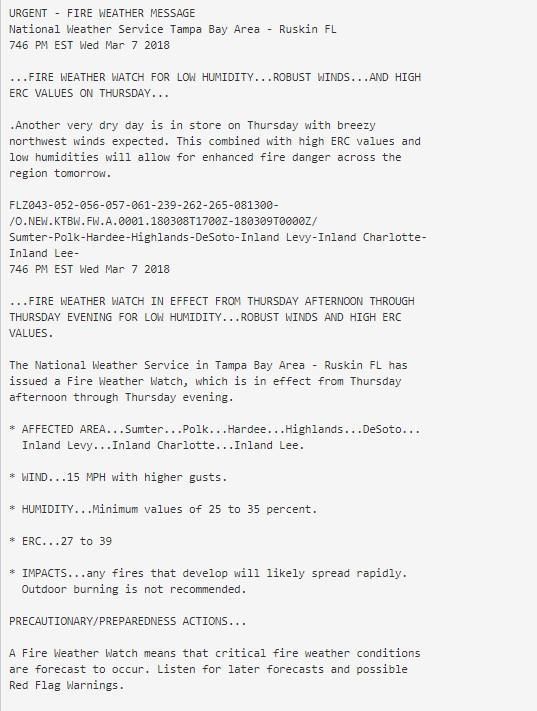
Fire Weather Watch Example

Florida Fire Weather Operating Plan – April 2020   Page 31
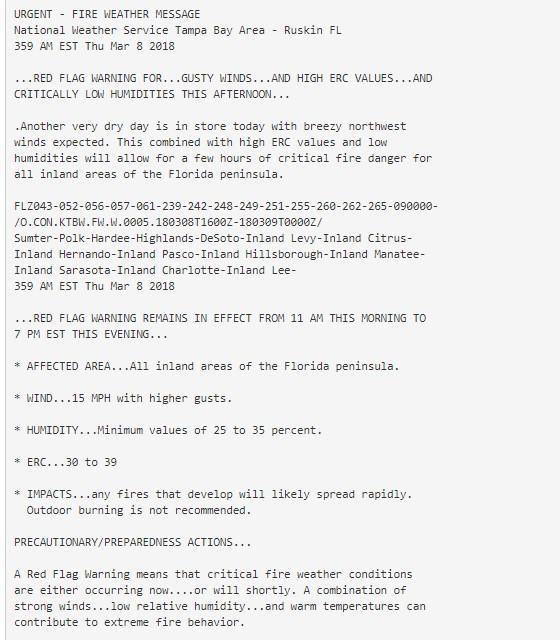
Red Flag Warning Example

Florida Fire Weather Operating Plan – April 2020   Page 32
E. On-Site NWS Support (NWS Directive 10-402)
   http://www.nws.noaa.gov/directives/sym/pd01004002curr.pdf

A qualified NWS Incident Meteorologist (IMET) may be present at expanding or large wildland
fire incidents. IMET deployments are dispatched through the NWS National Fire Weather
Operations Coordinator (NFWOC) at the National Interagency Fire Center (NIFC) in Boise, ID.
The IMET will work in support of the Fire Behavior Analyst, overall hazmat team and Incident
Commander under the National Incident Command System Structure.

IMETs travel with an All-Hazards Meteorological Response System (AMRS) kit that can be
used to gather weather intelligence to support the incident command team. Part of the AMRS
kit includes a fire weather laptop computer which is a national resource to support deployed
IMETs. IMET laptops have standardized software configuration that should not be modified.
Laptops utilize a windows operating system. All IMETs are responsible for the care and
transport of the laptops to and from incidents. While in possession of the laptop, the IMET
meteorologist is also responsible for checking the laptop PC and restocking any support
supplies, batteries, software, forms, etc. (to ensure dispatch readiness).

In Florida, NWS IMETs are located at NWS Jacksonville, NWS Tampa Bay-Ruskin, NWS
Melbourne, NWS Miami an NWS Key West.

User agencies will reimburse the NWS for all costs associated with IMET mobilizations set forth
in the National Agreement. Reimbursable expenses include overtime, per diem, travel,
equipment maintenance, and transportation of the IMET and equipment.

Requesting an IMET

A request for an IMET meteorologist should be placed through the Florida Interagency
Coordination Center (FICC) in Tallahassee. FICC will forward the request to appropriate
channels for IMET dispatch, day and night. The requesting agency is responsible for
coordinating transportation of the IMET to and from the incident site. Only a federal agency
may order an IMET for on-site support. IMETs can also be ordered for prescribed burns for
more complex operations (reference IMET_Rx_Annoucement_March2020 document). Should
the State of Florida, or a more local agency/county enter into an interagency agreement, the
services would then be provided as per the agreements.

IMETs are responsible for obtaining the following information upon dispatch:
      • Name of agency requesting support
      • Name and telephone number of person requesting support
      • Incident name and location
      • Resource order for the IMET
      • Directions to fire camp or incident location
      • Type of incident team including the Incident Commander, Planning section chief and
         Fire Behavior Analyst, or Hazmat Lead if available.

Florida Fire Weather Operating Plan – April 2020                                        Page 33
IMET Onsite Needs The user agency is responsible for providing adequate shelter for the IMET and the IMETs AMRS equipment to function efficiently. This includes a location free of excessive dust, heat and moisture, protection from wind and other elements, and a table and chair. The AMRS requires 120 volt AC power and the laptop needs quality Internet access. Charges to or from the incident should be charged to the incident. Coordination on Incidents The IMET and local NWS Weather Forecast Office (WFO) should coordinate at least daily basis. The local WFO will at least notify deployed IMETs of any significant weather threatening the fire site, including potential watches or warnings. If the IMET is located at an incident without phone communication, the WFO should notify the local dispatch office of potential critical weather conditions, and the dispatch office should then notify the incident and/or IMET. In cases of watch or warning issuances by the local WFO, the IMET should defer to the local office. However, in the absence of a watch or warning from the local WFO, the IMET has discretion to issue a Fire Weather Watch or Red Flag Warning for the incident only. The IMET will coordinate with the local WFO, or in the absence of time, will notify the local WFO of any such issuances as soon as is practicable. In instances of multiple IMETs dispatched within to a single WFO service area, the GACC Region and the NFWOC should coordinate and determine the necessity for regularly scheduled conference calls. If conference calls are considered necessary, the GACC Region should assist the WFO MIC in setting up the calls. The calls should include WFO forecasters, the deployed IMETs, and the NFWOC. Other nearby WFOs and any IMETs in that WFO’s service area may also be included in the call. IMET duties IMET deployments to an incident can vary and can range up to two weeks, but will not exceed 14 days onsite. The IMET serves within the incident management team, typically in concert with the Fire Behavior Analyst under the supervision of the Plans Section Chief. IMET duties include daily planning forecast coordination and composition, spot forecasts as requested, daily weather briefings, weather observations, weather records, daily log of duties and contacts, and ensuring the functionality of the AMRS equipment. The structure of each IMET forecast will vary depending on the weather needs of the incident management team. Florida Fire Weather Operating Plan – April 2020 Page 34
F. Other NWS Forecast Services & Products

Other Special Support Services

NWS fire weather meteorologists are available to assist land management agencies teaching
the weather units of fire training courses (S-190, S-290, RT-130, Florida Interagency
Prescribed Burn course, etc.) Requests for assistance should be made through the local NWS
fire weather program leader. Requests should be made as far in advance of the training dates
as possible to allow for scheduling. Ancillary expenses incurred by the NWS while providing
training should be reimbursed by the requesting agency.

Other meteorological services are available under the direction of the Interagency Agreement
for Meteorological Services. These include services include observation training, site visits,
course development work , training of weather observers and quality control of weather data.

Fire Weather Annual Report

Every WFO that issues non-routine fire weather products during their fire weather season (e.g.,
spot forecasts, Fire Weather Watches, Red Flag Warnings) will produce an annual report
summarizing fire support in their area of responsibility. WFOs should disseminate the Annual
Report to the same entities as the AOP. Annual Reports should summarize the calendar year
activities. NWS Regional Headquarters will determine the due date of the Annual Report, and
the regional statistics are due March 1st. For further guidance on annual fire activity reports
from the NWS, please refer to NWS Directive 10-404.

Conference Calls & Webinars:

During periods of intense or prolonged wildfire activity, conference calls may be organized
between land management agencies, state and federal emergency officials, state water
management districts, and the National Weather Service. Topics of discussion include current
drought and/or indices relating to drought, available surface and fuel moisture, wildfire activity,
status of control operations, public and property safety issues, preparedness actions, and the
outlook for future planning and logistics. Participating NWS offices may schedule routine web-
based conferences with partners in their areas especially during occurrences of critical fire
weather conditions

FARSITE Meteorological Data

Farsite is a fire behavior and growth simulator program used by Fire Behavior Analysts.
FARSITE is designed for use by trained, professional wildland fire planners and managers
familiar with fuels, weather, topography, wildfire situations.
ASCII formatted files containing daily summaries of temperature, relative humidity and
precipitation, and hourly data of wind speed, wind direction, and cloud cover are available from
participating WFO’s. The weather files can be used with FARSITE to predict the likely behavior
of a wildfire up to 72 hours into the future. Please contact your local WFO for more information
about FARSITE

Florida Fire Weather Operating Plan – April 2020                                             Page 35
Area Forecast Discussion

This is a NWS issued product where information on wildfire related weather effects may be
included. Typically issued up to four times daily, the product serves as an excellent forum for
coordinating meteorological reasoning among weather offices. Technical terms may be used,
but the brief discussion should focus on weather effects and not fire behavior. As a
coordination tool and ledger of ongoing NWS watch and warning issuance, use of the terms
Red Flag Warning and Fire Weather Watch is permitted.

Dense Smoke Advisory (NPW)

This product is issued by local NWS offices for persisting local or widespread dense smoke
reducing visibilities to ¼ mile or less over a portion or all of a forecast zone. Issuance of Dense
Smoke advisories are typically pre-coordinated with authorities (DOF, FHP and/or other law
enforcement authorities) who typically monitor the scope of smoke emissions in the area of
existing fires.

NWS Hazardous Weather Outlooks (HWO)

The NWS Hazardous Weather Outlook is a publicly disseminated discussion of any and all
potentially hazardous weather that may affect a NWS forecast area out through 7 days. Not all
Florida offices issue a HWO.

The HWO can relay weather information related to a fire/smoke threat to the public. The intent
is two-fold: to provide the public with a sufficient level of awareness as to minimize the
occurrence of accidental fire starts; and encourage a rapid and appropriate response should
fire threaten life and/or property.

Web and Email Briefings

Many NWS offices are transitioning to web-based and email-based briefings to alert partners of
potential weather impacts over the next 7 days. Please contact your local NWS office to learn
what briefing services they provide.

Civil Emergency Messages (CEM)

Special messages that contain information on events that would require protective actions on
the part of the public are transmitted by the NWS in conjunction with the Florida Division of
Emergency Management and Department of Homeland Security via the Internet and broadcast
on NOAA Weather Radio when requested by authorities.

Emergency situations requiring civil emergency messages may include wildfires threatening life
and property, including the health hazard of excessive dense smoke. Such messages may
include pending or ongoing evacuation orders.

Request and authentication of CEM messages would come from the office of the state of
Florida, Division of Emergency Management, or law/fire enforcement officials through the
Florida Fire Weather Operating Plan – April 2020                                            Page 36
ESATCOM, the state’s emergency communications system. Text of the requested CEM should
be faxed to the appropriate NWS office with receipt confirmed to the sender. CEM messages
should be same/tone alerted on NOAA weather radio.

Example of Civil Emergency Message (CEM)

BULLETIN-EAS ACTIVATION REQUESTED CIVIL EMERGENCY
MESSAGE NATIONAL WEATHER SERVICE TAMPA BAY AREA- RUSKIN FL
330 PM EST FRI MAR 19 2009

THE FOLLOWING MESSAGE IS BEING TRANSMITTED AT THE REQUEST OF THE LEE
COUNTY EMERGENCY MANAGEMENT OFFICE.

A WILDFIRE AT LEHIGH ACRES COUNTRY CLUB HAS CONSUMED SEVERAL
HUNDRED ACRES OF GRASS AND WAS SPREADING WEST TOWARD DENSELY
POPULATED AREAS OF EAST LEHIGH ACRES. STRONG WINDS FROM THE EAST
COUPLED WITH LOW HUMIDITY ARE EXPECTED TO PUSH WILDFIRES RAPIDLY WEST
ACROSS LEHIGH ACRES OVER THE NEXT 3 HOURS.

EMERGENCY MANAGEMENT OFFICIALS HAVE ORDERED A MANDATORY EVACUATION,
EFFECTIVE IMMEDIATELY, NORTH OF STATE ROAD 884 TO SOUTH OF 8TH AVENUE,
AND WEST TO THE ORANGE RIVER CANAL.

LISTEN TO NOAA WEATHER RADIO, LOCAL TELEVISION, OR RADIO FOR ADDITIONAL
INFORMATION ON THE LOCAL CIVIL EMERGENCY.

Florida Fire Weather Operating Plan – April 2020                                   Page 37
IV. Fire Agency Operational Support and Services

Florida Fire Weather Observations

Routine fire weather observations are meant to reflect the most volatile fire weather conditions
of the day, so observations are taken during the mid-afternoon near the average time of
maximum heating. Observations provide needed site weather information for forecast
issuances and the verification of prior forecasts. Observations and forecasts provide needed
weather input for land management decision making for operational planning, staffing, and the
issuance of burn permits. To provide input for the preparation of afternoon planning forecasts,
observations are taken daily at 2 pm eastern time (1pm central time).

Florida Forest Service Observations

Deadline for DOF observations to be available is 2:30 pm eastern time. The majority of the
observations are from Florida Forest Service district offices. Observations are accessible via
the internet at address: http://distweather.freshfromflorida.com/

The Florida Forest Service uses the Wildland Fire Danger Index (FDI) for estimating the
potential for a fire to start and require suppression action on any given day. The FDI does not
consider how quickly any fires that do start will grow due to prevailing winds.

For more information about this index please refer to the following link:
http://currentweather.freshfromflorida.com/fdi-report.html

Relaying Potential Severe Weather Reports to NWS

The National Weather Service requests significant weather reports from land management
agencies. The collection of timely, ground truth reports from reliable observers will always be of
critical importance to the weather forecaster and can greatly aid NWS meteorologists in their
warning decision making process. Delayed reports are also appreciated as they will be used to
verify warning events. Reports can be made anytime directly to National Weather Service
offices. When relaying a weather report to the NWS, give the location of the event, approximate
time of damage (if known), extent of damage, and the agency reporting the event. Significant
weather events to relay to the local NWS forecast office include:

•       Funnel clouds or tornadoes touchdown and waterspouts
•       Hail, especially when ½ inch or larger in diameter
•       Measured wind gusts > 50 mph
•       Uprooted trees, power lines down, structure damage from wind
•       Any weather related event with possible impact to life or property
•       Rainfall accumulation of 2 inches per hour or 4 inches per day
•       Weather that poses a potential threat to life and/or property

Florida Fire Weather Operating Plan – April 2020                                           Page 38
You can also read