GENERAL DATASET DESCRIPTION - LGSR Technical Series - UFSM
←
→
Page content transcription
If your browser does not render page correctly, please read the page content below
GENERAL DATASET DESCRIPTION
                                LGSR Technical Series

 Unmanned Aerial Vehicle (UAV) data acquired over a subtropical forest
 area of the UFSM campus Frederico Westphalen, on October 29, 2019, in
 the Rio Grande do Sul State, Brazil

OCT., 29 2019

LGSR/UFSM campus Frederico Westphalen
Author: Eduardo Riede, Geovani Sestari, & Fábio Marcelo Breunig

                           Frederico Westphalen, RS, Brazil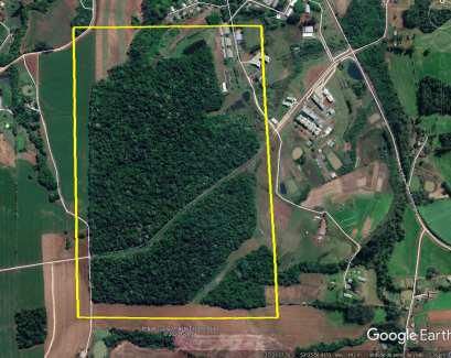
LGSR Tech. Series                                            GENERAL DATASET DESCRIPTION

         Eduardo Rieder¹ (author); Geovani Sestari¹ (author) & Fábio Marcelo Breunig¹ (author)
      ¹ Universidade Federal de Santa Maria, Departamento de Engenharia Florestal, Frederico
                   Westphalen, Rio Grande do Sul, Brasil. E-mail: breunig@ufsm.br

Title:
Unmanned Aerial Vehicle (UAV) data acquired over a subtropical forest area of the UFSM campus
Frederico Westphalen, on October 29, 2019, in the Rio Grande do Sul State, Brazil

Keywords
Images, Drone, UAV, Forest, UFSM, Remote Sensing, GIS.

Data description:
The data were acquired from an aerial survey conducted with an Unmanned Aerial Vehicle (UAV, also
Drone) covering a forest area of the Federal University of Santa Maria – UFSM in the municipality of
Frederico Westphalen, in the Rio Grande do Sul, Brazil (Figure 1). The climate of the region is subtropical
(Cfa in the Köppen-Geiger classification) with an average annual temperature of 18 °C and annual
precipitation of 1919 mm (Alvares et al., 2013). The rainfall is well distributed throughout the year.

Figure 1. Location of the site of data acquisition. Based on Google Earth Pro scenes. The KML and KMZ
are appended to the files.

                            Laboratory of GIS and Remote Sensing (LGSR/UFSM-FW)
                                                                                                        2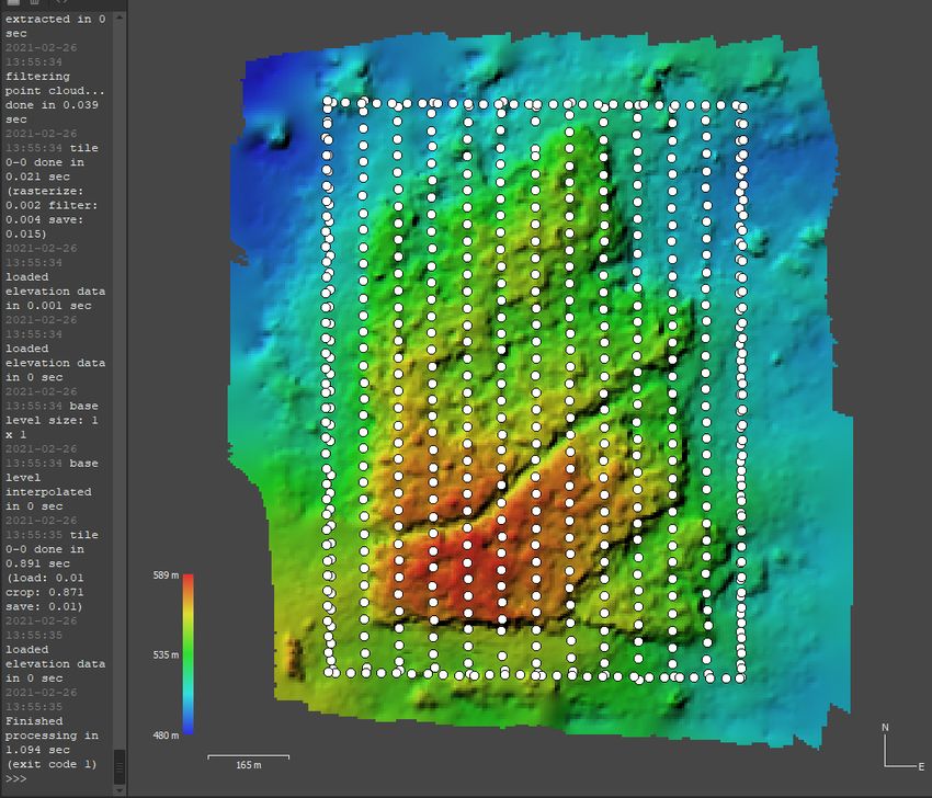
LGSR Tech. Series GENERAL DATASET DESCRIPTION
UAV and camera settings for the acquisition (Specifications Table):
Parameters Specification/value
Date (YYYYMMDD): 20191029
Time of day (BRT = -3) 12:00 h
UAV – Drone - Camera Phantom 4
Fly high (meters above ground) 200 m
View angle 90° automatic mode.
Sky conditions ( x ) Clear sky
( ) Low cloud coverage (some clouds)
( ) Completely cloudy
Wind condition ( x ) no wind
( ) Low speed
( ) High speed wind
Approximate data acquisition duration 30 minutes
Total of photographs acquired Sensor 1/2.3” CMOS
Effective pixels:12.4 M
Lens FOV 94° 20 mm (35 mm format
equivalent) f/2.8 focus at ∞
587 photos
Along track coverage 85%
Cross-track coverage 80%
Fly planning software Drone Deploy
For more information contact: Fábio Marcelo Breunig, breunig@ufsm.br
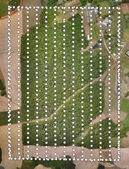
An example of the mosaic and DEM is showed below (Figure 2 e Figura 3), referring to a screen capture
of Agisoft Metashape (Agisoft LLC, 11 Degtyarniy per., St. Petersburg, Russia, 191144) and, the
workflow adopted.
Laboratory of GIS and Remote Sensing (LGSR/UFSM-FW)
3
LGSR Tech. Series                                          GENERAL DATASET DESCRIPTION

Figure 2. The capture of an orthomosaic in the processing workflow of the X3 camera. The lowest
quality was applied.

                          Laboratory of GIS and Remote Sensing (LGSR/UFSM-FW)
                                                                                                  4
LGSR Tech. Series                                             GENERAL DATASET DESCRIPTION

Figure 3. The capture of a DEM in the processing workflow of the X3 camera. The lowest quality was
applied.

References to the main project/publications:

Breunig, Fabio Marcelo. Combination of UAV, PlanetScope, Landsat, and Sentinel-2 images to
precision silviculture and agriculture in a subtropical region. Project. National Council for Scientific and
Technological Development (CNPq). Grant 305084/2020-8

Breunig, Fabio Marcelo. CONESAT – Monitoring the CONESUL using remote sensing data. Project.
Federal University of Santa Maria, Campus of Frederico Westphalen. Brazil. Available at:
.

                            Laboratory of GIS and Remote Sensing (LGSR/UFSM-FW)
                                                                                                         5
LGSR Tech. Series GENERAL DATASET DESCRIPTION
Breunig, Fabio Marcelo. Integration of multiscale remote sensing data in the precision agriculture and
silviculture (in Portuguese: Integração de dados multiescala de sensoriamento remoto na agricultura e
silvicultura de precisão). Project. National Council for Scientific and Technological Development
(CNPq). Grant 113769/2018-0
Breunig, Fabio Marcelo. Combination of UAV, PlanetScope, Landsat and Sentinel-2 images to
precision silviculture and agriculture in a subtropical region (in Portuguese: Combinação de imagens de
VANT, PlanetScope, Landsat e Sentinal-2 para a silvicultura e agricultura de precisão em uma região
subtropical). Project of the National Council for Scientific and Technological Development (CNPq).
Grant 305084/2020-8
Acknowledgments:
This work was supported by the National Council for Scientific and Technological Development
(CNPq) (Grants 113769/2018-0, 312081/2013-8, 478085/2013-3 and, 305084/2020-8) and Fundação de
Amparo à Pesquisa do Estado do Rio Grande do Sul (Grant 23830.388.22048.19092016).
Other considerations
PS. A pdf file is also attached with this description.
Declaration of Competing Interest
The author declares that he has no competing interests or personal relationships that have or could be
perceived to have influenced the work reported in this report.
References associated:
Alvares, Clayton Alcarde, José Luiz Stape, Paulo Cesar Sentelhas, José Leonardo De Moraes
Gonçalves, and Gerd Sparovek, ‘Köppen’s Climate Classification Map for Brazil’, Meteorologische
Zeitschrift, 22 (2013), 711–28
Fabio Marcelo Breunig, Eduardo Rieder, & Renato Souza Santos. (2021, February 24). Unmanned
Aerial Vehicle (UAV) data acquired over a subtropical forest area of the UFSM campus Frederico
Laboratory of GIS and Remote Sensing (LGSR/UFSM-FW)
6LGSR Tech. Series GENERAL DATASET DESCRIPTION
Westphalen, on October 22, 2020, Rio Grande do Sul, Brazil. Zenodo.
http://doi.org/10.5281/zenodo.4559718
Fabio Marcelo Breunig, & Eduardo Rieder. (2021, February 23). Unmanned Aerial Vehicle (UAV) data
acquired over a subtropical forest area of the UFSM campus Frederico Westphalen, on November
11, 2020, Rio Grande do Sul, Brazil. Zenodo. http://doi.org/10.5281/zenodo.4558044
Fabio Marcelo Breunig, & Eduardo Rieder. (2021, February 24). Unmanned Aerial Vehicle (UAV) data
acquired over a subtropical forest area of the UFSM campus Frederico Westphalen, on November 5,
2020, Rio Grande do Sul, Brazil. Zenodo. http://doi.org/10.5281/zenodo.4558265
Fabio Marcelo Breunig, & Eduardo Rieder. (2021). Unmanned Aerial Vehicle (UAV) data acquired
over a subtropical forest area of the UFSM campus Frederico Westphalen, on December 23, 2020,
Rio Grande do Sul, Brazil. Zenodo. http://doi.org/10.5281/zenodo.4557790
Fabio Marcelo Breunig, & Eduardo Rieder. (2021). Unmanned Aerial Vehicle (UAV) data acquired
over a subtropical forest area of the UFSM campus Frederico Westphalen, on February 18, 2021, Rio
Grande do Sul, Brazil [Data set]. Zenodo. http://doi.org/10.5281/zenodo.4557192
Breunig, Fábio Marcelo (2020, October 20). Unmanned Aerial Vehicle (UAV) data acquired over an
experimental area of the UFSM campus Frederico Westphalen, on October 20, 2020, in the Rio
Grande do Sul, Brazil. Zenodo. http://doi.org/10.5281/zenodo.4354331
Breunig, Fábio Marcelo (2017, July 11). Unmanned Aerial Vehicle (UAV) data acquired over a
subtropical forest area of the UFSM campus Frederico Westphalen, on July 11, 2017, Rio Grande do
Sul, Brazil. Zenodo. http://doi.org/10.5281/zenodo.4328340
Breunig, Fábio Marcelo (2017, July 7). Unmanned Aerial Vehicle (UAV) data acquired over a
subtropical forest area of the UFSM campus Frederico Westphalen, on July 7, 2017, in the Rio
Grande do Sul, Brazil. Zenodo. http://doi.org/10.5281/zenodo.4327943
Breunig, Fábio Marcelo (2019): UAV images acquired over the UFSM campus in Frederico
Westphalen, RS, Brazil. Universidade Federal de Santa Maria, PANGAEA,
https://doi.org/10.1594/PANGAEA.897548
Laboratory of GIS and Remote Sensing (LGSR/UFSM-FW)
7LGSR Tech. Series GENERAL DATASET DESCRIPTION
Breunig, Fábio Marcelo (2019): UAV derived orthomosaic over the “prainha” in the municipality of
Iraí, Rio Grande do Sul, Brazil. Universidade Federal de Santa Maria, PANGAEA,
https://doi.org/10.1594/PANGAEA.897909
Breunig, Fábio Marcelo, Rafaelo Balbinot, Rafael Vendruscolo, and Renato Beppler Spohr, ‘Situação
Ambiental Do Campus Da UFSM de Frederico Westphalen, RS’, in Anais XVI Simpósio Brasileiro
de Sensoriamento Remoto - SBSR, ed. by Instituto Nacional De Pesquisas Espaciais - INPE (Foz do
Iguaçu - PR, Brazil: INPE, 2013), pp. 7241–48
Bertani, Gabriel, Fabio Marcelo Breunig, and Renato Beppler Sphor, ‘Análise de crescimento da
mancha urbana do município de Frederico Westphalen, RS-Brasil através de imagens Landsat 5
TM’, Revista Geografar, 7 (2012), 68–83
Rex, Franciel Eduardo, Pâmela Suélen Käfer, Fábio Marcelo Breunig, and Renato Beppler Spohr
Renato Souza Santos, ‘CLASSIFICAÇÃO SUPERVISIONADA DE COPAS DE ÁRVORES EM
IMAGEM DE ALTA RESOLUÇÃO ESPACIAL’, BIOFIX Scientific Journal, 3 (2018), 216–23
Eduardo Rieder, Renato Souza Santos, & Fabio Marcelo Breunig. (2021, February 26). Unmanned
Aerial Vehicle (UAV) data acquired over a subtropical forest area of the UFSM campus Frederico
Westphalen, on December 2, 2019, Rio Grande do Sul, Brazil. Zenodo.
http://doi.org/10.5281/zenodo.4560622
Eduardo Rieder, & Fabio Marcelo Breunig. (2021, February 26). Unmanned Aerial Vehicle (UAV) data
acquired over a subtropical forest area of the UFSM campus Frederico Westphalen, on November 1,
2019, Rio Grande do Sul, Brazil. Zenodo. PDF. http://doi.org/10.5281/zenodo.4564677
Sestari, Geovane (2019): RPAS orthomosaic over a remnant of rainforest on UFSM/IFFar campus in
the municipality of Frederico Westphalen, Rio Grande do Sul, Brazil. PANGAEA,
https://doi.org/10.1594/PANGAEA.910114
Laboratory of GIS and Remote Sensing (LGSR/UFSM-FW)
8LGSR Tech. Series GENERAL DATASET DESCRIPTION
ORCID
Eduardo Rieder: https://orcid.org/0000-0003-3572-4941
Geovani Sestari: https://orcid.org/0000-0002-5516-6548
Fábio Marcelo Breunig: https://orcid.org/0000-0002-0405-9603
Laboratory of GIS and Remote Sensing (LGSR/UFSM-FW)
9You can also read