GEOARCHAEOLOGICAL EVIDENCE OF THE AD 1642 YELLOW RIVER FLOOD THAT DESTROYED KAIFENG, A FORMER CAPITAL OF DYNASTIC CHINA - MPG.PURE
←
→
Page content transcription
If your browser does not render page correctly, please read the page content below
www.nature.com/scientificreports

            OPEN           Geoarchaeological evidence of the
                           AD 1642 Yellow River flood that
                           destroyed Kaifeng, a former capital
                           of dynastic China
                           Michael Storozum1,2,3*, Peng Lu4*, Sanying Wang5*, Panpan Chen4, Ruixia Yang6, Qifeng Ge5,
                           Jinping Cao5, Junwei Wan5, Hui Wang7, Zhen Qin8, Haiwang Liu9 & Edward Park10,11
                           Rising global temperatures will increase the number of extreme weather events, creating new
                           challenges for cities around the world. Archaeological research on the destruction and subsequent
                           reoccupation of ancient cities has the potential to reveal geological and social dynamics that have
                           historically contributed to making urban settings resilient to these extreme weather events. Using
                           a combination of archaeological and geological methods, we examine how extreme flood events at
                           Kaifeng, a former capital of dynastic China, have shaped the city’s urban resilience. Specifically, we
                           focus on an extreme Yellow River flood event in AD 1642 that historical records suggest killed around
                           300,000 people living in Kaifeng. Our recent archaeological excavations have discovered compelling
                           geological and archaeological evidence that corroborates these documents, revealing that the AD 1642
                           Yellow River flood destroyed Kaifeng’s inner city, entombing the city and its inhabitants within meters
                           of silt and clay. We argue that the AD 1642 flood was extraordinarily catastrophic because Kaifeng’s
                           city walls only partly collapsed, entrapping most of the flood waters within the city. Both the geology
                           of the Yellow River floods as well as the socio-political context of Kaifeng shaped the city’s resilience to
                           extreme flood events.

                           As cities face growing environmental uncertainties brought on by human-induced climate change, scientists are
                           becoming increasingly interested in the factors that make cities resilient to natural hazards1–3. Scientific studies
                           on the sedimentary and archaeological records found underneath modern cities have the potential to reveal the
                           geomorphic and social dynamics that have contributed to creating resilient urban environments4,5. In particular,
                           archaeological layers found underneath modern cities near rivers can contain evidence of extreme flood events
                           that are often outside the available range of instrumental records6–8. China’s Yellow River is a particularly fruitful
                           context for this kind of research because of China’s long recorded history of Yellow River flood events and abun-
                           dant archaeological remains. According to historical sources, the Yellow River has flooded over 1000 times in
                           the past 2000 years, claiming millions of lives9–11. Recent archaeological and geological field work has found the
                           physical evidence of several of these historically recorded flood events, but none of these studies have yet exam-
                           ined the influence catastrophic Yellow River flood events have had on shaping the resilience of large cities in the
                           Yellow River’s floodplain12–14.

                           1
                             Institute of Archaeological Science, Fudan University, Shanghai, 200433, P.R. China. 2Department of Cultural
                           Heritage and Museology, Fudan University, Shanghai, 200433, P.R. China. 3Department of Archaeology, Max Planck
                           Institute for the Science of Human History, Jena, 07745, Germany. 4Institute of Geography, Henan Academy of
                           Sciences, Zhengzhou, 450052, P.R. China. 5Kaifeng Institute of Archaeology and Cultural Relics, Kaifeng, 475000,
                           P.R. China. 6International Center on Space Technologies for Natural and Cultural Heritage Under the Auspices of
                           UNESCO, Beijing, 100094, P.R. China. 7Institute of Archaeology, Chinese Academy of Social Sciences, Beijing,
                           100710, P.R. China. 8School of History and Culture, Henan University, Kaifeng, 475001, P.R. China. 9Henan Provincial
                           Institute of Cultural Relics and Archaeology, Zhengzhou, 450000, P.R. China. 10National Institute of Education,
                           Nanyang Technological University, Singapore, 639798, Singapore. 11Asian School of the Environment, Nanyang
                           Technological University, Singapore, 639798, Singapore. *email: mjstorozum@fudan.edu.cn; bulate_0@163.com;
                           125615966@qq.com

Scientific Reports |   (2020) 10:3765 | https://doi.org/10.1038/s41598-020-60169-1                                                             1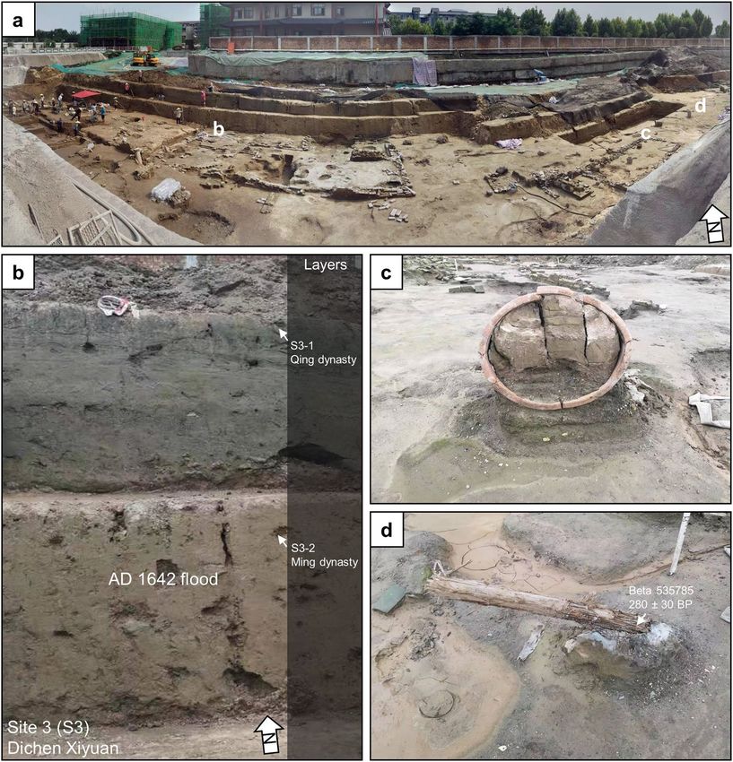
www.nature.com/scientificreports/ www.nature.com/scientificreports
Figure 1. Kaifeng and the Yellow River. (a) Topography of the North China Plain. (b) SRTM 90 m DEM of the
area around Kaifeng, note that the elevation of the Yellow River is higher than Kaifeng (Data available from the
U.S. Geological Survey). (d) The city walls of Kaifeng (solid line is the Song dynasty wall, dashed line is the Ming
/Qing dynasty wall) and sample locations Xinzhengmen (S1), Yongning Wangfu (S2), Dichen Xiyuan (S3),
Xinjiekou (S4), and Yulongwan (S5) (Imagery from Google Earth Pro, Digital Globe). (d) The super elevated
channel of the Yellow River hanging above Kaifeng, with the tallest building in medieval Kaifeng, the Iron
Pagoda, for scale.
Kaifeng was one of the largest cities in the world, the imperial capital of several Chinese dynasties, and also
an epicenter for Yellow River flood events (Fig. 1a–d). Despite Kaifeng’s political and economic importance, the
Yellow River has flooded Kaifeng around 40 times over the past 3000 years. These frequent floods have left behind
meters of alluvium mixed with urban debris, creating a 20 m thick archaeological sequence that dates from the
Bronze Age (ca. 2000 BC) to the Qing dynasty (AD 1644–1912) (Supplementary Table 1). However, only one of
these floods was powerful enough to destroy the entire city. According to The Veritable Documents of the Ming,
in AD 1642 a large army breached the dikes along the Yellow River to intentionally flood the city, killing nearly
300,000 people15. Kaifeng’s archaeological record contains ample evidence of urban destruction and renewal as a
result of this flood event and many others, making it an ideal location to start to examine the geological and social
components of urban resilience in relation to the Yellow River16–18.
Recent archaeological work at Kaifeng has unearthed compelling archaeological and sedimentary evidence
that corroborates the historical record of the exceptionally destructive AD 1642 Yellow River flood and other
historically documented flood events. In this paper, we present archaeological evidence, radiocarbon dates, and
geological data from excavations at excavations at Xinzhengmen, one of the western gates of the Song dynasty
(AD 960-1128) city, and several Ming dynasty (AD 1368-1642) “princely houses” known as Wangfu, to provide
insights into the social and natural factors that contributed to both the destruction and subsequent recovery of
Kaifeng after this devastating flood event.
Results
Since the 1980s’, the Kaifeng Institute of Archaeology and Cultural Relics has conducted numerous salvage exca-
vations throughout the municipal area of Kaifeng (see Supplementary Information). We have gathered strati-
graphic, radiocarbon, and archaeological evidence that strongly supports the historical descriptions of the AD
1642 Yellow River flood from five recently excavated locations: Xinzhengmen, Yongning Wangfu, Dichen Xiyuan,
Xinjiekou, and Yulongwan (see Fig. 1c, Table 1, and Supplementary Table 2).
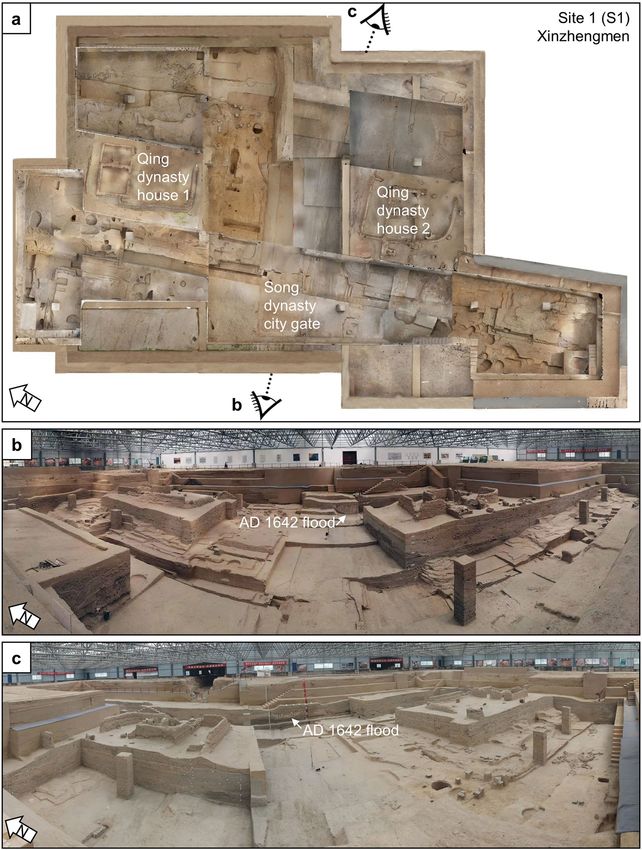
Xinzhengmen (S1). At Xinzhengmen, archaeologists have opened up a 2,100 m2 excavation area, uncover-
ing many architectural features that date to the Song, Yuan, Ming, and Qing dynasties18 (Fig. 2a). Two sections,
one in the north and one in the south, were excavated down to the Qing dynasty land surface, while the rest of the
excavation exposes the Song dynasty land surface. The trench is approximately 8 m deep and contains the remains
of the Song dynasty city wall and gate (Fig. 2b). The foundations of the Song dynasty city wall are 23 m wide and
Scientific Reports | (2020) 10:3765 | https://doi.org/10.1038/s41598-020-60169-1 2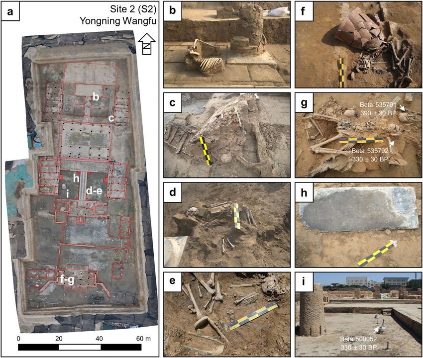
www.nature.com/scientificreports/                                                                                   www.nature.com/scientificreports

                                                                                                                      Calibrated years   Calibrated       Probability
     Site and layer           Material           Lab #         Context                        14
                                                                                                   C years   δ13C     AD (2σ)            years BP (2σ)    (%)
                                                               Context G3,
                                                                                                                      6057-5977 BC       8006-7926        83.4
     Xinzhengmen* (S1-7)      Organic sediment   Beta 535782   flood channel,                 7120 ± 30      −24.8
                                                                                                                      5947-5921 BC       7896-7870        12.0
                                                               67 m amsl
                                                               Context L14,
     Xinzhengmen (S1-8)       Charcoal           Beta 535781                                  950 ± 30       −24.5    1024-1155          926-795          95.4
                                                               66.1 m amsl
                                                                                                                      1735-1806          215-144          46.2
                                                               Context H231,
     Xinzhengmen (S1-6)       Charcoal           Beta 535783                                  220 ± 30       −25.1    1642-1684          308-266          37.9
                                                               68.5 m amsl
                                                                                                                      1933-post 1950     17 – post 0 BP   11.3
                                                                                                                      1798-1894          152-56           42.4
                                                               Buried tree, bark, found
     Xinzhengmen (S1-3)       Wood               Beta 500051                                  130 ± 30       −21.8    1674-1778          276-172          38
                                                               within AD 1841 flood deposit
                                                                                                                      1905-1942          45-8             14.9
                                                                                                                      1440-1524          510-426          69.2
     Yongning Wangfu (S2-4)   Tooth collagen     Beta 535791   T15, F9, #86                   390 ± 30       −17.6    1571-1630          379-320          25.7
                                                                                                                      1559-1562          391-388          0.5
     Yongning Wangfu (S2-4)   Tooth collagen     Beta 535792   T15:2, F9, #92                 330 ± 30       −18.1    1477-1642          473-308          95.4
                                                               Buried tree, bark, found
     Yongning Wangfu (S2-4)   Wood               Beta 500052                                  340 ± 30       −23.9    1470-1640          480-310          95.4
                                                               within AD 1642 flood deposit
                                                                                                                      1512-1600          438-350          54.3
                                                               Buried tree, bark, found                               1616-1666          334-284          38.3
     Dichen Xiyuan (S3-2)     Wood               Beta 535785                                  280 ± 30       −21.9
                                                               within AD 1642 flood deposit                           1784-1795          166-155          2.1
                                                                                                                      1498-1502          452-448          0.6
     Yulongwan (S5-3)         Tooth collagen     Beta 535789   T1:2, Jian 6                   340 ± 30       −15.2    1470-1640          480-310          95.4
     Yulongwan (S5-3)         Tooth collagen     Beta 535790   T2, F1, Jian 11                330 ± 30       −13.8    1477-1642          473-308          95.4

                                   Table 1. Accelerator mass spectrometry radiocarbon dates from Xinzhengmen, Yongning Wangfu, Yulongwan,
                                   and Dichen Xiyuan. Dates for each site are presented from oldest to youngest. The * indicates the date is
                                   anomalous. Dates are calibrated with BetaCal 3.21 using the IntCal13 dataset.

                                   are composed of rammed earth. The northern and southern sections of the excavation are about 4 m deep and
                                   contain evidence of several Qing dynasty house compounds buried by a Yellow River flood in AD 1841. Most of
                                   the exposed stratigraphy dates to the Ming dynasty occupation of the city, which itself contains a flood deposit
                                   that incised through many Ming dynasty strata (Fig. 2c). According to the ceramics found within these strata,
                                   archaeologists date this incised flood deposit to the AD 1642 Yellow River flood event.
                                       We collected three radiocarbon samples from the eastern profile to determine the age of these flood deposits
                                   (Fig. 2c, Supplementary Fig. 1, and Table 1). We constrained the chronology of the incised channel by collecting
                                   two samples, one from below and one from above the incised channel, to provide a terminus post quem and a
                                   terminus ante quem for the flood deposit (Fig. 3a). The sample (Beta 53781) located directly beneath the incised
                                   flood channel returned a date of 950 ± 30 BP, which calibrated to AD 1024-1155 (95.4%) (Supplementary Fig. 2a).
                                   The second sample, 1.5 m above the incised flood deposit (Beta 535783), returned a date of 220 ± 30 BP, which
                                   calibrated to AD 1735-1806 (46.2%), AD 1642-1854 (37.9%), and AD 1933-post 1950 (11.3%) (Supplementary
                                   Fig. 2b,3a). Subsequent calibration of the first pair of dates at Xinzhengmen constrained the age of the flood
                                   deposit, making it highly likely that this incised flood deposit is part of the AD 1642 Yellow River flood event. A
                                   third sample (Beta 500051) from Xinzhengmen was collected from a buried tree found within the AD 1841 flood
                                   deposit and returned at date of 130 ± 30 BP, which calibrates to AD 1798-1894 (42.4%), AD 1674-1778 (38.0%),
                                   AD 1905-1942 (14.9%) (Supplementary Fig. 3b).
                                       The excavations at Xinzhengmen have revealed a near continuous record of sedimentation from the Song to
                                   the Qing dynasties (Fig. 3a,b). Based on the radiocarbon and ceramic evidence, the stratigraphy contains depos-
                                   its from the historically recorded Yellow River floods of AD 1642 and AD 1841. According to the particle size
                                   data collected from the eastern profile, the sediments from the Song dynasty and the Qing dynasty occupation
                                   layers are sandy loams that have higher magnetic susceptibilities than both the AD 1642 and AD 1841 Yellow
                                   River flood deposits (Fig. 3b). The AD 1642 Yellow River flood deposit is composed of two parts, a reddish
                                   silt-filled channel and an underlying sandy layer, presumably the channel’s bedload. Both parts of the AD 1642
                                   flood deposit cleanly incised through cultural deposits, including cobble roads, bricks, and pottery, which pro-
                                   vides a relative sense for the power of this flood event (Supplementary Fig. 4a,b). Around 2 m above the AD 1642
                                   incised flood deposit is a 3 m thick sandy loam deposit that corresponds to the AD 1841 Yellow River flood. This
                                   flood deposit cleanly overlies the early Qing dynasty archaeological deposits at Xinzhengmen. This flood deposit
                                   contain many laminated beds that likely represent episodic flooding that occurred over many months, corrobo-
                                   rating descriptions of the AD 1841 flood found in historical documents19,20.

                                   Yongning Wangfu (S2). At Yongning Wangfu, archaeologists excavated around 4,000 m2 to reveal the lay-
                                   out of a palatal compound where they found over 1,000 sets of porcelain and copperware, as well as stone tablets
                                   inscribed with family lineages and reign dates (Fig. 4a, Supplementary FigS. 5–7). Here, archaeologists have also
                                   found 15 skeletonized individuals that perished before or during the AD 1642 flood (Fig. 4b–g). Most of the
                                   human remains are highly fragmentary and disarticulated. The individuals that were articulated or partially artic-
                                   ulated were found in a variety of positions, including both prone and supine with flexed limbs. Two individuals
                                   were found within wooden coffins and are presumed to have deceased before the AD 1642 flood. Aside from the
                                   human remains found within coffins, all the other skeletonized individuals appear to have died violently in the

Scientific Reports |          (2020) 10:3765 | https://doi.org/10.1038/s41598-020-60169-1                                                                               3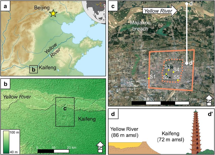
www.nature.com/scientificreports/                                                              www.nature.com/scientificreports

                           Figure 2. Xinzhengmen. (a) Plan view of of Xinzhenmen with panoramas taken from locations (b,c). (b) View
                           to the east. (c) View to the west.

                           flood, disarticulated by debris and then buried within the mud left behind from the flood waters. These individ-
                           uals are overlain by debris found within the flood deposit, including a wooden beam that appears to have pene-
                           trated an individual’s cranium and a large clay vessel which intrudes into another individual’s abdomen (Fig. 4f,g).
                           Several meters above the AD 1642 flood deposit, archaeologists found a stela inscribed with the date of the 34th
                           year of the Kangxi emperors’ reign, or AD 1695, indicating that people reoccupied the city around 50 years after
                           the AD 1642 flood (Fig. 4h, see Supplementary Fig. 8b).
                               At Yongning Wangfu, we have obtained three radiocarbon dates, one of which comes from a wooden column
                           and the other two dates are from skeletonized individuals disarticulated by flood debris (Supplementary Fig. 9a,b,

Scientific Reports |   (2020) 10:3765 | https://doi.org/10.1038/s41598-020-60169-1                                                           4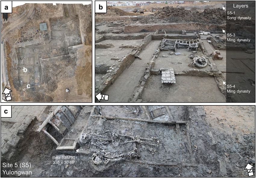
www.nature.com/scientificreports/                                                              www.nature.com/scientificreports

                           Figure 3. Stratigraphy at Xinzhengmen. (a) Sedimentary sequence including the incised deposit of the
                           AD 1642 Yellow River flood and the overlying AD 1841 Yellow River flood, the red circles are placed at the
                           approximate depths of samples for radiocarbon dating, see Supplementary Information for more details (b),
                           data for particle size, loss on ignition, and magnetic susceptibility every 5 cm.

                           Table 1). One individual (Beta 535791) returned a radiocarbon date of 390 ± 30 BP, calibrated to 1440–1524 (69.2%),
                           1571–1630 (25.7%), 1559–1562 (0.5%), roughly corresponding with the AD 1642 flood event and the other individ-
                           ual (Beta 535792) returned a radiocarbon age of 330 ± 30 BP, calibrated to 1477–1642 (95.4%) (Fig. 4g). The wood
                           sample (Beta 500052) returned a date of 340 ± 30 BP, calibrated to AD 1470–1640 (95.4%) (Fig. 4i).
                               The stratigraphy at Yongning Wangfu reveals that the AD 1642 Yellow River flood deposit is approximately
                           3 m thick and is primarily composed of silt loam (Fig. 5a–c, Supplementary Fig. 10). This profile contains strati-
                           graphic evidence of the destructive power of the AD 1642 Yellow River flood as well as cultural layers that date to
                           the reoccupation of the city during the early Qing dynasty. Large silt and sand “rip-up” clasts show that the flood
                           was extremely turbid and that the mudbrick buildings dissolved into the otherwise clayey matrix of the Yellow
                           River flood deposit (Fig. 5c). According to our particle size data, the flood deposit becomes less sandy up column,
                           probably a result of the general reduction of the flood’s energy (Fig. 5d). As the flood lost energy, it deposited a
                           reddish silt loam, typical of Yellow River flood deposits found nearby14,21. The flood deposits are clearly seen in
                           the profiles exposed during the excavations at Yongning Wangfu. The high magnetic susceptibility values found
                           in the Qing dynasty layer corroborates the archaeological evidence for a rapid reoccupation of Kaifeng after its
                           destruction in AD 1642.

                           Dichen Xiyuan (S3).          At Dichen Xiyuan, archaeologists opened up a 3,700 m2 rescue excavation. Here,
                           archaeologists found a large concentration of Ming dynasty buildings with pottery, porcelain and the remains
                           of a large kiln (Fig. 6a–c, Supplementary Fig. 11a–c). Judging from the layout of the buildings, the site may be
                           the western part of the Zhou Wangfu. We collected a piece of bark from a buried tree in a courtyard of a building
                           for radiocarbon dating and the sample (Beta 535785) returned a date of 280 ± 30 BP, which calibrates to AD
                           1512–1600 (54.3%), AD 1616–1666 (38.3%), AD 1784–1795 (2.1%), and AD 1498–1502 (0.6%) (Fig. 6d, Table 1).

                           Xinjiekou (S4).       At Xinjiekou, archaeologists conducted rescue excavations and uncovered over 400 m2 of
                           the former location of the Dianyi Suo (Office of the Rites), which was destroyed in the AD 1642 flood22. The
                           archaeologists found artifacts that date to the late Ming through the late Qing dynasties, including a Ming dynasty
                           courtyard that had collapsed houses and walls (Fig. 7a–c). Many artifacts were excavated from the site, includ-
                           ing lacquered wooden wares, porcelain, pottery and other daily utensils. Within the courtyard, archaeologists
                           unearthed a wooden plaque inscribed with the date of the tenth year of Emperor Chongzhen’s reign (AD 1637),
                           providing a reliable chronological anchor for the site (see Supplementary Information).

                           Yulongwan (S5).         At Yulongwan, archaeologists opened up an area of 970 m2 as part of a rescue excavation
                           (Fig. 8a). The archaeologists found three buildings that date to the late Ming dynasty which contained over 3,000
                           artifacts (Fig. 8b). Many of these artifacts are coins that were cast during the late Ming dynasty. Archaeologists

Scientific Reports |   (2020) 10:3765 | https://doi.org/10.1038/s41598-020-60169-1                                                           5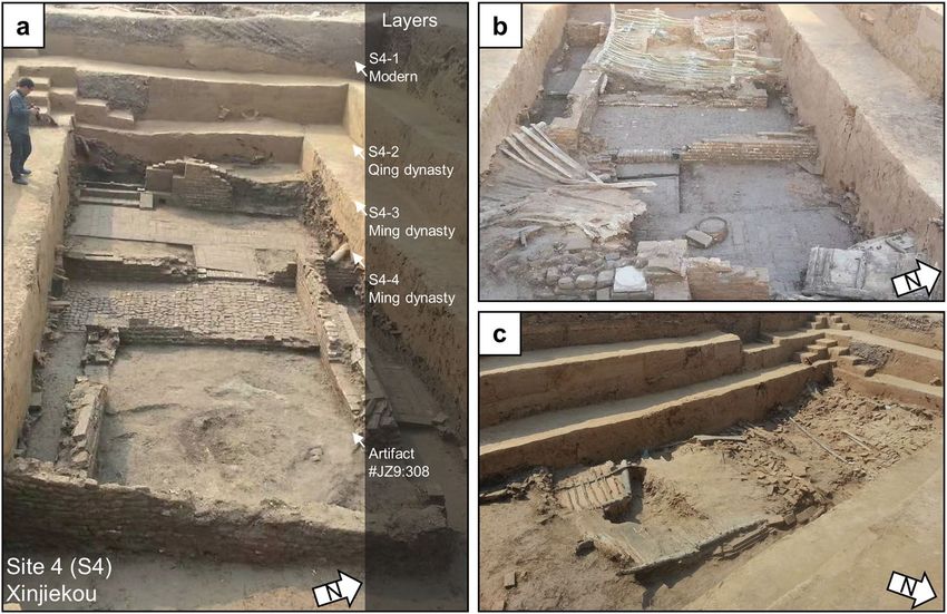
www.nature.com/scientificreports/                                                               www.nature.com/scientificreports

                           Figure 4. Yongning Wangfu. (a) Plan view of excavations at Yongning Wangfu with locations of AD 1642 flood
                           victims and chronological information marked. (b–g) Victims of the AD 1642 flood. (h) Stelae dating to AD
                           1695 found in reoccupation layer. (i) Wood column sampled for radiocarbon dating.

                           also found 11 skeletonized individuals, four of which were badly disarticulated, likely a result of a violent death in
                           the AD 1642 flood. Among these individuals, two were found prone on a wooden bedframe (Fig. 8c). We sampled
                           two individuals found at the site for radiocarbon dating (Table 1). One individual (Beta 535789) returned an age
                           of 340 ± 30 BP, which calibrates to AD 1470-1640 (95.4%), and another (Beta 535790) returned a radiocarbon age
                           of 330 ± 330 BP, which calibrates to AD 1477-1642 (95.4%), supporting the chronology provided by the material
                           evidence found at the site (Fig. 8c).

                           Discussion
                           Recent excavations of Kaifeng’s archaeological record are already revealing a unique dataset that is useful for
                           understanding the many geological and social factors that compose urban resilience in relation to the Yellow
                           River flood events. Taken together, the archaeological, historical, and sedimentary data recovered from Kaifeng
                           provide enough information to tentatively reconstruct the fluvial dynamics of the AD 1642 flood using paleo-
                           hydraulic methods (Fig. 9a). According to the historical records, the levee was breached somewhere around
                           modern-day Majiakou village, about 10 km to the north of Kaifeng15. After the levee was breached, we estimate
                           that the river’s water level dropped somewhere between 10 m to 15 m. We argue that these dropdown rates are
                           accurate given that the Yellow River’s average depth is around 35 m near Kaifeng, which we estimated from the
                           width to depth ratio of anabranching rivers found in climatic conditions similar to the Yellow River. Using Walder
                           & O’Connor’s hydraulic equation to estimate the coefficients necessary to model the peak discharge of flash flood
                           events as function of the drop in water level, we calculated that the flood’s peak discharge would be 360 m3 s−1 or
                           725 m3 s−1, given a 10 m or 15 m of drop in water level, respectively23.
                               Depending on the drop in water level, our values account for 32% or 64% of the river’s total discharge,
                           meaning that a significant percentage of the Yellow River’s total discharge was diverted directly into the city
                           almost immediately after the levee breach. Assuming the length of the breached dike is around 20 m, our rough
                           estimate for the river’s velocity during peak discharge is around 3.6 m s−1 or 5.9 m s−1, a comparatively fast flow
                           for a river in a lowland environment. This high flow velocity enabled the Yellow River to entrain objects as large
                           as a meter in diameter, assuming a 15 m drop in water level24. The fast moving Yellow River, and the large objects
                           the flood carried, could effectively scour through Kaifeng’s protective walls and gates, enabling the floodwaters
                           to enter the city.

Scientific Reports |   (2020) 10:3765 | https://doi.org/10.1038/s41598-020-60169-1                                                             6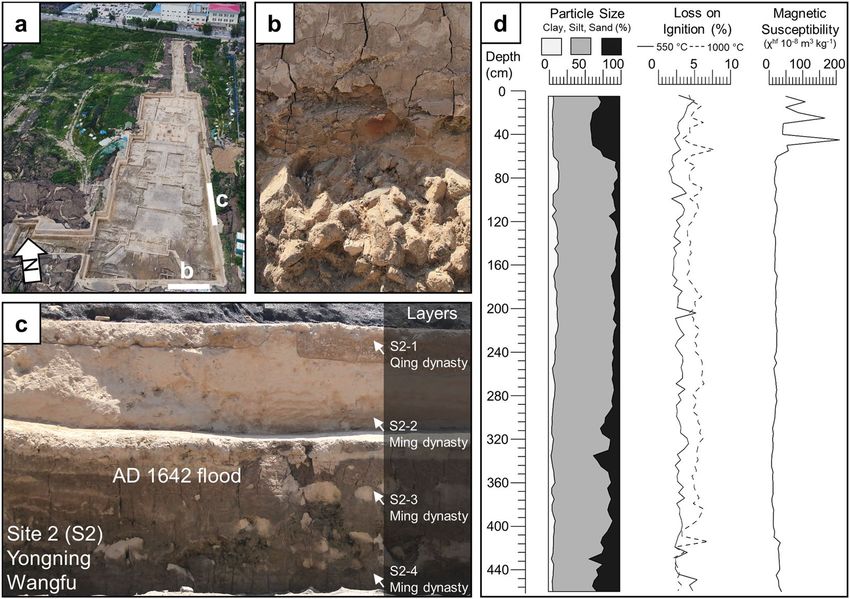
www.nature.com/scientificreports/                                                                 www.nature.com/scientificreports

                           Figure 5. Stratigraphy at Yongning Wangfu. (a) Plan view of Yongning Wangfu with locations of profiles
                           marked. (b) Southern profile with brick debris covered by silty clay loam with redoximorphic features. (c)
                           eastern profile with AD 1642 flood deposit and overlying Qing dynasty reoccupation. (d) Data for particle size,
                           loss on ignition, and magnetic susceptibility every 5 cm.

                               Archaeologists have found the most debris, rip-up clasts, and flood victims within the walled portion of Ming
                           dynasty Kaifeng, supporting this paleohydraulic scenario. The flood deposits at Yongning Wangfu are more silt rich
                           than the deposits outside the city wall, likely due to the fluvial dynamics of the AD 1642 flood that predominately
                           affected the area within the Ming dynasty city walls (Fig. 9b). Inside the city walls, the AD 1642 Yellow River flood
                           deposits are about 2 m beneath the modern ground surface and contain no clear stratigraphic evidence of the AD
                           1841 Yellow River flood. Outside the Ming dynasty city wall at Xinzhengmen, around 5 m of AD 1841 Yellow River
                           flood sediment overlies the AD 1642 flood deposits. Based on this stratigraphic evidence, it is clear that in AD 1642,
                           at least part of Kaifeng’s city walls collapsed, directing most of the floodwater straight into the inner city (Fig. 9c).
                               In central China, people built city walls to protect their cities against invading armies and extreme flood events25.
                           In AD 1841, an extreme Yellow River flood inundated the area around Kaifeng, but the sedimentary evidence sug-
                           gests that Kaifeng’s city walls successfully prevented most, if not all, of the flood waters from entering the inner city.
                           However, in AD 1642, Kaifeng’s city walls collapsed under siege and subsequent scouring action from the Yellow
                           River. Once breached, Kaifeng’s city walls provided no protection from the flood, and may have actually prevented
                           the floodwaters from quickly exiting the inner city. As a result, Kaifeng’s city walls unexpectedly amplified the
                           destructive power of the AD 1642 Yellow River flood. Eventually, the floodwaters exited the walled city to the south-
                           east, leaving behind an incised channel seen in modern topography (Fig. 10). In combination, these multiple lines of
                           evidence suggest that Kaifeng’s resilience to Yellow River flood events depended on the magnitude and duration of
                           the floods as well as the social and political factors that determined the urban layout of the city.

                           Conclusion
                           In this paper, we have presented compelling archaeological, radiocarbon, and sedimentary evidence of the his-
                           torically documented Yellow River floods of AD 1642 and AD 1841 at Kaifeng. Our results corroborate historical
                           accounts of the AD 1642 Yellow River flood that killed around 300,000 people and nearly destroyed Kaifeng, and
                           the AD 1841 Yellow River flood that inundated the countryside. Using geoarchaeological and paleohydraulic
                           methods, our tentative reconstruction of these Yellow River flood events indicates that, under different circum-
                           stances, Kaifeng’s city walls minimized or amplified the destructive potential of extreme Yellow River floods.
                           Under normal circumstances, Kaifeng’s city walls prevented floodwaters from entering the city, but if the flood-
                           waters breached the city walls, which happened during the AD 1642 flood, the city walls prevented water from
                           easily exiting the city. As a result, the constant influx of floodwater into the city created a deadly mix of mud and
                           urban debris that significantly amplified the destructive power of the Yellow River.
                               Our geoarchaeological investigations at Kaifeng suggest that urban resilience is not static but instead varies
                           depending on the magnitude and type of natural hazard, the built landscape, as well as the city’s social insti-
                           tutions. As global temperatures continue to rise and increase the frequency of extreme events, the combined

Scientific Reports |   (2020) 10:3765 | https://doi.org/10.1038/s41598-020-60169-1                                                                 7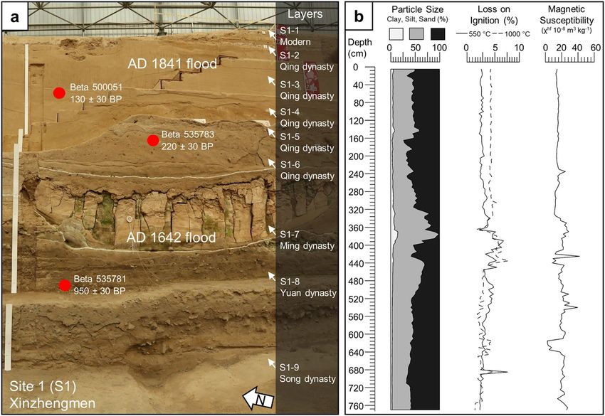
www.nature.com/scientificreports/                                                              www.nature.com/scientificreports

                           Figure 6. Dichen Xiyuan. (a) Panorama of excavations at Dichen Xiyuan. (b) Intact stratigraphic section of the
                           AD 1642 Yellow River flood. (c) Overturned ceramic vessel containing intact AD 1642 flood stratigraphy. (c)
                           Buried tree sampled for radiocarbon dating.

                           archaeological and paleoenvironmental record of exceptional floods, like the AD 1642 Yellow River flood, can
                           provide an important reminder that unexpected events have happened in the past and will likely happen again.
                           In extreme cases, these events can cause infrastructure built to prevent disasters to catastrophically fail, causing
                           significantly more devastation than under normal circumstances.

                           Methods
                           No statistical methods were used to predetermine sample size.

                           Soil profiles and samples from excavation. The results presented here are derived from salvage field
                           work conditions at Xinzhengmen, Yongning Wangfu, Dichen Xiyuan, Xinjiekou, and Yulongwan, limiting our
                           ability to present accurate geodetic information and artifact distribution data. Samples and measurements of the
                           lithostratigraphy and archaeostratigraphy at each site use standardized soil science terminology26. All bulk sam-
                           ples were collected at 5 cm intervals up column.

                           Sediment analysis. We sampled each stratigraphic layer identified at Yongning Wangfu and Xinzhengmen
                           and conducted particle size analysis, loss-on-ignition, and magnetic susceptibility on each sample. Particle size
                           analysis was done using a Malvern 2000 particle size analyzer. We conducted loss on ignition at 550 °C and 950 °C
                           to estimate the percentage of organic matter and inorganic carbon in each sample27,28. We also used a Bartington
                           MS2 Magnetic Susceptibility Meter to determine each sample’s high field magnetism (4.7 kHz)29.

Scientific Reports |   (2020) 10:3765 | https://doi.org/10.1038/s41598-020-60169-1                                                           8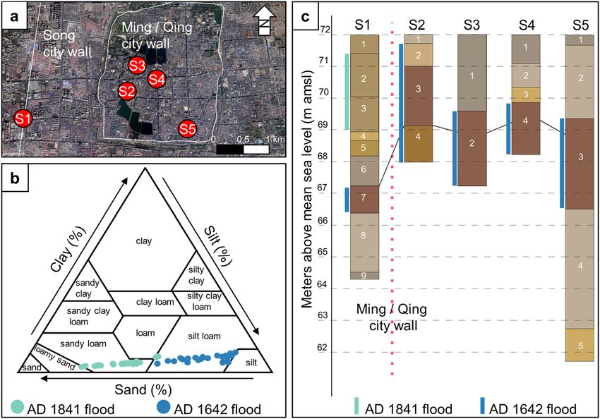
www.nature.com/scientificreports/                                                          www.nature.com/scientificreports

                           Figure 7. Xinjiekou. (a–c) Excavations at Xinjiekou where the wooden plaque was found (artifact number JZ9:
                           308).

                           Figure 8. Yulongwan. (a) Plan view of Yulongwan with locations of buildings and flood victims marked. (b)
                           Building with remains of wooden wheels and doors. (c) Two individuals found prone on a wooden bed.

                           Radiocarbon dating. We collected nine radiocarbon samples from wood, charcoal, and human remains and
                           sent them for accelerator mass spectrometry radiocarbon dating at Beta Analytic. Accelerator mass spectrometry
                           radiocarbon dates from Xinzhengmen, Yongning Wangfu, Yulongwan, and Dichen Xiyuan. Dates are calibrated
                           with BetaCal 3.21 using the IntCal13 dataset30,31.

Scientific Reports |   (2020) 10:3765 | https://doi.org/10.1038/s41598-020-60169-1                                                     9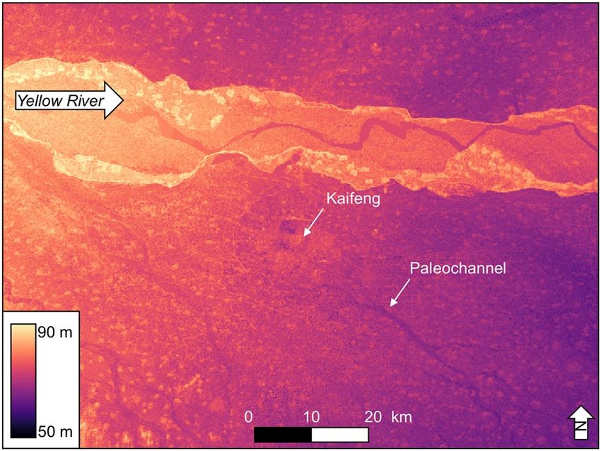
www.nature.com/scientificreports/                                                              www.nature.com/scientificreports

                           Figure 9. Urban stratigraphy of Kaifeng. (a) Locations of sites mentioned in the text, Xinzhengmen (S1),
                           Yongning Wangfu (S2), Dichen Xiyuan (S3), Xinjiekou (S4), and Yulongwan (S5) (Imagery from Google Earth
                           Pro, Digital Globe). (b) Particle size differences between the AD 1642 and AD 1841 Yellow River flood deposits.
                           (c) Summarized stratigraphic evidence from each excavation, the black line connects each of the AD 1642 flood
                           deposits. Note that the flood deposit is found several meters deeper beneath the modern land surface outside
                           the Ming dynasty city walls than inside the city walls.

                           Figure 10. 90 m SRTM DEM of Kaifeng and surrounding area. The DEM highlights the paleochannels around
                           the site, specifically, the paleochannel coming out to the southeast of Kaifeng may be the relict channel of the
                           AD 1642 flood deposit (Data available from the U.S. Geological Survey).

                           Paleohydrology.        Using the bulk density of typical clay material, (1.6 g/cm3) we calculated that about 6.4
                           tons of clay are needed to deposit 4 m of sediment over 1 m2 area. This means that at least 6.4 m of water column
                           stacked over 1 m2 of water is necessary (i.e. 6.4 m3 of volume) in a relatively stagnant condition so that sediments
                           could settle down, assuming the flooded water’s suspended sediment concentration was 1,000 mg/l.

                           Data availability
                           All data generated or analyzed in this study are included in the paper and its Supplementary Information. Site
                           descriptions, radiocarbon dates, and ternary plots of particle size are presented in Supplementary Information.
                           All remaining soil samples are curated at the Kaifeng Institute of Archaeology and Cultural Relics.

Scientific Reports |   (2020) 10:3765 | https://doi.org/10.1038/s41598-020-60169-1                                                         10
www.nature.com/scientificreports/ www.nature.com/scientificreports
Received: 8 May 2019; Accepted: 31 January 2020;
Published: xx xx xxxx
References
1. Ernstson, H. et al. Urban transitions: on urban resilience and human-dominated ecosystems. Ambio 39, 531–545 (2010).
2. Meerow, S., Newell, J. P. & Stults, M. Defining urban resilience: A review. Landscape and urban planning 147, 38–49 (2016).
3. Leichenko, R. Climate change and urban resilience. Current opinion in environmental sustainability 3, 164–168 (2011).
4. Smith, M. E. Sprawl, squatters and sustainable cities: Can archaeological data shed light on modern urban issues? Cambridge
Archaeological Journal 20, 229–253 (2010).
5. Salomon, F. et al. Geoarchaeology of the Roman port-city of Ostia: Fluvio-coastal mobility, urban development and resilience.
Earth-Science Reviews 177, 265–283 (2018).
6. Baker, V. R. Palaeoflood hydrology in a global context. Catena 66, 161–168, https://doi.org/10.1016/j.catena.2005.11.016 (2006).
7. Liao, K.-H. A theory on urban resilience to floods—a basis for alternative planning practices. Ecology and society 17 (2012).
8. Aldrete, G. S. Floods of the Tiber in ancient Rome. (JHU Press, 2007).
9. Chen, Y., Syvitski, J. P., Gao, S., Overeem, I. & Kettner, A. J. Socio-economic impacts on flooding: a 4000-year history of the Yellow
River, China. Ambio 41, 682–698, https://doi.org/10.1007/s13280-012-0290-5 (2012).
10. Zhang, L. The River, the Plain, and the State: An Environmental Drama in Northern Song China, 1048–1128. (Cambridge University
Press, 2016).
11. Mostern, R. Sediment and state in imperial China: The Yellow River watershed as an earth system and a world system. Nature and
Culture 11, 121–147 (2016).
12. Wu, Q. et al. Outburst flood at 1920 BCE supports historicity of China’s Great Flood and the Xia dynasty. Science 353, 579–582,
https://doi.org/10.1126/science.aaf0842 (2016).
13. Kidder, T. R. & Zhuang, Y. J. Anthropocene archaeology of the Yellow River, China, 5000-2000 BP. Holocene 25, 1627–1639, https://
doi.org/10.1177/0959683615594469 (2015).
14. Storozum, M. J. et al. The collapse of the North Song dynasty and the AD 1048–1128 Yellow River floods: Geoarchaeological
evidence from northern Henan Province, China. The Holocene 28, 1759–1770 (2018).
15. Wu, P., Liu, D., Ma, J., Gu, L. & Tong, J. Reconstructing the man-made Yellow River flood of Kaifeng City in 1642 AD using
documentary sources. International Journal of Disaster Risk Reduction 41, 101289 (2019).
16. Liu, C. Kaogu Kaifeng [The archaeology of Kaifeng]. (Henan Daxue Chubanshe, 2006).
17. Qiu, G., Li, H. & Liu, C. Kaifeng Kaogu faxian yu yanjiu. (Zhongzhou Guji Chubanshe, 1998).
18. Ge, Q. S. Beisong ducheng xinzhengmen yizhi yu kaifeng “cheng luo cheng” [The Xinzheng Gate Site in the Northern Song Dynasty
capital city Kiafeng “cheng luocheng”]. Dazhong Kaogu 10, 36–40 (2014).
19. Ye, F., Fang, X. & Li, F. Response and recovery measures for two floods in north China during the nineteenth century: a comparative
study. SpringPlus 5, 1985 (2016).
20. Dodgen, R. A. Salvaging Kaifeng: Natural Calamity and Urban Community in Late Imperial China. Journal of Urban History 21,
716–740 (1995).
21. Kidder, T., Liu, H., Xu, Q. & Li, M. The Alluvial Geoarchaeology of the Sanyangzhuang Site on the Yellow River Floodplain, Henan
Province, China. Geoarchaeology 27, 324–343, https://doi.org/10.1002/gea.21411 (2012).
22. Wang, S. Henan kaifeng xinjiekou ming zhou wangfu guanshu yizhi fajue jianbao [Excavation bulletin of the Ming dynasty Wangfu
Guanshang site, Xinjiekou, Kaifeng, Henan]. Wenwu 2017, 39–72 (2017).
23. Walder, J. S. & O’Conner, J. E. Methods for predicting peak discharge of floods caused by failure of natural and constructed earthen
dams. Water Resources Research 33, 2337–2348 (1997).
24. Costa, J. E. Paleohydraulic reconstruction of flash-flood peaks from boulder deposits in the COlorado Front Range. Geological
Sociiety of America Bulletin 98, 986–1004 (1983).
25. Chang, S. D. Some observations on the morphology of Chinese walled cities. Annals of the Association of American Geographers 60,
63–91 (1970).
26. Schoeneberger, P. J., Wysocki, D. A., Benham, E. C. & Broderson, W. D. Field Book for Describing and Sampling Soils. Vol. 44 (Natural
Resources Conservation Service, USDA, National Soil Survey Center, 1998).
27. Nelson, D. W. & Sommers, L. E. in Methods of Soil Analysis: Part 3—Chemical Methods Vol. 961-1010 (eds D. L. Sparks, A. L. Page,
P. A. Helmke, & R. H. Loeppert) (Soil Science Society of America, 1996).
28. Heiri, O., Lotter, A. F. & Lemcke, G. Loss on ignition as a method for estimating organic and carbonate content in sediments:
reproducibility and comparability of results. Journal of Paleolimnology 25, 101–110 (2001).
29. Dalan, R. A. & Banerjee, S. K. Soil magnetism, an approach for examining archaeological landscapes. Geophysical Research Letters
23, 185–188, https://doi.org/10.1029/95gl03689 (1996).
30. Bronk Ramsey, C. Recent and Planned Developments of the Program OxCal. Radiocarbon 55, https://doi.org/10.2458/azu_js_
rc.55.16215 (2013).
31. Reimer, P. J. et al. IntCal09 and Marine09 Radiocarbon Age Calibration Curves, 0–50,000 Years cal BP. Radiocarbon 51, 1111–1150,
https://doi.org/10.1017/s0033822200034202 (2009).
Acknowledgements
The study is funded by the National Natural Science Foundation of China (Grant Nos. 41971016, 41671014,
41701014), the National Social Science Foundation of China (Grant No. 18CKG003), the Study of Environment
Archaeology in Zhengzhou, and the Digital Environment Archaeology Specially-appointed Researcher of Henan,
China. The authors are grateful to the 65th China Postdoctoral Science Foundation Grant (2019M651399) for
financial support. We are also thankful to members of Department of Cultural Heritage and Museology at Fudan
University for useful discussions.
Author contributions
M.S., P.L. and S.W., designed the study and supervised the field work. M.S., P.L., H.W., Z.Q. and E.P. wrote the
main manuscript. P.C. prepared the figures and conducted the laboratory analyses. R.Y., Q.G., J.C., J.W. and H.L.
conducted the archaeological investigations. E.P. conducted the paleohydraulic investigation. M.S., P.L. and H.W.
conducted the geoarchaeological investigation. All authors revised the manuscript and approved the final version.
Competing interests
The authors declare no competing interests.
Scientific Reports | (2020) 10:3765 | https://doi.org/10.1038/s41598-020-60169-1 11www.nature.com/scientificreports/ www.nature.com/scientificreports
Additional information
Supplementary information is available for this paper at https://doi.org/10.1038/s41598-020-60169-1.
Correspondence and requests for materials should be addressed to M.S., P.L. or S.W.
Reprints and permissions information is available at www.nature.com/reprints.
Publisher’s note Springer Nature remains neutral with regard to jurisdictional claims in published maps and
institutional affiliations.
Open Access This article is licensed under a Creative Commons Attribution 4.0 International
License, which permits use, sharing, adaptation, distribution and reproduction in any medium or
format, as long as you give appropriate credit to the original author(s) and the source, provide a link to the Cre-
ative Commons license, and indicate if changes were made. The images or other third party material in this
article are included in the article’s Creative Commons license, unless indicated otherwise in a credit line to the
material. If material is not included in the article’s Creative Commons license and your intended use is not per-
mitted by statutory regulation or exceeds the permitted use, you will need to obtain permission directly from the
copyright holder. To view a copy of this license, visit http://creativecommons.org/licenses/by/4.0/.
© The Author(s) 2020
Scientific Reports | (2020) 10:3765 | https://doi.org/10.1038/s41598-020-60169-1 12You can also read


