GEOTOUR 2016 Proceedings of the - UNICA IRIS Institutional Research ...
←
→
Page content transcription
If your browser does not render page correctly, please read the page content below
Proceedings
           of the
       GEOTOUR 2016
 International Conference on
 Geotourism, Mining Tourism,
Sustainable Development, and
  BOOK OF ABSTRACTS
  Environmental Protection

                   18-20 October 2016
           Aula Magna of the SAGAS Department,
                   Università di Firenze

                              Editors
   Ugolini F., Marchi V., Trampetti S., Pearlmutter D., Raschi A.
                       IBIMET-CNR, Firenze.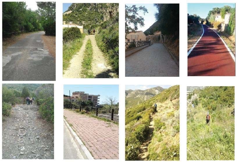
International conference on Geotourism, Mining Tourism, Sustainable Development, and Environmental Protection,

Scientific Committee
Antonio Raschi, Director of Institute of Biometeorology-National Research Council, Italy
Anna Paganoni, President of the Italian Association of Geology and Tourism, Italy
Massimo Coli, University of Florence and Italian Association of Geology and Tourism, Italy
Margherita Azzari, professor at Department of History, Archaeology, Geography, Fine and
Performing Arts (SAGAS), University of Florence, Italy
Michal Cehlár, Professor at the Technical University of Kosice, Faculty of Mining, Ecology, Process
Control and Geotechnologies, Slovakia
Monika Hardygora, Professor at KGHM Cuprum Research and Development Center, Wroclaw, Poland
Pavol Rybár, Dr.h.c. Professor at the Technical University of Kosice, Faculty of Mining, Ecology,
Process Control and Geotechnologies, Slovakia
Patrizia Romei, Professor at the Department of Economics and Management (DISEI), University of
Florence, Italy
Rodolfo Coccioni, Professor at the University of Urbino, Responsible of Settimana del Pianeta Terra,
Italy
Silvio Seno, Professor at the University of Pavia, Responsible of Settimana del Pianeta Terra, Italy
Tadeusz Słomka, Professor at AGH University of Science and Technology, Cracow, Poland
Teresa Caldarola, Public Officer for Economy and Sustainable Tourism projects, Tuscany Region,
Italy
Thomas A. Hose, Professor at the School of Earth Sciences, University of Bristol, UK

Organizing committee
Francesca Caporossi, Institute of Biometeorology-CNR, Italy
Francesca Ugolini, Institute of Biometeorology-CNR, Italy
Valentina Marchi, Institute of Biometeorology-CNR, Italy
Sonia Trampetti, Institute of Biometeorology-CNR, Italy
Lubomis Strba, Technical University of Kosice, Faculty of Mining, Ecology, Process Control and
Geotechnologies, Slovakia

Organisations
Institute of Biometeorology-National Research Council, Italy
Associazione Italiana Geologia e Turismo, Italy
Libera Associazione Malghesi e Pastori del Lagorai, Italy
Department of History, Archaeology, Geography, Fine and Performing Arts (SAGAS), University of
Florence, Italy
Department of Economics and Management (DISEI), University of Florence, Italy
Settimana del Pianeta Terra, Italy
University of Pavia, Italy
University of Urbino Technical University of Kosice, Faculty of Mining, Ecology, Process Control and
Geotechnologies, Slovakia
Tuscany Region, Italy

Book of Abstracts of the GEOTOUR2016 Conference. International Conference on Geotourism, Mining
Tourism, Sustainable Development, and Environmental Protection. 18-20 October 2016, Firenze.
Ugolini Francesca, Marchi Valentina, Trampetti Sonia, Pearlmutter David, Raschi Antonio (Eds.)

Published and printed by IBIMET-CNR, Firenze.
ISBN: 978-889-559-73-17

                                        18-20 October 2016, Florence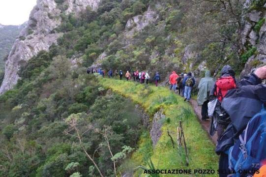
International conference on Geotourism, Mining Tourism, Sustainable Development, and Environmental Protection,

                                       PROCEEDINGS
                       GEOTOUR2016 CONFERENCE
                                         18-20 October 2016
                                 Aula Magna of the SAGAS Department,
                                         University of Firenze

                                           ORGANISERS

                                               In the frame of

                                            With the patronage of

                                        18-20 October 2016, Florence
SUMMARY

PROTECTION AND PROMOTION OF GEOTOURIST ATTRACTIONS .................................. 1
MINING TOURISM AND ITS POSITION IN RELATION TO OTHER FORMS OF TOURISM ............ 2
GEOTOURISM: FROM “GRANTOUR TO ETNA 2016” - THE EXPERIENCE OF THE ITALIAN
ASSOCIATION OF GEOLOGY AND TOURISM ............................................................................... 8
CREATING DEMAND FOR THE TOURIST PRODUCT DURING THE IMPLEMENTATION OF
GEOTOURIST PROJECT FOR POST-MINING OBJECTS ............................................................. 12
GEOTOURISM AND TOURISM IN GEOSITES AND GEOPARKS ....................................... 20
PLACEMENT OF GEOPARKS IN THE SYSTEM OF TERRITORIAL PROTECTION OF NATURAL
HERITAGE IN SLOVAKIA ............................................................................................................... 21
COEXISTENCE OF THE SLOVAK KARST NATIONAL PARK AND PROPOSED SILICA GEOPARK:
PROS AND CONS .......................................................................................................................... 27
ALPONE VALLEY: FAUNAS, FLORAS AND ROCKS FROM THE CENOZIC................................. 32
UNVEIL THE TRACES OF ANCIENT MINING................................................................................ 38
MINING TOURISM ....................................................................................................... 45
THE MINING PATH OF SANTA BARBARA IN THE SULCIS IGLESIENTE IN SARDINIA (ITALY)
BETWEEN MEMORY AND RE-USE ............................................................................................... 46
THE RIO MARINA MINES (ELBA ISLAND): A CULTURAL HERITAGE TO BE REVALUED .......... 53
HOLIDAYS AT THE MINE – THE LUSATIAN EXPERIENCE .......................................................... 59
ECOTOURISM, SUSTAINABLE DEVELOPMENT .............................................................. 66
RURAL RESOURCES AS AN OPPORTUNITY FOR TOURISM DEVELOPMENT IN ALBANIA ..... 67
CROSS BORDER COOPERATION THROUGH THE TOURISM PROMOTION PROJECT IN ASIA:
A CASE STUDY OF BUSAN AND FUKUOKA ASIA GATEWAY 2011 PROJECT .......................... 74
DEVELOPMENT OF GEOTOURISM IN AREA WITH DISPERSED SETTLEMENT (CASE STUDY
OF NOVA BANA REGION, SLOVAKIA) .......................................................................................... 78
GEO-MILLTOUR: INNOVATIVE GEO-TOURISTIC ROUTES ALONG THE HISTORIC
WATERMILLS IN BASILICATA (SOUTHERN ITALY) ..................................................................... 84
GEOLOGY, NATURAL HERITAGE AND TOURISM ........................................................... 90
BETWEEN HEAVEN AND EARTH, A GEOSHAMANIC JOURNEY IN THE HAWAIIAN ISLANDS . 91
GEOMORPHOSITES: THE INTERWEAVE OF TOURISTIC EXPLOITATION AND THE NATURAL
PROCESSES CAUSING THEM. CASE STUDY: THE GEOMORPHOSITE OF ASYAB–KHARABEH
CATCHMENT AND TUFA COMPLEX ............................................................................................. 95
UNDERGROUND SPACES BUILT FOR NON-MINING PURPOSES AS IMPORTANT
PHENOMENON OF MINING HERITAGE ..................................................................................... 102
STONE IN ARCHITECTURE AND SCULPTURE – SOURCE MATERIAL FOR RECONSTRUCTION
...................................................................................................................................................... 109
TOURISM PRODUCTS AND TOURISM DEVELOPMENT................................................. 115
STRATEGIC POSITION OF A TOURISM DESTINATION IN THE LIGHT OF SWOT ANALYSIS: A
CASE STUDY OF POLISH SPA RESORTS ................................................................................. 116
CREATIVE TOURISM – A FUTURE PRODUCT OF SLOVAK TOURIST REGIONS? .................. 122
THE DEVELOPMENT OF GEOTOURISTIC FACILITIES IN A HUNGARIAN MOUNTAIN RESORT
...................................................................................................................................................... 128
International conference on Geotourism, Mining Tourism, Sustainable Development, and Environmental
                                                  Protection,

NATURAL RESOURCES, ENVIRONMENTAL PROTECTION AND TOURISM .................... 132
GEOTOURISM DEVELOPMENT IN THE PROTECTED AREA LLOGARA-KARABURUN ........... 133
GEOSITES AND ANTHROPOGENIC LANDFORMS IN UPPER SILESIAN COAL BASIN WITH
REGARD TO FORMS OF ENVIRONMENTAL PROTECTION...................................................... 138
SELECTED GEOTOURISTIC SITES OF ETHIOPIA ..................................................................... 144
NEW TECHNOLOGIES AND APPS IN GEOTOURISM .................................................... 148
NEW TECHNOLOGIES FOR THE SUSTAINABLE DEVELOPMENT OF CULTURAL ROUTES: THE
CASE STUDY OF THE HOLY FACE ROUTE IN GARFAGNANA REGION AND IN THE SERCHIO
RIVER MIDDLE VALLEY .............................................................................................................. 149
THE USE OF INTERACTIVE VIDEOTOUR FOR GEOTOURISM DEVELOPMENT OF ARTIFICIAL
WATER RESERVOIRS IN ŠTIAVNICA MOUNTAINS................................................................... 155
“LANDSCAPP”: A FRIENDLY WAY TO SHARE THE ITALIAN GEO-HERITAGE ......................... 160
GEOLOGY, NATURAL HERITAGE AND TOURISM ......................................................... 167
THE GHR PROJECT: NEW TOOLS AND STRATEGY FOR AN HISTORICAL GEOTOURISM ... 168
WHEN HISTORY OF GEOLOGY MEETS TOURISM: THE HISTORICAL ROUTES OF THE
GEOSCIENCES IN THE ALPS ..................................................................................................... 174
EXAMINING THE GEOTOURIST VALUE OF LANDSCAPE FEATURES. CASE STUDY: THE
VYŽNE RUŽBACHY IN THE SPIŠ REGION, NE SLOVAKIA ........................................................ 175
DESTINATION MANAGEMENT AND PUBLIC CHOICES ................................................ 185
AN ALTERNATIVE TOURISM FRAMEWORK FOR LOW DEMOGRAPHIC DENSITY AREAS .... 186
THE POTENTIAL FOR TOURISM IN PERIPHERAL RURAL SETTLEMENTS ............................. 190
MOTIVATION FOR PARTICIPATING IN GEOTOURS .................................................................. 197
MOTIVATION OF GENERAL PUBLIC (GEO)TOURISTS TO VISIT GEOSITES: A CASE STUDY
FROM SLOVAKIA ......................................................................................................................... 203
POSSIBILITIES OF IMPLEMENTATION AND UPDATE OF THE EUROPEAN TOURISM
INDICATORS SYSTEM VIA TUKE’S DESTINATION BUSINESS INFORMATION SYSTEM: CASE
STUDY OF DESTINATION TOKAJ REGION (SLOVAKIA) ........................................................... 207
POSTERS ................................................................................................................... 213
DESTINATION BUSINESS INFORMATION SYSTEM – EFFECTIVE TOOL FOR TOURISM
PRODUCT DEVELOPMENTS ...................................................................................................... 214
PROCEDURE FOR EVALUATION OF THE ATTRACTIVENESS OF THE QUARRIES’ LANDSCAPE
...................................................................................................................................................... 215
LOCATION BASED GAME TO DISCOVER FOLLONICA - “THE TOWN OF THE CAST IRON” ... 223
HONG LIN (GUIZHOU - CHINA): A NATURAL HERITAGE FOR KNOWLEDGE AND PROTECTION
IN AN AREA UNDERGOING RAPID TRASFORMATION ............................................................. 229
INDICATORS’ SYSTEM FOR MONITORING TOURISM DESTINATIONS: THE CASE OF OTD IN
TUSCANY REGION ...................................................................................................................... 230
THE MINING PATH OF SANTA BARBARA IN THE SULCIS
IGLESIENTE IN SARDINIA (ITALY) BETWEEN MEMORY AND RE-
USE
G. Balletto, C. Garau, M. Pinna, P. Zamperlin
Department of Civil and Environmental Engineering and Architecture, DICAAR, University of Cagliari, Italy
balletto@unica.it, cgarau@unica.it, zamperlin@unica.it
Abstract
The territory of Sulcis-lglesiente is characterized by the significant presence of abandoned mining sites
(113 of the total 169 sites in Sardinia are present there). This paper focuses on the Mining Path of
Santa Barbara (Cammino Minerario di Santa Barbara), a 400 km long circular route, and aims to revive
the memories of these places, proposing a geo-tourist path subdivided into 24 stops, for local
economic conversion, from little-known mineral deposits to tourist sites. The path through the Geo-
mining Park of Sardinia is in one of the oldest places in Europe.
The first part of this paper is devoted to the cognitive study of Sulcis-lglesiente territory and of the
case-study area. Following this, the authors propose a strategic tourist path for the Mining Path of
Santa Barbara (the patron saint of miners and of everyone who deals with fire risks) in which it will be
possible, not only to bring back the ancient paths of the miners (from home to work), but also to restore
the fascinating mining infrastructure such as railways and roads, the main means of communication.
The proposed strategic tourist route thus provides sustainable mobility and a communication tool of
the various mining centers and with appropriate variations, can be crossed by trekking, cycling and on
horseback using bridle paths. The data are collected in a geodatabase with information on the precise
positioning of the signs and the points of interest with particular attention to geological, natural,
architectural, historical and industrial archeology, in addition to the list of receptivity and museums.
This paper ends by presenting the results of research.
Keywords: mining villages, cultural tourism, Sulcis-Iglesiente, geotourism, sustainable tourism
Introduction
This paper focuses on the drafting of the Mining path of Santa Barbara (Cammino Minerario di Santa
Barbara), located in the Sulcis-Iglesiente in Sardinia (Italy) that has significant signs of past mining
activities. It is a tourist-hiking infrastructure, addressed to active tourism 1 developed throughout
Europe and recently also in Sardinia (Fortezza, 2015).
Material and Immaterial procedures of recovery and of enhancement have been researched, identified
and developed for about 20 years in the Geo-mining Historical Environmental Park of Sardinia,
recognized by UNESCO in 1998. The drafting of the Mining Path of Santa Barbara is located in this
place-based context, upon the proposal of several associations, among which is the "Onlus Pozzo
Sella for the Geo-mining Park Association”.
The mining path of Santa Barbara is like a ring extending about 400 kilometers, and is subdivided into
24 stages, with the aim of interconnecting the mining villages, located in the territory of Sulcis-
Iglesiente and of Guspinese, using old mining paths (cart tracks and mule tracks, railways, paved
1
Active tourism is characterized by outdoor activities, also with a strong identitarian connotation (such as: trekking, climbing, mountain bikes,
etc.). In Sardinia it can be practiced in all seasons because of favorable climatic conditions
(http://www.regione.sardegna.it/j/v/40?s=1&v=9&c=7106&na=1&n=10&va=2).roads and bridges, etc.), in order to help the area flourish and also to commemorate the historical memory of the places. Along the mining path of Santa Barbara, the old mining value is accompanied by strong environmental, archaeological and natural elements, that give the local context a particular uniqueness of its type between nature and artifice (Balletto et al., 2012; 2013). In this regard, the authors propose a geo-tourist path, in order to enhance not only the disused mining context, but also the environmental and natural features of that same context. The Sulcis-Iglesiente and the case study area The French geographer Pierre Birot described the Sardinian landforms as a residual of Hercynian base, with multiple faults, covered by the secondary and Eocene strip, and in the western part hidden by volcanic accumulations, due to activity started in the Oligocene. Plateaus are the most common shape of relief, with high precipitous costs, that create a beautiful and wild landscape (Birot, 1955). In this synthesis he brought to light the origin of antiquity and the fragmentation of the Sardinian landforms. The western part of the island is very heterogeneous in terms of morphology and geology. In the southwest Sardinia, the region called Sulcis-Iglesiente, evidence appears of granitic rocks, that some Geologists connect to mythological Tirrenide. This name was coined by CJ Forsyth Major in 1882 to designate the continent originating in the Mesozoic in the western Mediterranean area. Precisely the Iglesiente region, so named from the main urban center of Iglesias (the toponymy of which corresponds to the term "churches"), is characterized by the presence of abundant mineral resources, such as lead, zinc and especially coal, documented from ancient times. Deposits are located mainly in Silurian shales and limestones above the basic granite layers and contributed to the flourishing of a mining region among one of the richest in Italy. A gap between the Gonnesa Gulf and the lagoon of Cagliari clearly separates this block into two parts: the northern one, culminating in the granite mass of the Linas (1,236 m). Here the most important mines are located on the western side, from Montevecchio to Monteponi, with a concentration of activities on Iglesias. The southern block is constituted by Sulcis region, and is characterized by plateaus arranged in a series from the northwest to the southeast (the Nieddu Mount). The subsoil abounded with bituminous coal and lignite picea (so colled Sulcis coal), that were extracted in the Bacu Abis and Carbonia areas (Almagià, 1959; Mezzolani, 2007). The mining path of Santa Barbara (Figure 1) is placed in an area with strong landscape and environment connotations whose geology dates back some 550 million years ago, which also gives a value of paleontological, mineralogical and caving type (Aymerich et al., 2003). The previous mining activities in the Sulcis region bequeathed serious phenomena of pollution and environmental damage, as well as a system of particularly innovative mining infrastructure2 (such as: the Porto Flavia gallery, first port on the sea, built in 1924, using an excavation inside the mountain of about 600 meters and designed to improve the economic efficiency and working conditions; the Henry Gallery, excavated in 1865 and designed for the transport of minerals; the first electric-powered railroads, such as Cala Domestica installed in 1904 among the first in Italy, for the transport of minerals in small ports). Part of these structures has been restored, enhanced and made accessible. The most significant examples are: the Villa Marina Gallery, Pozzo Sella (the Monteponi mine), the Old Central in Buggerru mine, the Management and the Pozzo Sant'Antonio (the Montevecchio mine), the Santa Barbara Gallery (the Rosas mine), the gallery and the loading facility of Porto Flavia (the Masua mine), and the Henry Gallery (Buggerru). 2 The mining system of Sardinia has very ancient origins as early as in prehistoric times, but the nineteenth century highlighted the best production results, involving international mining companies, and triggering innovative achievements, through the progressive start of new technological processes.
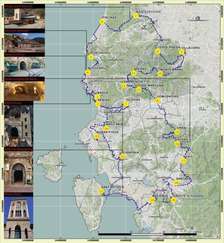
Figure 1. The mining path of Santa Barbara
     (Graphic elaboration of Michele Pinna. Source of the images: the Henry Gallery [Bugerru] and the Monteponi, and the
               Masua mines www.igeaspa.it; the Montevecchio mine www.comune.guspini.vs.it; the Rosas mine
                                                www.sardegnadigitallibrary.it)

Detection method and design of the Santa Barbara Path
During the preliminary stage, the definition of the mining path of Santa Barbara was made possible by
identifying the route through the study of maps, documentary evidence, photographic repertoires and
analysis of landscape, environmental and mining points of interest (POIs). A reference model for the
design of the path has defined, after consulting the bibliography (Azzari et al., 2004; Zamperlin, 2010;
Garau, 2015; Buhalis et al., 2015; Boes et al., 2016), and the numerous case studies of the Emilia
Romagna Region, that is at the forefront for detection and realization of hiking tourist infrastructures3.
In a second phase, a recognition in the field was performed (Figure 2), during which the previously
processed paths were verified and then the related digital data were acquired, preparing in this way
the geodatabase and the final cartographic elaborations.
The total length of the path (about 400 km) and the diversity of the POIs to be inventoried involved a
significant number of people with different disciplinary expertise, from geology, landscape planning, to
architectural history and natural sciences.
The state of consistency and of maintenance to the mining path as well as the infrastructure with the
identification of possible restoration work have been subject of particular attention. During the
detection stage, the routes were mapped both as linear elements (classified into different types of

3
    Emilia Romagna Region 2013.
roads and paths, etc.) and as punctual elements of interest (POIs), including different types of signage,
settlements, water points and picnic areas. Two devices were used, a Garmin GPS "Monterra" model,
and a smartphone, both with Android OS which allowed the installation on devices of two applications,
respectively "OruxMaps" (free download) on the Garmin, and "Supersurv" of the SuperGeo society
(commercial version) on the smartphone.
Figure 2. The mining path of Santa Barbara
The use of two different devices is justified by the different precision characteristics in the acquisition
of the data: the Garmin, equipped with high-precision GPS, was used to record the tracks (linear traits
and POIs), while the smartphone was used to record tracks and POIs in a compatible format with GIS
software. In addition, the smartphone made it possible to match data, through an easy interface,
already during the detection of the path file, by recording data with standard identification codes of the
Italian Alpine Club (Club Alpino Italiano CAI), speeding up the population of the database. In particular,
Figure 3 shows some typologies of viability (codes T01 T04): dirt roads (codes T01 C01), paved
carriage roads (codes T01 C02), and cobbled carriage roads (codes T01 C03); dirt mule tracks,
charcoal burning and abandoned railways roads (codes T02 C01); bridleways and cycle paths with
tarmac pavement (codes T02 C02); and paved mule tracks (codes T02 C03); paths (codes T03 C01)
and unbeaten tracks (codes T04 C01).
Figure 3. Main typologies of collected roads
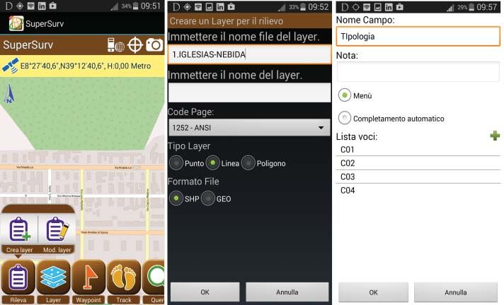
The track recording phase is schematically represented by the three screens shown in Figure 4.Figura 4. Screenshots obtained during the creation of the shapefile and related tables
Table 1 shows the summary scheme of the 24 routes designed according to the following
characteristics:
1. presence of one or more places of worship dedicated to Saint Barbara
2. the path length, between 10 and 20 km
3. accommodation, mainly resulting from the recovery of mining facilities
Table 1. Kilometers and incidence as a percentage of the individual sections and associated typologies
Tracking routes of mining path of Saint Barbara
Routes km % TIPOLOGY km %
Total 395.18 100.00 395.18 100.00
1. Iglesias – Nebida 14.88 3.77 T03 C01 32.71 8.28
2. Nebida – Masua 9.43 2.39 T04 C01 26.97 6.83
3. Masua – Buggerru 19.82 5.02 T02 C01 62.84 15.90
4. Buggerru – Portixeddu 11.21 2.84 T02 C02 2.34 0.59
5. Portixeddu – Piscinas 16.70 4.23 T02 C03 23.38 5.92
6. Piscinas – Montevecchio 19.12 4.84 T01 C01 160.50 40.61
7. Montevecchio – Perde
Pibera 22.42 5.67 T02 C02 79.52 20.12
8. Perde Pibera – Villacidro 15.29 3.87 T01 C03 6.92 1.75
9. Villacidro – Monte Mannu 18.12 4.58
10. Monte Mannu – Arenas 15.51 3.93
11. Arenas – San Benedetto 12.54 3.17 Difficulty T (TURISTIC) 188.86 47.79
12. San Benedetto - Case
Marganai 8.59 2.17 Difficulty H (HIKING) 205.16 51.92
13. Case Marganai – Difficulty EH (EXPERT
Domusnovas 11.06 2.80 HIKING) 1.16 0.29
14. Domusnovas – Orbai 16.23 4.11 395.18 100.00
15. Orbai – Rosas 16.57 4.19
16. Rosas – Nuxis 15.71 3.97 Railways 53.04 13.42
17. Nuxis – Santadi 17.55 4.44 inclined surfaces 518.529 131.21
18. Santadi – Grotte Is Zuddas 18.27 4.62 0.00
19. Grotte Is Zuddas –
Masainas 20.08 5.08
20. Masainas – Sant'antioco 23.82 6.03 forest institution 40.12676 10.15
21. Sabt'antioco – Carbonia 21.49 5.44 Geo-mining Park 373.54 94.52
22. Carbonia – Nuraxi Figus 19.48 4.93 SIC 149.527 37.84
23. Nuraxi Figus – Bacu Abis 15.48 3.92 disused mining areas 89.57 22.67
24. Bacu Abis – Iglesias 15.82 4.00 Fauna oasis 10.31 2.61Discussion and conclusions The systematization of all the geo-historical information relating to the interest in sites belonging to the mining path of Saint Barbara and the digital acquisition of the tracks, contextual to working towards the assessment of their state of practicability and overall conservation of artifacts, confirmed the potential in terms of cultural and environmental tourism of the Geo-mining Historical environmental Park of Sardinia, unfortunately still not fully expressed. For these reasons, the project of an application intended for possible users of the mining path started, in order to encourage attendance by facilitating their access to information. Currently the demo application, called SULKY_WALKABILITY, is under revision and is expected to be available by 2016. The sustainable mobility infrastructure proposal is compliant with the guidelines of the Region of Sardinia on the "identitarian, Cultural and Religious Tourism"4, which aims to offer active tourism in Sardinia in major national and International tourism networks. In addition, the mining path of Saint Barbara is also to be understood as an intangible identitarian heritage, not only because of the historical, economic, and environmental reasons relating to the mining path, but also in a Smart Territory approach along the mining path. In fact, the latter can create renewed ties between territorial contexts in the past subjected to mining activities that compromised its environmental integrity, in favor of a new cultural tourist sustainable use. This careful research of the natural, historical and cultural heritage, which was followed by a mapping for the recovery and development of critical areas for a wider usability, should be the starting point for the recovery, enhancement and sharing of cultural and environmental heritage (tangible and intangible) that were originated in the economic exploitation of a territory, but it left evident signs of an age-old relationship that has taken place here between man and environment, with a strong identitarian connotation. The next step is to provide the entire territory of Sulcis Iglesiente with a contribution oriented to sustainable mobility, enjoyment of sport and well-being, whose careful management can create local economic development. Acknowledgements This paper is the result of the joint work of the authors. In particular, ‘Detection method and design of the Santa Barbara Path’ has been jointly written by the authors. Chiara Garau has written the introduction. Paola Zamperlin has written ‘The Sulcis-Iglesiente and the case study area’, and Ginevra Balletto has written ‘Discussion and conclusions’. This study is supported by the MIUR (Ministry of Education, Universities and Research [Italy]) through a project entitled Governing tHe smart city: a gOvernance-centred approach to SmarT urbanism - GHOST (Project code:RBSI14FDPF; CUP Code: F22I15000070008) financed with the SIR (Scientific Independence of young Researchers) programme. We authorize the MIUR to reproduce and distribute reprints for Governmental purposes notwithstanding any copyright notation thereon. Any opinions, findings and conclusions or recommendations expressed in this material are those of the authors and do not necessarily reflect the views of the MIUR. References Aymerich C., Rettig J. M., & Stochino, M. (Eds.). 2003. Archeologia industriale: esperienze per la valorizazzione in Cile e Sardegna: atti del Convegno internazionale, Cagliari 11 dicembre 2003. Gangemi. Azzari M., Cassi L. 2002. Itinerari turistico culturali in Toscana, Florence University Press. 4Official page of the Region of Sardinia dedicated to tourism: http://www.regione.sardegna.it/argomenti/turismo/
Azzari M. Cassi L. Meini M. 2004. Cultural itineraries in Tuscany. Firenze: Firenze University press.
Balletto G., Furcas C., Scalas A. 2012. The changes in the landscape perception as a result of the
   natural and human dynamics. Paysage. Promozione e Sviluppo per l’Architettura del Paesaggio,
   vol. 9: 1545-1554.
Birot P. 1955. Les méthodes de la morphologie, Paris, Presses Universitaires de France
Boes K., Buhalis, D., & Inversini, A. 2016. Smart tourism destinations: ecosystems for tourism
   destination competitiveness. International Journal of Tourism Cities, 2(2):108 - 124
Buhalis, D., & Amaranggana, A. 2015. Smart tourism destinations enhancing tourism experience
   through personalisation of services. In Information and Communication Technologies in Tourism
   2015. Springer International Publishing: 377-389.
Carmignani L., Conti P., Funedda A., Oggiano G., Pasci S. 2008. La geologia della Sardegna 84°
   Congresso Nazionale della Società Geologica Italiana, Sassari 15-17 settembre 2008.
Club Alpino Italiano 2010. Sentieri Pianificazione e Manutenzione, 4° Edizione
Fantinel A., Lampis B., Magari O., Cali R. 2011. Bacu Abis - Storia e racconti di vita, Edizioni Sulcis.
Fortezza, F. 2015. Marketing e creazione di valore per il territorio. Evidenze e spunti di riflessione dal
   caso Ferrara: Evidenze e spunti di riflessione dal caso Ferrara. Franco Angeli, Milano.
Garau, C. 2015. Perspectives on Cultural and Sustainable Rural Tourism in a Smart Region: The Case
   Study of Marmilla in Sardinia (Italy). Sustainability,7(6), 6412-6434.
Mezzolani S. 2007. Sardegna da Salvare Storia, Paesaggi, Architetture delle Miniere Il Parco
   Geominerario Storico Ambientale della Sardegna. Editrice Archivio Fotografico Sardo.
Perna G. 1998. Condizioni dell'industria mineraria nell'isola di Sardegna : relazione del deputato Sella
   alla Commissione d'inchiesta della Camera dei deputati, Sessione 1870-71, Cagliari. Mediteranean
   communications company, 1998.
Pinna G. 2013. Il Cammino Minerario di Santa Barbara, 5° Congresso Nazionale di Geologia e
   Turismo, Bologna 5 – 6 Giugno 103; Atti Ispra.
Regione Autonoma della Sardegna 1998. Il Parco Geominerario Storico Ambientale della Sardegna,
   Sintesi del dossier presentato all'Unesco.
Regione Emilia Romagna 2013. REER – manuali, Rete Escursionistica Emilia-Romagna, Rilevamento
   con       GPSMAP®62s.        Aggiornamento          nov.     2013,     http://ambiente.regione.emilia-
   romagna.it/geologia/cartografia/rete-dei-sentieri/rilevamento
Scalas A., Balletto G., Furcas C. 2013. Overcoming the anachronistic utopia in ancient quarries: the
   restoration project of an abandoned quarry site in the Monumental Cemetery of Bonaria in Cagliari,
   Italy. In Proceedings of the International Scientifical Conference, Udine, June 27th - 28th, 2013,
   Volume III: 143-154.
You can also read