GERMANY: A BALANCED PLANNING SYSTEM - Scottish Land ...
←
→
Page content transcription
If your browser does not render page correctly, please read the page content below
GERMANY: A BALANCED PLANNING SYSTEM

Germany

                                      Summary
                     Germany: A Balanced Planning System

                      Contractor: University of Glasgow & University of Liverpool
                                    Author: Dr Sebastian Dembski
                                       Year of publication: 2020

Keywords
Housing; Planning; Netherlands

Background
The Universities of Glasgow and Liverpool were commissioned to assess experience from other
European countries in the role of housing land allocation and assembly in enabling the delivery of
high-quality affordable housing and placemaking. This report has been prepared as part of the
project ‘Housing land allocation, assembly and delivery: Lessons from Europe.’

Main findings
− Germany has a well-established and relatively stable planning system, which provides a
  balanced set of land policy instruments to deliver affordable housing and placemaking.
− Local authorities generally work collaboratively with market actors on land allocation, assembly
  and delivery, including mandatory land readjustment. Local authorities are in a strong position
  because of their exclusive right to approve land use plans which is required for most
  developments.
− Placemaking quality and land value capture are part and parcel of the land use planning
  process and often secured via public contracts, including in some cases implementation.
− Increasing housing market pressures in metropolitan areas has clearly stimulated a debate
  about a more proactive use of the existing land use policy instruments for housing land
  allocation, assembly and delivery.

For further information on this project contact:
David Stewart, Senior Policy Officer
Tel: 01463 423 300
Germany

Table of Contents                                                                                                                   Page

1.   INTRODUCTION ......................................................................................................... 1
2.   HOUSING DELIVERY AND PLACEMAKING ............................................................ 3
3.   THE GERMAN PLANNING SYSTEM ......................................................................... 6
     3.1    Administrative structure ............................................................................................ 6
     3.2    Main legislative frameworks ...................................................................................... 6
     3.3    System of plans .......................................................................................................... 7
     3.4    The instruments for local planning authorities ........................................................ 9
            3.4.1 The Preparatory Land Use Plan ....................................................................... 9
            3.4.2 The Binding Land Use Plan .............................................................................. 9
            3.4.3 Other Land policy instruments ........................................................................ 12
     3.5    Summary ................................................................................................................... 14
4.   HOUSING LAND ALLOCATION, ASSEMBLY AND DELIVERY IN GERMANY ..... 15
     4.1    Land allocation ......................................................................................................... 15
     4.2    Land assembly .......................................................................................................... 16
     4.3    Delivery ..................................................................................................................... 18
     4.4    Summary ................................................................................................................... 19
5    EXEMPLARY PROJECT: BAHNHOF HEUBRUCH, WUPPERTAL ........................ 20
     5.1    Land allocation ......................................................................................................... 20
     5.2    Land assembly .......................................................................................................... 21
     5.3    Delivery ..................................................................................................................... 22
     5.4    Summary ................................................................................................................... 25
6    LESSONS FOR SCOTLAND .................................................................................... 26
7.   REFERENCES .......................................................................................................... 28
Germany Acknowledgements We would like to thank Prof Sabine Baumgart, President of the ARL – Academy for Territorial Development in the Leibniz Association and Partner at BPW Stadtplanung, Bremen; Marcus Behnke, Aurelis Real Estate; Prof Torsten Bölting, EBZ Business School – University of Applied Sciences and Director InWIS; Christoph van Gemmeren, Regierungsbaudirekor Bezirksregierung Düsseldorf; Prof Johanna Schoppengerd, Osnabrück University of Applied Sciences; Thomas Seck and Marc Walter, Stadt Wuppertal for sharing their valuable time and insights. The case study also benefitted tremendously from the German Law Archive in translating German legal terms into English.1 All errors of judgement and fact remain of course mine. 1 https://germanlawarchive.iuscomp.org (accessed 15 May 2020).
Germany

1. INTRODUCTION
Germany is characterised by a decentralised urban spatial structure with a number of large
urban centres (Figure 1). This is partly the result of the political structure, which aimed to
deconcentrate power after World War II. More than 30 years after Reunification, divisions
between East and West Germany persist, with states in the former East economically still
lagging behind. To a lesser extent this also applies to small and medium towns and rural
areas in the periphery (BBSR, 2017).

Figure 1. Spatial Structure of Germany with main cities and exemplary case study
(underlined).

Germany has a comprehensive planning system and is frequently mentioned as an
exemplar country, albeit perhaps not to the same degree as the Netherlands. It has a
remarkably stable planning system (Schmidt, 2009). The International Building Exhibition
Emscher Park serves as a shining example for the regeneration of old-industrial regions.
Freiburg is frequently cited in textbooks on eco-urbanism for its continued efforts, producing
neighbourhoods such as the celebrated Vauban development (Falk, 2011). More recently,
HafenCity Hamburg has featured in international studies as inspiration for planners (Lord et

                                             1
Germany
al., 2015). Others have highlighted the strength of the planning system in creating mixed-use
neighbourhoods (Hirt, 2007).
In the following the report will briefly sketch the main trends of the planning debate in relation
to housing and placemaking. The subsequent section outlines the main features of Germany
in terms of administration, legal frameworks and system of plans and other instruments. The
next section will shed light on housing land allocation, assembly and delivery in practice.
This is illustrated in an example case study of a residential project in the city of Wuppertal.
The report ends with a summary of the main features of German planning and identifies
potential lessons for Scotland.
2Germany
2. HOUSING DELIVERY AND PLACEMAKING
The German planning debate has changed significantly over the past decade. In the 2000s
Germany was still debating urban regeneration and shrinking cities, in particular how to deal
with depopulated cities in the former East Germany (Bernt, 2019). Rents were low and the
state discontinued investment in social housing (Kirchner, 2007). The German housing
market was also largely unaffected by the 2008 Global Financial Crisis (Kofner, 2008).
Within a few years, discourse shifted radically, driven by reurbanisation and the increasing
pressure on urban housing markets (Brake & Herfert, 2012). This has since led to a vivid
debate on affordable housing, land policy and inward urban development (Die
Unterzeichnenden ‘Für eine wirklich soziale Wohnungspolitik’, 2018; Difu & VHW, 2017;
Voigtländer, 2017; Reiß-Schmidt, 2019).
Germany has pursued several policies in parallel, which involved promoting homeownership,
social housing and free market rental housing. Germany has been characterised as a
country with a unitary rental market, meaning that social and private rental markets are
integrated (Kemeny, 1995; Balchin, 1996). This is different from the UK, where social
housing is residualised. This assessment still holds more than two decades later.
Germany distinguishes dwellings according to the number of dwellings within the building,
which makes it difficult to compare with other countries using a different categorisation. More
than half of the German housing stock consists of dwellings in buildings with multiple
dwellings, which can be translated as flats. On average there are 6.7 dwellings per
residential building in this class. The remainder consists of dwellings in buildings with one
(31%) or two (15%) dwellings (Figure 2).
Germany has a comparatively low homeownership rate and a large private rental sector
(Figure 3). Only 43% of dwellings are owner-occupied of which approximately 25% are flats.
Homeownership has increased, but only slowly. The rental market is split between
professional and private landlords. Professional landlords, which together hold 21% of the
housing stock, is divided equally into the not-for-profit sector, consisting chiefly of co-
operatives and public housing corporations and commercial real estate companies. Most
flats are in the hands of private landlords with mostly a small portfolio of flats.
After years of relative stagnation, the German housing market has come under pressure.
Housing has become one of the leading political issues due to a number of factors. While
population growth is not an issue per se, the attractiveness of cities has been one of the
major drivers of rent and house price increases since 2010 (Dembski et al., 2020). In
particular younger population groups are ‘swarming’ into the cities (Simons & Weiden, 2016).
This was reinforced by an increasing net immigration of an often highly qualified labour
force. Rents in major cities have increased between 5 and 25% in Germany’s largest cities,
which has resulted in new, even stricter, rent regulations coming into force in 2015
(Deschermeier et al., 2016). At the same time in some rural areas there are high vacancy
rates (BBSR, 2017). Low mortgage rates have driven the owner-occupier market as buying
became relatively cheaper in spite of increasing house prices (Voigtländer, 2017). Housing
3Germany
experts agree that the German housing market is still far removed from a bubble
(Voigtländer, 2017).
Housing Stock and Construction, 2000–2018
45 350
Thousands
Millions
40
300
35
250
Housing construction
30
Housing stock
25 200
20 150
15
100
10
50
5
0 0
1 dwelling 2 dwellings 3 or more dwellings Residential establishments New dwellings
Figure 2. Dwelling stock and construction, 2000–2018 (Source: Federal Statistical Office
Germany)
Total Housing Stock
41.4m dwellings
Professional Landlords Private Landlords Owner-Occupiers
8.7m dwellings (21%) 15.0m dwellings (36%) 17.7m dwellings (43%)
Housing One- and two-family One- and two-family
Cooperatives houses houses
2.1m dwellings 4.7m dwellings 13.9m dwellings
Public Housing
Flats Flats
Associations
10.3m dwellings 3.8m dwellings
2.5m dwellings
Commercial Real
Estate Companies
3.9m dwellings
Other not-for-profit
organisations
0.2m dwellings
Figure 3. Housing tenure in Germany, 2018 (Source: GdW)
4Germany
In particular in urban areas, construction has not met demand. At the national level, housing
production was at 250,000 dwellings per annum, which is roughly in line with the identified
housing need, but there was a strong regional imbalance with an overproduction in rural and
less prosperous areas while there was a shortage in the metropolitan areas and major
university towns (Voigtländer, 2017). The two main reasons for the shortfall in housing
delivery are building land supply and construction costs (Voigtländer, 2017). The shortage of
building land has resulted in dramatic price increases which in turn encouraged speculation
(Voigtländer, 2017). Bringing new sites forward has become increasingly challenging due to
nimby-behaviour and a shortage of town planners (Voigtländer, 2017). Suburban local
authorities have often little interest in releasing additional building land because of the
necessary infrastructure investments (Voigtländer, 2017). Construction costs for new builds
have increased significantly, partly due to increased standards (e.g. energy efficiency, fire
safety) and developer contributions to local infrastructure, which in turn make affordable
housing less attractive (Voigtländer, 2017).
While the cost of housing has increased, the social housing stock has decreased
continuously since the 1960s and makes up a very small percentage of the total housing
stock (Kirchner, 2007). This is partly due to the nature of social housing in Germany, which
is time limited. The provider of social housing receives subsidies for providing housing that is
subject to rent control and access restrictions (Kirchner, 2007). After a period of usually 20-
30 years the subsidy conditions elapse and the dwellings transfer into the private rental
market. As construction of new social housing fell behind, the stock has reduced.
National policy is clearly in favour of promoting development within the existing built-up area,
in Germany referred to as inward development (Innenentwicklung). Since the early 2000s,
the Federal Government has the ambition to reduce new land uptake to below 30ha per day
until 2030 (The Federal Government, 2017). Although it has significantly reduced land
uptake since the mid-2000s, with 56ha per day in 2018 it is still well above the target.2 There
is sufficient potential for densification to accommodate the predicted household growth
(Schiller et al., 2013). One problem is also the continued increase of the living space per
capita from 39.5sqm in 2000 to 46.5 sqm in 2017.3
2 https://www.bmu.de/themen/nachhaltigkeit-internationales/nachhaltige-entwicklung/strategie-und-
umsetzung/reduzierung-des-flaechenverbrauchs/ [Accessed 15 May 2020]
3 https://www.inkar.de [Accessed 15 May 2020]
5Germany
3. THE GERMAN PLANNING SYSTEM
Germany’s planning system is classified as part of the comprehensive-integrated family,
though also exhibiting some features of the regional economic family (Berisha et al. 2020). In
a recent classification, the system has been identified as more market-led and more
performative (Berisha et al. 2020).
3.1 Administrative structure
Germany is a federal country consisting of 16 states (Bundesländer or Länder in short),
including three cities (Berlin, Bremen and Hamburg) with the status of a Land. Most Länder
have a regional tier, which is usually not directly elected. Germany has a two-tier local
government consisting of 294 counties (Landkreise) and nearly 10,000 communities
(Gemeinden), while 107 large cities are unitary authorities (kreisfreie Städte). There is strong
variation between the Länder in terms of average population size and boundary changes.
The median population size is around 1,700 but varies between less than 600 in Rhineland-
Palatine and more than 20,000 in North Rhine-Westphalia, which had a municipal reform in
the 1970s. In particular in the Länder that formed the GDR, the number of municipalities has
declined rapidly over the past decades, whereas in most other Länder the numbers
remained remarkably stable since the 1970s independent of their size.
The municipal right to self-government is an important feature of the German constitution
(Art. 28 Basic Law) and is particularly important to planning. The degree of municipal
independence depends on the municipal status, which is by and large the result of
population size. Many smaller municipalities form a statutory corporation
(Gemeindeverband) to be able to carry out their statutory duties. Nevertheless, a large
number of municipalities and statutory corporations are very small and have therefore only a
small planning service.
Municipalities are funded through a mix of national, state and local sources, though their
financial position has come under pressure. Taxes account for approx. 30% of municipal
revenues. Land tax (Grundsteuer) and business tax (Gewerbesteuer) are the most important
locally raised taxes, which account for more than half of the tax revenues. That makes
municipalities keen to develop and oversupply land in particular for industrial and
commercial development (Schmidt, 2009, p. 1911). Only 25% of municipal revenues comes
directly from the Länder, of which approximately half are earmarked subsidies (Schmidt-
Eichstaedt et al., 2019). About 45% stems from fees and obligations as well as municipal
revenues from economic activities and loans. Although the financial position of municipalities
has greatly improved as a result of the positive economic development since the mid-2000s,
there are huge regional disparities (Deutscher Städtetag, 2018)
3.2 Main legislative frameworks
Planning Law is part of competing legislation (konkurrierende Gesetzgebung), that is areas
where the Länder are responsible until the Federal level makes laws. This was the case with
the Federal Building Act in 1960 and the Spatial Planning Act in 1965 (Pahl-Weber &
6Germany
Henckel, 2008). Planning is known as Raumordnung (regional planning) at the federal and
state level, and Bauleitplanung (urban land use planning) at the local authority level, each
with their own legal framework. This division is also reflected in the laws that guide planning
in Germany: the Federal Regional Planning Act (Raumordnungsgesetz – ROG) deals with
the general aims and objectives of planning and provides some basic rules for state and
regional plans (supra-local planning), while the Federal Building Code (Baugesetzbuch –
BauGB) is primarily responsible for planning at the local level. Housing land allocation,
assembly and delivery is mainly regulated through urban land use planning, which is why the
focus in on the Federal Building Code and related legislation.
The Federal Building Code is the result of a merger of the Federal Building Act and the
Urban Development Act (Städtebauförderungsgesetz – StBauFG) in 1987, which has since
been amended and revised several times: faster procedures (1997), Environmental Impact
Assessment (2001) and Strategic Environmental Assessment (2004), urban densification
(2007), energy transition and climate change (2011) to name just a few. The intervals
between revisions have shortened (Krautzberger, 2007; Schmidt-Eichstaedt et al., 2019).
Since 2007 the BauGB includes an environmental paragraph promoting sustainable
development (§1a). Despite numerous reforms since its inception, the core of the legislative
framework has been remarkably stable.
The Federal Building Code authorises the Federal Government to draft a number of statutes.
The most important is the Federal Land Use Statute (Baunutzungsverordnung – BauNVO),
which establishes a common system of use classes. Furthermore, the Plan Notation Statute
(Planzeichenverordnung – PlanZV) establishes a common system of symbols for the land
use plans. Together with the Federal Building Code they ensure that local planning practices
are very similar across Germany and that land use plans look uniform across Germany.
In addition, there are numerous sectoral laws influencing planning decision, of which we
shall briefly mention the most relevant. The Federal Nature Conservation Act (Bundesnatur-
schutzgesetz – BNatSchG) requires compensation for most spatial intervention, which is
known in German as Eingriffs-Ausgleichsregelung. The Federal Immissions Control Act
(Bundesimmissionsschutzgesetz – BImSchG) is very influential due to the principle of
functional separation of conflicting land use (§ 50 BImSchG). In particular ambient noise is a
perennial problem in mixed-use areas and poses challenges for urban densification. The
Technical Guidance on Ambient Noise (Technische Anleitung Lärm) defines permissible
ambient noise levels for each use class.
3.3 System of plans
Similar to the legislative framework, the system clearly distinguishes between supra-local
and local plans. Planning in Germany is characterised by vertical coordination rather than a
strictly hierarchical decision making; this is referred to as the counter-current principle
(Gegenstromprinzip) in which the lower level influences decision-making. Nevertheless,
once approved, there is a clear plan hierarchy. In the following the main plans for each of the
three administrative tiers are outlined (Table 1).
7Germany
Table 1. Overview of the German planning system (Source: adapted from Pahl-Weber &
Henckel, 2008, p. 41)
Level Instrument Legal basis Policy maker
Federal Planning Concepts and Federal Regional Standing Conference of
(Bundesraumordnung) Strategies for Spatial Planning Act Ministers of Spatial
Development (Raumordnungsgesetz) Planning (MKRO)
State Planning State Development Federal Regional State Government
(Landesplanung) Plan Planning Act and State
(Landesentwicklungspla Planning Acts
n)
Regional Planning Regional Plan Federal Regional Regional Planning
(Regionalplanung) (Regionalplan) Planning Act and State Authority*
Planning Acts
(Landesplanungsgesetz
e)
Local Planning Preparatory Land-Use Federal Building Code Municipal Council
(Bauleitplanung) Plan (Baugestzbuch) (Gemeinderat)
(Flächennutzungsplan)
Binding Land-Use Plan
(Bebauungsplan)
* In Lower Saxony, the counties are responsible for regional planning, which means that no regional
plan exists in cities with a unitary local government. In the city states the local preparatory land use
plan is also a regional plan.
Planning remains largely a decentralised affair and there are no national comprehensive
spatial plans, with the exception of marine spatial planning in the exclusive economic zone.
Federal spatial planning occurs mainly through sectoral plans, mainly in the field of technical
infrastructure, and informal instruments. Yet even some of the important sectoral plans, such
as the Federal Transport Infrastructure Plan (Bundesverkehrswegeplan) have a strong input
from the Länder. The Standing Conference of Ministers responsible for Spatial Planning
(Ministerkonferenz für Raumordnung – MKRO), consisting of the federal and state ministers,
formulates guidelines for spatial development mainly at federal and state level planning, the
latest dating from 2016 (BMVI, 2016).
There is huge variation in regional planning, as it is strictly a matter for the Länder. Most
Länder4 have a two-tier system of a state-wide plan (Raumordnungsplan) and regional plans
for the subregions (Regionalplan), with slightly different names in each Land. The state-wide
plan defines the aims and objectives of spatial planning and often includes provisions on
spatial categories, central places and corridors. Regional planning is usually delegated to
4The city states (Berlin, Bremen and Hamburg) and the Saarland have a single-tier system due to small
size. In the city states, the preparatory land use plan may serve as a regional plan.
8Germany
regional planning associations (Regionale Planungsverbände) or state administrative
authorities (Regierungsbezirke).5 Most regional plans have in common that they define the
spatial structure in terms of built-up area, open space and infrastructure (Pahl-Weber and
Henckel, 2008; Wickel, 2018). They specify the objective of spatial planning and as such are
binding on local authorities. Some regional plans include for instance enforceable minimum
densities for new development.
Local planning is referred to as Bauleitplanung and also consist of a two-tier system of plans:
the preparatory land use plan (Flächennutzungsplan) and the binding land use plan
(Bebauungsplan). The preparatory land use plan outlines the future spatial development of
the entire city for the next 15–20 years. It provides a framework for the legally binding land
use plans, which are drawn up for areas where it is considered necessary for urban
development. Many areas in German cities are not covered by a binding land use plan and
are therefore directly regulated by §34 BauGB, which gives planning permission if the
scheme blends in with their surroundings (Hirt, 2007).
3.4 The instruments for local planning authorities
In the following, the focus will be on local plans and main land policy instruments that are
relevant for housing land allocation, assembly and delivery.
3.4.1 The Preparatory Land Use Plan
The preparatory land use plan outlines the future spatial development of the entire territory
of a municipality, by indicating the general land uses and important (social, technical and
transport) infrastructures. It is intended for a period of 15–20 years, although there is no end
date. Many municipalities have plans that are dated. In practice it is a relatively dynamic plan
which will be amended several times during its lifespan. It is not unusual that a preparatory
land use plan has been amended more than a hundred times in a large local authority. The
preparatory land use plan has no formal legal status and provides no direct property rights to
landowners. Nevertheless, it is an important document, as the local planning authority is
bound by it, as well as other sectoral plans. The regional preparatory land use plan
introduced in 1998 is a specific form, as it combines the function of a regional plan and a
preparator land use plan, but has not yet been applied widely.
3.4.2 The Binding Land Use Plan
The binding land use plan (Bebauungsplan) was initially intended to cover the whole territory
of a city (similar to the Dutch bestemmingsplan), but in practice this turned out to be
unrealistic because of the costly and lengthy procedures (Schmidt-Eichstaedt et al., 2019).
This is the only plan which is legally binding, and the rules remain in force until amended or
lifted. Binding land use plans are usually but not necessarily connected to concrete
development projects, because of the significant efforts that have to go into plan approval. A
binding land use plan is required for all developments that cannot be realised via §34 BauGB
in built-up areas or where public local infrastructure is not secured.
5 The exception is Lower Saxony where the counties are responsible for regional planning.
9Germany
The local planning authority has great freedom of how much it wishes to regulate in a land
use plan, depending on the purpose of the plan. Land use plans are distinguished in terms of
content and process (Table 2). In terms of content, land use plans are distinguished into
qualified and non-qualified plans. Only a qualified land use plan directly provides building
rights. In order to be considered a qualified plan, i.e. provide building rights, it needs as a
minimum include rules on the “type and extent of use for building, the land on which built
development may take place and spaces dedicated as public thoroughfares” (§30 BauGB).
Non-qualified or simple land use plans only regulate certain aspects, e.g. as retail planning,
leisure, climate change, green infrastructure (Schmidt-Eichstaedt et al., 2019). In terms of
process, a distinction is made between a simplified and a standard process.
Table 2. Typology of land use plans
Process
Simplified
§13 Simplified §12 Project and
Procedure Development Plan
§13 Simplified
Procedure
§13a Built-Up Area
Plans
§13b Small-Scale
Residential Extensions
non-qualified qualified
§9 Binding Land Use §9 Binding Land Use
Plan Plan
Content
Standard
An important element of a binding land use plan is the designation of the type of land use or
use class (Art der baulichen Nutzung). The four main use classes of the preparatory land
use plan (residential, mixed, commercial and special) are subdivided into 12 detailed use
classes, which are uniform across the county, though local planning authorities are allowed
to enable or prohibit some uses as long as the character of an areas is not changed).
Recently Mixed-Use Urban Areas have been added as a new category to reflect the
increased demand for housing in inner-city areas without having to adhere to the
environmental restrictions of residential areas and the cap on housing in mixed-use areas
(Baumgart, 2019). All use classes, except special uses, are quite broad and allow for some
10Germany
degree of mixing, with mixed-use classes even mandating it (Hirt, 2007). By definition, these
use classes allow for different dwelling types (with the exception of the in an urban context
little used Small-Scale Residential (Kleinsiedlungsgebiet), which is limited to one- or two-
family dwellings) (Hirt, 2007). German planning has a positive attitude towards mixed-use
development and change of use is relatively easy with broadly defined use classes (Hirt,
2007).
Furthermore, most binding land use plans will include provisions regarding the extent of land
use (Maß der baulichen Nutzung), such as floor-space ratio, building height or number of
storeys; land on which built development may take place (überbaubare Grundstücksfläche),
such as lot lines and setbacks; and public thoroughfares (örtliche Verkehrsfächen) required
for access. Beyond these minimum requirements for a qualified binding land use plans the
municipality is free to regulate other aspects of land use.
The Project and Infrastructure Plan (Vorhaben- und Erschließungsplan) (§12 BauGB) is not
dissimilar to a planning application in the UK. A landowner approaches the municipality with
a concrete plan for development, including servicing the land, within a mutually agreed time
frame which will then be translated into a proper B-Plan or even only be attached in its
original form to the municipal ordinance. This has the advantage that the servicing costs will
be entirely covered by the developer. The municipality is free to accept, require amendments
or refuse the project. This instrument also has the advantage that is requires the investor to
realise the plan within a certain timeframe, otherwise it can be lifted. Some local authorities
also started to use this plan to test the seriousness of a proposal – an investor who is not
prepared to pay for a B-Plan is likely to postpone construction.
Since 2007, it is possible to use the simplified procedure (vereinfachtes Verfahren, §13
BauGB), which until then was limited to minor amendments or extensions of existing BPlans,
for small and medium-sized projects (up to 7ha of land on which built development may take
place) in the built-up area as long as they help reduce land consumption (§13a BauGB). This
included simplified procedures for public participation and stakeholder engagement, no need
for an environmental statement (up to 2ha of land on which built development may take
place)/assessment so long as there is no indication of significant impacts, correction of F-
Plan, as well as no nature compensation for small projects. This instrument was clearly
designed to speed up planning procedures and promote urban development within the
existing built-up area. With the increased housing market pressures, the instrument was also
extended to small-scale residential urban extension (up to 1ha of land on which built
development may take place) for a limited time (§13b BauGB). In practice, the main benefits
of these amendments seem to be related to the waving of the environmental reporting and
nature compensation (Jehling et al., 2019). In particular the §13b BauGB was criticised as
the aims are in direct contradiction with §13a BauGB and it is undermining the role of the
preparatory land use plan. Also, the waiving of nature compensation weighs particularly
heavy in the outer area (Jehling et al., 2019).
11Germany
All type of binding land use plans can be combined with an Urban Development Contract
(§12 BauGB). This covers a range of contracts under public law which safeguard public
policy objectives that cannot be regulated via a binding land use plan, including the costs of
planning and servicing. Proportionality is an important principle.
3.4.3 Other Land policy instruments
Land assembly and land value capture are considered important element of a planning
system. In terms of land assembly, planning law provides a range of instruments to support
the public sector in providing building land in terms of pre-emption rights, land readjustment
and compulsory purchase. Land value capture refers to the attempt of the state to capture
the increase in land value, originating from planning decisions, public works or the general
development of the land market. We shall outline the relevant instruments in planning law.
Germany is well known for mandatory land readjustment (Crook, 2018), which is a key
instrument in creating land parcels that are suitable for development in terms of location,
shape and size (§45 BauGB). Landowners will own a different and often smaller plot of land
than before, but their land is at least as valuable as before (Davy, 2007). It means that
fragmented landownership no longer impedes development – be it because of unwilling
landowners or high transaction costs – while the heavier instrument of compulsory purchase
can be avoided. It is beneficial to landowners, as they receive building land that is
developable and to the local authority as it can realise public policy objectives. It can only be
applied within the built-up area or in conjunction with a binding land use plan.
The process for mandatory land readjustment is a well-established but also complex
procedure (Davy, 2007; Crook, 2018; Kötter, 2018; Schmidt-Eichstaedt et al., 2019). Once
the decision for mandatory land readjustment is taken, it is taken forward by the Independent
Readjustment Authority (Umlegungsstelle) within the local authority. Once land is pooled
virtually (Umlegungsmasse), land for public infrastructure, including land for environmental
compensation that is mainly required for the area is removed. In so doing, it captures the
land costs for servicing the land. The remaining land (Verteilungsmasse) will be redistributed
based on the standard of relative price or relative size. This also involves land value capture,
as the local authority keeps the readjustment gain, but not the planning gain (Davy, 2007;
Schmidt-Eichstaedt et al., 2019). If the value method is used, landowners need to pay the
difference in price. If the standard of relative size is used, the municipality can claim up to
30% of the land (or 10% if previously developed). There is also a simplified procedure for
direct exchanges of land without any deductions of land for public infrastructure.
There is broad agreement that mandatory land readjustment has many benefits, as it
respects a number of fundamental principles (Davy, 2007; Kötter, 2018; Schmidt-Eichstaedt
et al., 2019). Land readjustment protects private property; it is not a taking of property as
each landowner receives a plot of equal or higher value. It is fair in the sense that
landowners pay for improvements to their property. At the same time, landowners benefit as
their property increases in value. The Constitutional Court has confirmed in 2001, that land
readjustment primarily serves private interests and is not a regulatory taking (Davy, 2007;
12Germany
Kötter, 2018). Finally, it underlines the primacy of planning by adjusting land for the public
good (Davy, 2007; Kötter, 2018).
Mandatory land readjustment is a powerful instrument to mobilise building land (Davy, 2007;
Kötter, 2018). It is also less costly than compulsory purchase, while still allowing for some
land value capture. While voluntary land readjustment is the preferred procedure by law, in
practices mandatory land readjustment is often faster, provides more certainty and despite
the deduction of the readjustment gain not more costly as landowners will need to pay all
costs in a voluntary procedure (Kötter, 2018). In effect, many mandatory land readjustment
procedures are effectively instigated voluntarily to benefit from these advantages (Davy,
2007).
The urban development measure (städtebauliche Entwicklungsmaßnahme) is a heavy-
handed instrument for the development of unused or underutilised land in which the
municipality designates an urban development zone, acquires the land at use value,
services the land before the land is sold off to future residents. Similar to mandatory land
readjustment, the municipality recoups all planning and public local infrastructure costs. One
of the main differences with land readjustment is the focus on implementation, which is a
legal requirement. Furthermore, other instruments have to be exhausted to achieve public
policy goals (Friesecke and Weitkamp 2019).
Expropriation is an instrument of last resort. Despite the far-reaching legal text of §85(1)
BauGB referring to the implementation of a land use plan, §87(2) BauGB restricts
expropriation to “individual cases where this is required for the general good and the
purpose to be served by expropriation cannot reasonably be achieved by any other means”.
The owner is compensated at market value of the current use, which explicitly excludes any
speculative gains due to expected changes in land use. While a very effective instrument in
specific circumstances, the restrictions to its application and the procedural hurdles mean
that expropriation is not a suitable strategic instrument for urban development (Albrecht,
2018).
In terms of land value capture, the distinction into the cause of land value increases is
important. The BauGB formulates a general expectation that local planning authorities
recoup up to 90% of the cost for public works that are directly related to the plan from the
landowner, irrespective whether they plan to build or not. The 10% share for the local
planning authority reflects the benefits of new infrastructure for the wider public and also
prevents the construction of excessive local public infrastructure (Schmidt-Eichstaedt et al.
2019).
Land value capture beyond local public infrastructure is not an explicit goal of planning law.
The default position is that the public sector pays for the costs of planning and the landowner
enjoys the increased value of the land (planning gain). However, the Project and
Infrastructure Plan and the Urban Development Contract allow the public sector to recoup
planning costs and wider contributions to public infrastructure than the narrower stipulations
13Germany
regarding the Provision of Local Public Infrastructure (Erschließungsbeiträge). Mandatory
land readjustment even captures the part of the planning gain (Davy, 2007; Crook, 2017),
but only land value increases directly related to the readjustment process (Schmidt-
Eichstaedt et al., 2019). Planning is therefore not regarded as an activity to generate
additional municipal income.
3.5 Summary
The German planning system has remained very stable since its inception. It has seen
numerous amendments, some more substantive than others, but the core of the system did
not change. More recently, the frequency of amendments has increased, and it seems that
the Government has become more responsive to specific policy problems. Overall, the
planning system offers a complete range of instruments that address all aspects of land
policy.
14Germany
4. HOUSING LAND ALLOCATION, ASSEMBLY AND DELIVERY IN GERMANY
The following section shall outline how German planning operates in practice. It highlights
important trends in the application of different instruments and reflects on their usefulness.
The structure follows the process of housing delivery, which begins with the allocation of
building land, assembly and land value capture, and delivery.
4.1 Land allocation
Building land is officially identified in a two-tier process. The regional planning authority
outlines the spatial structure based on population and economic projections. From a housing
perspective, the areas designated as general settlement areas (ASB) are most relevant for
local planning authorities. The regional level designations are very coarse and will be further
specified in the local preparatory land-use plan, providing a framework for the development
of binding land-use plans.
There is a fine power balance between the regional and the local level. The Regional Plan is
prepared in consultation with municipalities according to the so-called ‘counter-current
principle’ (Gegenstromprinzip), but overriding regional interests prevail and as such the
regional plan is an important element of development control (Siedentop et al., 2016). It also
helps that regional planning is less politically exposed than other tiers of government
(Wickel, 2018). Regional planning is a typical example of land-use planning based on the
conformance principle (cf. Mastop & Faludi, 1997). The regional planning authority can
designate land for residential development, but it cannot enforce housing land allocation in
local land use plans (see also Schmidt, 2009). An increasing number of municipalities in
particular in metropolitan areas refuses allocation of new building land. Regional planning
authorities can only persuade municipalities by using sound evidence to allocate building
land. In some cases, in particular where the regional planning authority is officially part of the
state government, withholding of urban development funds will enforce cooperation of most
municipalities, but will be futile with the wealthiest of municipalities.
While the German planning system is by definition comprehensive and plan-led, landowners
and the availability of land for development will have an impact on housing land allocation.
Certainly at the local level, the availability of sites is crucial in the planning process. The
preparatory land use plan has a recommended time horizon of 15-20 years, but in practice
plans can be much older. During its lifespan it will be amended numerous times, but usually
in response to development proposals.
The fact that there is not enough building land is not simply the fault of local authorities. Most
local planning authorities are generally willing to allocate sufficient housing land, but the devil
is often in the detail. The costs of development, in particular long-term costs relating to social
and technical infrastructure, may sometimes be higher than the returns from development in
terms of additional tax income (Preuß & Floeting, 2009). There is also increasing resistance
to new development prolonging planning process further (Voigtländer, 2017). Many
municipalities experience a situation of too much building land and not enough, which has
15Germany
been described by Davy (2000) as the building land paradox. Many landowners have
decided not to use their building rights, although municipalities have since moved towards
project planning with a clearer focus on implementation (Krautzberger, 2010).
Access to the land market in Germany has been relatively open in the past but has
increasingly become subject to speculative investment (Deutscher Bundestag, 2017). The
land market is relatively transparent and land values and house prices can be clearly
separated. The Boards of Expert Valuers (Gutachterausschüsse für Grundstückswerte)
produce small-scale reference land values (Bodenrichtwerte) for different land uses,
providing important orientation on the land market. These were introduced with the first
Federal Building Code in 1960. These are publicly available via an online platform (BORIS)
for the whole of Germany. Although creating market transparency, reference values do not
counteract price increases and can be considered a minimum value (Voß & Bannert, 2018).
4.2 Land assembly
Strategies vary greatly between local planning authorities, depending on size, market
context, urban morphology, planning traditions, etc. Some municipalities have a very active
land policy, while others leave land assembly almost exclusively to the market. As a general
rule of thumb, municipalities with a more buoyant real estate market are in a better position
to pursue an active land policy. Traditionally, planning has been heavily supply-driven by
allocating land for development and providing building rights (Schmidt, 2009). This has
become the exception rather than the rule and most municipalities have adopted a more
development-led strategy responding to private initiatives or public-sector led initiatives.
Increasingly, municipalities have become more proactive in providing building land for
specific dwelling populations groups.
This element of the planning process has been partially documented in the earlier study for
the Scottish Land Commission by Crook (2016). It is important to note that land assembly
itself is insufficient, as building rights can only be conferred if the provision of local public
infrastructure has been secured (§30 BauGB). Many instruments and strategies therefore
also address land value capture to put the required local public infrastructure in place to
transform unserviced land into fully serviced building land. The key instruments of the
Federal Building Code have been outlined above, but the practice of land assembly involves
numerous strategies that are beyond the scope of planning law (Figure 4).
Land assembly is possible via private or public actors. Public landownership provides more
options to realise public policy goals, but the instruments of the BauGB put municipalities in
a relatively strong position even under private landownership. Traditional supply-led planning
in which the municipality provides fully serviced building land for development have become
the exception due to the high planning cost. Many municipalities use a mix of instruments to
assemble land and achieve public policy goals.
Many municipalities may have sites where development is permissible because they are
covered by a binding land use plan (§30 BauGB) or are situated within built-up areas (§34
16Germany
BauGB) and already fully serviced, but landowners are unable or unwilling to develop.
Although the municipality cannot claim any planning or service costs as planning permission
and infrastructure is already in place, these sites form a huge potential in growing cities. The
city of Tübingen for instance, produced an inventory for all infill sites and evaluated their
suitability for development. Subsequently, landowners have been contacted directly asking
to build or sell off (to an investor or to the municipality at market value), but with moderate
success. Recently, the municipality threatened with a building order (Baugebot – §176
BauGB), with expropriation as last resort (Stuttgarter Nachrichten, 2019). The mayor justified
this heavy-handed instrument with the local housing market pressures and the social
obligation of property expressed in the constitution (§14 Basic Law). Kolocek (2018, p. 189)
has referred to the building order as “land policy instrument that does not work – to solve a
problem that does not exist”, because it is neither efficient nor effective to release building
land at the scale currently required.
Municipal land Municipal
acquisition via Urban landownership: land Public land
Private land market
Development banking and specific readjustment
Measure acquisition
Concepts,
Official land
direct
Heredi- Cooperative building readjustment
commis-
Resale at tary land models and (§§45-79 BauGB)
sioning,
market value building voluntary land and simplified
com-
rights readjustment land readjustment
petitive
(§§80-85 BauGB)
bidding
Urban Development
Private real estate contracts Contract (§11
BauGB) Landowner decides
on use of plots
Building order / Conditions: Tenures & types, building order,
tenures & types planning cost / planning obligations
Figure 4. Main land assembly strategies for German municipalities (Source: adapted from
Deutscher Verband für Wohnungswesen, Städtebau und Raumordnung, 2016, p. 13)
Mandatory land readjustment is an important instrument to deal with fragmented ownership
structure. It has the advantage that it creates no costs for the municipality, but it is a lengthy
process and implementation is not secured (Hartmann & Spit, 2015). Furthermore, additional
instruments are required to fully cover the planning and service costs, which require the
voluntary cooperation of the landowners via an Urban Development Contract (§11 BauGB).
This also allows land to be diverted for other goods, such as affordable housing, but the
legislator has capped the total amount of land that can be diverted (Kötter & Rehorst, 2019).
Not every city actually uses mandatory land readjustment. In one case, the readjustment
17Germany
authority (Umlegungstelle), which is part of municipal government, was discontinued due to
the high costs and the lack of cases.
Where land has been assembled by the private sector, but a land use plan is required, the
municipality it is free to negotiate with the landowner the conditions for development via a
Project and Development Plan (§11 BauGB) or Urban Development Contract (§12 BauGB).
As stated above, it is nowadays standard practice that the developer covers all planning
costs and delivers or pays for local public infrastructure which will be transferred into
municipal ownership after completion of the project. Some municipalities also demand
developer contributions towards public infrastructure costs beyond the plan area. The local
planning authority has the exclusive right to prepare a land use plan, which puts it in a really
strong position compared with its British counterparts. The municipality of Offenburg has
developed a building land model which is centred on voluntary land readjustment and Urban
Development Contracts as the main instrument, which apart from land value capture also
includes requirements for dwelling types and tenures and a building order. This has resulted
in a comparatively swift development process of an average of only two years and keeps the
costs for the public sector low (Deutscher Verband für Wohnungswesen, Städtebau und
Raumordnung, 2016).
Municipal landownership is the most powerful strategy to implement public policy goals and
many municipalities pursue an active land policy, although that clearly depends on the
financial reserves of each local authority. Municipalities can acquire land directly or make
use of extensive pre-emption rights at the standardised market value. Others use urban
development corporations to acquire and develop land. The city of Ulm is well known for its
proactive land policy for more than a century. To counter speculation, Ulm has acquired land
to develop affordable housing. Currently, the city refused to approve binding land use plans
if the land is not publicly owned. The municipality aims to acquire land at low value to keep
prices low while capturing all development costs. The city owns significant landholdings so
that it generally can develop sufficient housing units. In some cases, the municipality
concludes repurchase agreements with landowners.6
Local planning authorities have a range of instruments at hand to recover infrastructure and
planning costs. With the increasing financial pressures for local planning authorities, there is
more appetite to actually use these instruments. The Building Land Commission
(Baulandkommission, 2019) recommends providing land for affordable housing below
market prices and the use of hereditary building rights (Erbbaurecht).
4.3 Delivery
The local planning authority decides whether to prepare a land use plan or not, which puts it
in a really strong position. With the exception of building permits being issued based on the
6https://www.swr.de/swraktuell/baden-wuerttemberg/ulm/Das-kann-Gemeinde-Ulms-Weg-gegen-
Spekulation-mit-Grundstuecken,das-kann-gemeinde-grundstuecke-ulm-100.html [accessed 23 April
2020]
18Germany
blend-in rule of §34 BauGB, it means that the local planning authority has almost total
discretion, more so than its British counterparts as there is no Planning Inspectorate or
similar. The risk for the municipality is that a site will not be developed if it is economically
unviable.
The extent to which municipalities use their discretion to push for high-quality developments
and affordable housing varies with size and prosperity. It is good practice to demand urban
design competitions for larger schemes or important sites. There are different standards for
competitions ranging from an open architectural competition with an independent jury to
collaborative design workshops.
The making of a binding land use plan is generally a collaborative process between the
developer and the municipality. Municipalities will rarely draft new land use plans if there is
no investor lined up (Krautzberger, 2010). However, there will be detailed negotiations about
the provisions in terms of urban design quality and housing.
Since 2007, the majority of land use plans use the simplified procedure which can be applied
to all projects within the built-up area and even small-scale urban extensions. In this sense,
the exemption has become the rule (Krautzberger, 2014; Schmidt-Eichstaedt, 2019).
4.4 Summary
Germany’s planning system strongly focuses on procedures aiming to balance private and
public interests. It offers a relatively complete set of instruments covering all aspects of land
allocation and assembly. Municipalities, in particular cities, make full use of these
instruments and are proactive in the development process. The costs of development are
usually borne by the developer while the land value uplift is for the landowner.
19Germany
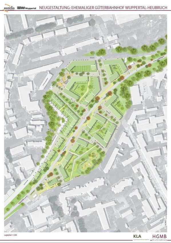
5 EXEMPLARY PROJECT: BAHNHOF HEUBRUCH, WUPPERTAL
The Bahnhof Heubruch is a mixed residential development involving over 300 dwellings on
5.5ha in the city of Wuppertal in the German state of North Rhine-Westphalia. It will be
developed on either side of the Nordbahntrasse, a former railway that closed in the early 1990s
and has since been converted into a popular cycle path. The actual site is the former
Heubruch station, situated a 10-minute walk from the centre of Barmen, which is the
secondary centre of Wuppertal. It is currently one of the most important residential projects
in Wuppertal (Wirtschaftsförderung Wuppertal, 2017). This project illustrates how planning
helps a German city to develop a high-quality residential project with affordable housing in a
less prosperous economic context.
5.1 Land allocation
The Bahnhof Heubruch was jointly identified for residential development in the early 2010s in
talks between the municipality and the current landowner Aurelis in relation to another
development which proved quite successful. Aurelis is a real estate developer founded as a
subsidiary of Deutsche Bahn, the national railway company, to manage land and buildings
no longer required, which has since been sold off and is now controlled by private equity firm
Redwood Grove International.7 As such it has substantial landholdings in German cities
which it develops and sells off to a building contractor, though the company has since
concentrated on asset management of commercial properties.
After the closure of the railway in 1992, the site was underutilised for more than two
decades. In the 1990s and 2000s, Wuppertal lost nearly 9% of its population, resulting in a
weak real estate market. Based on the successful development of another site in Wuppertal
and positive market signals, the local authority and the developer organised a workshop in
2013 with housing market actors to explore the potential for development but was met with
scepticism. It took a further two years until all parties were convinced that the site could be
developed, which was helped by potential solutions for soil remediation and the relocation of
the recycling centre, and the increased attractiveness of the location due to the opening of
the Nordbahntrasse.
Although the site has been identified as an important site for residential development (e.g.
Stadt Wuppertal, 2016), until this date land has not been officially allocated. This is partly the
result of the specific nature of the site as former railway, but also common practice in
German land use planning where land allocation is often reactive to private initiative. Despite
its central location, the area is located in the undesignated outlying area (Außenbereich),
notwithstanding that it was designated as general settlement area (ASB) built-up area in the
current Regional Plan and its predecessor (Bezirksregierung Düsseldorf, 1999, 2018). This
is because in the current preparatory land use plan, dating from 2005, the site is still
designated for railways and therefore not part of the built-up area. Land for railways is
governed by sectoral law (General Railway Act) and needs to be formally released
7https://www.aurelis-real-estate.de/aurelis/presse/pressemitteilungen/2014/aurelis-begruesst-neue-
shareholder-struk [accessed 14 April 2020].
20You can also read