GIS FOR EQUITY & SOCIAL JUSTICE - Greg Babinski King County Districting Committee
←
→
Page content transcription
If your browser does not render page correctly, please read the page content below
GIS   FOR   E QUITY & S OCIAL J USTICE

                      Greg Babinski
              King County GIS Center, Washington
                      © King County 2021
            King County Districting Committee
                     June 24, 2021

                                                   1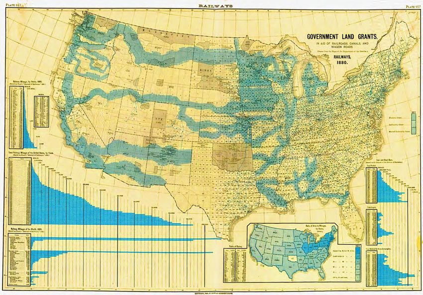
I NTRODUCTION TO GIS   FOR   E QUITY & S OCIAL J USTICE

       King County GIS acknowledges that we are on the
  traditional land of the first people of the region, the Salish
  People past and present, and honor with gratitude the land
   itself and the Duwamish, Lummi, Muckleshoot, Nisqually,
     Puyallup, Snoqualmie, Suquamish, and Tulalip Tribes.

                                                               2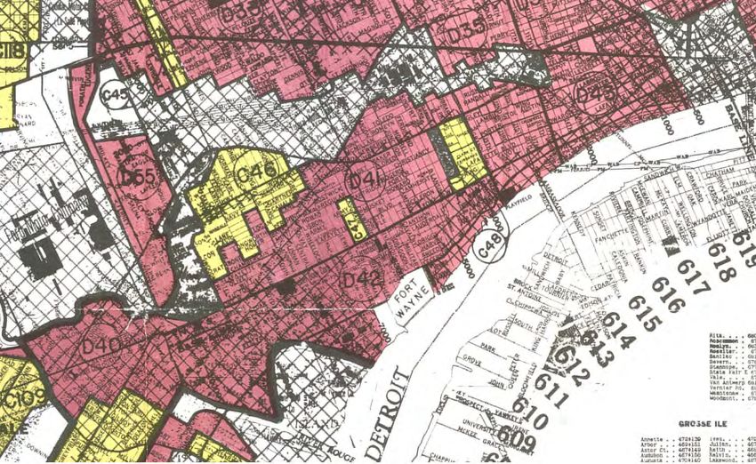
I NTRODUCTION TO GIS            FOR     E QUITY & S OCIAL J USTICE

   Authors:
                                                                              Most of the material in this
   Nicole Franklin & Greg Babinski                                            presentation was extracted
                                                                              the URISA-certified
   URISA review teams:
                                                                              Introduction to GIS for ESJ
   • Mark Salling & Vero Velez (2019)                                         workshop.
   • Matt Gerike (2020)

   Additional review & contributions:
   • Mary Ullrich, King County GIS Center
   • Patrick Jankanish, King County GIS Center
   • Mike Leathers, King County GIS Center
   • Warren Kagarise, King County Information Technology Digital Engagement
   • Jennifer Schmidt, Herrera Engineers, Seattle
   • Vero Velez, Western Washington University
   • Hackman Consulting Group
   • Aline Moch, UW Evans School
   • Royal Alley-Barnes, King County
   • Keith Clarke, King County HR
   • Patrice Frank, King County IT
                                                                                                    3
   • American Geographical Society – EthicalGEO Fellowship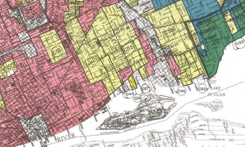
I NTRODUCTION TO GIS              FOR    E QUITY & S OCIAL J USTICE

Workshop Author & Instructor Bios:
Nicole D. Franklin helped develop this workshop as the Chief Equity Officer for King County IT. She develops
workable, pragmatic solutions to technology access problems faced by underserved communities. She served as
the chief equity officer for the Department of Information Technology, where she led efforts to ensure social
justice and equity in her workplace and community. She previously managed the department’s data center for
two years and served as administrator of the organization’s enterprise business continuity program. She piloted a
version of performance management with ESRI with the goal of determining whether current equity actions are
changing desired outcomes. She holds a master’s degree in demography from the University of Pennsylvania and
bachelor degrees in computational and applied mathematics; sociology; and statistics from the University of
Washington. Currently Nicole serves as the Chief Technology Office for the King County Prosecuting Attorney
Office.
Greg Babinski is Marketing Manager for the King County GIS Center in Seattle, where he has worked since
1998. Previously he worked for nine years as GIS Mapping Supervisor for the East Bay Municipal Utility District
in Oakland. He holds an MA in geography from Wayne State University. Greg is a GISP – Certified GIS
Professional. Babinski is Past-President of URISA and founder and Past-Chair of URISA’s GIS Management
Institute. In 2005 he founded The Summit – the Washington State GIS Newsletter. In 2019 Greg was awarded an
EthicalGEO Fellowship by the American Geographical Society. In addition to GIS consulting, he is a GIS
researcher, author, and instructor. He has spoken about GIS management across North America, Europe, Asia
and Australia. Greg has taught GIS for Public Policy as an instructor with the University of Washington Evans
Graduate School of Public Administration. In his spare time Greg likes hiking steep, narrow and dangerous trails
that lead high above the clouds to awesome views.                                                       4
I NTRODUCTION TO GIS              FOR   E QUITY & S OCIAL J USTICE                   Doomed to failure?

Exercise 2 – Pre-workshop Survey
Read the Law Enforcement Code of Ethics (https://www.theiacp.org/resources/law-
enforcement-code-of-ethics). Can there be 'good cops' and 'bad cops' together in the same
police department? Discuss:
• Based on the Law Enforcement Code of Ethics there shouldn't be good cops and bad cops in the same police
  department since the good cops should stand up and speak out about the bad cops. However, in practice that
  is not the case for many reasons (like qualified immunity).
• Yes. We all have our own social and cultural beliefs, morals, ethics, and biases based on our upbringing and
  other social/environmental factors. Despite the best intentions it is difficult to overcome these. Even
  belonging to the same "culture" like a local police force we can different ideas of right and wrong, or
  different ideas about how to go about enforcing the law/fulfilling everything in that moral code. These
  differences can often manifest themselves in certain actors using unethical means to achieve what they
  consider are the "right" ends.
• Culture of a department would have enormous weight and the wrong forces and influences could absolutely
  drag down the best. That being said, outside of perceived betrayal that could lead to retribution, I do think
  strong personalities could maintain a commitment to justice, minimizing biased decisions, and being self-
  aware as they engage with the public.
• If a 'bad cop' is one who knowingly and routinely violates the code of ethics, then No.
• No
• Yes. Since every cop is an individual they will have different personal beliefs and and not everyone can keep
  those from influencing their decisions. Like any job, there are implicit biases that affect their work.
                                                                                                        5
I NTRODUCTION TO GIS       FOR   E QUITY & S OCIAL J USTICE   Doomed to failure?

Exercise 2 – Pre-workshop Survey

                                                                              6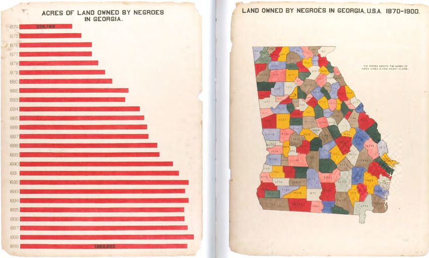
A J OURNEY T OWARDS E QUITY   AND   S OCIAL J USTICE

                                                       7
A J OURNEY T OWARDS E QUITY   AND   S OCIAL J USTICE

                  1619 – Jamestown, Virginia           8
A J OURNEY T OWARDS E QUITY   AND   S OCIAL J USTICE

                                                       9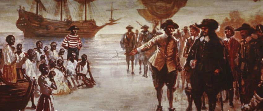
A J OURNEY T OWARDS E QUITY   AND   S OCIAL J USTICE

                                                       10
I NTROD U C T I O N TO GIS F O R E QU I TY & S OC I A L J US TI C E :
W HY GIS F O R E QU I T Y A ND S OC I A L J U S TI C E ?
Geography is one of the most
important assets of any political We lead our lives in time and space.
jurisdiction. It is the ‘platform’ upon
which we live our lives.
11I NTROD U C T I O N TO GIS F O R E QU I TY & S OC I A L J US TI C E :
W HY GIS F O R E QU I T Y A ND S OC I A L J U S TI C E ?
Geography is one of the most
important assets of any political We lead our lives in time and space.
jurisdiction. It is the ‘platform’ upon
which we live our lives.
Cartography and GIS are the
science-based tools to depict the
geography of any location.
12I NTROD U C T I O N TO GIS F O R E QU I TY & S OC I A L J US TI C E :
W HY GIS F O R E QU I T Y A ND S OC I A L J U S TI C E ?
Maps and GIS are based on a simulation of the real world….
1989 - Will Wright creates Sim City
1991 – King County starts developing King County GIS
13I NTROD U C T I O N TO GIS F O R E QU I TY & S OC I A L J US TI C E :
W HY GIS F O R E QU I T Y A ND S OC I A L J U S TI C E ?
Maps, geography, and GIS have been used malevolently in the past
Maps ‘make claims upon the world’ based on
what is included or excluded.
Maps were fundamental to the formation of
modern nation-states, the concept of
citizenship, imperialism, and colonialism.
Surveillant mapping: Top down mapping of
features or phenomena by those in power.
Mapping as a ‘god’s eye view of the state’
Thatcher, J. (2018). Cartography and Power. The Geographic
Information Science & Technology Body of Knowledge (1st Quarter
2018 Edition), John P. Wilson (ed). DOI:
10.22224/gistbok/2018.1.7 14I NTROD U C T I O N TO GIS F O R E QU I TY & S OC I A L J US TI C E :
W HY GIS F O R E QU I T Y A ND S OC I A L J U S TI C E ?
Maps, geography, and GIS have been used malevolently in the past
Organic boundaries
15I NTROD U C T I O N TO GIS F O R E QU I TY & S OC I A L J US TI C E :
W HY GIS F O R E QU I T Y A ND S OC I A L J U S TI C E ?
Maps, geography, and GIS have been used malevolently in the past
Organic spatial patterns
‘How can you buy or sell the sky, the warmth of the land? The idea is strange
to us. If we do not own the freshness of the air and the sparkle of the water,
how can you buy them? Every part of the Earth is sacred to my people. Every
shining pine needle, every sandy shore, every mist in the dark woods, every
clear and humming insect is holy in the memory and experience of my people.
The perfumed flowers are our sisters, the deer, the horse, the great eagle,
these are our brothers. The rocky crests, the juices in the meadows,
16 the body
heat of the pony, and the man, all belong to the same family…’
-Chief Seattle, Suquamish and Duwamish ChiefI NTROD U C T I O N TO GIS F O R E QU I TY & S OC I A L J US TI C E :
W HY GIS F O R E QU I T Y A ND S OC I A L J U S TI C E ?
Maps, geography, and GIS have been used malevolently in the past
Imposed geographic
boundaries 17I NTROD U C T I O N TO GIS F O R E QU I TY & S OC I A L J US TI C E :
W HY GIS F O R E QU I T Y A ND S OC I A L J U S TI C E ?
Maps, geography, and GIS have been used malevolently in the past
Imposed spatial patterns
‘…the old hunger returned —the terrible and obscure hunger that haunts and hurts Americans,
and makes us exiles at home and strangers wherever we go.
Oh, I will go up and down the country and back and forth across the country. I will go out West
where the states are square. I will go to Boise and Helena, Albuquerque and the two Dakotas
and all the unknown places. 18
The rails go westward in the dark…have you heard the roar of the fast express? Have you seen
starlight on the rails?’ -Thomas WolfeI NTROD U C T I O N TO GIS F O R E QU I TY & S OC I A L J US TI C E :
W HY GIS F O R E QU I T Y A ND S OC I A L J U S TI C E ?
Maps, geography, and GIS have been used malevolently in the past
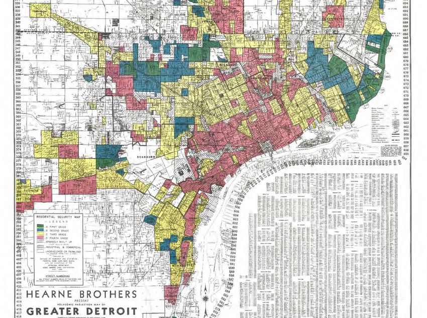
Hidden and unspoken boundaries
https://dsl.richmond.edu/panorama/redlining/
19I NTROD U C T I O N TO GIS F O R E QU I TY & S OC I A L J US TI C E :
W HY GIS F O R E QU I T Y A ND S OC I A L J U S TI C E ?
Maps, geography, and GIS have been used
malevolently in the past
20I NTROD U C T I O N TO GIS F O R E QU I TY & S OC I A L J US TI C E :
W HY GIS F O R E QU I T Y A ND S OC I A L J U S TI C E ?
21I NTROD U C T I O N TO GIS F O R E QU I TY & S OC I A L J US TI C E :
W HY GIS F O R E QU I T Y A ND S OC I A L J U S TI C E ?
22GIS&T B EST P RACTICES FOR E QUITY & S OCIAL J USTICE
23GIS&T B EST P RACTICES FOR E QUITY & S OCIAL J USTICE
24GIS&T B EST P RACTICES FOR E QUITY & S OCIAL J USTICE
25I NTROD U C T I O N TO GIS F O R E QU I TY & S OC I A L J US TI C E :
W HY GIS F O R E QU I T Y A ND S OC I A L J U S TI C E ?
Maps, geography, and GIS are still used malevolently
‘…redistricting is one of the most important applications of GIS technology… Partisan redistricting of our
election districts is implemented with the data and tools we GIS professionals enjoy and celebrate, but in
that application is too often used to deprive us of the truly representative democracy that our constitution
26
intended.’ [Salling 2018]I NTROD U C T I O N TO GIS F O R E QU I TY & S OC I A L J US TI C E :
W HY GIS F O R E QU I T Y A ND S OC I A L J U S TI C E ?
Maps, geography, and
GIS are still used
malevolently
27I NTROD U C T I O N TO GIS F O R E QU I TY & S OC I A L J US TI C E :
W HY GIS F O R E QU I T Y A ND S OC I A L J U S TI C E ?
Maps, geography, and GIS are still used malevolently
GIS&T BOK:
CV-26 - Cartography and Power
28GIS&T B EST P RACTICES FOR E QUITY & S OCIAL J USTICE
Problem statement – why do we need these best practices?
Example…Red-lining maps….but that’s a problem of the past, right?
Wrong!
“Redlining Today: How Racial Bias Continues in Housing”. Dr. Jason Reece, Assistant Professor
in the Knowlton School of Architecture and Michael Outrich, Kirwan Institute Research Associate
discuss racial bias in housing from its origins to the present day. They also highlight real estate
investor grading in neighborhoods and other present day case examples on how racial bias
continues in the real estate and housing industries today.
Carlos Avenancio-Le´on & Troup Howard: ‘The Assessment Gap: Racial Inequalities in Property
Taxation’: http://www.trouphoward.com/uploads/1/2/7/7/127764736/the_assessment_gap_-
_racial_inequalities_in_property_taxation.pdf
Brian Y. An, Anthony Orlando, Seva Rodnyansky: The Physical Legacy of Racism: How Redlining
Cemented the Modern Built Environment. See:
https://www.researchgate.net/publication/337830442_The_Physical_Legacy_of_Racism_How_Redl
ining_Cemented_the_Modern_Built_Environment
29GIS&T B EST P RACTICES FOR E QUITY & S OCIAL J USTICE
Problem statement – why do we need these best practices?
Example…Red-lining maps….but that’s a problem of the past, right?
Wrong!
“Redlining Today: How Racial Bias Continues in Housing”. Dr. Jason Reece, Assistant Professor
in the Knowlton School of Architecture and Michael Outrich, Kirwan Institute Research Associate
discuss racial bias in housing from its origins to the present day. They also highlight real estate
investor grading in neighborhoods and other present day case examples on how racial bias
continues in the real estate and housing industries today.
Carlos Avenancio-Le´on & Troup Howard: ‘The Assessment Gap: Racial Inequalities in Property
Taxation’: http://www.trouphoward.com/uploads/1/2/7/7/127764736/the_assessment_gap_-
_racial_inequalities_in_property_taxation.pdf
Brian Y. An, Anthony Orlando, Seva Rodnyansky: The Physical Legacy of Racism: How Redlining
Cemented the Modern Built Environment. See:
https://www.researchgate.net/publication/337830442_The_Physical_Legacy_of_Racism_How_Redl
ining_Cemented_the_Modern_Built_Environment
https://kingcounty.gov/elected/executive/constantine/news/relea
se/2021/June/23-heat-mapping-results.aspx
30I NTROD U C T I O N TO GIS F O R E QU I TY & S OC I A L J US TI C E :
W HY GIS F O R E QU I T Y A ND S OC I A L J U S TI C E ?
An early example of using maps for social justice:
W.E.B. Du Bois and the Paris Exhibition of 1900
31I NTROD U C T I O N TO GIS F O R E QU I TY & S OC I A L J US TI C E :
W HY GIS F O R E QU I T Y A ND S OC I A L J U S TI C E ?
An early example of using maps for social justice:
W.E.B. Du Bois and the Paris Exhibition of 1900
32I NTROD U C T I O N TO GIS F O R E QU I TY & S OC I A L J US TI C E :
W HY GIS F O R E QU I T Y A ND S OC I A L J U S TI C E ?
An early example of using maps for social
justice: William Bunge, Gwendolyn Warren, and
the Detroit Geographical Expedition
33I NTROD U C T I O N TO GIS F O R E QU I TY & S OC I A L J US TI C E :
W HY GIS F O R E QU I T Y A ND S OC I A L J U S TI C E ?
An early example of using maps for social
justice: William Bunge, Gwendolyn Warren, and
the Detroit Geographical Expedition
34I NTROD U C T I O N TO GIS F O R E QU I TY & S OC I A L J US TI C E :
W HY GIS F O R E QU I T Y A ND S OC I A L J U S TI C E ?
Examples of using maps for social justice:
Native Land: https://native-land.ca/
Aboriginal Mapping Network: http://nativemaps.org/
35I NTROD U C T I O N TO GIS F O R E QU I TY & S OC I A L J US TI C E :
W HY GIS F O R E QU I T Y A ND S OC I A L J U S TI C E ?
Let’s start with ESJ:
Equity: ‘It is an ardent journey toward well-being, and should be defined by those who
are most negatively affected’
Social Justice: ‘….social institutions, when justly organized, provide us with access to
what is good for the person, both individually and in association with others.’
‘Social justice also imposes on each of us a personal responsibility to collaborate with
others, at whatever level of the ‘Common Good’ in which we participate, to design and
continually perfect our institutions as tools for personal and social development.’
The Critical Role of GIS for ESJ:
‘One aspect of social justice is social equity, which is “… the absence of systematic
disparities between groups with different levels of underlying social
advantage/disadvantage — that is, wealth, power, or prestige” In the context of racial
equity it is “… the condition that would be achieved if one’s racial identity no longer
predicted, in a statistical sense, how one fared.’
Geographic analysis via GIS is critical to understand ‘systematic disparities’ and
‘different levels of underlying social advantage/disadvantage’ and a future ‘…condition
that would be achieved if one’s racial identity no longer predicted…how one fared.’
(Citations from Salling et.al 2019)
36I NTROD U C T I O N TO GIS F O R E QU I TY & S OC I A L J US TI C E :
W HY GIS F O R E QU I T Y A ND S OC I A L J U S TI C E ?
Why GIS for Equity and Social Justice now?
There is a long history of using maps and geographic analysis to expose
inequity, but mostly in academia.
URISA pioneered the concept of PPG (Public Participation GIS)
Critical Race Theory provides an academic framework that can be supported by
scientific geospatial analysis
A small number of local agencies are using ESJ analysis to guide high-level
public policy
GIS is critical for ESJ to influence public policy successfully
37I NTROD U C T I O N TO GIS F O R E QU I TY & S OC I A L J US TI C E :
W HY GIS F O R E QU I T Y A ND S OC I A L J U S TI C E ?
We lead our lives in time and
space.
Ron Sims, former KC Executive
and Deputy Secretary of HUD.
‘I had a report from a group called the
Joint Center that had identified that
36% percent of African Americans
under the age of 30 would have
nothing in common with America but
their death.’
KC Demographer Chandler Felt
produced a disturbing report that
demonstrated ‘…our ability to
determine life outcomes such as
lifetime earning of children and cause
of death by zip code with incredible
precision…’
38
https://www.publichealthpost.org/profiles/ron-sims/I NTROD U C T I O N TO GIS F O R E QU I TY & S OC I A L J US TI C E :
W HY GIS F O R E QU I T Y A ND S OC I A L J U S TI C E ?
We lead our lives in
time and space.
Demographics, shocks &
fragility, socio-
economic, and
governance factors are
all related to geography.
Immigrants and
refugees know that
changing their location
can improve their
opportunities in life.
We can advance equity
and social justice by
changing conditions
within our communities. Gates Foundation Goalkeeper Report 2019:
https://www.gatesfoundation.org/goalkeepers/report/2019-report/#ExaminingInequality
39GIS&T B E S T P RAC T I C E S F O R E QU I TY & S OC I A L J US TI C E
https://www.whitehouse.gov/briefing-room/presidential-actions/2021/01/20/executive-order-advancing-
racial-equity-and-support-for-underserved-communities-through-the-federal-government/
40GIS&T B E S T P RAC T I C E S F O R E QU I TY & S OC I A L J US TI C E Section 1. Policy. Equal opportunity is the bedrock of American democracy, and our diversity is one of our country’s greatest strengths. ‘It is therefore the policy of my Administration that the Federal Government should pursue a comprehensive approach to advancing equity for all, including people of color and others who have been historically underserved, marginalized, and adversely affected by persistent poverty and inequality. Affirmatively advancing equity, civil rights, racial justice, and equal opportunity is the responsibility of the whole of our Government. Because advancing equity requires a systematic approach to embedding fairness in decision-making processes, executive departments and agencies (agencies) must recognize and work to redress inequities in their policies and programs that serve as barriers to equal opportunity. Sec. 2. Definitions. For purposes of this order: (a) The term “equity” means the consistent and systematic fair, just, and impartial treatment of all individuals, including individuals who belong to underserved communities that have been denied such treatment, such as Black, Latino, and Indigenous and Native American persons, Asian Americans and Pacific Islanders and other persons of color; members of religious minorities; lesbian, gay, bisexual, transgender, and queer (LGBTQ+) persons; persons with disabilities; persons who live in rural areas; and persons otherwise adversely affected by persistent poverty or inequality. (b) The term “underserved communities” refers to populations sharing a particular characteristic, as well as geographic communities, that have been systematically denied a full opportunity to participate in aspects of economic, social, and civic life, as exemplified by the list in the preceding definition of “equity.” Sec. 4. Identifying Methods to Assess Equity. (a) The Director of the Office of Management and Budget (OMB) shall, in partnership with the heads of agencies, study methods for assessing whether agency policies and actions create or exacerbate barriers to full and equal participation by all eligible individuals. The study should aim to identify the best methods, consistent with applicable law, to assist agencies in assessing equity with respect to race, ethnicity, religion, income, geography, gender identity, sexual orientation, and disability. Sec. 5. Conducting an Equity Assessment in Federal Agencies. Sec. 6. Allocating Federal Resources to Advance Fairness and Opportunity. Sec. 7. Promoting Equitable Delivery of Government Benefits and Equitable Opportunities. Sec. 8. Engagement with Members of Underserved Communities. Sec. 9. Establishing an Equitable Data Working Group. 41
I NTROD U C T I O N TO GIS F O R E QU I TY & S OC I A L J US TI C E :
C RI T I C A L RAC E T HE ORY

  CRT recognizes that racism is engrained in the fabric and system of the American society.
  The individual racist need not exist to note that institutional racism is pervasive in the
  dominant culture. This is the analytical lens that CRT uses in examining existing power
  structures. CRT identifies that these power structures are based on white privilege and
  white supremacy, which perpetuates the marginalization of people of color.
  Elements of CRT:
  • Critique of liberalism
  • Storytelling/counter-storytelling – ‘Naming one’s own reality’
  • Revisionist interpretation of civil rights law
  • White privilege
  • Micro-aggression
  • Applying insights from social science on race/racism to legal questions and policy issues
  • Structural determinism
  • Others….
                                                                                            42
I NTROD U C T I O N TO GIS F O R E QU I TY & S OC I A L J US TI C E :
C RI T I C A L RAC E T HE ORY
https://www.chalkbeat.org/22525
983/map-critical-race-theory-
legislation-teaching-racism
https://www.nytimes.com/interactive/
2019/08/14/magazine/1619-america-
slavery.html
43I NTROD U C T I O N TO GIS F O R E QU I TY & S OC I A L J US TI C E :
C RI T I C A L RAC E T HE ORY
Micro-aggression:
• Microaggression is a manifestation of bullying that employs micro-linguistic
power plays in order to marginalize any target with a subtle manifestation of
intolerance by signifying the concept of "other"
• Race based
• Gender
• Sexuality or sexual orientation
• Ageism
• Mental illness
• Disability abuse
• Optional Exercise 4 – Discuss examples of Micro-aggression
44I NTROD U C T I O N TO GIS F O R E QU I TY & S OC I A L J US TI C E :
P RI NC I P L E S O F E QU I TY A ND S OC I A L J U S TI C E
Equity (Social Equity)
• Social equality vs. social equity
• Social equality = equal access to opportunities and resources
• Social equity = access to opportunities and resources needed to
achieve equal outcomes
45I NTROD U C T I O N TO GIS F O R E QU I TY & S OC I A L J US TI C E :
P RI NC I P L E S O F E QU I TY A ND S OC I A L J U S TI C E
Source: Robert Wood Johnson Foundation 46I NTROD U C T I O N TO GIS F O R E QU I TY & S OC I A L J US TI C E :
P RI NC I P L E S O F E QU I TY A ND S OC I A L J U S TI C E
Equity:
47I NTROD U C T I O N TO GIS F O R E QU I TY & S OC I A L J US TI C E :
P RI NC I P L E S O F E QU I TY A ND S OC I A L J U S TI C E
Social Justice:
• Fair and just relations between individuals and society.
• Social justice can be measured by the explicit and tacit terms for the distribution of
wealth, opportunities for personal activity, and social privileges.
• Social justice assigns rights and duties in the institutions of society, which enables
people to receive the basic benefits and burdens of cooperation. The relevant
institutions often include taxation, social insurance, public health, public school,
public services, labor law and regulation of markets, to ensure fair distribution of
wealth, and equal opportunity.
Our Equity and Social Justice Theory of Change promotes investment in approaches that are pro-
equity and move us upstream and where needs are greatest. Moreover, adopting this theory of
change ensures that our strategies are consistently evaluated based on their equity outcomes, not
just their intent. Ultimately, we seek a course where race and place are eliminated as predictors
of prosperity.
-King County. Equity and Social Justice Strategic Plan: 2016-2022
48I NTROD U C T I O N TO GIS F O R E QU I TY & S OC I A L J US TI C E :
P RI NC I P L E S O F E QU I TY A ND S OC I A L J U S TI C E
Race, ethnicity, and culture
Race: Culture: Ethnicity:
• Skin color • Language • Ancestry
• Physical features • Values • Family of origin
• Socially Constructed • Beliefs • Geographically located
Categories • Traditions
• Food
• Music
• Clothing
• Holidays
• Religion
Source: Hackman Consulting Group 49I NTROD U C T I O N TO GIS F O R E QU I TY & S OC I A L J US TI C E :
P RI NC I P L E S O F E QU I TY A ND S OC I A L J U S TI C E
Diversity, cultural competency, and equity & social justice
Diversity: Cultural Competency: Equity & Social Justice:
• Awareness of difference • Skill development for work • Big picture and daily lives
• Appreciation of difference across cultural lines • Examines systems and history
• Not about access to • Not about access to and how they impact individuals
resources, power, privilege resources, power and • Looks squarely at access to
• Not about systems priviledge resources, power and priviledge
• Not about systems • It is hopeful – a steward of our
best values
Source: Hackman Consulting Group 50I NTROD U C T I O N TO GIS F O R E QU I TY & S OC I A L J US TI C E : P RI NC I P L E S O F E QU I TY A ND S OC I A L J U S TI C E The five racial narratives Source: Hackman Consulting Group 51
I NTROD U C T I O N TO GIS F O R E QU I TY & S OC I A L J US TI C E :
 P RI NC I P L E S O F E QU I TY A ND S OC I A L J U S TI C E
The five racial narratives
White racial narrative                                            Latinx and Arab descent / SW Asian racial narratives

Honest, hard-working, rugged individuals, on time, time           Latinx – “Illegal”, dangerous to the U.S., big families, drugs
trumps relationships, time is money, rational, Christian,         and gangs, criminals, “taking our jobs”, uneducated, work as
good leaders, well educated, civilized, founders of America,      menial labor, rapists, no English, “not from here”, invaders,
charitable, competitive, real Americans, linear, own things,      disease carriers, a threat to our families’ safety, beans and
in charge, “doers”…                                               rice, taking resources from hard-working Americans…

Black racial narrative                                            Arab Descent / SW Asian – Terrorists, violent, Muslim
                                                                  extremists, hate America, “hate our way of life”, hate our
Angry, criminal, drugs and gangs, aggressive, dangerous,          freedom, evil, agents of Satan, abusive to women, backward,
athletes, uneducated, lazy / do not want to work / want to        secretive, exotic, savage, brutal, do not value human life,
live off the system, loud, entertaining, savage, “super-          cannot possibly be a real American…
predators”, abusive, broken families, “underserved”, “at
risk”, complain too much about the past…                          Asian American and Pacific Islander racial narrative

Native American racial narrative                                  (Pre-“model minority”) – Dangerous, shifty, lurking, “yellow
                                                                  menace”, threat to U.S. economy, effeminate men, oversexed
Alcoholics, own casinos, stuck on run down reservations,          women, exotic, “oriental”, spies, martial arts, military threat…
stoic, “closer to nature”, “noble savage”, all dead, caricature
/ mascot, broken English, uneducated / impossible to              (Post-“model minority”) – Smart, good at math and science,
educate, simple, violent, “dances with wolves”, unable to         quiet, submissive, follow the rules, a “model” for other
cope with American society…                                       minorities, don’t make waves, tight families, “do not experience
                                                                  racism because they’re doing so well”, have fully assimilated
                                                                  into America and the “American Dream”, perpetual foreigner…
                                                                                                                        52

                                         Source: Hackman Consulting Group
A J OURNEY T OWARDS E QUITY AND S OCIAL J USTICE
The Five Refusals of White Supremacy, Andrea Gibbons
This article draws on the work of Charles Mills to posit white supremacy as a global political, economic,
and cultural system. Resistance among people of color is, and has always been, widespread. The focus here,
however, is on what Mills (1997: 18) describes as the “epistemology of ignorance” among whites
themselves, serving to preserve a sense of self as decent in the face of privileges dependent upon
obvious injustices against (nonwhite) others. Five themes are identified within a broad and
multidisciplinary range of literature, described here as the “five refusals” of white supremacy. These are
points at which white ignorance must be actively maintained in order to preserve both a sense of the self and
of the wider structures of white privilege and dominance. There is a refusal of the humanity of the other—
and a willingness to allow violence and exploitation to be inflicted. There is a refusal to listen to or
acknowledge the experience of the other—resulting in marginalization and active silencing. There is a
refusal not just to confront long and violent histories of white domination, but to recognize how these
continue to shape injustice into the present. There is a refusal to share space, particularly residential
space, with resulting segregated geographies that perpetuate inequality and insulate white ignorance. Finally
there is a refusal to face structural causes—capitalism as it has intertwined with white supremacy from its
earliest beginnings. To undo one requires the undoing of the others. For each refusal there is a potential
affirmation, presented here in the hope that each might provide an understanding of the breadth of work
required to dismantle white supremacy and of the multiple points for intervention.
53
https://www.researchgate.net/publication/328583504_The_Five_Refusals_of_White_SupremacyI NTROD U C T I O N TO GIS F O R E QU I TY & S OC I A L J US TI C E :
P RI NC I P L E S O F E QU I TY A ND S OC I A L J U S TI C E
How can principles of equity and social justice be
applied to government agencies?
54I NTROD U C T I O N TO GIS F O R E QU I TY & S OC I A L J US TI C E :
H OW U P S T RE A M P OL I C I E S I M PAC T D OW NS TRE A M OUTC OM E S
55I NTROD U C T I O N TO GIS F O R E QU I TY & S OC I A L J US TI C E :
T HE ROL E O F P U BL I C P OL I C Y
King County ESJ Strategic Plan 2016-2020:
https://kingcounty.gov/~/media/elected/executive/equity-social-
56
justice/documents/201607-ESJ-SP-INT-ToC-Strat-VAL.ashx?la=enI NTROD U C T I O N TO GIS F O R E QU I TY & S OC I A L J US TI C E : GIS C O D E O F E T HI C S A ND M O RA L I M P E RATI V E Development of GIS Code of Ethics GIS Code of Ethics: https://www.urisa.org/clientuploads/directory/Documents/CodeofEthics.pdf Broad adoption of the GIS Code of Ethics: URISA: Urban and Regional Information Systems Association GISCI: GIS Certification Institute NSGIC: National States Geographical Information Council AAG: Association of American Geographers UCGIS: University Consortium of Geographic Information Science GIS & T BOK: GS-12 Codes of Ethics for geospatial professionals and KE-31 - Professional Certification 57
I NTROD U C T I O N TO GIS F O R E QU I TY & S OC I A L J US TI C E :
GIS C O D E O F E T HI C S A ND M O RA L I M P E RATI V E

   GIS Code of Ethics (extract):
   https://www.urisa.org/clientuploads/directory/Documents/CodeofEthics.pdf
   I. Obligations to Society
      The GIS professional recognizes the impact of his or her work on society as a
      whole, on subgroups of society including geographic or demographic minorities,
      on future generations, and inclusive of social, economic, environmental, or
      technical fields of endeavor. Obligations to society shall be paramount when
      there is conflict with other obligations.
      1) Do the Best Work Possible, 2) Contribute to the Community to the Extent
      Possible, Feasible, and Advisable, 3) Speak Out About Issues
   II. Obligations to Employers and Funders
   III. Obligations to Colleagues and the Profession
   IV. Obligations to Individuals in Society

                                                                                       58
I NTROD U C T I O N TO GIS F O R E QU I TY & S OC I A L J US TI C E :
GIS C O D E O F E T HI C S A ND M O RA L I M P E RATI V E
Additional Ethics Education for GIS Professionals
www.gisprofessionalethics.org
Case Studies
GIS Code of Ethics & Rules of Conduct
ASPRS Code of Ethics
Syllabi
Practitioner Interview Protocols
Open Forum on Participatory GIS (http://www.ppgis.net/)
59I NTROD U C T I O N TO GIS F O R E QU I TY & S OC I A L J US TI C E : GIS C O D E O F E T HI C S A ND M O RA L I M P E RATI V E What is a ‘moral imperative’ or ‘moral ideal’ and how does it apply to the GIS profession? A moral imperative is a strongly-felt principle that compels that person to act. Former Washington State Governor Gary Locke and Angel Gurria, OECD Secretary General defined a moral imperative related to global economic development in 2010 (https://www.huffpost.com/entry/a-global-economic- and-mor_b_388009) David DiBiase’s introduced the concept of a GIS moral imperative in 2012, writing… Darrell Pugh, the author so often cited for his checklist of the defining traits of professions, includes one he calls a "social ideal." For Michael Davis, serving a shared "moral ideal" is a defining characteristic of all professions. Physician and ethicist John W. Lewis argues that a profession's "core product and service is [its] pledge to put the interests of others ahead of [its] own while providing [its] specific services." At the 2012 Esri Partner Conference, Jack Dangermond reminded attendees "we have a driving purpose to make a difference in the world.“ DiBiase described things GIS professionals can to strengthen their profession, including: Be able to explain the GIS Code of Ethics Volunteer for GIS activities that benefit society Articulate a ‘moral ideal’ for GIS. David DiBiase’s proposed moral ideal: The GIS profession's moral ideal is to apply geospatial technologies and spatial thinking to design sustainable futures for people and places everywhere. Greg Babinski’s Moral Imperative: The GIS profession uses geographic theory, spatial analysis, and geospatial technology to help society manage the Earth’s finite space, with its natural resources and communities, on a just and sustainable basis for the benefit of humanity. 60
I NTROD U C T I O N TO GIS F O R E QU I TY & S OC I A L J US TI C E :
T HE ROL E O F GIS P ROF E S S I ON A L S
    The role of GIS professionals (related to ESJ)…
    • Work with ESJ practitioners
    • Academic research related to ESJ
    • Critical review of ESJ spatial analysis
    • Guide peers and ESJ practitioners by developing and using GIS for ESJ standards,
      and best practices
    • Make ESJ work easy and lean by curating best appropriate data and methodologies
    • Submit your work for critical review of spatial analysis by ESJ practitioners and peer
      GIS professionals
    • Successful ESJ work requires a multi-disciplinary approach
    • Be champions of the use of GIS to uncover the repressed spatial narratives
    • GIS professionals can help support community outreach/education related to ESJ
    • Guard against ESJ ‘Science Deniers’ - How do GIS professionals guard against
      ‘alternate facts’?
    • Do work that is open, transparent, repeatable, and trusted
    • Aren’t we all GIS for ESJ practitioners?
    • Others…?
                                                                                               61
I NTROD U C T I O N TO GIS F O R E QU I TY & S OC I A L J US TI C E :
C RI T I C A L RAC E S PAT I A L A N A LYS I S
62I NTROD U C T I O N TO GIS F O R E QU I TY & S OC I A L J US TI C E :
C RI T I C A L RAC E S PAT I A L A N A LYS I S
Challenges:
How do we define the hidden boundaries that perpetuate inequity?
We have tools to map variance in income, how do we map variance in power
and opportunity?
How do we identify and challenge social spaces that institutionalize inequity?
Goal:
How do we ‘…critically theorize the relationship between space and race,
particularly the role of ‘the map’ in this process, and develop a
methodological approach to the study of space and mapmaking that could be
rightly called an anti-racist practice’?*
Can we ‘…use GIS to tell a counter narrative as an intentional strategy to
challenge racism and other forms of subordination…’*
63
*Velez 2017I NTROD U C T I O N TO GIS F O R E QU I TY & S OC I A L J US TI C E :
C RI T I C A L RAC E S PAT I A L A N A LYS I S
Hidden and not-so hidden past color-lines:*
• In church and school
• On railway cars and on busses
• In hotels and theaters
• In streets and city neighborhoods
• In books and newspapers
• In asylums and jails
• In hospitals and graveyards
• In employment
Persistent color-lines:**
• Continued de-facto school segregation
• De-facto segregated neighborhoods
• Educational tracking
• Gentrification
64
*Du Bois, 1903 **Velez 2017I NTROD U C T I O N TO GIS F O R E QU I TY & S OC I A L J US TI C E :
C RI T I C A L RAC E S PAT I A L A N A LYS I S
Towards a Working Definition of Critical Race Spatial Analysis:*
• Explanatory framework and methodology that accounts for race, racism, and
white supremacy in examining geographic and social spaces
• Works towards challenging racism and white supremacy within space as apart of
challenging all forms of subordination
• Goes beyond description to spatial examine how structural and institutional
factors shape racial dynamics and power
CRSA requires:*
• Foregrounding the color-line
• Challenging race-neutral representations of space
• Mapping the spatial expression of the lived experiences of communities of color
• Investing in spatial research that works for racial justice
• A trans-disciplinary approach
• Emphasizing maps and mapmaking as a tool to analyze socio-spatial
relationships
*Velez 2017 65I NTROD U C T I O N TO GIS F O R E QU I TY & S OC I A L J US TI C E :
H OW GIS A ND M A P S C A N E X P OS E OP P RE S S I ON A ND I NE QUI TY
Equal Justice Initiative – Peace and Justice Project (https://museumandmemorial.eji.org/ )
Confederate monument in
Volunteer Park, Seattle
https://gisandyou.org/2020/06/24/gis-
can-expose-hate-crimes-and-the-
message-of-confederate-civil-war-
monuments/
66I NTROD U C T I O N TO GIS F O R E QU I TY & S OC I A L J US TI C E :
H OW GIS A ND M A P S C A N E X P OS E OP P RE S S I ON A ND I NE QUI TY
Equal Justice Initiative – Peace and Justice Project (https://museumandmemorial.eji.org/ )
Confederate monument in
Volunteer Park, Seattle
https://gisandyou.org/2020/06/24/gis-
can-expose-hate-crimes-and-the-
message-of-confederate-civil-war-
monuments/
67I NTROD U C T I O N TO GIS F O R E QU I TY & S OC I A L J US TI C E :
H OW GIS A ND M A P S C A N E X P OS E OP P RE S S I ON A ND I NE QUI TY
Monroe Work Today (http://www.monroeworktoday.org/)
Six recorded instances of
lynching in King County;
three instances in Pierce
County, Washington
68I NTROD U C T I O N TO GIS F O R E QU I TY & S OC I A L J US TI C E :
H OW GIS A ND M A P S C A N E X P OS E OP P RE S S I ON A ND I NE QUI TY
Anti-Defamation League Hate Crimes Map (https://www.adl.org/adl-hate-crime-map)
69I NTROD U C T I O N TO GIS F O R E QU I TY & S OC I A L J US TI C E :
H OW GIS A ND M A P S C A N E X P OS E OP P RE S S I ON A ND I NE QUI TY
Other examples?
Movement Advancement Project: http://www.lgbtmap.org/equality-
maps/hate_crime_laws
Southern Poverty Law Center Hate Group Map: https://www.splcenter.org/hate-map
The Message of Confederate Civil War Monuments:
https://www.urisa.org/clientuploads/directory/Documents/The%20GIS%20Profession
al/2020/MarchApril_2020.pdf (pp. 12-27)
On why we so often see the Confederate Flag and the Nazi Flag displayed together
(hint – it’s not just a coincidence): Laurence Mordekhai Thomas, Understanding Evil:
American Slavery, the Holocaust, and the Conquest of the American Indians:
https://www.jstor.org/stable/2382066?seq=1
Desmond Ang: The Birth of a Nation: Media and Racial Hate:
https://www.hks.harvard.edu/publications/birth-nation-media-and-racial-hate
70I NTROD U C T I O N TO GIS F O R E QU I TY & S OC I A L J US TI C E :
T HE ROL E O F ESJ P RAC T I T I ONE RS
Who/what are ESJ practitioners?
• Academics focused on ESJ issues
• People who work for agencies focused on ESJ issues
• People who work for agencies or companies that want to apply an equity lens to
their mission
• Residents
• Others…?
• For ESJ to succeed (be achieved?) disciplines, people, & agencies have to work
together
Equity & Social Justice is a Multi-Disciplinary Approach to Apply
Science to Public Policy.
71I NTROD U C T I O N TO GIS F O R E QU I TY & S OC I A L J US TI C E :
T HE ROL E O F ESJ P RAC T I T I ONE RS
The role of ESJ practitioners (related to GIS)…
• Work with GIS professionals or users
• Academic research
• Critical review of spatial analysis, standards, and best practices
• Submit your work for critical review of spatial analysis by GIS
professionals
• Successful ESJ work requires a multi-disciplinary approach
• Guard against ESJ ‘Science Deniers’
• Do work that is open, transparent, repeatable, and trusted
• What is your span of control?
• Aren’t we all ESJ practitioners?
• Others…?
72I NTROD U C T I O N TO GIS F O R E QU I TY & S OC I A L J US TI C E :
B E S T P RAC T I C E S F O R GIS P ROF E S S I ON A L S D O I NG ESJ WORK
Within a typical enterprise GIS operations
there are many use cases with their own
distinct operations, process and
management requirements. 73I NTROD U C T I O N TO GIS F O R E QU I TY & S OC I A L J US TI C E :
A C ONC E P T UAL GIS F O R ESJ L I F E C YC L E
74I NTROD U C T I O N TO GIS F O R E QU I TY & S OC I A L J US TI C E :
B E S T P RAC T I C E S F O R GIS P ROF E S S I ON A L S D O I NG ESJ WORK
What makes a “Best Practice” Best?
Best Practice v. Standards
A best practice is a method or technique that
has been generally accepted as superior to any
alternatives because it produces results that are
superior to those achieved by other means
A standard is an established norm or procedure
for repeatable tasks or a process for doing
things, e.g., a standard way of complying with
legal or ethical requirements.
What is the problem we are trying to solve
with GIS for ESJ ‘Best Practices’?
75I NTROD U C T I O N TO GIS F O R E QU I TY & S OC I A L J US TI C E :
B E S T P RAC T I C E S F O R GIS P ROF E S S I ON A L S D O I NG ESJ WORK
Why pursue “Best Practices”?
• They create a roadmap for doing good ethical work
• They should result in consistent products that can be compared against
alternatives (Same time, same geography, alternate problem approaches)
• They should result in products that can be compared meaningfully over
time (Same problem approach, same geography, different time)
• They should result in products that can be compared meaningfully across
space (Same time, same or alternate approaches, different geography)
• Other benefits of “Best Practices”
• They support efficiency and lean processes
• They enable meaningful critique (by GIS or ESJ professionals)
• Consistent standards support transparency
76I NTROD U C T I O N TO GIS F O R E QU I TY & S OC I A L J US TI C E :
B E S T P RAC T I C E S F O R GIS P ROF E S S I ON A L S D O I NG ESJ WORK
Domains of GIS for ESJ “Best Practices”
A key GIS role is to be the primary resource for ESJ researchers within an
agency for data discovery and guidance related to analysis, mapping, and
cartographic display
1. Definitions
2. Spatial data management
3. Spatial data sources
4. Geospatial analytical practices
5. Cartographic practices
6. General visualization practices
7. Dashboards for geovisualization
77A J OURNEY T OWARDS E QUITY AND S OCIAL J USTICE
Domains of GIS for ESJ “Best Practices”
Part of the exploratory research and analysis
3. Spatial data sources phase process is to develop baseline metrics
H - The equity index and equity indicators analysis and mapping that form the
determinants of equity.
Two approaches to defining baseline metrics:
• Equity index
• Individual determinant of equity.
79I NTROD U C T I O N TO GIS F O R E QU I TY & S OC I A L J US TI C E :
B E S T P RAC T I C E S F O R GIS P ROF E S S I ON A L S D O I NG ESJ WORK
Domains of GIS for ESJ “Best Practices” GIS based dashboards
7. GIS based dashboards for ESJ program
• Role in the GIS for ESJ lifecycle
management
• Dashboards are based on
integrated geovisualization
• Geovisualization is based on an
interactive environment that
supports viewing integrated
spatial, temporal, and attribute
data
• Geovisualization facilitates
visual thinking by synthesizing
a context of known reference
points with a variety of data
sources to help the user reveal
previously unknown conditions
80I NTROD U C T I O N TO GIS F O R E QU I TY & S OC I A L J US TI C E :
B E S T P RAC T I C E S F O R GIS P ROF E S S I ON A L S D O I NG ESJ WORK
Domains of GIS for ESJ “Best Practices”
7. GIS based dashboards for ESJ program
management
81GIS&T B E S T P RAC T I C E S F O R E QU I TY & S OC I A L J US TI C E
Demographic data Base Map(s)
Sources: Equity Data &
ACS, OSPI, Counties, Map Layers
Tribes, SDs, others Users
(WaTech)
State:
Educators,
Asset data Sources: Infrastructure Digital Navigators,
Broadband Office, Assets Data & Funders,
Service Providers, Map Layers Formal Partners
Counties, others (Commerce)
Application
Development:
TBD
Users
Other Jurisdictions:
Educators,
Ongoing I-ACT Funders,
Application & Washington Formal Partners
Data O&M State Digital
Coordination: Equity Action
TBD
Dashboard
Users
Digital Equity Outside Partners:
Generic Foundations,
Data Portal
Washington NGO's,
(Metadata,
State Equity Service Providers
APIs, Map
Dashboard
Services)
Users
Stakeholders:
Navigators,
Educators,
Libraries,
Community,
Researchers
Future Users
I-ACT Stakeholders
for individual
Washington State Digital Equity Action Dashboard future
Draft Use Case Diagram dashboards
developed
Draft: gb – Rev. 11/2/2020
within the
82
generic equity
dashboardGIS&T B E S T P RAC T I C E S F O R E QU I TY & S OC I A L J US TI C E
83GIS&T B EST P RACTICES FOR E QUITY & S OCIAL J USTICE
The Community Participation Plan
In GIS we work within a simulation of reality.
How do we know that our simulation
corresponds to the lived reality of members of
the community?
Critical race spatial analysis requires that we
acknowledge the limitations of what GIS data
and analysis can tell us about the real world
and that we make an effort to mitigate those
limitations.
William Bunge (with Gwendolyn Warren)
recognized this with the Detroit Geographical
Expedition of the early 1970s
84GIS&T B EST P RACTICES FOR E QUITY & S OCIAL J USTICE The
Community
Participation
A possible approach to use community
Plan
participation plan input to have a meaningful
impact on GIS work
Typical GIS Scope of Work: Proposed CPP Scope of Work:
1. Project Management 1. Project Management
2. Administrative Needs Assessment and 2. Identify/finalize the communities to be included
Requirement in the CPP
3. Conceptual Design 3. Conduct individual Community Participation
4. Architectural Design Sessions.
a) System Architecture 4. Analyze and report on information compiled
b) Data Architecture from all sessions. This task will develop the CPP
5. Detailed Design Final Report.
6. Design Development
7. Testing & Implementation
8. Customer Acceptance
85GIS&T B EST P RACTICES FOR E QUITY & S OCIAL J USTICE
The Community Participation Plan
86
Zachman Framework for Enterprise ArchitectureGIS&T B EST P RACTICES FOR E QUITY & S OCIAL J USTICE The
Community
A possible approach to use community Participation
participation plan input to have a meaningful
impact on GIS work Plan
Typical GIS Scope of Work:
1. Project Management
2. Administrative Needs Assessment and
Requirements Proposed CPP Scope of Work:
…. 1. Project Management
…. 2. Identify/finalize the communities to be included
…. in the CPP
…. 3. Conduct individual Community Participation
…. Sessions.
…. 4. Analyze and report on information compiled
3. Conceptual Design from all sessions. This task will develop the CPP
…. Final Report.
4. Architectural Design
a) System Architecture
b) Data Architecture
….
5. Detailed Design
….
….
….
….
6. Design Development
7. Testing & Implementation
8. Customer Acceptance
87I NTROD U C T I O N TO GIS F O R E QU I TY & S OC I A L J US TI C E :
H OW GIS C A N BE U S E D TO M A N AG E A ND M O NI TOR P RO - E QUI TY P OL I C I E S
How is this different than other GIS standards and best practices?
• For ESJ programs to have meaningful results, long-term management and monitoring
is required
• Long-term management, monitoring, and analysis of ESJ programs requires…
• Consistent data, processes, and methodologies
• Cross-agency cooperation
• Multi-program monitoring
• Multi-year analysis
Development of GIS for ESJ Best Practices:
• Supported by American Geographical Society EthicalGEO Fellowship (https://ethicalgeo.org/)
• Full document aailable for download now at: https://ethicalgeo.org/greg-babinski/
• Two new GIS & T BOK topics published May 2021:
• GS-27 GIS for Equity & Social Justice
• KE-19 Managing GIS Infrastructure & Operations
88I NTROD U C T I O N TO GIS F O R E QU I TY & S OC I A L J US TI C E :
E X A M P L E S O F P U BL I C AG E NC I E S W I TH ESJ P OL I C Y P RI ORI T I E S
Among major U.S. cities, some notable examples
include:
• Seattle, Washington’s Race and Social Justice
Initiative (https:// www.seattle.gov/rsji)
• Madison, Wisconsin’s Racial Justice and Social
Equity Initiative
(https://www.cityofmadison.com/civil-
rights/programs/racialequity-social-justice-
initiative)
• Portland, Oregon’s Office of Equity and Human
Rights (https:// www.portlandoregon.gov/oehr/)
• Austin, Texas’ Equity Office
(http://www.austintexas.gov/department/equity
-office)
89I NTROD U C T I O N TO GIS F O R E QU I TY & S OC I A L J US TI C E :
E X A M P L E S O F P U BL I C AG E NC I E S W I TH ESJ P OL I C Y P RI ORI T I E S
• King County, Washington’s Equity and Social
Justice Priority Initiative
(https://www.kingcounty.gov/elected/executive/e
quity-social-justice.aspx)
• Kent County, Michigan’s Health Equity and Social
Justice program
(https://www.accesskent.com/Health/HealthPromo
/health_equity.htm)
• Minnesota Health Department’s Racial Equity and
Social Justice Tool
(http://www.health.state.mn.us/divs/opi/healtheq
uity/resources/madison-justice.html)
• Portland, Oregon Public School’s Racial Equity and
Social Justice Program
(https://www.pps.net/domain/51)
• DeAnza College’s Office of Equity, Social Justice
and Multicultural Education
(https://www.deanza.edu/equityoffice/)
• Western Washington University’s Education and
Social Justice minor program
(https://wce.wwu.edu/esj)
90I NTROD U C T I O N TO GIS F O R E QU I TY & S OC I A L J US TI C E :
E D U C AT I O N A L RE S OU RC E S F O R GIS P ROF E S S I ON A L S
• This workshop and look for future refinements and spin-off specialty
training
• WWU ESJ Minor: https://wce.wwu.edu/esj
• Hackman Consulting Group: https://hackmanconsultinggroup.org/
Resource for employees of local and regional government agencies:
• Local and Regional Government Alliance on Race & Equity:
https://www.racialequityalliance.org/
GIS for ESJ groups:
• LinkedIn GIS for ESJ group: https://www.linkedin.com/groups/13745942/
• Esri GIS for ESJ Community Group: https://community.esri.com/content
91I NTROD U C T I O N TO GIS F O R E QU I TY & S OC I A L J US TI C E :
E D U C AT I O N A L RE S OU RC E S F O R GIS P ROF E S S I ON A L S
WWU ESJ Minor: https://wce.wwu.edu/esj Hackman Consulting Group:
https://hackmanconsultinggroup.org/
The Kirwan Institute for the Study of Race and
Ethnicity: http://kirwaninstitute.osu.edu/
Aboriginal Mapping Network:
http://nativemaps.org/
92I NTROD U C T I O N TO GIS F O R E QU I TY & S OC I A L J US TI C E : T HE URISA GIS F O R ESJ S P E C I A L W ORK G RO UP GIS for ESJ Workgroup The URISA Equity and Social Justice Workgroup will work to develop educational materials Activities: • Evolving – You can help decide! Membership: • Any interested URISA member Chair and contact: • Judy Colby-George, GISP: jcg@spatialalternatives.com URISA Pro-Equity, Anti-Racism Committee Activities: • Evolving – You can help decide! Membership: • Interested and committed URISA members Chairs and contact: • Nicole Franklin & Greg Babinski; Sophia Garcia & Victoria Beckley 93
I NTROD U C T I O N TO GIS F O R E QU I TY & S OC I A L J US TI C E :
S U G G E S T E D R E A D I NG S
  Harris, Cheryl I. (1993). Whiteness as Property. Harvard Law Review, Vol. 106, No. 8 (June 1993) pp. 1707-1791. Http://www.jstor.org/stable/1341787.
  Knudson, C. Detroit, Geographical, Expedition, Institute: Unpacking the History and Structure of the DGEI. Antipodes. 2017. Accessed April 17, 2020 at:
  https://antipodeonline.org/wp-content/uploads/2017/02/dgei-field-notes_chris-knudson.pdf.
  Rambaldi, Giacomo, Who Owns the Map Legend?, URISA Journal, Vol. 17, No. 2, Urban and Regional Information Systems Association, 2005
  Joshua F. J. Inwood & Anne Bonds (2017): Property and whiteness: the Oregon standoff and the contradictions of the U.S. Settler State, Space and Polity,
  DOI:10.1080/13562576.2017.1373425
  Anne Bonds(2013): Economic Development, Racialization, and Privilege: “Yes in My Backyard” Prison Politics and the Reinvention of Madras, Oregon, Annals of
  the Association of American Geographers, DOI:10.1080/00045608.2013.779549
  Andrea Gibbons, The Five Refusals of White Supremacy, 2018, American Journal of Economics and Sociology
  (https://www.academia.edu/37670328/The_Five_Refusals_of_White_Supremacy?email_work_card=reading-history)

  Nazism and its reliance on Jim Crow and American Racism: https://www.ushmm.org/collections/bibliography/nazism-and-the-jim-crow-south
  Jamesn Q. Whitman, American Model: The United States and the Making of Nazi Race Law, Princeton University Press, see:
  https://www.law.nyu.edu/sites/default/files/upload_documents/Hitler%27s%20American%20Model%20for%20NYU.pdf.

                                                                                                                                                       94
I NTROD U C T I O N TO GIS F O R E QU I TY & S OC I A L J US TI C E :
B I BL I OG RA P HY & A C KNOW L E D G E ME NTS
Bibliography:
Battle-Baptiste, W. and Rusert, B., editors. W.E.B. Du Bois’s Data Portraits: Visualizing Black America (The Color Line at the Turn of the
Twentieth Century). New York: Princeton Architectural Press, 2018.
Morrison, Deb, Annamma, S.A., and Jackson, D., editors. Critical Race Spatial Analysis: Mapping to Understand and Address
Educational Inequity. Sterling, VA: Stylus, 2017.
Salling, M., Boundaries that Matter: Partisan Gerrymandering of U.S. Congressional Districts, The GIS Professional, Issue 287,
January/February 2019.
Salling, M., Babinski, G., and Franklin, N. The Role of the GIS Professional in Issues of Equity and Social Justice, The GIS
Professional, Issue 281, January/February 2018.
Tobias, Terry N. Chief Kerry’s Moose: A Guidebook to Land Use and Occupancy Mapping, Research Design and Data Collection.
Vancouver, Canada: Union of BC Indian Chiefs and Ecotrust Canada (co-publishers), 2000.
Bunge, William. Fitzgerald: Geography of a Revolution (With an Introduction by Nick Heynen and Trevor Barnes. Originally published
by Shenkman Publishing Company, 1971. Athens, Georgia: University of Georgia Press, 2011.
King County. Equity and Social Justice Strategic Plan: 2016-2022. Office of Equity and Social Justice, Office of King County Executive
Dow Constantine, Seattle, 2016.
Acknowledgements:
Mary Ullrich, Patrick Jankanish, and Mike Leathers from the King County GIS Center provided insights and advice regarding GIS for
ESJ best practices.
Jennifer Schmidt, Herrera Engineers
Vero Velez, Western Washington University
Hackman Consulting Group
Aline Moch, UW Evans School of Public Administration, Policy Brief: Creative Economy in Seattle, Washington
(https://www.arcgis.com/apps/MapJournal/index.html?appid=fed5e076356d4d2292adcd984c71e383)
95You can also read