GNGTS 2018 - Istituto Nazionale di Oceanografia e di Geofisica ...
←
→
Page content transcription
If your browser does not render page correctly, please read the page content below
GNGTS 2018
GNGTS 2018

                     sessione 2.1

Pericolosità da terremoti e maremoti

            Convenor: D. Di Bucci e D. Albarello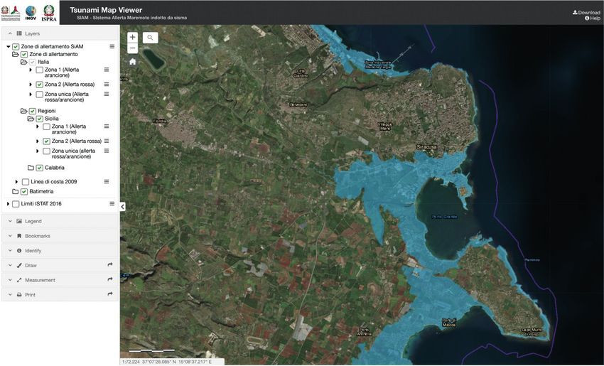
GNGTS 2018 Sessione 2.1
MAXIMUM INUNDATION WAVE HEIGHT BY TSUNAMIS FROM EARTHQUAKE
AND LANDSLIDE SOURCES: A DISCUSSION ON METHODOLOGICAL ASPECTS
A. Armigliato1, G. Pagnoni1, M.A. Paparo1, F. Zaniboni1, S. Lorito2, F. Romano2, M. Volpe2, R. Basili2,
S. Tinti1
1
Dipartimento di Fisica e Astronomia, Alma Mater Studiorum - Università di Bologna, Italy
2
Istituto Nazionale di Geofisica e Vulcanologia (INGV), Roma, Italy
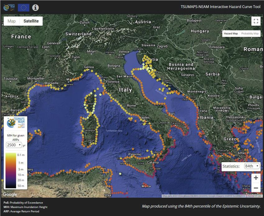
Italian peninsula a hazard to be seriously taken into account. This is also confirmed by
recent hazard assessments such as TSUMAPS-NEAM (http://www.tsumaps-neam.eu/).
Hazard assessment requires a well-structured approach including: 1) the identification and
characterization of the sources that can have the potential to generate tsunamis in the future,
2) the availability of detailed and reliable topo-bathymetric datasets, 3) the development
and application of suitable methodologies to quantify the physical observables relevant for
both scientific and civil protection purposes, and 4) a properly defined strategy to assess the
uncertainties to be associated to the final results (e.g. Selva et al., 2016). Particularly as far as
the tsunami inundation phase is concerned, the definition of the most appropriate methodology,
which may include both numerical models, solving the equations describing the physics of the
phenomenon, and simplified empirical or semi-empirical approaches is a matter of debate in
the international and national communities involved in tsunami research (e.g. Løvholt et al.,
2012; Lorito et al., 2015; Gailler et al., 2018). This paper represents a joint effort to tackle
some aspects of the problem in a harmonized way and to find the answers to a number of
questions which are not only relevant from the scientific point of view but may also have
decisive implications for vulnerability and risk assessment, land planning and civil protection.
The occasion for starting such a discussion was the “SPOT” project (Sismicità Potenzialmente
innescabile Offshore e Tsunami; Di Bucci et al., 2017), financed by the Italian “Ministero
dello Sviluppo Economico” (MISE). One of the main goals of the project was to quantify the
maximum wave elevation expected along the whole Italian coastline for tsunamis generated
by both selected tectonic (earthquakes) and landslide sources. The computation of detailed
inundation maps for the entire Italian coastline is a prohibitive task that, in case of unavailable
high-resolution topo-bathymetric models, and of limited financial and computational resources,
implies the adoption of simplified but still rigorous approaches. The main question that we
try to find an answer to is: can a “standardized” methodology be developed, applicable to any
tsunamigenic source and target coastal area, or must we proceed in a case-by-case perspective?
This contribution is a snapshot of a work in progress that, so far, led to the agreed adoption of
the following methodology.
1. A reference bathymetric dataset and a reference coastline is selected: we chose the most
recent version of the EMODnet (2018) database and of the ISTAT (2015) coastline.
2. As regards tsunami generation, the Okada (1992) formulae are used to compute the
tsunami initial condition in the case of earthquakes, while the Lagrangian model UBO-
BLOCK (see Tinti et al., 1997; Zaniboni et al., 2016 for a detailed description) is applied
to compute landslide dynamics and associated tsunami excitation.
3. Well-established and benchmarked numerical models solving the Navier-Stokes equations
in the shallow-water approximation are used to compute the tsunami propagation from
the source to a given reference bathymetric isoline in the nearshore region (e.g Tsunami-
HySEA, Macías et al., 2017).
4. The simulations are carried out over computational grids with spatial resolutions suitable
for wavelengths typical of earthquake- and landslide-generated tsunamis, which may
differ from case to case.
5. The amplification of the tsunami waves from the selected bathymetric isoline up to the
coastline is calculated by means of the Green’s law: for this purpose, the coastline is
assigned a reference depth of 1 m.
5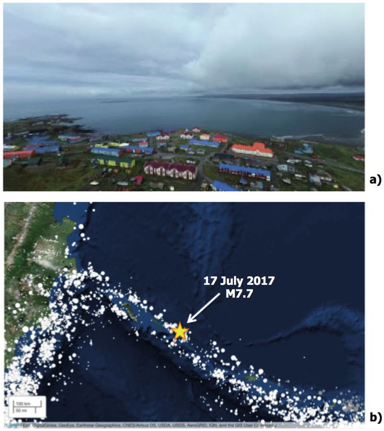
GNGTS 2018                                                                                                     Sessione 2.1

   6. The inundation process is simulated by applying a modified version of the “energy
       method” proposed by Kriebel et al. (2017), allowing for the reconstruction of maximum
       inundation depths along preselected onshore transects, starting from the wave height at
       the coastline.
   In this paper we show and discuss the application of the above methodology to the area of
the Gulf of Gela (southern Sicily), where a significant hazard exists for tsunamis generated by
both earthquakes and landslides.
References
Di Bucci D., Antoncecchi I., Ciccone F., Teofilo G., Terlizzese F., Argnani A., Ligi M., Rovere M., Basili R., Coltelli M.,
     Lorito S., Borzi B., Germagnoli F., Di Ludovico M., Lignola G.P., Prota A.; 2017: The SPOT project (potentially
     triggerable offshore seismicity and tsunamis): a first appraisal of the possible impact of oil and gas platforms on
     the seismic and tsunami risks along the Italian coasts. Geoingegneria Ambientale e Mineraria, 152, 3, 132-138.
EMODnet Bathymetry Consortium; 2018: EMODnet Digital Bathymetry (DTM). DOI 10.12770/18ff0d48-b203-
     4a65-94a9-5fd8b0ec35f6.
Gailler A, Hébert H, Schindelé F, Reymond D (2018) Coastal amplification laws for the french tsunami warning
     center: Numerical modeling and fast estimate of tsunami wave heights along the French riviera. Pure and Applied
     Geophysics 175(4):1429–1444, DOI 10.1007/s00024-017-1713-9.
Istituto Nazionale di Statistica (ISTAT); 2015: Sezioni di censimento litoranee. https://www.istat.it/it/archivio/137341.
Kriebel D. L., Lynett P. J., Cox D. T., Petroff C. M., Robertson I. N. and Chock G. Y. K.; 2017: Energy method for
     approximating energy overland tsunami flows. J. Waterway, Port, Coastal, Ocean Eng., 143(5), DOI 10.1061/
     (ASCE)WW.1943-5460.0000393.
Lorito S, Selva J, Basili R, Romano F, Tiberti M, Piatanesi A (2014) Probabilistic hazard for seismically induced
     tsunamis: accu- racy and feasibility of inundation maps. Geophysical Journal International 200(1):574–588, DOI
     10.1093/gji/ggu408.
Løvholt F, Glimsdal S, Harbitz CB, Zamora N, Nadim F, Peduzzi P, Dao H, Smebye H (2012) Tsunami hazard and
     exposure on the global scale. Earth- Science Reviews 110(1):58 – 73, DOI 10.1016/j.earscirev. 2011.10.002.
Macías J, Castro MJ, Ortega S, Escalante C, González-Vida JM (2017) Per- formance benchmarking of tsunami-hysea
     model for NTHMP’s inundation mapping activities. Pure and Applied Geophysics 174(8):3147–3183, DOI 10.
     1007/s00024-017-1583-1.
Okada Y.; 1992: Internal deformation due to shear and tensile faults in a half-space. Bull. Seism. Soc. Am., 82(2),
     1018-1040.
Selva J, Tonini R, Molinari I, Tiberti MM, Romano F, Grezio A, Melini D, Piatanesi A, Basili R, Lorito S (2016)
     Quantification of source uncertainties in Seismic Probabilistic Tsunami Hazard Analysis (SPTHA). Geophysical
     Journal International 205:1780–1803, doi:10.1093/gji/ggw107.
Tinti S., Bortolucci E. and Vannini C.; 1997: A block-based theoretical model suited to gravitational sliding. Nat
     Hazards, 16, 1–28.
Tinti S. and Tonini R.; 2013: The UBO-TSUFD tsunami inundation model: validation and application to a tsunami
     case study focused on the city of Catania, Italy. Nat. Hazards Earth Syst. Sci., 13, 1795–1816.
Zaniboni F., Armigliato A. and Tinti S.; 2016: A numerical investigation of the 1783 landslide-induced catastrophic
     tsunami in Scilla, Italy. Nat Hazards, 84, S455–S470.

PRELIMINARY NUMERICAL SIMULATIONS OF THE 28 SEPTEMBER 2018
TSUNAMI IN SULAWESI (INDONESIA)
A. Armigliato, E. Baglione, G. Pagnoni, M. A. Paparo, S. Tinti, F. Zaniboni
Dipartimento di Fisica e Astronomia, Alma Mater Studiorum – Università di Bologna, Italy

   On 28 September 2018 at 10:02 UTC an earthquake of magnitude 7.5 struck the island
of Sulawesi (Indonesia). The earthquake, whose epicentre was located about 78 km north of
the city of Palu, was characterized by a prevailing strike-skip faulting mechanism. According
to the results available at the USGS web site (https://earthquake.usgs.gov/earthquakes/
eventpage/us1000h3p4/executive), the region of maximum ground shaking is elongated in the
6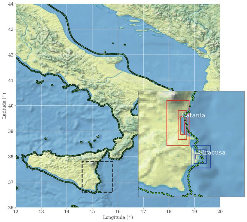
GNGTS 2018                                                                              Sessione 2.1

N-S direction, from the epicentre to the north down to several tens of kilometres south of the
city of Palu. The shaking was responsible for huge and diffuse liquefaction and landslides,
but the most devastating phenomenon following the earthquake was a huge tsunami, whose
effects were much worse than what could be expected on the basis of the magnitude and of
the focal mechanism determination, and which contributed to increase dramatically the level
of damage and the number of fatalities. The tsunami was destructive especially inside the bay
of Palu, an approximately 30-km long and 6-km wide narrow basin elongated along the N-S
direction and with steep bathymetric gradients and maximum depths in the order of 700-800
m. The tsunami impact in different places along the bay of Palu coasts was documented by
a large number of videos and reports broadcasted by eye-witnesses over the social networks
and successively made available in the web. The destruction documented live over the social
networks was in jarring contrast with the performance of the Indonesia Tsunami Early Warning
System (InaTEWS): although a warning was issued timely (5 minutes after the earthquake),
the combination of the short time interval between the earthquake onset and the arrival of
the first tsunami wave, of the underestimation of the expected maximum run-ups, and of the
poor efficiency of the downstream communications resulted in a very large number of victims.
Moreover, the warning was lifted after about 30 minutes, when a 6-cm amplitude was observed
at the tide-gauge of Mamuju (very far from the Palu bay), leading to the wrong evaluation of
the tsunami evolution. At the end, more than 2100 fatalities were counted in total in the whole
Sulawesi island and more than 600 people are missing, although it is still not clear whether it is
possible to separate those caused by the earthquake from those due to the tsunami.
    From the instrumental point of view, the tsunami was clearly detected only by three tide-
gauge stations. Two of them (Bitung and Mamuju) are very far from the epicentral area and
from the bay of Palu: the detected sea level anomalies are in the order of few centimetres
peak-to-peak. Instead, the tide-gauge of Pantoloan is placed inside the bay of Palu, along its
north-eastern coast. The record from this sensor shows a clear first negative movement of the
sea occurring 5 minutes after the earthquake, followed by a positive peak of approximately the
same amplitude: the peak-to-peak amplitude results in 3.8 m and an estimate of the characteristic
period is 6 minutes. Three other wave packets of gradually decreasing, but still relevant (> 1 m)
peak-to-peak amplitude are observed during the first hour: the oscillations then continue more
or less for other 4 hours.
    Post-event field surveys have been carried out along the coasts of the Palu bay by an
Indonesian team and by a Japanese team in the very first days of October 2018. Other surveys
involving international tsunami researchers, including also one of the authors of this paper, are
planned to be carried out in November. For the city of Palu, the Japanese team (see Muhari et
al., 2018) reported maximum inundation distances in the order of some hundreds of meters and
maximum flow-depths locally larger than 9 m. Along the eastern coastline of the bay, flow-
depths decrease from south (4.8 m in Marboro) to north (1.9 m north of Pantoloan).
    A rather detailed picture of the inundation distance along the coastal areas of the Palu bay
can be deduced also through the comparison of satellite images captured shortly before and
shortly after the tsunami (e.g. http://emergency.copernicus.eu/mapping/list-of-components/
EMSR317/ALL/EMSR317_07PALU) .
    This presentation provides some preliminary results regarding the numerical simulation of
the tsunami. We investigate the complexity of the phenomenon and its unexpected features by
taking into account two possible generation mechanisms. The first is obviously the earthquake,
for which some detailed finite-fault models are made available over the internet (see for
instance https://earthquake.usgs.gov/earthquakes/eventpage/us1000h3p4/finite-fault). We start
from the available fault geometries and heterogeneous slip distributions/rupture mechanisms
over the fault to simulate the tsunami initial conditions by means of the Okada (1992) analytical
formulae. Secondly, we formulate hypotheses on possible landslides triggered by the seismic
shaking by carefully digitizing and analysing some detailed bathymetric maps of the bay, taking
                                                                                                  7
GNGTS 2018                                                                                              Sessione 2.1

also into account some observed collapse phenomena involving coastal structures such as piers.
The landslide dynamics is simulated with the aid of the UBO-BLOCK Lagrangian model (e.g.
Tinti et al., 1997; Zaniboni et al., 2016). For each reconstructed source, the propagation and
impact of the ensuing tsunami is modelled by means of the UBO-TSUFD numerical code (Tinti
and Tonini, 2013) solving the non-dispersive shallow-water equations. Our results are provided
in terms of maximum water elevations over the entire Palu bay and of water elevation time
series in selected coastal points. We discuss the capability of each scenario to reproduce the
available information on tsunami inundation distances and flow depths in different sectors of
the bay, and to match the marigram recorded by the Pantoloan tide gauge.
References
Muhari A., Imamura F., Arikawa T. and Aftiyanto B.; 2018: Finding of the unexpected tsunami due to strike-slip fault
    at central Sulawesi, Indonesia on 28 September 2018, from the preliminary field survey at Palu (available at
    http://itic.ioc-unesco.org/images/stories/itst_tsunami_survey/itst_palu/IRIDeS_report_Palu_survey_20181015.
    pdf).
Okada Y.; 1992: Internal deformation due to shear and tensile faults in a half-space. Bull. Seism. Soc. Am., 82(2),
    1018-1040.
Tinti S., Bortolucci E. and Vannini C.; 1997: A block-based theoretical model suited to gravitational sliding. Nat
    Hazards, 16, 1–28.
Tinti S. and Tonini R.; 2013: The UBO-TSUFD tsunami inundation model: validation and application to a tsunami
    case study focused on the city of Catania, Italy. Nat. Hazards Earth Syst. Sci., 13, 1795–1816.
Zaniboni F., Armigliato A. and Tinti S.; 2016: A numerical investigation of the 1783 landslide-induced catastrophic
    tsunami in Scilla, Italy. Nat Hazards, 84, S455–S470.

THE ITALIAN ALERT SYSTEM FOR TSUNAMIS: THE SIAM DIRECTIVE (2017)
AND ITS IMPLEMENTATION
L. D’Angelo, M. Dolce, P. Pagliara, D.a Di Bucci, E. Panunzi, M. Santini, A. Scalzo
Presidenza del Consiglio dei Ministri, Dipartimento della Protezione Civile, Italy

    The Italian Alert System for Tsunamis caused by seismic events (SiAM – Sistema di
Allertamento nazionale per i Maremoti) has been officially established in 2017, after a Directive
issued by the Prime Minister (DPCM, 2017).
    The SiAM is composed of three institutions with different tasks, which contribute together
to the implementation of a common objective: to alert, as soon as possible and with the available
tools, all the administrations (including local authorities) and operational bodies potentially
involved in a tsunami event. Specifically:
    • INGV - National Institute of Geophysics and Volcanology, which operates through the
      Tsunami Alert Center (CAT), assesses the possibility that a particular earthquake, with
      epicenter in the sea or in the immediate vicinity, may generate a tsunami and estimates the
      expected arrival times and alert levels (red, orange, no alert) along the exposed coasts;
    • ISPRA - Italian Institute for Environmental Protection and Research provides the data
      recorded by the national tide gauge network to the CAT-INGV, to confirm or not the actual
      occurrence of the tsunami;
    • DPC - the Italian Civil Protection Department is responsible for the coordination of the
      system and for the prompt and simultaneous dissemination of the alert messages to the
      entire National Service of Civil Protection, i.e., all its components (central government
      of the State, the Regions and Autonomous Provinces, Provinces, Municipalities) and
      operational bodies (e.g., National Fire Corps, Army, Police, scientific community, Italian
      Red Cross, the structures of the National Health Service, voluntary organizations, etc.).
8
GNGTS 2018                                                                                           Sessione 2.1

    To alert as soon as possible all the administrations and operational bodies potentially involved
in a tsunami event, SiAM has developed a dedicated technological platform for automatic, near
real time dissemination of alert messages to the entire emergency response system at all levels
through emails and SMS messages. The platform is designed as a modular system, in sight of
future integrations of other types of risks and additional technologies for the dissemination of
the alerts.
    The SiAM system fully implements the principles established within the Intergovernmental
Coordination Group of UNESCO for the establishment of a Tsunami Warning System in the
NEAM region, the North East Atlantic, Mediterranean and connect seas (ICG/NEAMTWS).
Indeed, in this framework, not only is the CAT-INGV the National Tsunami Warning Centre for
Italy, but it is also one of the official Tsunami Service Providers for the entire Mediterranean
region, operating within the regional system for tsunami warning and releasing alert messages
in case of a tsunami in the Mediterranean Sea to several European, African, Asian countries /
institutions of the EuroMed region.
    SiAM takes into account two fundamental aspects that affect the entire architecture: the
small size of the Mediterranean basin, which makes the time for any alert limited, and the
causes triggering the tsunami event. Earthquakes are the main cause of tsunamis (about
80%). Although the tsunamis may have different triggers than seismic events, at present the
phenomena behind these additional causes are not systematically detectable in advance of the
event and, therefore, do not allow the activation of a warning system. The SiAM, therefore, has
the task of monitoring and alerting only in case of possible tsunamis of seismic origin that occur
in the Mediterranean Sea.
    SiAM does not directly reach the population, which must be alerted through the procedures
defined in the municipal emergency management plans. To support the local authorities in this
effort of establishing alerting procedures for the population within the respective emergency
management plans, the Civil Protection Department is about to issue the national guidelines
on how to update the emergency management plans of public administrations and operational
bodies with respect of tsunami risk. These guidelines are part of a Decree recently signed by
the Head of the Civil Protection Department. The Decree is expected to be formally issued
within the year and includes a technical annex written in close cooperation with INGV and
ISPRA. In the guidelines, alert levels and corresponding expected tsunami inundation areas are
defined for each part of the Italian coastline. In particular, the national guidelines will include
the following:
    • a detailed explanation of the tsunami early warning system at national level;
    • the expected tsunami inundation areas for each part of the Italian coastline for the different
       alert levels, based on the probabilistic tsunami hazard model provided by TSUMAPS-
       NEAM (2016-2018) project, ad hoc prepared for the national coastlines;
    • guidelines about the contents of the emergency plans, reference material for the tsunami
       signage which is recommended to be installed, and best practices on the tsunami public
       alert communication measures.
    Local authorities and national operational bodies are expected to make ready/update the
respective emergency management plans. The local emergency plans shall include a public risk
communication plan to increase the community awareness and preparedness for tsunami hazard
and risk, not only at institutional level, but also among the citizens.
References
DPCM; 2017: Direttiva Del Presidente Del Consiglio Dei Ministri 17 febbraio 2017: Istituzione del Sistema
   d’Allertamento nazionale per i Maremoti generati da sisma - SiAM. (17A03755) (GU Serie Generale n.128
   del 05-06-2017). http://www.gazzettaufficiale.it/atto/serie_generale/caricaDettaglioAtto/originario?atto.data
   PubblicazioneGazzetta=2017-06-05&atto.codiceRedazionale=17A03755
TSUMAPS-NEAM; 2016-2018: Agreement N° ECHO/SUB/2015/718568/PREV26), funded by DG-ECHO and led
   by INGV. http://www.tsumaps-neam.eu/

                                                                                                               9
GNGTS 2018                                                                                   Sessione 2.1

MACROSEISMIC INTENSITY TO GROUND
MOTION EMPIRICAL RELATIONSHIPS FOR ITALY
A.A. Gómez Capera1, M. Santulin2, M. D’Amico1, V. D’Amico3, M. Locati1, L. Luzi1, M. Massa1, R. Puglia1
1
  Istituto Nazionale di Geofisica e Vulcanologia, sezione di Milano, Italy
2
  Istituto Nazionale di Oceanografia e di Geofisica Sperimentale - OGS, Trieste, Italy
3
  Istituto Nazionale di Geofisica e Vulcanologia, sezione di Pisa, Italy

    Introduction. Empirical relationships between macroseismic intensity and different
recorded ground motion parameters (GMP) are developed for the Italian territory in the
framework of the project for the update of the national seismic hazard model (MPS16). The
relationships are derived from a dataset of GMPs, as example peak ground acceleration (PGA),
peak ground velocity (PGV) from ITACA 2.3 (Luzi et al., 2017), and macroseismic intensities
from DBMI15 (Locati et al., 2016). In order to obtain the most complete dataset of available
macroseismic intensity data, a series of publications with the results of macroseismic surveys
on recent earthquakes in Central Italy (Galli et al., 2016; Azzaro et al., 2016) not yet included
in DBMI15 are also considered. The final dataset is being developed correlating strong motion
stations and macroseismic intensity observations generally within 2-3 km from each other. The
adopted functional form is linear and relates the logarithm of GMP and macroseismic intensity.
The aim of this paper is to present progress of the updated of empirical relationships quoted.
    State-of-the-art. Previous literature scanning is proposed by Gomez Capera et al. (2007)
and Cua et al. (2010). Current relationships for Italy are calibrated using a moderate number
of Intensity-GMP pairs for high intensity levels (Faenza and Michelini, 2010; Faenza and
Michelini, 2011). In Bilal and Askan (2014) and Tselentis and Danciu (2008), a mean GMP is
assigned to each macroseismic intensity level to account for the uneven distribution of GMPs
corresponding to a single macroseismic intensity class.
    In the framework of the 2014 DPC-INGV S2 project, relationships between GMP and
macroseismic intensity for Italy were proposed (Gomez Capera et al., 2015), using ITACA 2.0
(Luzi et al., 2011) and DBMI11 (Locati et al., 2011) as the preferred source of data. A dataset
was obtained made of 118 pairs of macroseismic intensity-GMP from 53 Italian earthquakes
in the time window 1976-2009, with Mw ranging from 3.9 to 6.9 and 3-4≤ I(MCS) ≤8-9. The
relationships between macroseismic intensity and logarithm of GMP (PGA, PGV, SA at 0.3,
1.0, and 2.0 s) are linear and the GMP is the only independent variable.
    Data and methodology. In order to compile the dataset of paired macroseismic intensities
and GMPs, we have applied the following criteria:
    • dataset used in the DPC-INGV S2 project (Gomez Capera et al., 2015);
    • macroseismic and GMP updated database (DBMI15, Locati et al., 2016; ITACA 2.3, Luzi
      et al., 2017);
    • macroseismic intensity data for the 2016 Central Italy earthquakes (Galli et al., 2016;
      Azzaro et al., 2016);
    • each selected strong-motion station in ITACA is linked to the closest macroseismic
      locality in DBMI using the web tool by Locati et al. (2016); it should be noted that an
      updated version of this tool is currently being worked on and will take advantage of the
      ASMI (Rovida et al., 2017) web services (Locati et al., 2017) that are providing access to
      macroseismic data in the latest version of DBMI, and the web services being developed
      for accessing data in ITACA;
    • macroseismic intensity observations and GMPs should have an interdistance lower than 6
      km and similar geological/topographic conditions;
    • GMP is defined as the largest of the horizontal components;
    • GMP units are cm/s2 for PGA;
    • to account for the uneven distribution of GMPs corresponding to a single macroseismic
      intensity, a mean value of GMP is assigned to each macroseismic intensity class.
10
GNGTS 2018 Sessione 2.1
The approach is to relate linearly the logarithm of GMP and macroseismic intensity
as the only independent variable (Tselentis and Danciu, 2008; Bilal and Askan, 2014), thus
relationships are independent of magnitude and/or distance. The ordinary least squares linear
regression is used to obtain preliminary empirical equations.
Modelling and conclusions. A data set was obtained that corresponds to 127 pairs of
macroseismic intensity-GMP from 55 Italian earthquakes in the time window 1976-2016, with
Mw ranging from 3.9 to 6.9 and macroseismic intensity I in the range [3-4, 11].
For each macroseismic intensity level, the mean and the dispersion of LogPGA are plotted
in Fig. 1. In this figure, the irregular distribution of the data is observed. There are few GMP
values for intensity I≥8 and even less in the classes lower than 5, while a large number of GMP
values are available in the intensity range 5-6. A large scatter and gaps are observed for intensity
7.
The obtained preliminary empirical relationship is:
LogPGA = 0.50 + 0.23 I (σ = 0.18) (Fig. 1)
I = -1.25 + 3.96 LogPGA (σ = 0.75) (Fig. 2)
Fig. 1. The obtained empirical relationship: LogPGA as Fig. 2. The obtained empirical relationship: Macroseismic
function of Macroseismic Intensity. Intensity as function of LogPGA .
The following table summarizes the characteristics of the calibrated model:
Time Range N. Events Mw Range I Range PGA (cm/s2) Range N. Pairs (I,PGA)
[1976-2016] 55 [3.9-6.9] [3/4-11] [5.36 – 915] 127
References
Bilal, M., and Askan A. (2014). Relationships between Felt Intensity and Recorded Ground-Motion Parameters for
Turkey. Bull. Seismol. Soc. Am. 104:1:484–496.
Cua G., Wald D.J., Allen T.I., Garcia D., Worden C.B., Gerstenberger M., Lin K., Marano K. (2010) Best Practices for
Using Macroseismic Intensiy and Ground Motion Intensity Conversion Equations for Hazard and Loss Models in
GEM1. GEM Technical Repport 2010-4, GEM Foundation, Pavia, Italy, 59p.
11GNGTS 2018 Sessione 2.1
Faenza L. and Michelini A. (2010). Regression analysis of MCS intensity and ground motion parameters in Italy and
its application in ShakeMap. Geophys. J. Int. 180:1138-1152. Doi:10.1111/j.1365-246X.2009.04467.x
Faenza L. and Michelini A. (2011).Regression analysis of MCS intensity and ground motion spectral accelerations
(SAs) in Italy. Geophys. J. Int. 186:1415-1430.
Gomez Capera A.A., Locati M., Fiorini E., Bazurro P., Luzi L., Massa M., Puglia R. and Santulin M. (2015).
D3.1 Macroseismic and ground motion: site specific conversion rules. DPC-INGV-S2 Project “Constraining
observations into Sesismic Hazard”, deliverable D3.1, 23.06.2015, Milano, 66pp
Gomez Capera A.A., Albarello D., Gasperini P. (2007). Aggiornamento delle relazioni fra l’intensità macrosismica
e PGA. Technical report, Progetto S1, Task 2, deliverable D11, Istituto Nazionale di Geofisica e Vulcanologia,
Sezione di Milano-Pavia, 27p. (http://esse1.mi.ingv.it/d11.html).
Locati M., Gómez Capera A.A, Puglia R., Santulin M., 2016. Rosetta, a tool for linking accelerometric recording and
macroseismic observations: description and applications. Bull Earthquake Eng, doi:10.1007/s10518-016-9955-y,
ISSN 1570-761X.
Locati M., Camassi R. e Stucchi M. (a cura di) (2011). DBMI11, la versione 2011 del Database Macrosismico Italiano.
Milano, Bologna, http://emidius.mi.ingv.it/DBMI11. DOI: 10.6092/INGV.IT-DBMI11.
Locati M., Camassi R., Rovida A., Ercolani E., Bernardini F., Castelli V., Caracciolo C.H., Tertulliani A., Rossi A.,
Azzaro R., D’Amico S., Conte S., Rocchetti E. (2016). DBMI15, the 2015 version of the Italian Macroseismic
Database. Istituto Nazionale di Geofisica e Vulcanologia. doi:http://doi.org/10.6092/INGV.IT-DBMI15
Locati M., Rovida A., Antonucci A. and Maffezzoni L.; 2017. Servizi per l’accesso ai dati in ASMI, l’Archivio Storico
Macrosismico Italiano. Gruppo Nazionale di Geofisica della Terra Solida, 36° Convegno Nazionale, Riassunti
estesi delle comunicazioni. Trieste, pp. 244-246.
Luzi, L., Hailemikael, S., Bindi, D., Pacor, F., Mele, F. & Sabetta, F. (2008). Itaca (Italian Accelerometric Archive): a
web portal for the dissemination of Italian strong motion data, Seismol. Res. Lett, 79:5:716–722.
Luzi L, Pacor F, Puglia R (2017). Italian Accelerometric Archive v 2.3. Istituto Nazionale di Geofisica e Vulcanologia,
Dipartimento della Protezione Civile Nazionale. doi: 10.13127/ITACA.2.3
Rovida A., Locati M., Camassi R., Antonucci A., Bernardini F., Caracciolo C.H. and Maffezzoni L; 2017:
L’archivio storico macrosismico italiano (ASMI). Gruppo Nazionale di Geofisica della Terra Solida, 36°
Convegno Nazionale, Riassunti estesi delle comunicazioni. Trieste, pp. 255-258.
Tselentis, G., and L. Danciu (2008). Empirical relationships between modified Mercalli intensity and engineering
ground-motion parameters in Greece, Bull. Seismol. Soc. Am. 98:4:1863–1875.
IL DATABASE DEGLI EFFETTI DI TSUNAMI OSSERVATI LUNGO LE COSTE ITALIANE
(ITED) E LA SUA INTEROPERABILITÀ CON ALTRI DATABASE SISMOLOGICI
A. Maramai1, L. Graziani1, B. Brizuela1, A. Antonucci2, M. Locati2, A. Rovida2
1
Istituto Nazionale di Geofisica e Vulcanologia, Roma, Italy
2
Istituto Nazionale di Geofisica e Vulcanologia, Milano, Italy
In questo lavoro viene presentato l’Italian Tsunami Effects Database (ITED), che contiene
le descrizioni degli effetti di tsunami osservati lungo le coste italiane dal 79 d.C. ITED è nato a
partire dall’Euro Mediterranean Tsunami Catalogue (EMTC, Maramai et al., 2014), nel quale
sono presenti 290 tsunami verificatisi nell’area Euro-Mediterranea, prendendo in considerazione
il gruppo di eventi avvenuti in Italia.
Mentre EMTC è una raccolta di tsunami che, partendo dalla causa generatrice (terremoti,
attività vulcanica, frane), fornisce parametri e informazioni sull’evento nel suo complesso, ITED
è focalizzato sugli effetti di propagazione degli tsunami osservati lungo le coste e consente di
ottenere informazioni su quanto e come una località è stata interessata nel corso del tempo
dagli effetti di tsunami. Pertanto per la realizzazione di ITED è stata svolta un’accurata ricerca
ed analisi degli studi recenti disponibili in letteratura riguardo agli eventi italiani, allo scopo
di includere nuove informazioni sugli effetti degli tsunami osservati e/o misurati nelle diverse
località. Per ogni località sono stati identificati uno o più punti di osservazione, per ciascuno dei
quali è stata riportata la descrizione degli effetti e, quando possibile, la loro parametrizzazione.
12GNGTS 2018 Sessione 2.1
Dal momento che la maggior parte degli tsunami italiani è di origine sismica, per migliorare
la qualità dei dati relativi alla causa generatrice è stata utilizzata l’ultima versione del Catalogo
Parametrico dei Terremoti Italiani (CPTI15, Rovida et al., 2016) come catalogo di riferimento.
Questa scelta ha consentito, in alcuni casi, anche di riesaminare quegli eventi di tsunami che in
EMTC non avevano un’origine sismica chiara ed attendibile come, ad esempio, alcune scosse
della lunga sequenza sismica della Calabria del 1783.
Per quanto riguarda l’introduzione di nuovi dati nelle descrizioni degli effetti di tsunami, un
contributo significativo proviene dalla nuova versione del Catalogo dei Forti Terremoti Italiani
(CFTI5Med, Guidoboni et al., 2018), che per i terremoti tsunamigenici riporta, nella parte
relativa agli effetti sull’ambiente, la descrizione degli effetti dello tsunami accompagnata dai
riferimenti bibliografici.
A seguito dell’aggiornamento delle informazioni, per molti degli tsunami italiani e
particolarmente per quelli di origine sismica, diversi parametri hanno subito modifiche. Infatti,
rispetto agli eventi presenti in EMTC, in ITED sono stati aggiunti due nuovi tsunami, le
descrizioni sono state arricchite con nuove informazioni e alcuni parametri (reliability, intensità,
causa generatrice, coordinate, etc.) sono stati cambiati. Dei 70 eventi di tsunami italiani presenti
in EMTC, 63 sono stati aggiornati. Questo ha comportato altresì la creazione di una nuova
versione del catalogo Euro-Mediterraneo, denominata EMTCv2, contenente l’aggiornamento
degli eventi italiani.
Successivamente, si è provveduto al popolamento del database delle osservazioni degli
effetti sulle coste. A partire dalla descrizione generale di ogni evento, sono state enucleate le
singole osservazioni di effetti (punti di osservazione) di tsunami e ogni punto di osservazione è
stato associato ad una località e ad un comune presenti sul database dell’ISTAT, in modo da poter
assegnare delle coordinate geografiche ufficialmente riconosciute. Nella maggior parte dei casi
è stato possibile individuare punti di osservazione presenti in ISTAT e, quando le descrizioni
dello tsunami erano troppo vaghe per consentire una esatta identificazione del punto, è stato
deciso di assegnare all’osservazione le coordinate della località nota più vicina. Per ogni punto
di osservazione, ITED contiene la descrizione degli effetti prodotti dallo tsunami, corredata dei
relativi riferimenti bibliografici. In base a quanto riportato nella descrizione, ad ogni punto di
osservazione è stato attribuito il valore di intensità dello tsunami sia secondo la scala Sieberg-
Ambraseys che secondo quella di Papadopoulos-Imamura. Tutti i dati quantitativi presenti nella
descrizione degli effetti (ad es.: runup, inondazione, ritiro, numero di onde osservate, tipo di
primo movimento del mare, etc.) sono contenuti in una tabella degli attributi che può essere
facilmente consultata interrogando online il database (https://tsunamiarchive.ingv.it).
Attualmente ITED contiene, per i 70 eventi italiani presenti nell’EMTCv2, circa 300
osservazioni di effetti di tsunami in 184 punti lungo le coste italiane. Nel caso in cui un punto
di osservazione abbia sperimentato gli effetti di più di uno tsunami nel corso del tempo, per
quel punto viene fornita la lista di tutti gli tsunami che lo hanno interessato, così da consentire
all’utente di ricostruire una “tsunami history”.
Gli eventi e gli effetti contenuti in ITED sono collegati, quando possibile, con altri database
sismologici per permettere agli utenti di ottenere il maggior numero possibile di informazioni
sul terremoto associato allo tsunami di origine sismica. ITED, così come EMTCv2, è stato
reso interoperabile con il database dell’Archivio Storico Macrosismico Italiano (ASMI), con
l’ultima versione del Database Macrosismico Italiano (DBMI15; Locati et al., 2016) e con
il CPTI15. L’interoperabilità è resa possibile attraverso il codice identificativo del terremoto
adottato dal CPTI15. Inoltre, ITED utilizza lo stesso Gazetteer adoperato sia in ASMI che nel
DBMI15, così che per ogni punto di osservazione vengono usati gli stessi codici identificativi
delle località riportate in ASMI or DBMI.
Per consultare i dati di ITED, l’utente può utilizzare una Webapp appositamente progettata,
sviluppata in ambiente Esri ArcGIS e che può essere consultata online senza la necessità di
disporre di un account Esri. La Webapp consente di consultare le informazioni presenti in ITED
13GNGTS 2018 Sessione 2.1
e, allo stesso tempo, di fare uno switch su EMTCv2 per avere a disposizione un maggior numero
di informazioni relative ad un evento. Grazie alle caratteristiche della Webapp, l’utente può
scegliere le informazioni che desidera visualizzare, può interrogare ogni livello disponibile,
filtrare le informazioni da un gruppo di livelli, scaricare informazioni sotto forma di tabelle
e può stampare mappe personalizzate. Utilizzando il dispositivo “Select Layers”, è possibile
decidere quali dati visualizzare dai livelli a disposizione (EMTC, punti di osservazione di
ITED, runup, inondazione, etc.). Il dispositivo “Attribute table” consente invece all’utente
di vedere ed esportare le informazioni contenute nelle tabelle del database scegliendo tra
molteplici possibilità di selezione (ad es.: selezione per data, per reliability, per causa, località
o per una combinazione di questi parametri). La Webapp ha anche uno strumento “Print” che
rende possibile esportare e stampare le mappe dei risultati delle specifiche interrogazioni fatte
dall’utente, o mappe con una visione generale del database.
ITED è stato realizzato principalmente per venire incontro alle necessità della comunità
scientifica che si occupa di problematiche relative all’hazard da tsunami, in quanto consente di
ottenere informazioni utili che possono migliorare la conoscenza di quanto e come il territorio
nazionale sia esposto al rischio tsunami. Il database contiene un considerevole numero di dati
di alta qualità che possono contribuire a validare la valutazione dello tsunami hazard lungo le
coste italiane.
Bibliografia
Guidoboni E., Ferrari G., Mariotti D., Comastri A., Tarabusi G., Sgattoni G., Valensise G. (2018) - CFTI5Med,
Catalogo dei Forti Terremoti in Italia (461 a.C.-1997) e nell’area Mediterranea (760 a.C.-1500). Istituto
Nazionale di Geofisica e Vulcanologia (INGV). http://storing.ingv.it/cfti/cfti5/
Locati M., Camassi R., Rovida A., Ercolani E., Bernardini F., Castelli V., Caracciolo C.H., Tertulliani A., Rossi A.,
Azzaro R., D’Amico S., Conte S., Rocchetti E. (2016). DBMI15, the 2015 version of the Italian Macroseismic
Database. Istituto Nazionale di Geofisica e Vulcanologia. doi:http://doi.org/10.6092/INGV.IT-DBMI15
Maramai A., Brizuela, Graziani L., 2014 The Euro-Mediterranean Tsunami Catalogue, Annals of Geophysics, 57, 4,
S0435; doi:10.4401/ag-6437
Rovida A., Locati M., Camassi R., Lolli B., Gasperini P. (eds), 2016. CPTI15, the 2015 version of the Parametric
Catalogue of Italian Earthquakes. Istituto Nazionale di Geofisica e Vulcanologia. doi:http://doi.org/10.6092/
INGV.IT-CPTI15
QUANTO MANCA AL RILASCIO DEL NUOVO MODELLO
DI PERICOLOSITÀ SISMICA NAZIONALE?
C. Meletti1, W. Marzocchi1, V. D’Amico1, L. Luzi1, F. Martinelli1, B. Pace2, M. Pignone1, A. Rovida1, F. Visini1
e il gruppo di lavoro MPS16
1
Istituto Nazionale di Geofisica e Vulcanologia, Italy
2
Università di Chieti-Pescara, Italy
Dopo quasi 4 anni di intensa attività, l’aggiornamento del modello di riferimento della
pericolosità sismica in Italia non è stato ancora rilasciato. Un’iniziativa la cui durata era
inizialmente prevista di 2 anni, ha richiesto il doppio del tempo. Vogliamo quindi raccontare
cosa si è fatto in questo periodo e come mai sia servito più tempo del previsto.
Nell’aprile 2015 è stata aperta una call per chiedere contributi alla comunità nazionale in
termini di idee, proposte, dati. Circa 150 ricercatori di università, enti, amministrazioni diverse
hanno risposto con entusiasmo. Questa scelta di allargare il più possibile la platea di contributi
è un valore di per sé, al quale abbiamo puntato per far sì che il modello finale abbia un consenso
ampio nella comunità scientifica di riferimento. Di contro, avere così tante attività in corso ha
comportato una dilatazione dell’interazione tra il gruppo di coordinamento e i singoli gruppi
14GNGTS 2018 Sessione 2.1
di ricerca partecipanti. La larga partecipazione era una nostra necessità e una richiesta di DPC,
apprezzata anche dal gruppo di esperti che sta eseguendo la revisione del modello.
Sul fronte dei dati di input, lo sforzo è stato notevole da parte di tutti e abbiamo potuto
assemblare un insieme di informazioni ricco e aggiornato, condiviso tra i partecipanti per
le applicazioni di ognuno. Alcuni dataset sono di grande importanza anche al di fuori del
programma per la revisione della pericolosità, come per esempio il catalogo dei terremoti
CPTI15 (Rovida et al., 2015) o il modello di velocità GPS (Devoti et al., 2017).
Per una migliore organizzazione ed efficienza del progetto, le attività sono state organizzate
in 6 tavoli di lavoro, affidati a responsabili diversi. Il tavolo di lavoro 1 è di coordinamento
dell’intero progetto, il tavolo 2 aveva il compito di predisporre i dati di input per il modello, il
tavolo 3 organizza i diversi modelli di sismicità, il tavolo 4 è incaricato di selezionare i modelli
di attenuazione (sia GMPE che modelli in intensità macrosismica), il tavolo 5 si occupa del
calcolo e della restituzione delle uscite, il tavolo 6, infine, si occupa di testare i diversi pezzi
dell’intero modello.
Tutti i tavoli di lavoro hanno lavorato incessantemente per raggiungere i risultati migliori in
breve tempo; alcune difficoltà hanno però allungato i tempi al di là di quanto fosse preventivato.
Queste difficoltà sono dovute essenzialmente (ma non solo) alla fase di messa a punto dei modelli
di sismicità da parte del tavolo 3, attività che ha richiesto il maggiore sforzo di verifica per la
complessità dei problemi connessi alla formulazione di tali modelli. Un modello di sismicità è,
infatti, un insieme di geometrie (aree o faglie o celle), caratterizzate da molti parametri (quali la
massima magnitudo, il piano di rottura, la profondità dello strato sismogenetico, ecc.) richiesti
dal codice di calcolo. Alle geometrie devono essere associati i tassi di sismicità e su questo
aspetto (ovviamente determinante sul calcolo del modello) sono state condotte un numero
infinito di prove, test, confronti, discussioni. I modelli di sismicità sono stati anche soggetti a
elicitazione da parte di un gruppo di esperti internazionale che hanno proposto suggerimenti per
migliorare i singoli modelli.
Allo stesso modo, le relazioni di attenuazione da utilizzare hanno richiesto molte verifiche
e test per individuare i modelli GMPE che meglio riproducono le accelerazioni contenute nel
database ITACA (Luzi et al., 2017), ormai molto ricco. Sono stati selezionati i 3 modelli ITA10
(Bindi et al., 2011), BND14 (Bindi et al., 2014) e CZ15 (Cauzzi et al., 2015), rispetto ai 17
che avevano superato la prima selezione di requisiti richiesti per l’utilizzo nel progetto. La fase
di test e di scoring dei modelli ha consentito di definire i pesi con i quali i 3 modelli saranno
combinati.
Tutte le attività svolte dall’ampio gruppo di lavoro sono state riviste in corso d’opera,
secondo il principio di una partecipatory review, dalla Commissione Grandi Rischi fino a
ottobre 2017. A partire da quella data, quando la Commissione è stata rinnovata, la revisione
è proseguita da parte di un gruppo di lavoro di 5 esperti scelti all’interno della precedente
Commissione affinché potessero continuare con la revisione partecipata fino alla conclusione
delle attività. Il contributo degli esperti è stato quello di segnalare le criticità nel processo di
costruzione del modelli, chiedere ulteriori analisi su dati, modelli e approcci, introdurre nuove
attività. Complessivamente il contributo degli esperti ha migliorato la costruzione dell’impianto
generale del modello.
Al momento siamo nella fase finale, in cui sono rimasti da definire alcuni dettagli del
modello prima di procedere con il calcolo finale. Auspicabilmente il progetto si concluderà nei
primi mesi del 2019.
Nel corso della presentazione verrà fatto il punto su quanto finora ottenuto e le maggiori
novità del modello di pericolosità sismica dell’Italia.
Bibliografia
Bindi D., Pacor F., Luzi L., Puglia R., Massa M., Ameri G., Paolucci R.; 2011: Ground motion prediction equations
derived from the Italian strong motion database. Bull. Earthq. Eng., 9(6), 1899–1920, doi:10.1007/s10518-011-
9313-z.
15GNGTS 2018 Sessione 2.1
Bindi D., Massa M., Luzi L., Ameri G., Pacor F., Puglia R., Augliera P.; 2014: Pan-European ground-motion prediction
equations for the average horizontal component of PGA, PGV, and 5 %-damped PSA at spectral periods up to 3.0
s using the RESORCE dataset. Bull. Earthq. Eng., 12(1), 391–430, doi:10.1007/s10518-013-9525-5.
Cauzzi C., Faccioli E., Vanini M., Bianchini A.; 2015: Updated predictive equations for broadband (0.01–10 s)
horizontal response spectra and peak ground motions, based on a global dataset of digital acceleration records.
Bull. Earthq. Eng., 1–26, doi:10.1007/s10518-014-9685-y.
Devoti R., D’Agostino N., Serpelloni E., Pietrantonio G., Riguzzi F., Avallone A., Cavaliere A., Cheloni D., Cecere
G., D’Ambrosio C., Falco L., Selvaggi G., Métois M., Esposito A., Sepe V., Galvani A., Anzidei M.; 2017: A
combined velocitiy field of the Mediterranean region, Ann. Geophys., 60 (2), S2015, doi:http://doi.org/10.4401/
ag-7059.
Luzi L., Pacor F., Puglia R.; 2017: Italian Accelerometric Archive v 2.3. Istituto Nazionale di Geofisica e Vulcanologia,
Dipartimento della Protezione Civile Nazionale. doi: 10.13127/ITACA.2.3
Rovida A., Locati M., Camassi R., Lolli B., Gasperini P.; 2016: CPTI15, the 2015 version of the Parametric Catalogue
of Italian Earthquakes. Istituto Nazionale di Geofisica e Vulcanologia. doi:http://doi.org/10.6092/INGV.IT-
CPTI15
ANALISI DI STABILITÀ E VALUTAZIONE DI PERICOLOSITÀ RELATIVA
A EVENTI DI FRANA SOTTOMARINA CAPACI DI GENERARE
MAREMOTI NELL’AREA DI GELA E DI CAPO RIZZUTO
G. Pagnoni1, F. Zaniboni1, M.A. Paparo1, A. Armigliato1, S. Tinti1, A. Argnani2, M. Rovere2, T. Gauchery2
1
DIFA, Università di Bologna, Bologna, Italy
2
ISMAR-CNR, Bologna, Italy
Utilizzando i risultati del progetto EASME-HRSM, di cui il CNR è coordinatore per la
zona Centro Mediterranea, sono state riconosciute diverse evidenze di trasporto di massa lungo
i margini continentali ed in particolare lungo le scarpate situate a poca distanza dalle coste
italiane. L’analisi dei dati ha portato all’individuazione di due aree su cui concentrare lo studio
della pericolosità legata a frane sottomarine, capaci di generare maremoti, cioè il Golfo di Gela
e la zona di Capo Rizzuto. Per queste zone abbiamo elaborato complessivamente tre scenari di
maremoto, due per la prima ed uno per la seconda.
Nella prima zona sono state riconosciute alcune nicchie di distacco collocate lungo l’estesa
scarpata a sud della costa siciliana meridionale (denominata Gela Basin Margin, GBM), che si
caratterizza per una elevata pendenza e si sviluppa da una profondità di 200 m fino ad 800 m,
andando ad interrompere l’ampio plateau che si estende tra le coste siciliane e quelle maltesi.
L’area è caratterizzata da numerose frane sottomarine di varie dimensioni, alcune delle quali
emergono chiaramente dai dati batimetrici acquisiti dal CNR con ecoscandaglio multifascio.
I lavori di Minisini et al. (2007) e Kuhlmann et al. (2017) descrivono dettagliatamente la
morfologia della parte settentrionale del GBM e ne ricostruiscono la complessa dinamica di
franamento, evidenziando la presenza di due frane che, per la vicinanza e per le caratteristiche,
sono denominate Twin Slides. Per la valutazione della pericolosità da tsunami, si è scelto
di studiare la più settentrionale delle due frane, denominata Northern Twin Slide (NTS),
posizionata a una trentina di chilometri a sud della costa del Golfo di Gela e con un volume di
poco inferiore a 0.5 km3.
Il secondo scenario elaborato per il golfo di Gela riguarda una frana con un volume di circa
1.5 km3, collocata nella parte più meridionale del GBM, a circa 40 km a nord dell’isola di Gozo
(arcipelago di Malta). La presenza di un ampio deposito ai piedi del pendio e l’esistenza di una
nicchia semicircolare a una profondità di circa 200 m, con diametro di 7 km, sono le tracce più
evidenti di almeno un evento di frana.
16GNGTS 2018 Sessione 2.1
Nell’area marina prospiciente Capo Rizzuto, in Calabria, l’analisi di alcuni profili sismici
e della morfologia del fondale marino ha permesso riconoscere la dislocazione di una massa
di circa 25 km3 che, per tipologia di movimento, può essere classificata come una frana di tipo
rotazionale.
L’approccio utilizzato per sviluppare gli scenari prevede differenti fasi che comprendono la
generazione della frana, la sua evoluzione, la tsunamigenesi e la propagazione del maremoto.
Nei casi in esame, in primo luogo si è proceduto alla ricostruzione del corpo di frana e della
morfologia pre-evento, utilizzando le evidenze batimetriche (nicchie) e i depositi. Si è poi
studiato la stabilità del pendio mediante una variante del metodo dell’Equilibrio Limite (v.
Paparo e Tinti, 2017) e si è ricavata la soglia di PGA (Peak Ground Acceleration) sufficiente
ad attivare la frana. Nella fase successiva abbiamo simulato il moto della frana mediante il
modello numerico UBO-BLOCK1. Infine abbiamo calcolato la propagazione del maremoto
con il modello UBO-TSUFD e prodotto mappe di pericolosità sulla base delle altezze massime
raggiunte dalle onde lungo la costa.
I codici numerici per lo studio della stabilità e del moto della frana, per il calcolo degli
impulsi che generano lo tsunami e per la simulazione della propagazione dello tsunami sono
stati sviluppati dallo Tsunami Research Team dell’Università di Bologna. Il codice UBO-
BLOCK1 calcola il moto della frana, vista come un insieme di blocchi interagenti che si possono
deformare conservando tuttavia il volume (Tinti et al., 1997). Ad ogni time step il codice
fornisce posizione, velocità e accelerazione di ogni blocco, permettendo quindi di conoscere
la posizione, l’area occupata e l’altezza della frana. Il movimento della frana sul fondo marino
trasferisce energia all’acqua producendo onde di maremoto. Formalmente, la variazione della
profondità marina indotta dal passaggio della frana, filtrata sulla base dello spessore della
colonna d’acqua e dell’estensione del footprint, determina il sollevamento o abbassamento del
livello del mare e perciò stesso il maremoto (Zaniboni et al., 2016). Il codice UBO-TSUFD
implementa un metodo numerico alle differenze finite per la risoluzione delle equazioni di
Navier-Stokes non lineari in approssimazione di acqua bassa (Tinti e Tonini, 2013), e calcola
la generazione e propagazione del maremoto fino alle coste. Il lavoro presentato utilizza la
tecnica delle griglie innestate per lo studio della pericolosità nelle aree considerate. Le griglie a
maggior risoluzione (50 m) sono utilizzate per coprire sia la zona sorgente che le aree costiere
dove si focalizza maggiormente l’energia del maremoto. Nel restante dominio si è ritenuto
sufficiente utilizzare un passo di griglia di 250 m.
I primi risultati riguardanti la pericolosità sulle coste della Sicilia meridionale evidenziano
che le caratteristiche batimetriche del bacino influenzano fortemente la concentrazione
dell’energia dello tsunami su alcuni tratti della zona sudorientale del golfo di Gela e delle coste
ad ovest del golfo stesso.
Questo studio rientra nelle attività del progetto SPOT (Sismicità Potenzialmente innescabile
Offshore e Tsunami) ideato e finanziato dal Ministero dello Sviluppo Economico italiano, con il
supporto tecnico del Dipartimento Nazionale della Protezione Civile, per supportare le Autorità
italiane nell’applicazione della Direttiva Europea sulla sicurezza delle operazioni in mare nel
settore degli idrocarburi (2013/30/EU) e dei decreti italiani che ne derivano (Di Bucci et al.,
2107).
Bibliografia
Di Bucci D., Antoncecchi I., Ciccone F., Teofilo G., Terlizzese F., Argnani A., Ligi M., Rovere M., Basili R., Coltelli M.,
Lorito S., Borzi B., Germagnoli F., Di Ludovico M., Lignola G.P., Prota A.; 2017: The SPOT project (potentially
triggerable offshore seismicity and tsunamis): a first appraisal of the possible impact of oil and gas platforms on
the seismic and tsunami risks along the Italian coasts. Geoingegneria Ambientale e Mineraria, 152, 3, 132-138.
Minisini D., Trincardi F., Asioli A., Canu M., Foglini F.; 2007: Morphologic variability of exposedmass-transport
deposits on the eastern slope of Gela Basin (Sicily channel). Basin Research 19, 217–240, doi: 10.1111/j.1365-
2117.2007.00324.x.
Minisini D., Trincardi F.; 2009: Frequent failure of the continental slope: The Gela Basin (Sicily Channel). J. Geophys.
Res., 114, F03014, doi:10.1029/2008JF001037.
17GNGTS 2018 Sessione 2.1
Paparo M.A., Tinti S.; 2017: Analysis of Seismic-Driven Instability of Mt. Nuovo in the Ischia Island, Italy. Bull.
Seism. Soc. Am., 107, 750-759.
Tinti S, Bortolucci E, Vannini C.; 1997: A block-based theoretical model suited to gravitational sliding. Nat. Hazards
16:1–28.
Tinti S., Tonini R.; 2013: The UBO-TSUFD tsunami inundation model: validation and application to a tsunami case
study focused on the city of Catania, Italy. Nat. Hazards Earth Syst. Sci., 13, 1795–1816.
Zaniboni F., Armigliato A., Tinti S.; 2016: A numerical investigation of the 1783 landslide-induced catastrophic
tsunami in Scilla, Italy. Nat. Hazards (2016) 84:S455–S470.
EARTHQUAKE-INDUCED TSUNAMI HAZARD: TSUMAPS-NEAM
AND MPTS18 PROBABILISTIC TSUNAMI HAZARD ASSESSMENT (PTHA)
J. Selva, R. Basili, S. Lorito, TSUMAPS-NEAM Team, CAT-INGV Group
Istituto Nazionale di Geofisica e Vulcanologia, Italy
We will review the state of the art concerning S-PTHA (Seismic-Probabilistic Tsunami
Hazard Analysis) in the NEAM region (North-eastern Atlantic, Mediterranean and Connected
Seas). This will include some S-PTHA basics, the results of the TSUMAPS-NEAM project, and
the ongoing effort towards the Italian S-PTHA, namely the MPTS18 S-PTHA. These efforts
constitute the scientific basis for the definition of evacuation zones in Italy in the framework of
the SiAM (Sistema di Allertamento nazionale per i Maremoti), the National Tsunami Warning
System, constituted by the Istituto Nazionale di Geofisica e Vulcanologia (INGV), the Istituto
Superiore per la Ricerca Ambientale (ISPRA) and the Dipartimento della Protezione Civile
(DPC), which has a coordination role as well.
An indispensable tool toward long-term coastal planning, effective design and subsequent
use of tsunami warning system is the availability of a comprehensive Probabilistic Tsunami
Hazard Assessment (PTHA).
Funded by the European Commission under the auspices of the Directorate General of the
European Civil Protection and Humanitarian Aid Operations (DG-ECHO), the TSUMAPS-
NEAM (http://www.tsumaps-neam.eu/) project produced the first region-wide long-term
homogenous PTHA map from earthquake sources. This effort paved the way for subsequent
local tsunami hazard assessments and risk mitigation initiatives. At the Italian scale, these
objectives are pursued by the CAT-INGV (Centro Allerta Tsunami - Istituto Nazionale di
Geofisica e Vulcanologia), through the realization of MPTS18, the Italian S-PTHA, in the
framework of the agreement between INGV and DPC.
The TSUMAPS-NEAM partnership, coordinated by INGV, included nine geophysical
institutions from nine different countries spread all over Europe and neighboring regions. It
received formal expressions of interest by several end-users, including IOC-UNESCO, several
NEAMTWS (the NEAM Tsunami Warning and Mitigation System) Tsunami Service Providers
and organizations from further neighboring countries.
TSUMAPS-NEAM also sought the triggering of common and cross-border tsunami risk
management strategies at European level, in clear synergy with the NEAMTWS operations. A
term of comparison for such an effort is being provided by the broader-scale results of the UN-
ISDR GAR15 (https://www.unisdr.org/we/inform/publications/42809) and its updates (Davies
et al., 2017). This synergy is currently being illustrated by the upcoming UNISDR GAR19,
and will be further explored by the future activities of the Global Tsunami Model (GTM, www.
globaltsunamimodel.org).
The TSUMAPS-NEAM hazard assessment was built upon a community-driven effort
adopting state-of-the-art procedures and standards, enriched by some rather innovative/
18You can also read