Guidelines on Seasonal Hydrological Prediction - 2021 edition - WMO-No. 1274
←
→
Page content transcription
If your browser does not render page correctly, please read the page content below
Guidelines on Seasonal Hydrological
                        Prediction

                        2021 edition
WEATHER CLIMATE WATER

                        WMO-No. 1274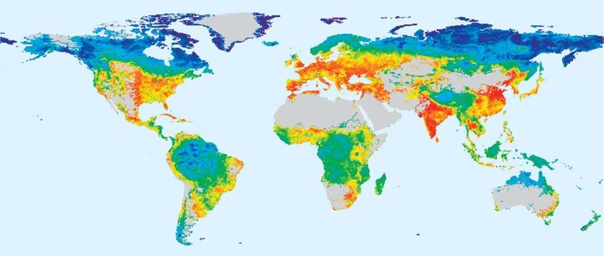

Guidelines on Seasonal Hydrological
Prediction

2021 edition

WMO-No. 1274
EDITORIAL NOTE
   METEOTERM, the WMO terminology database, may be consulted at https://public.wmo.int/en/
   meteoterm.
   Readers who copy hyperlinks by selecting them in the text should be aware that additional
   spaces may appear immediately following http://, https://, ftp://, mailto:, and after slashes (/),
   dashes (-), periods (.) and unbroken sequences of characters (letters and numbers). These spaces
   should be removed from the pasted URL. The correct URL is displayed when hovering over the
   link or when clicking on the link and then copying it from the browser.

WMO-No. 1274

© World Meteorological Organization, 2021

The right of publication in print, electronic and any other form and in any language is reserved by
WMO. Short extracts from WMO publications may be reproduced without authorization, provided
that the complete source is clearly indicated. Editorial correspondence and requests to publish,
reproduce or translate this publication in part or in whole should be addressed to:

Chair, Publications Board
World Meteorological Organization (WMO)
7 bis, avenue de la Paix                                         Tel.: +41 (0) 22 730 84 03
P.O. Box 2300                                                    Fax: +41 (0) 22 730 81 17
CH-1211 Geneva 2, Switzerland                                    Email: publications@wmo.int

ISBN 978-92-63-11274-3
NOTE

The designations employed in WMO publications and the presentation of material in this publication do
not imply the expression of any opinion whatsoever on the part of WMO concerning the legal status of any
country, territory, city or area, or of its authorities, or concerning the delimitation of its frontiers or boundaries.

The mention of specific companies or products does not imply that they are endorsed or recommended by
WMO in preference to others of a similar nature which are not mentioned or advertised.
CONTENTS
                                                                                                                                                                                                                              Page

FOREWORD .  .  .  .  .  .  .  .  .  .  .  .  .  .  .  .  .  .  .  .  .  .  .  .  .  .  .  .  .  .  .  .  .  .  .  .  .  .  .  .  .  .  .  .  .  .  .  .  .  .  .  .  .  .  .  .  .  .  .  .  .  .  .  .  .  .  .  .             v

PREFACE .  .  .  .  .  .  .  .  .  .  .  .  .  .  .  .  .  .  .  .  .  .  .  .  .  .  .  .  .  .  .  .  .  .  .  .  .  .  .  .  .  .  .  .  .  .  .  .  .  .  .  .  .  .  .  .  .  .  .  .  .  .  .  .  .  .  .  .  .  .  .     vi

CHAPTER 1. INTRODUCTION.  .  .  .  .  .  .  .  .  .  .  .  .  .  .  .  .  .  .  .  .  .  .  .  .  .  .  .  .  .  .  .  .  .  .  .  .  .  .  .  .  .  .  .  .  .  .  .  .  .  .  .  .  1
    How to read this document. . . . . . . . . . . . . . . . . . . . . . . . . . . . . . . . . . . . . . . . . . . . . . . . . . . 1

CHAPTER 2. A GENERAL CONCEPT OF SEASONAL HYDROLOGICAL PREDICTION. .  .  .  .  .  .                                                         3
    2.1     Definitions. . . . . . . . . . . . . . . . . . . . . . . . . . . . . . . . . . . . . . . . . . . . . . . . . . . . . . . . . . 3
    2.2     Sources of seasonal predictability . . . . . . . . . . . . . . . . . . . . . . . . . . . . . . . . . . . . . . 4
    2.3     Initial hydrological conditions . . . . . . . . . . . . . . . . . . . . . . . . . . . . . . . . . . . . . . . . . 6
    2.4     Future climate variability. . . . . . . . . . . . . . . . . . . . . . . . . . . . . . . . . . . . . . . . . . . . . . 7
    2.5     Climate conditions during the forecast lead time . . . . . . . . . . . . . . . . . . . . . . . . . 10

CHAPTER 3. KEY CONSIDERATIONS FOR DEVELOPING SEASONAL
.  .  .  .  .  .  .  .  .  .  .  .  .  .  .  .  .  .  .  .  .  .  .  .  .  .  .  .  .  .  .  .  .  .  .  .  .  .  .  .  .  .  .  .  .  .  .  11
    3.1     Understanding of the institutional settings and governance. . . . . . . . . . . . . . . . 11
    3.2     Value of the service. . . . . . . . . . . . . . . . . . . . . . . . . . . . . . . . . . . . . . . . . . . . . . . . . . . 12
    3.3     Identification of user needs. . . . . . . . . . . . . . . . . . . . . . . . . . . . . . . . . . . . . . . . . . . . 13
    3.4     Method selection. . . . . . . . . . . . . . . . . . . . . . . . . . . . . . . . . . . . . . . . . . . . . . . . . . . . 13
    3.5     Development and implementation of forecasting systems . . . . . . . . . . . . . . . . . 13
    3.6     Service development and delivery processes. . . . . . . . . . . . . . . . . . . . . . . . . . . . . 14

CHAPTER 4. USERS AND THEIR NEEDS .  .  .  .  .  .  .  .  .  .  .  .  .  .  .  .  .  .  .  .  .  .  .  .  .  .  .  .  .  .  .  .  .  .  .  .  .  .  .  .  .  .  .  .  .  16
    4.1     User sectors. . . . . . . . . . . . . . . . . . . . . . . . . . . . . . . . . . . . . . . . . . . . . . . . . . . . . . . . . 16
    4.2     User needs. . . . . . . . . . . . . . . . . . . . . . . . . . . . . . . . . . . . . . . . . . . . . . . . . . . . . . . . . . 16

CHAPTER 5. METHODS. .  .  .  .  .  .  .  .  .  .  .  .  .  .  .  .  .  .  .  .  .  .  .  .  .  .  .  .  .  .  .  .  .  .  .  .  .  .  .  .  .  .  .  .  .  .  .  .  .  .  .  .  .  .  .  .  .  .  19
    5.1    Overview. . . . . . . . . . . . . . . . . . . . . . . . . . . . . . . . . . . . . . . . . . . . . . . . . . . . . . . . . . . 19
    5.2    Statistical methods . . . . . . . . . . . . . . . . . . . . . . . . . . . . . . . . . . . . . . . . . . . . . . . . . . 20
            5.2.1      Multi‑variate regression and empirical prediction of streamflow . . . 21
            5.2.2      Advanced statistical method: The Bayesian joint probability
                       approach. . . . . . . . . . . . . . . . . . . . . . . . . . . . . . . . . . . . . . . . . . . . . . . . . . 22
            5.2.3      Predictor selection approaches . . . . . . . . . . . . . . . . . . . . . . . . . . . . . . . 25
    5.3    Dynamical methods. . . . . . . . . . . . . . . . . . . . . . . . . . . . . . . . . . . . . . . . . . . . . . . . . . 26
            5.3.1      Catchment hydrological modelling. . . . . . . . . . . . . . . . . . . . . . . . . . . . 26
            5.3.2      Ensemble Streamflow Prediction based on historical climate
                       or statistical analogues . . . . . . . . . . . . . . . . . . . . . . . . . . . . . . . . . . . . . . 28
            5.3.3      Seasonal climate forecasts and downscaling for hydrological
                       applications . . . . . . . . . . . . . . . . . . . . . . . . . . . . . . . . . . . . . . . . . . . . . . . 30
            5.3.4      Dynamical streamflow forecasting . . . . . . . . . . . . . . . . . . . . . . . . . . . . 35
    5.4    Hybrid approaches merging statistical and dynamical forecasts. . . . . . . . . . . . . 38

CHAPTER 6. DATA FOR SEASONAL HYDROLOGICAL PREDICTION. .  .  .  .  .  .  .  .  .  .  .  .  .  .  .  .  .  .  .  .  40
    6.1     Overview of data demands and availability . . . . . . . . . . . . . . . . . . . . . . . . . . . . . . 40
    6.2     Monitoring networks and spatial resolution. . . . . . . . . . . . . . . . . . . . . . . . . . . . . . 41
    6.3     Length and temporal resolution of data series . . . . . . . . . . . . . . . . . . . . . . . . . . . 41
    6.4     Quality of data: Continuity and homogeneity issues. . . . . . . . . . . . . . . . . . . . . . . 42
    6.5     Data‑sparse regions. . . . . . . . . . . . . . . . . . . . . . . . . . . . . . . . . . . . . . . . . . . . . . . . . . 42
    6.6     Climate forecasts and products . . . . . . . . . . . . . . . . . . . . . . . . . . . . . . . . . . . . . . . . 44
    6.7     Data formatting . . . . . . . . . . . . . . . . . . . . . . . . . . . . . . . . . . . . . . . . . . . . . . . . . . . . . 48

CHAPTER 7. FORECAST VERIFICATION.  .  .  .  .  .  .  .  .  .  .  .  .  .  .  .  .  .  .  .  .  .  .  .  .  .  .  .  .  .  .  .  .  .  .  .  .  .  .  .  .  .  .  .  .  49
    7.1     Reliability . . . . . . . . . . . . . . . . . . . . . . . . . . . . . . . . . . . . . . . . . . . . . . . . . . . . . . . . . . 50
    7.2     Accuracy . . . . . . . . . . . . . . . . . . . . . . . . . . . . . . . . . . . . . . . . . . . . . . . . . . . . . . . . . . . 51
iv                                                      GUIDELINES ON SEASONAL HYDROLOGICAL PREDICTION

                                                                                                                                                                                                                         Page

CHAPTER 8. OPERATIONAL SYSTEM DESIGN CONSIDERATIONS .  .  .  .  .  .  .  .  .  .  .  .  .  .  .  .  .  .  .  .  .  54
    8.1     Key components. . . . . . . . . . . . . . . . . . . . . . . . . . . . . . . . . . . . . . . . . . . . . . . . . . . . . 54
    8.2     Dependencies and constraints. . . . . . . . . . . . . . . . . . . . . . . . . . . . . . . . . . . . . . . . . 54
    8.3     Logical Framework Analysis . . . . . . . . . . . . . . . . . . . . . . . . . . . . . . . . . . . . . . . . . . . 55
    8.4     Case study: WAFARi. . . . . . . . . . . . . . . . . . . . . . . . . . . . . . . . . . . . . . . . . . . . . . . . . . 56

CHAPTER 9. SUMMARY AND WAY FORWARD. .  .  .  .  .  .  .  .  .  .  .  .  .  .  .  .  .  .  .  .  .  .  .  .  .  .  .  .  .  .  .  .  .  .  .  .  .  .                                                                     58

LIST OF ACRONYMS .  .  .  .  .  .  .  .  .  .  .  .  .  .  .  .  .  .  .  .  .  .  .  .  .  .  .  .  .  .  .  .  .  .  .  .  .  .  .  .  .  .  .  .  .  .  .  .  .  .  .  .  .  .  .  .  .  .  .  .  .                   59

REFERENCES.  .  .  .  .  .  .  .  .  .  .  .  .  .  .  .  .  .  .  .  .  .  .  .  .  .  .  .  .  .  .  .  .  .  .  .  .  .  .  .  .  .  .  .  .  .  .  .  .  .  .  .  .  .  .  .  .  .  .  .  .  .  .  .  .  .  .  .     62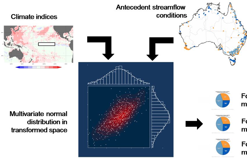
FOREWORD

Seasonal hydrological prediction (SHP) is likely to become a fast‑growing domain of service
delivery activity among WMO Members. It can be seen as a step forward towards a seamless
forecasting system encompassing hydrology and climate aspects related to water resources.
A seasonal forecasting system contributes not only to better management of water resources, but
also to disaster risk reduction, especially for long‑onset phenomena like droughts. So that SHP
does not become a purely academic exercise, it is important that users’ needs and demands are
factored into and addressed in SHP service delivery.

These Guidelines on Seasonal Hydrological Prediction (WMO‑No. 1274) describe a broad practical
and theoretical framework to develop, create, expand or improve SHP within a given social and
institutional framework, with the aim of dramatically increasing economic and environmental
benefits in the country or region where the SHP is applied.

This document is useful for Members in two ways:

–    It provides an overview of SHP practices at the global level to those Members who already
     have some kind of SHP system in place;

–    It can be of help setting up the framework to implement an SHP service for those Members
     who have no system in place.

The present Guidelines were developed in the framework of the former WMO Commission for
Hydrology (CHy), involving experts from the former Open Panel of CHy Experts (OPACHE),
the Chair and Vice‑Chair of the Standing Committee on Hydrological Services (SC‑HYD), and
the Regional Hydrological Advisers of Regional Association (RA) II and RA IV. The final version
was then endorsed by the Commission for Weather, Climate, Water and Related Environmental
Services and Applications (SERCOM).

                                                                            Prof Petteri Taalas
                                                                            Secretary-General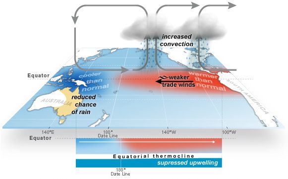
PREFACE

There is an increasing demand from a range of users at the global, regional and sub‑regional
level for seasonal hydrological predictions and services. Showing a remarkable sense of
anticipation, the former WMO Commission for Hydrology (CHy) assembled a group of experts
to prepare the present Guidelines.

Following the WMO Constituent Bodies Reform, and the consequent disbandment of the
CHy, and in view of the growing relevance of the subject, the finalization of these Guidelines
became part of the work plan of the new Commission for Weather, Climate, Water and Related
Environmental Services and Applications (SERCOM).

As President of SERCOM, I am pleased to acknowledge the outstanding contribution of the
three main authors: Dr Jan Danhelka (Czech Hydrometeorological Institute, CHMU, Czechia),
Dr Narendra Tuteja (affiliated with the Bureau of Meteorology, BoM, Australia at the time
of writing, and affiliated with Water New South Wales, Australia at the time of publication)
and Dr Andy Wood (University Corporation for Atmospheric Research, UCAR, United States
of America).

These Guidelines have also benefitted from a thorough peer review process, in line with the
guidance set through the Quality Management Framework for Hydrology (QMF‑H), which
saw the contribution of Dr Julie Kiang (US Geological Survey, USGS, USA), Eng. Leandro David
Kazimierski (National Institute for Water, INA, Argentina) and Dr Vicky Bell (Centre for Ecology
and Hydrology, CEH, United Kingdom of Great Britain and Northern Ireland). Additional
review and feedback was provided by Dr Yuri Simonov and Prof. Marcelo Uriburu Quirno in
their respective capacities as Chair and Vice‑Chair of the Standing Committee on Hydrological
Services (SC‑HYD), and by Dr Sung Kim and Eng. Jose‑Alberto Zuñiga, Regional Hydrological
Advisers of Regions II and IV respectively.

                                                                                    Mr Ian Lisk
                                                                          President of SERCOM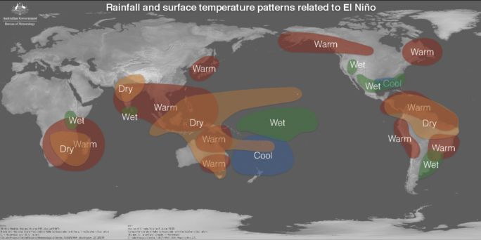
CHAPTER 1. INTRODUCTION

Agriculture accounts for 92% of the global blue water footprint (surface and ground water use)
and the remainder is equally shared between industrial production and domestic water supply
(Mekonnen and Hoekstra, 2011). The exponential rise in demand for water to grow food, supply
industries and sustain urban and rural populations has led to a growing scarcity of fresh water in
many parts of the world. An increasing number of rivers now run dry before reaching the sea for
substantial periods of the year (Postel, 2000). A number of major river basins around the world
supporting large populations experience moderate to severe water scarcity for up to 12 months
of a year, at varying interannual to interdecadal time ranges (Mekonnen and Hoekstra, 2016).
The ecological and economic consequences of increasing degrees of water scarcity—as
evidenced by the Rio Grande, Indus, and Murray‑Darling River basins—can include complete
desiccation during dry seasons, decimation of aquatic biodiversity, and substantial economic
disruption (Hoekstra et al., 2012).

Seasonal climate predictions are now made routinely at a number of operational meteorological
centres around the world, yet predictions for seasonal water availability are not very common
and are largely in the development stage. Extended hydrological predictions of water availability
from supply catchments in the major river basins at multiweek, seasonal and annual time ranges
are critical for supporting operational planning and management, such as water allocation
planning and delivery, environmental water management, minimizing water losses and
balancing supply and demand pressures.

The present Guidelines were prepared further to a request in the WMO Commission for Hydrology
(CHy) ‑ Fourteenth session (WMO‑No. 1105), Part 1: Abridged final report, Annex 1 to Resolution 7,
for a compilation of case studies and guidance on “extended hydrological prediction” for water
resources management, including information on related climate drivers. The Guidelines address
the CHy request by providing information about basic concepts, principles, methods and
drivers relevant for design and development of seasonal hydrological prediction (SHP) systems
and services.

Information presented in these Guidelines is aimed at National Meteorological and Hydrological
Services (NMHSs) or National Hydrological Services (NHSs) responsible for delivering
operational hydrological services in their respective jurisdictions (references in these Guidelines
to “NMHSs” are taken to include both NMHSs and NHSs). A companion Guidance on Operational
Practices for Seasonal Forecasting (WMO‑No. 1246), relating to climate, complements these
Guidelines on seasonal hydrological forecasting. National and regional agencies responsible
for water regulations, water delivery, environmental management and drought contingency
planning and operations, hydropower and inland transport would also benefit from these
Guidelines. An improved understanding of the possible use of seasonal water availability
forecasts within a risk‑based framework can assist with optimal water resources planning and
operations. The Community of Practice on Flood Forecasting would benefit from additional
foresight of catchment wetness and propensity to flooding in areas vulnerable to likely extreme
weather events.

How to read this document

This document is structured into nine chapters and focusses on streamflow forecasting at lead
times beyond the flood time range of 2 to 3 days. This Introduction (Chapter 1) provides context
on SHP services. Definitions and understanding of SHP services across various time ranges
are discussed in Chapter 2, which includes a generic description of sources of predictability
underpinning SHP services provided for long lead times. Key considerations for developing
and delivering SHP services at the national level, and user needs are discussed in Chapter 3 and
Chaptre 4 respectively. Chapter 5 describes methods that can potentially be used for developing
new or upgraded SHP services. Data requirements for large‑scale SHP services are discussed in
Chapter 6. End‑user confidence is important for encouraging users to adopt SHP services for
improved decision‑making. This outcome is contingent upon rigorous forecast verification.
2                       GUIDELINES ON SEASONAL HYDROLOGICAL PREDICTION

The concepts and metrics required to assess forecast performance are discussed in Chapter 7.
Operational systems required for delivering SHP services can potentially be of varying levels
of complexity: concepts related to forecast and modelling systems are discussed in Chapter 8.
Information discussed in these Guidelines is summarized in Chapter 9, which includes a brief
description of challenges and likely future development priorities for SHP services.
CHAPTER 2. A GENERAL CONCEPT OF SEASONAL HYDROLOGICAL PREDICTION

A reliable estimate of the future state of streamflow and other variables of the hydrological cycle
is important information for effective Integrated Water Resources Management (IWRM). Such
information might help meet various user needs, including agricultural demands, hydropower,
water supply and many others. Natural climate variability can dramatically affect water resources,
impacting people and business in virtually all countries. Therefore, improved hydrological
predictions would benefit all.

2.1         Definitions

The WMO Commission for Hydrology (CHy) decided at its fourteenth session that it would be
beneficial to prepare case studies and guidance material on extended hydrological prediction
services. Extended hydrological prediction was naturally understood as an extension to
short‑term and medium‑term forecasts, requiring different methods and approaches, and
which would be a part of longer‑term forecasting developments. Box 1 provides an overview
of the existing WMO definitions of hydrological forecasting ranges, although potential forecast
lead times might often differ significantly depending on the scale of the basin, its time of
concentration and the state of current science. Similarly, the way in which the temporal aspects
of seasonal hydrological forecasting are interpreted by different stakeholders across different
geographical areas may be variable.

For the purpose of this document the term “seasonal hydrological prediction” (SHP) is used
to describe methods and systems for the prediction of future hydrological variables, most
commonly streamflow and its statistical properties. A seasonal forecast period exceeds the
catchment’s time of concentration and the common lead times of quantitative precipitation
forecasts (QPF), typically for a period that covers multiweek to monthly or seasonal time ranges.

Operational hydrological services based upon methods described in this document are
applicable to monthly and seasonal time ranges, which is important for water resource
management planning and operations. The underpinning concepts described in this document
are also broadly applicable to a multiweek time range, albeit with some differences, especially
differences relating to consideration of the meteorological forcing datasets. Therefore, in this
document the terms ”seasonal hydrological prediction”, ”seasonal hydrological forecasts” and
”extended hydrological prediction” are used interchangeably. Figure 1 illustrates mapping
between time ranges of meteorological and hydrological forecasts.

Extended hydrological predictions may change from weeks to several months or a few years,
depending on the persistence of the effect of initial hydrological conditions (that is, the system
memory length) and the effect of other drivers included in the forecasting system. Extended
hydrological predictions are therefore the hydrological equivalent to extended‑range weather
forecasts and monthly, as well as seasonal, outlooks forecasting ranges, following the definitions

                      Box 1. Definitions of forecast ranges in hydrology
      WMO Technical Regulations (WMO-No 49), Volume III: Hydrology, provides definitions of
      the selected forecasting ranges in hydrology as follows:
      Hydrological forecast. An estimation of the magnitude and time of occurrence of
      future hydrological events for a specified period and for a specified locality.
      Short-term hydrological forecast. A hydrological forecast for a period ending up to
      3 days from the time of issue of the forecast.
      Medium-term hydrological forecast. A hydrological forecast for a period ending
      between 3 and 10 days from the time of issue of the forecast.
      Long-term hydrological forecast. A hydrological forecast for a period extending
      beyond 10 days from the time of issue of the forecast.
      Seasonal hydrological forecast. A hydrological forecast for a season (usually covering
      a period of several months or more).
4 GUIDELINES ON SEASONAL HYDROLOGICAL PREDICTION
Meteorological Hydrological
forecast ranges forecast ranges
h - hours, d - days, y - years
Time 2h 12 h 3d 10 d 30 d 2y
Very short Short Medium Extended
Long range Climate
Nowcasts range weather range weather range weather range weather
forecasts forecasts
forecasts forecasts forecasts forecasts
Catchment conditions
Medium-term
Long-term forecasts
Short-term forecasts (up to 3 days) forecasts (beyond 10 days)
(3 to 10 days)
Flood, short-term and medium-term forecasts Extended hydrological predictions
(up to 7 days) (sub-seasonal, seasonal, decadal and interdecadal)
Figure 1. Mapping between hydrological and meteorological forecasting ranges, including
seasonal and extended hydrological predictions. Hydrological forecasts are derived from
meteorological forecasts and/or indicators and initial catchment conditions.
Source: Definitions of meteorological forecasting ranges are adopted from the Manual on the Global Data‑processing and
Forecasting System (WMO‑No. 485), Appendix 1.1. Definitions of hydrological forecasting ranges are adopted from the
Technical Regulations (WMO‑No. 49), Volume III.
of meteorological forecasting ranges in the Manual on the Global Data‑processing and Forecasting
System (WMO‑No. 485). Monthly and seasonal streamflow forecasts are typical examples of the
extended hydrological prediction services.
Recently, a concept of seamless forecasting was adopted by the meteorology community (see
Seamless prediction of the Earth system: From minutes to months (WMO‑No. 1156)). Its aim is to
develop forecasting products that provide users with continuous forecast over various timescales
independently of the forecast preparation methods and procedures. Scientifically correct
methods for merging forecasts for different lead times have also been developed. However,
operational delivery of forecasts using different models remains a challenge (see Seamless
prediction of the Earth system: From minutes to months (WMO‑No. 1156); Pappenberger et al., 2013).
This is largely due to resource constraints of keeping pace with the frequency of rapid upgrades
of different global climate models, each having their own development roadmaps, and different
methods employed to generate retrospective forecasts (or hindcasts) and the resulting impact
on downstream hydrological products and forecast services.
2.2 Sources of seasonal predictability
In general, hydrological predictions over long lead times of weeks, months or seasons are
produced on the basis of two factors (see, for instance, Wood and Lettenmaier, 2008; Yuan et al.,
2015; Figure 2):
1. Information on the initial hydrological conditions (IHCs) of the basin at the onset of a
forecast and which influence future flow, given in terms of recent past streamflow, soil
moisture, actual groundwater storage, snow accumulation, and so forth;
2. Reliable information about future climate variability (FCV), represented by the
development of precipitation, temperature and other atmospheric variables during the
forecast period. These forecasts could be derived from resampled historical data, from
climate models or from observed indices of climate and ocean circulation patterns, such as
sea‑surface temperature.
The impact of these two factors and their respective contribution to predictability, however,
differs significantly across space and time.CHAPTER 2. A GENERAL CONCEPT OF SEASONAL HYDROLOGICAL PREDICTION 5
Extended hydrological prediction
(sub-seasonal to seasonal time scale)
Initial hydrological conditions Future climate variability
Sources of
representing the initial state of the expected during the period
predictability
basin at time of forecast initialization of forecast lead time
Ensemble of historical Modeled
analogues ensemble
Observed hydrological Observed meteorological Historical Climate model
parameters: parameters: meteorological data: forecast:
Sources of
‒ snow cover ‒ precipitation ‒ precipitation ‒ precipitation
information
‒ soil saturation ‒ evapotranspiration ‒ temperature ‒ temperature
‒ streamflow ‒ temperature ‒ sea-surface ‒ other parameters
‒ groundwater temperature
‒ reservoir/lake levels, etc. ‒ large-scale indices
Figure 2. Sources of predictability in a seasonal hydrological prediction system
The obvious drivers of predictability are the physiographic characteristics of the catchment that
affect the run‑off generation process, such as size, geographic location, land cover and land use,
geology and geomorphology, and the presence of seasonal snow — which can be a dominant
water storage variable — or groundwater interactions. It is important to distinguish between
static or quasi‑static characteristics (such as size, geographic location, geology, geomorphology),
low dynamic characteristics (land cover and land use) and dynamic characteristics (seasonal
snow and groundwater interactions) as this impacts on operational aspects such as the provision
of data. For example, data collection may be a one‑off task (as is the case for static or quasi‑static
characteristics) or a continuous requirement (as is the case for seasonal snow and groundwater
interactions, or, at a higher frequency, land cover and land use). Large basins are likely to retain
longer memory of IHCs than fast‑responding basins; similarly, different predictability between
deep soil and shallow soil cover with small retention capacity is to be expected. The longest
seasonal predictability is found in basins exhibiting either large seasonal snowpacks, or strong
groundwater influences. The present Guidelines will not address the above factors in detail,
however particular attention will be paid to the role of IHCs and FCV information.
Several studies have aimed to quantify variations in predictability contributions from potential
IHCs and FCV at monthly to seasonal scales at both the global level (for example, Shukla et al.,
2013) and regional level (for example, Singla et al., 2012; Wood et al., 2005). The results of
these studies demonstrated that the impact of IHCs was up to six months in snow and arid
climate zones (according to the Köppen climate classification), but less than one month in
warm temperature zones for some periods of the year (Shukla et al., 2013). It is relatively easy to
estimate the memory length of a basin, by running a simulation model with the same forcing
conditions starting from different IHCs, and comparing the outputs to identify the time at which
the time series start to converge. That process can be repeated for different initiation times along
the year (or along the relevant months).
Performing this simulation exercise for specific catchments before starting an SHP operation
is recommended. More recently, new metrics such as “forecast skill elasticities” have been
introduced that quantify the sensitivity of the skill of seasonal streamflow forecasts to either IHCs
or FCV or both (Wood et al., 2016b; Arnal et al., 2017).
The following sections discuss IHCs and FCV sources of predictability in greater detail.6 GUIDELINES ON SEASONAL HYDROLOGICAL PREDICTION 2.3 Initial hydrological conditions The predictability attributable to IHCs may vary according to location and time of the year. Generally, pronounced seasonality of the annual precipitation cycle and its state (liquid or solid) is an indicator of a potentially high impact of IHCs on the predictability of a particular hydrological system. Research has demonstrated that information about snow accumulation contributes considerably to the predictability of streamflow up to several months ahead. As a result, the ability to replenish reservoir storage can, for instance, be predicted with reasonably high accuracy (see, for instance, Koster et al., 2010). Enhanced predictability attributable to the influence of strong seasonality of rainfall on IHCs has also been demonstrated for a wide range of basins and different climatic settings. Overall, the streamflow predictability derived from IHCs is not persistent throughout the annual cycle. A stronger influence is usually observed during the transition from the wet to dry season than in the opposite direction (Yuan et al., 2015; Shukla et al., 2013). Soil moisture and recent streamflow both change more dynamically than snowpack, and thus cause a shorter memory on the hydrological response than snowpack. However, soil moisture and recent streamflow can be used in large areas of the world outside the snow regime dominated basins (Mahanama et al., 2012). The influence of groundwater bodies on long‑term hydrological behaviour is not well researched for many regions. However, groundwater storage can be expected to retain a longer memory than soil moisture (Paiva et al., 2012) due to its slower dynamical response. Groundwater storage becomes particularly important during the low‑flow periods in places with strong seasonality in rainfall and groundwater recharge. A specific behaviour might be found in large river systems such as the Amazon, the White Nile or the Niger River (Paiva et al., 2012). In such cases, due to extended residence times of the flood in the main channel network and inundation of interior wetland areas, the seasonal forecast uses information about observed streamflow and inundation volume (extent) as an IHC to considerably enhance the predictability of flow much further downstream. Similarly, in managed systems characterized by significant impacts of man‑made reservoirs and related operations, as well as large river basin systems where natural lakes are present, initial storage volumes in the reservoirs should be considered as an important IHC for seasonal streamflow prediction. The extent to which IHCs contribute to the overall skill of seasonal streamflow prediction is not only site‑ and time‑specific but also depends on the prediction method used and climatic conditions (as well as the length of the lead time in relation to the memory length). On the one hand, the impact of IHCs will be significant in situations where the river systems are large and perennial, and the spread of future climate drivers (especially precipitation) is relatively small. Such is the case when switching from wet to dry seasons as mentioned above (Yuan et al., 2013b). In such cases, dynamical modelling, which couples climate and hydrological models, provides relatively narrow ensembles when compared to classical Ensemble Streamflow Prediction (ESP) methods (Anderson, 1972; Wood et al., 2016a; Li et al., 2009), which use a historical climatology as meteorological ensemble input (see Chapter 5). On the other hand, the importance of IHCs might decrease in situations where a strong climate driver dominates the predictability. For example, the impact of IHCs might be expected to be smaller during the significant El Niño and La Niña years than during neutral years (Yuan et al., 2013a; Sinha and Sankarasubramanian, 2013; Wood et al., 2005) for a location where hydrological variables are highly correlated with El Niño‑Southern Oscillation (ENSO). Areas that exhibit marked seasonal behaviour but where catchments are associated with highly unpredictable and non‑linear response to rainfall events may also fall into this category. In the case of hydrological extremes, an SHP that is based on IHCs information will likely provide valuable information after the onset of extreme wet events, especially in large river basins
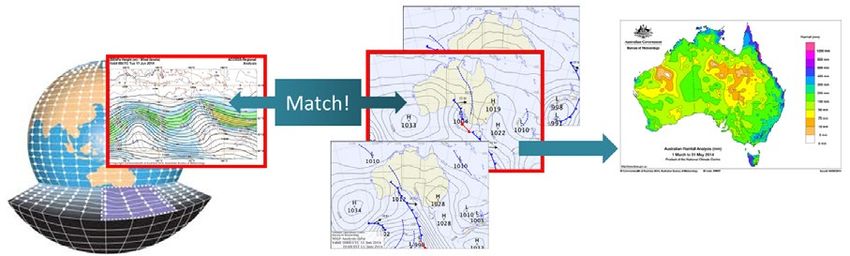
CHAPTER 2. A GENERAL CONCEPT OF SEASONAL HYDROLOGICAL PREDICTION                     7

exhibiting persistence and seasonality. However, it cannot predict the onset itself, nor a tipping
point, such as a peak and start of the recovery (Pan et al., 2013), as this change is exclusively
caused by future weather developments.

To benefit from the potential of IHCs, it is critical to have the ability to adequately monitor the
respective IHCs and their spatial and temporal variability. Monitoring is generally achieved
through a variety of strategies in combination, including direct and indirect measurement
(through in situ and remotely sensed observations), as well as watershed or land surface
modelling. There is a demand for quality observational networks of in situ stations (precipitation
and streamflow in particular), for exploitation of remotely sensed data and for methods for
interpolation and modelling. For example, in the case of snow water equivalence (SWE), a
sufficient number of in situ observations of SWE might be complemented by satellite information
about snow cover extent and both may be exploited using physical models or geographical
information system (GIS) techniques to derive the overall estimates of water stored in the
basin in the form of snow. The exact description of IHCs in space and time and their use in
the hydrological forecasting system along with advanced data assimilation methods have the
potential to further enhance the prediction skill, especially in cases of complex SHP systems
(Yuan et al., 2015).

However, when evaluating the information content in IHCs, one must consider natural and
artificial factors that might affect their applicability, such as changes in land use and land cover.
Significant changes which have occurred in the past might mimic the real value of IHCs on one
hand, while future changes or high interannual variability (such as crop rotation) might change a
water balance and thus decrease the relative contribution of IHCs towards a skilful SHP system.

2.4          Future climate variability

Large‑scale climate patterns have been found to be important sources of seasonal predictability
in various parts of the world. Their impact, in some cases, reaches even relatively distant areas.
For instance, ENSO has been detected to have distant impact, such as on the monsoon season
over the Indian subcontinent and on Africa (Figure 3). Impact of climatic phenomena over such
long distances is also referred to as teleconnection.

The most prominent example of a large‑scale climate indicator is ENSO (see El Niño/Southern
Oscillation (WMO‑No. 1145)). ENSO describes the natural variations in the ocean (sea‑surface
temperature) and atmosphere (sea‑level pressure and wind patterns) in the tropical Pacific. An
El Niño phase develops when warmer‑than‑usual sea‑surface temperature occurs in central and
eastern equatorial Pacific. Such conditions reduce a normal sea‑level pressure gradient between
the west and east tropical Pacific that drives trade winds. With weaker trade winds, warm water
tends to accumulate in eastern Pacific, interrupting cold water upwell in this region. The opposite
phase of cooler waters in given areas is called La Niña. A clear signal from ENSO can be found in
the temperature, precipitation and flood regime in Australia, North and South America, Asia or
Africa in various seasons (see El Niño/Southern Oscillation (WMO‑No. 1145); Ward et al., 2014).

Known large‑scale patterns are often described by means of pre‑defined indices as indicators
designed to quantify the pattern state and thus to provide the input for possible regression
analysis to study their impact on the climate at given locations. ENSO is described by several
indices (Niño 1+2, Niño 3, Niño 4, Niño 3.4, ENSO Modoki Index, Multi‑variate ENSO
Index (MEI)) which are mostly based on observed oceanic and atmospheric departures from
long‑term average values of a variable, the so‑called anomaly at a specific location or a difference
in sea‑surface temperature between selected areas. Lerat et al. (2015) have demonstrated that
water availability in major reservoirs in south‑eastern Australia can be reduced by up to 30%
during a strong ENSO event relative to that in an average year.

While the typical impact of ENSO is recognized and understood, there are many other large‑scale
patterns with less pronounced impact. Nevertheless, their contribution to predictability of
precipitation and temperature characteristics might have a longer duration throughout the
forecasting interval and might be lagged for several months. For example, research has indicated
that the April value of the East Atlantic‑Western Russia pattern is well‑correlated with July
8                            GUIDELINES ON SEASONAL HYDROLOGICAL PREDICTION

     (a)

                                                                          © Commonwealth of Australia 2013

     (b)

             Figure 3. (a) Schematic diagram of the El Niño‑Southern Oscillation (ENSO);
           (b) The likely impacts of the El Niño phase on rainfall and temperature patterns
Source: Australian Bureau of Meteorology

precipitation in small basins in Central Europe (Šípek, 2013). Similarly, the March‑April‑May
sea‑surface temperature of the Indian and Pacific oceans has been found to provide useful
prediction of summer (June to August) streamflow of the Yangtze River in China (Xu et al., 2007).

An important issue for the future application of large‑scale pattern analysis for operational
seasonal forecasting is the need for additional research on the interaction of various large‑scale
patterns. While some large‑scale patterns are interrelated (such as the Pacific and North
American index, as well as ENSO), or in general describe a similar state of the atmosphere over
the same region, there might also be contradictory effects among patterns. For example, the
Indian Ocean Dipole (IOD) has been found to affect the drought in south‑eastern Australia
more strongly than El Niño (Ummenhofer et al., 2009). The combined effect of various patterns
is further influenced by their different periodicity. For example, while ENSO affects interannual
variability (typically 3–8‑year frequency of occurrence of positive and negative phases), Pacific
Decadal Oscillation (PDO) and North Atlantic Oscillation (NAO) have decadal and longer cycles,
while the Madden‑Julian Oscillation (MJO) typically occurs in 30 to 60 day intervals.

Similarly, the intensity of a pattern expressed by the values of the indices does not necessarily
imply that there will be a strong actual impact on streamflow and vice versa.

Table 1 introduces a short overview of selected large‑scale patterns and their indices.
CHAPTER 2. A GENERAL CONCEPT OF SEASONAL HYDROLOGICAL PREDICTION
Table 1. Overview of selected large‑scale patterns that are known to influence climate
Large‑scale pattern Acronym Region Nature Indices Regions impacted
El Niño‑Southern ENSO Equatorial Pacific Sea‑surface temperature Niño 1+2 South America, North America, Australia,
Oscillation anomaly and atmospheric Niño 3.4 Pacific, South Asia, South‑East Asia, East Asia,
pressure anomaly South‑East Africa, East Africa, West Africa,
Niño 4 Caribbean
EMI (ENSO Modoki)
Multi‑variate ENSO
SOI
Madden‑Julian MJO Pacific, Indian Ocean, Atmospheric circulation MJO Tropics, Africa, North America, South America
Oscillation Africa, South America and convection
Pacific Decadal PDO Pacific Sea‑surface temperature PDO Pacific, North America, South America
Oscillation anomaly
North Atlantic NAO North Atlantic Atmospheric pressure NAO North America, Europe and Mediterranean,
Oscillation anomaly North Atlantic
Atlantic Multi‑decadal AMO North Atlantic Sea‑surface temperature AMO North America, Europe and Mediterranean,
Oscillation anomaly North Atlantic, South America
Indian Ocean Dipole IOD Indian Ocean Sea‑surface temperature IOD Australia, East Africa, Arabian Peninsula, South
anomaly and South‑East Asia, South America
North Pacific Oscillation NPO North Pacific Atmospheric pressure NPI North America
anomaly
Southern Annular Mode SAM/AAO Southern Ocean SAM Southern Australia
Scandinavian Pattern Europe Atmospheric pressure Europe, North Atlantic, Siberia
anomaly
East Atlantic‑Western EA‑WR North Atlantic, Europe Atmospheric pressure Europe, North Atlantic, Siberia, East North
Russia Oscillation anomaly America, North Africa
Arctic Oscillation AO Arctic Atmospheric pressure AO North America, Europe and Mediterranean,
anomaly Siberia and East Asia, North trade winds
Mediterranean MOI Mediterranean Atmospheric pressure MOI Mediterranean
Oscillation Index anomaly
Antarctic Oscillation AAO Antarctic Atmospheric pressure AAO South America, Australia, Antarctica
anomaly
Pacific‑North American PNA North Pacific North Atmospheric pressure PNA North America
Index America, anomaly
Intraseasonal Variability IS South tropical South Outgoing longwave SIS South‑eastern South America
America radiation anomaly10 GUIDELINES ON SEASONAL HYDROLOGICAL PREDICTION Although a strong correlation has been found between some parameters on very distant areas, the physical mechanism underlying certain teleconnections remains hidden. In these cases, special vigilance is required. In addition, knowledge of a physical mechanism of teleconnection might be a valuable factor in communicating the methodology of analysis and derived prediction system to the users and building their trust in the forecast. 2.5 Climate conditions during the forecast lead time For most hydrological systems, the production of an SHP through modelling requires the IHCs as the model initial condition, and information about future weather and climate drivers as the boundary condition (the forcing). The latter information might come from the climate forecasts or from historical analogues. Estimates of future development of weather and climate variables are implicitly more uncertain than the observations and estimates of IHCs. In addition, this uncertainty typically increases with increasing lead time of the forecast. This uncertainty cannot be neglected: for lead times typical for SHP work the ensemble‑based probabilistic approach is therefore used almost exclusively (see Chapter 5). It has been demonstrated that even current state of the art climate modelling does not reproduce the effects of teleconnections with a satisfactory skill level, with the exception of ENSO (Tippett et al., 2012). Therefore, improvement in global climate model forecasts is necessary in order to improve water availability predictions for hydrological applications for long lead times. A second potential area of improvement for hydrological predictability and accuracy of SHP lies in the post‑processing of climate model forecasts by considering the effects of large‑scale circulation patterns and removing biases in predicted rainfall occurrence and amounts (see Chapter 5).
CHAPTER 3. KEY CONSIDERATIONS FOR DEVELOPING SEASONAL HYDROLOGICAL
PREDICTION

Although the institutional arrangements of National Hydrological Services or National
Meteorological and Hydrological Services (collectively referred to here as NMHSs) within a
national governmental structure differ significantly among countries, most countries have an
organization directly or indirectly mandated by law to deliver hydrological services at the local or
national level (see Guidelines on the role, operation and management of National Hydrological Services
(WMO‑No. 1003)). Hydrological forecasting is one of the basic responsibilities of many NMHSs.
WMO promotes a single authoritative voice for issuing forecasts and warnings. At the same time,
a concept of seamless forecasting is generally accepted as the future target in forecasting product
development. Therefore, NMHSs must naturally be considered as organizations responsible for
providing SHP services.

Development of an SHP system is often a response to a specific impetus, which in most cases is
a prolonged episode of drought. When dealing with the task of developing an SHP system, the
following six key areas for consideration have been identified:

–     Understanding of the institutional settings and governance;

–     Value of the service to different sectors of the national economy;

–     Identification of user needs;

–     Method selection and the forecasting approach;

–     Development and implementation of the forecasting system including plans for
      transitioning research to operations;

–     Service development and delivery processes including products, communication, feedback
      and forecast dissemination strategies, training and education.

These areas are obviously interlinked and often overlap to a certain degree. Each will now be
considered in turn.

3.1          Understanding of the institutional settings and governance

An initial key step is the process of identifying a relevant institutional framework covering
climate and hydrological service providers (Figure 4). Important considerations include:
governance and collaborative arrangements between agencies responsible for developing water
policies; regulations and delivery of water and environmental management; individual users
(farmers, businesses, and so forth); available data (historical observation); tools (models); and
infrastructure (Internet connection, communication channels to users). These factors determine

                 Government institutions responsible for setting national/jurisdictional
                                     policies and providing funds

                 National Meteorological and
                                                           Research and development
                     Hydrological Service
                                                           agencies (research services)
                    (operational services)

               End users - water, agriculture, environment, energy, tourism, navigation,
                                    finance, health and other sectors

      Figure 4. Overview of the institutional framework and key stakeholders involved in
              development of national seasonal hydrological prediction services
12 GUIDELINES ON SEASONAL HYDROLOGICAL PREDICTION
the NMHS’s options for developing the SHP system and its potential cost. User needs identified
through workshops and discussions with a wide range of stakeholders need to be assessed
against what is possible and based upon the current state of scientific knowledge and technical
capabilities.
The development and delivery pathway of SHP by NMHSs will depend on the institutional
framework, modelling infrastructure and data availability. In particular, data availability and
quality might be a critical issue in many regions of the world. However, the lack of data does
not necessarily mean that SHPs cannot be developed, as existing global climate datasets might
provide sufficient information for some methods of SHP. Data might also be derived from written
materials or reconstructed based on indirect methods (see Chapter 6).
Capacities of the NMHS also need to be objectively assessed. This includes data,
hydrometeorological and hydrological capabilities, as well as technical infrastructure (such as
computing capacities). Such an assessment needs to be done from the perspective of capacities
required for system development (which is a somewhat complex field requiring advanced
scientific knowledge and capacities for hindcasting), and from the perspective of sustainable
day‑to‑day system operations (requiring trained staff, technical capacities and real‑time data
processing).
3.2 Value of the service
An NMHS is a business, and should be run in a business‑like manner (see Guidelines on the role,
operation and management of National Hydrological Services (WMO‑No. 1003)). That does not
imply that a service such as SHP needs to be a “paid service”, but rather that the customer’s or
user’s needs must be a priority in design of the service and products. Furthermore, a cost‑benefit
analysis should be used in service (system) development and should provide insights to assist
decision‑making on future investment and enhancements/upgrades (see Valuing Weather and
Climate: Economic Assessment of Meteorological and Hydrological Services (WMO‑No. 1153)).
Development of a robust operational SHP modelling and forecast system is essential for delivery
of services on a national scale (see Chapter 8). Such an SHP forecast system might be viewed
from the following perspectives:
– From a scientific point of view. The aim is to develop the best product (forecasting system)
simply measured by the demonstrated forecasting skill based on a hindcasting experiment.
– From an operational point of view. The aim should be to deliver the best service. In this
case, the service has to be assessed in terms of: (a) investment cost‑benefit effectiveness;
(b) cost of operation; (c) sustainability of service (human capacities, infrastructure, data,
financial resources); and (d) forecasting skill.
Many research teams are using ensemble dynamical modelling methods based on climate model
forecasts which may be more complex than a simple, cheaper and more or less equally skilful
method for initial implementation and operations. Due to widespread availability of global
climate forecasts from many centres around the world, many countries are aiming to develop
SHP services based upon dynamical methods while making use of the hydrological modelling
infrastructure already available nationally for water management purposes.
Generally, a multiphase process or step‑by‑step development of the system from simple to
complex has the potential to generate improved cost‑benefit ratios over the long term. It enables
quick development of a functional SHP system prototype, in order to demonstrate its value to
the users and to establish the frameworks with cooperating institutions and users. Step‑by‑step
development also allows for a sustainable model of operation to be set up, and for decisions
on investments to be made at each further step, respecting a value‑for‑money principle while
aiming to respond best to users’ demands and preferences. As an example, in Australia, both
seasonal climate and streamflow outlooks were initially delivered to the public using statisticalCHAPTER 3. KEY CONSIDERATIONS FOR DEVELOPING SEASONAL HYDROLOGICAL PREDICTION 13 methods. In recent years, the seasonal climate outlook has moved to the use of dynamical methods alone while the seasonal streamflow forecast service is being transitioned to the use of dynamical forecasting approaches in addition to the current statistical approach (see Chapter 5). Various methods of cost and benefit analysis that can be applied in evaluating hydrometeorological services and products are described in Valuing Weather and Climate: Economic Assessment of Meteorological and Hydrological Services (WMO‑No. 1153). In general, two types of methods exist: (a) a sector‑specific method to estimate the costs and economic benefits in users’ sectors using economic data and expert surveys; and (b) a benchmarking method to assess costs and benefits observed in other countries (Valuing Weather and Climate: Economic Assessment of Meteorological and Hydrological Services (WMO‑No. 1153)). It is also important to identify the cost holders and beneficiaries which will in many cases be different institutions and individuals. 3.3 Identification of user needs Identification of users, their needs, and their skills (see Chapter 4) is a key element in system design, development and operation. Emphasis should be placed on what the client requires, not what the supplier wants to supply. It is therefore the job of the latter to determine: what the client requires and ways of providing it (see Guidelines on the role, operation and management of National Hydrological Services (WMO‑No. 1003)). This includes identification of the product (form, customization, etc.); the means of service delivery (such as availability of information via the Internet and web services); possibilities of pricing, or funding mechanisms (which ensure sustainability of the service and meet the client’s expectations of value for money); and demonstration of the end‑user benefits. It is critical to involve users from the start of the service design and development to properly address their needs and preferences, and to keep them involved throughout the process. NMHSs “also should recognize that client needs and expectations are changing continually, as the decisions that clients make become more complex and risky” (see Guidelines on the role, operation and management of National Hydrological Services (WMO‑No. 1003)). The worst scenario is to build and operate a system without dissemination of outputs to users, which means expending all the financial resources without realizing any benefits. 3.4 Method selection A selection of the method to be used in SHP (see Chapter 5) is conditioned on the above‑mentioned factors including the availability of historical and operational data, a review of the potential skill of particular methods in the area of interest, user needs and the available capacity and resources. When balancing all those factors, the SHP method could serve as a benchmark for comparison of skill, cost and benefits of other methods. 3.5 Development and implementation of forecasting systems Technical development of the SHP system might be done in‑house by the NMHS or by external experts (at universities, research centres) if this task exceeds the capabilities or capacities of NMHS staff. In both cases, a proper project management framework must be established. In most cases, weather, climate, hydrology and information technology domains need to work closely with the research and development sector for developing the required forecast systems. WMO Guidelines on the role, operation and management of National Hydrological Services (WMO‑No. 1003) proposes that “A logframe analysis should, properly, be carried out at the earliest stage of project development, to ensure that the project concept is logically structured and actually will achieve the outcomes sought”.
14                         GUIDELINES ON SEASONAL HYDROLOGICAL PREDICTION

In addition to the elements named in Box 2, the Logical Framework Analysis needs to consider
how the forecasts will be communicated to end users and what could be the barriers to adoption
of forecasts. Therefore, a communication and adoption strategy is generally needed.

                         Box 2: Summary of a Logical Framework Analysis
 –    What is the goal of the project? Development of an SHP system
 –    What activities need to be carried out to achieve that goal? Major steps of development (see below,
      steps (a) to (j))
 –    What resources and inputs are required? Data, tools, budget, human expertise
 –    What could affect the success of the project? User support, capacities
 –    How will the progress and success be measured and verified? Setting milestones, deliverables
      and indicators

The major steps of development are:

(a)   Clear identification of end‑user needs;

(b) Assessment of the scientific capabilities, and knowledge and technology gaps;

(c)   Evaluation of options and development of the roadmap for SHP services;

(d) Design of the SHP system based on identification of conditions and users’ needs;

(e)   Acquisition of the required data, establishing data access and quality assurance and quality
      control protocols, and processing of historical data;

(f)   Development of the hydrological forecasting system for delivering SHP services;

(g) Use of hindcast experiments to verify the system design and setting and demonstrating its
    value for the users;

(h)   Transition of SHP research to operations, including necessary human and technological
      capacity‑building;

(i)   Product design, and development of a suitable forecasting system including end‑to‑end
      delivery of forecast updates for the needs of specific users;

(j)   Elaboration of a communication and adoption strategy, including an assessment of the
      barriers to adoption of forecasts by end users.

An implementation plan for real‑time operations is also required, which involves the following:

–     Installation of SHP software packages on new or existing hardware or IT infrastructure;

–     Establishment of operational data flows and products distribution;

–     Organization of service operation (such as standard operational procedures,
      responsibilities, training of forecasters);

–     Establishment of user outreach and feedback mechanisms.

3.6           Service development and delivery processes

“It is becoming increasingly important for Hydrological Service staff to learn to package their
products to meet the needs of particular clients and thus add value.” (see Guidelines on the role,
operation and management of National Hydrological Services (WMO‑No. 1003)).
CHAPTER 3. KEY CONSIDERATIONS FOR DEVELOPING SEASONAL HYDROLOGICAL PREDICTION 15 A good product should be understandable, it should provide the relevant information to the user, and it should minimize the risk of misinterpretation. A general trend in forecasting is to move from phenomenon‑based to impact‑based forecast products that better reflect the users’ needs. In addition, experience has shown that advice or guidance on actions to be taken, which are attached to the forecast, are valuable for the general public as well as specific user communities (for example, the seasonal forecast produced by the Regional Climate Outlook Forum (RCOF) covering West Africa includes advice on crop selection for farmers). Producer‑user communication is a continuous process of promotion and user education on the one hand, and feedback to the producer on products and their usability, on the other hand. As expressed previously, the main obstacle in implementing a functional SHP system might be its adoption by users for everyday use and decisions. In a market economy, the consumer naturally selects products that provide the best value for money. Similarly, in the case of provision of services like SHP, regardless of whether the service is provided as a public good or commercial product, users must understand its value. To do so, they must recognize how such information should be influencing their decision‑making processes. Therefore, a critical issue of service implementation is verification of forecasts and demonstration of forecast skill and value to the users, not only at the time of implementation of the SHP system but continuously during its operation, to build and retain user trust and confidence in the service.
CHAPTER 4. USERS AND THEIR NEEDS

4.1                User sectors

The World Economic Forum’s Global Risks Report recognized the water crisis as the top global
risk in terms of its adverse impacts on various countries around the world for the next 10 years
(World Economic Forum, 2016). Future projections about water availability, as a result of climate
change, projected exponential population increases and rapid industrialization of developing
economies during the twenty‑first century all indicate a direct threat to water security for many
countries around the globe (see Figure 5).

Water availability is a general prerequisite for life and economic activities; therefore, the range
of potential users of seasonal hydrological forecasts covers the majority of the main economic
sectors either directly or indirectly (see Table 2). A good understanding of the national water
security situation, institutional settings and governance arrangements, and needs for water
availability across various sectors of the economy, is essential prior to developing a roadmap of
national SHP services.

4.2                User needs

The identification of users’ needs must be an initial step in seasonal forecasting system
development, and it warrants significant attention to prevent future misunderstandings or
solutions that may undermine the use of seasonal forecasts in users’ decision‑making. While
engaging users, it is advisable to introduce the benefits of seasonal forecast, using available
examples from around the world, or expected products and their potential use. Communication
with users must be accommodated at initial planning stages to maximize benefits from SHP
services at a later stage. This approach will also assist in minimizing barriers to adoption of
forecasts by end users.

      Incident human water
          security threat
           0.2         0.6         1
      0          0.4         0.8                                            No appreciable flow

          Figure 5. Risks to water security are a threat to national economies across the world.
              “Incident human water security threat” (from 0‑1) is a relative threat index.
Source: Vörösmarty et al., 2010
You can also read