Hartley Anderson Limited - Marine Environmental Science and Consultancy Screening for Appropriate Assessment Ballycotton Harbour Dredging ...
←
→
Page content transcription
If your browser does not render page correctly, please read the page content below
Hartley Anderson Limited
Marine Environmental Science and Consultancy

Screening for Appropriate Assessment

Ballycotton Harbour          Dredging      Foreshore
Licence Application

                                      Report to
       Department of Housing, Local Government
                                   and Heritage

                                          March 2022
Hartley Anderson Limited
 Screening for Appropriate Assessment                                                                  March 2022
                                                                                                           Page 1

TABLE OF CONTENTS

SECTION 1 - INTRODUCTION .................................................................................. 2
  1.1      Background ................................................................................................... 2
  1.2      Application documents submitted.................................................................. 2
  1.3      Relevant consultation responses .................................................................. 2
  1.4      Legislative context....................................................................................... 12
SECTION 2 - DESCRIPTION OF PROPOSED WORKS ......................................... 13
  2.1      Proposed works .......................................................................................... 13
  2.2      Sediment analyses ...................................................................................... 13
  2.3      Dredging methodology ................................................................................ 16
  2.4      Expected schedule ...................................................................................... 17
  2.5      Review of proposed works .......................................................................... 17
SECTION 3 - STAGE 1 SCREENING FOR APPROPRIATE ASSESSMENT ......... 19
  3.1      Basis for screening the project .................................................................... 19
  3.2      Identification of possible effects .................................................................. 19
  3.3      Identification of relevant sites and features ................................................. 22
  3.4      Sites identified by the applicant to be screened for AA ............................... 25
  3.5      In-combination effects ................................................................................. 33
  3.6      Transboundary effects ................................................................................ 33
  3.7      Screening conclusion .................................................................................. 33
BIBLIOGRAPHY ...................................................................................................... 36
Hartley Anderson Limited
    Screening for Appropriate Assessment                                            March 2022
                                                                                         Page 2

SECTION 1 - INTRODUCTION
1.1       Background
Arup with Hartley Anderson Limited have been commissioned by the Department of Housing,
Local Government and Heritage (DHLGH) to conduct a Screening for Appropriate Assessment
(AA) (stage 1 screening for the likelihood of significant effects on Natura 2000 sites), from an
application by Cork County Council (CCC) for a Foreshore Licence to cover the proposed
dredging of Ballycotton Harbour to restore it to navigable depths, and the dumping at sea of
uncontaminated dredged material at the previously used dumping site to the south of Power
Head, 16km southwest of Ballycotton. Any contaminated dredged material will be disposed
of at a licensed landfill facility.

1.2       Application documents submitted
A number of application documents submitted by CCC have informed this AA Screening,
including:

      •   Application form [Applicant: Cork County Council: 30 April 2021]
      •   Admiralty Chart [Byrne Looby Partners, dated 23/03/2021]
      •   Foreshore License Map 1 [Byrne Looby Partners, dated 22/03/2021]
      •   Foreshore License Map 2 [Byrne Looby Partners, dated 22/03/2021]
      •   Cross Section [Byrne Looby Partners, dated 22/03/2021]
      •   Existing Bathymetry [Byrne Looby Partners, dated 22/03/2021]
      •   Overall Site Layout Plan [Byrne Looby Partners, dated 22/03/2021]
      •   Proposed Dredging Arrangement [Byrne Looby Partners, dated 22/03/2021]
      •   Natura Impact Statement [MERC Consultants, dated 13/05/2021 and an updated
          version of 21/01/2022]
      •   Marine Mammal Risk Assessment [IWDG Consulting, undated]
      •   Bird Survey Report [EirEco, dated 25/07/2019]
      •   Foreshore Application Report [Byrne Looby Partners, dated 22/03/2021]
      •   Prescribed Body Consultation
              o Prescribed Bodies Observations
              o Applicant's response to Prescribed Bodies Observations.

An application (S0032-011) for a Dumping at Sea Licence (required under the Dumping at Sea
Act 1996 as amended) for the proposed works is currently with the EPA for consideration.

1.3       Relevant consultation responses
The licence application was open for public consultation between 26th July 2021 to 24th August
2021.

Consultation responses from the prescribed bodies are provided in Table 1.1. Note that most
of the responses are not directed at the Habitats Directive aspects of the proposal.

1   https://epawebapp.epa.ie/terminalfour/DaS/DaS-view.jsp?regno=S0032-01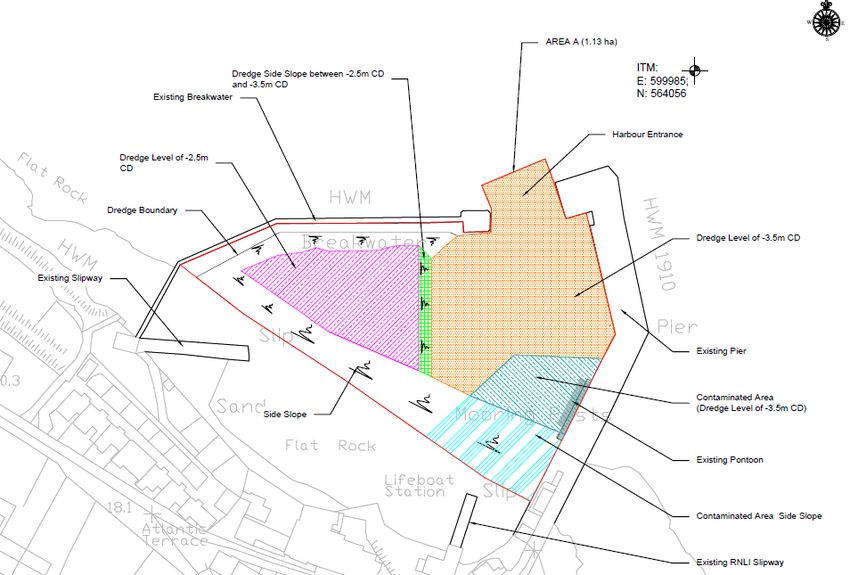
Hartley Anderson Limited
Screening for Appropriate Assessment                                                                                                              March 2022
                                                                                                                                                      Page 3

Table 1.1: Responses from prescribed bodies to the consultation
                               Statutory Body                                                              Applicant’s Response
 Marine Advisor of the Department of Housing local Government and                  The Applicant had no objection to the conditions proposed by the Marine
 Heritage                                                                          Advisor.

 The Marine Advisor noted the findings of his/her inspection of the site took
 place on 19/10/2021 and that Irish Water have application FS007022 under
 consideration for a licence to construct a temporary work area which
 overlaps partially with the proposed dredge area. The Marine Advisor
 considered that basic sequencing and communications should ensure the
 works do not conflict. The existing moorings in the harbour are to be lifted
 and replaced by the mooring holders after the dredging is complete. Leisure
 users and fishers will have to accept the disruption caused by the dredging
 by either removing the vessel for the period of dredging or tying up to the
 pier when weather allows and seeking shelter in Cork Harbour when poor
 weather is forecast. However, accommodation will have to be made for the
 lifeboat, as in certain poor weather it cannot remain alongside the pier and it
 cannot be relocated to Cork Harbour and remain on service. A mooring
 within the harbour will have to be provided at all times throughout the works
 to the RNLI’s specification and requirements to ensure the lifeboat’s
 lifesaving service is maintained at all times.

 The Marine Advisor noted there are no known or established claims of
 private ownership of the foreshore at Ballycotton Harbour or off Power
 Head. Therefore, the foreshore the subject of the application is currently
 presumed state owned and proposed development does not conflict with the
 existing overlapping licences, nor does it significantly injure the public use
 of, access to and enjoyment of the foreshore. Total area of foreshore the
 subject of the application: Dredge area: 1.13 ha, Dump site: 377.8ha.

 The proposed works are to ensure the safe operation of the harbour and
 safe navigation and mooring of vessels within the harbour. Harbours such
 as Ballycotton are the gateway to the sea and are fundamental
 infrastructure that supports public access, marine leisure, tourism, sea
 fishing, communications and the associated local community and economy.
Hartley Anderson Limited
Screening for Appropriate Assessment March 2022
Page 4
Statutory Body Applicant’s Response
Considering this, the Marine Advisor was satisfied that the proposed
dredging and disposal at sea are in the public interest.
The Marine Advisor noted that there are no conflicts with existing leases or
licences and the works as proposed are in the public interest. The works, if
completed as proposed and in accordance with conditions as set out below,
will not have significant adverse impacts on the public use of, access to and
enjoyment of the foreshore, navigation, fisheries or the environment (subject
to MLVC confirmation).
Recommendation
The Marine Advisor had no objection to the granting of Foreshore Licence
under Section 3 of the Foreshore Act for this application subject to the
following conditions.
1. The licensee shall use that part of the foreshore, the subject matter of this
licence for the purposes as outlined in the application and for no other
purposes whatsoever.
2. The following drawings shall be attached to and referenced in the licence
document.
Foreshore Licence Map 1, Drawing Number: CM1123-BLP-ZZ-DR-C-00004,
Date: 22/03/21, Rev: 03, 06/2021,
Foreshore Licence Map 2, Drawing Number: CM1123-BLP-ZZ-DR-C-00005,
Date: 22/03/21, Rev: 03, 06/2021,
3. A valid Dumping At Sea Permit shall be in place and a copy of the permit
shall be submitted to the Marine Planning and Foreshore Section of the
Department of Housing, Local Government and Heritage prior to the works
proceeding.
4. Irish Water have application ref. FS007022 under consideration for a
licence to construct a temporary work area which overlaps partially with the
proposed dredge area. If approved the licensee shall coordinate with Irish
Water in terms of sequencing to ensure both set of works do not conflict.Hartley Anderson Limited
Screening for Appropriate Assessment March 2022
Page 5
Statutory Body Applicant’s Response
5. A fore and aft mooring within the Harbour shall be available at all times
throughout the duration of the dredging for the RNLI Trent Class Lifeboat.
This shall require coordination and agreement of the RNLI to relocate their
mooring as the dredging works proceed or as otherwise agreed with the
RNLI.
6. The licensee shall notify the Marine Planning and Foreshore Section of
the Department of Housing, Local Government and Heritage at least 14
days in advance of the commencement of any works on the foreshore. This
notification shall include an up to date Programme of Works for the
completion of the project.
Marine Institute The Applicant had no objection to the conditions proposed by the Marine
Institute.
Chemical analysis of sediments to be loaded was carried out and presented
with the application. The results of sediment analysis indicated
approximately 1,500 tonnes* are contaminated and it is proposed that these
sediments will be separately removed to land and disposed in a suitably
licenced facility. The remaining material, (which is considered clean and
suitable for disposal at sea) will be dredged and loaded for disposal at a site
South of Power Head, 16km southwest of Ballycotton.
It should be noted that the assessment guidelines for Dumping at Sea are
not used for bringing the sediment on land. The sediment to be brought up
on land will need to be assessed using the Waste Assessment Criteria. It is
the understanding of the Marine Institute that the EPA issues waste licences
for this activity.
The Marine Institute noted that the risk to conservation features associated
with the proposed activity was communicated in the NIS report. The Marine
Institute considered that the interactions identified are appropriate and
assuming the mitigation measures proposed are implemented in full, the
likely interactions are not considered significant to conservation features.
The Marine Institute agrees with the conclusions communicated in the NIS.
Interaction with Fisheries and Aquaculture operations:
The Marine Institute noted that the closest licenced aquaculture sites to the
proposed development are in Cork Harbour (approx. 16km line of sight) orHartley Anderson Limited
Screening for Appropriate Assessment March 2022
Page 6
Statutory Body Applicant’s Response
Ballymacoda Bay (approx. 11 km line of sight). The closest shellfish growing
water is Ballymacoda Bay at approx. 11km.
On the basis of the information provided in the application and supporting
documents the Marine Institute concluded that the proposed development is
unlikely to impact on any licenced aquaculture activities or shellfish growing
waters.
Interactions with fisheries interests are likely in the harbour. The Marine
Institute recommended full engagement with users of the pier and suggests
it is carried out on an ongoing basis until the works are completed.
On this basis, and considering the information above, the Marine Institute
concluded that impacts on aquaculture and sea fishing from the proposed
activity are not considered likely.
*Arup notes that the quantity to be separately removed to land and disposed
in a suitably licenced facility is 1500m3.
Inland Fisheries Ireland The Applicant had no objection to the conditions proposed by Inland
Fisheries Ireland.
Inland Fisheries Ireland noted that the proposed works are not within known
proximity of sensitive fisheries location or fish spawning grounds.
The nearest significant river, in terms of potential use by anadromous fish
species to the proposed dredge site is the Munster Blackwater,
approximately 18km (hydrologically) from Ballycotton harbour. This river is
designated for Salmo salar (Salmon), Petromyzon marinus (Sea lamprey),
Lampetra fluviatilis (River Lamprey) and Alosa fallax (Twaite Shad) as
habitat for Annex II migratory fish species. The proposed works have the
potential to affect these species as they migrate along the coast by way of
suspended sediment, pollution via drift of contaminated sediment or by
accidental oil/fuel spills during works.
Inland Fisheries Ireland pointed out that the mitigation measures and
guidance of NPWS in regard to marine mammals are not transferrable to
fish species. The fish remain invisible to any shore- or boat-based observer.Hartley Anderson Limited
Screening for Appropriate Assessment March 2022
Page 7
Statutory Body Applicant’s Response
Mitigation measures should aim to reduce the sound generated, in intensity
and duration for the fish species present. The use of soft-start and ramp-up
procedures for any sound-generating surveys undertaken – both on a day-
to-day basis and on re-start after any stoppages within any day should be
undertaken. This measure should be a condition of the foreshore licence.
The estimated zone of influence (ZOI) extending from the dredging works is
approximately 3km and is a relatively small distance that migratory species
may avoid if suspended sediment levels are inhospitable during works.
Inland Fisheries Ireland noted that the Marine Institute was consulted in
relation to environmental testing of proposed dredge material within the
harbour and provided sediment site-specific sampling and disposal
recommendations for the contaminated and non-contaminated sediment,
which should limit any impact from contaminated dredged material to the
environment.
The application has a detailed methods statement with mitigation measures
outlined for various risks highlighted. To avoid the possibility of accidental
spillage of oil/fuel associated with machinery or inshore shallow water
vessels, a series of mitigation measures are to be implemented, as
described in the Natura Impact Statement. These mitigation measures
should be a condition of the Foreshore licence. Inland Fisheries Ireland
concluded that, given the localised nature of the project, including the ZOI
and notwithstanding the past history of the dumping site, southwest of
Ballycotton, the proposed works are not considered deleterious to migratory
fish species in the long term. The local IFI office in Macroom should be
informed in advance of works starting.
Underwater Archaeology Unit of the Department of Housing, Local The Applicant respectfully requested that Underwater Archaeology Unit
government and Heritage – Observation No 1 review the proposed condition:
The Underwater Archaeology Unit noted that archaeological monitoring is to “As part of the Finds Retrieval Strategy in the methodology, if the material is
be carried out during dredging works and for the works at the pier. The pier being brought ashore, 25% of the dredged material removed is to be spread
is a Protected Structure, registered on the Local Authority’s List of Protected and metal detected to assess the artefacts-bearing potential. If large
Structures (RPS Reg. No. 20824038). Similarly, Ballycotton has a quantities of artefacts are present, then the percentage of material being
substantial record of shipwrecking events, with the potential being high for assessed may be increased. Similarly, if, after an agreed period of time,
there is minimal artefactual evidence, the archaeological assessment of theHartley Anderson Limited
Screening for Appropriate Assessment March 2022
Page 8
Statutory Body Applicant’s Response
the remains of wrecks or artefactual material associated with such events dredged spoil may be scaled down. The methodology should seek to have a
still extant in the near harbour area awaiting discovery. representative percentage assessed from all areas.”
The Underwater and Archaeology Unit proposed that monitoring shall take The material which is proposed to be disposed of at Sea will be loaded
the following format to ensure the continued preservation (either in situ or by directly into a barge and towed to the proposed disposal site, south of
record) of our underwater cultural heritage and all associated features, Power Head.
objects and structures:
It is proposed to dispose the material which has been identified as
The services of a suitably qualified and suitably experienced underwater contaminated in a suitably licensed landfill facility. There is insufficient
archaeologist (with experience in the archaeological monitoring of marine space available on Ballycotton pier to spread the dredge material in order to
dredging operations) shall be engaged to carry out the archaeological assess the artefact bearing potential while also ensuring the pier remains
monitoring of all works. operational for fishing vessels.
The archaeological monitoring shall be licensed by this Department and a Sufficient archaeological personnel shall be in place to monitor all aspects
detailed method statement is to accompany the licence. of the proposed dredge works including the loading of contaminated dredge
material directly into covered tipper trucks on the pier.
The method statement shall set out the monitoring strategy for the dredging
works.
A communication strategy is to form part of the monitoring strategy to
ensure full communication is in place between the monitoring archaeologist
and the plant operators at all times during works.
The archaeological personnel undertaking the monitoring will be in a
position to monitor directly all elements of the dredging works, to ensure
they have unobstructed views of the dredging plant head, and the plant and
machinery operators shall be prepared to facilitate the archaeological
personnel in the undertaking of their monitoring work.
No works at the pier should damage the existing protected structure and all
provisions shall be made to ensure that the historic pier structure is
protected from all potential impacts. This to include the pier itself and any
pier furniture, features, etc. The archaeological monitoring strategy shall
include the plan for the protection of the historic pier.Hartley Anderson Limited
Screening for Appropriate Assessment March 2022
Page 9
Statutory Body Applicant’s Response
As part of the Finds Retrieval Strategy in the methodology, if the material is
being brought ashore, 25% of the dredged material removed is to be spread
and metal detected to assess the artefacts-bearing potential. If large
quantities of artefacts are present, then the percentage of material being
assessed may be increased. Similarly, if, after an agreed period of time,
there is minimal artefactual evidence, the archaeological assessment of the
dredged spoil may be scaled down. The methodology should seek to have a
representative percentage assessed from all areas.
Sufficient archaeological personnel will be in place to cover all aspects of
the monitoring and assessment of the dredging and pier works.
Should potential archaeology be identified during the dredging or pier works,
then the dredging is to be suspended in that location pending full resolution
of the archaeology, which may include archaeological assessment, testing,
avoidance/preservation in situ or full excavation.
In the event that potential archaeology is identified and dredging works have
to be suspended, the Underwater Archaeology Unit shall be contacted
immediately to ensure the least delays to works are incurred.
Underwater Archaeology Unit – Observation No 2 The Applicant had no objection to the conditions proposed by the
Underwater Archaeology Unit.
The Underwater Archaeology Unit noted that the applicant’s proposals re.
disposal of dredged material, are acceptable to them and they await
submission of the archaeological licence application. The services of a
suitably qualified and suitably experienced underwater archaeologist (with
experience in the archaeological monitoring of marine dredging operations)
shall be engaged to carry out the archaeological monitoring of all works.
The archaeological monitoring shall be licensed by their Department and a
detailed method statement is to accompany the licence application. The
method statement shall set out the monitoring strategy for the dredging
works.
National Parks and Wildlife Service The Applicant had no objection to the conditions proposed by the National
Parks and Wildlife Service.
The National Parks and Wildlife Service noted that the proposed dredging
application for Ballycotton Harbour had been evaluated by a Natura ImpactHartley Anderson Limited
Screening for Appropriate Assessment March 2022
Page 10
Statutory Body Applicant’s Response
Statement (NIS) and other documents. The conclusion of the Natura Impact
Statement document is that the proposed works are unlikely to pose a
significant likely risk to nature conservation interests in the vicinity. It is
noted that potential interaction with marine mammals can be ameliorated by
the application of “Guidance to Manage the Risk to Marine Mammals from
Man-made Sound Sources in Irish Waters”.
National Parks and Wildlife Service concurred with this conclusion and
requested that mitigation outlined in Section 7.1 of the NIS document is
implemented in full.
Department of Agriculture, Food and Marine The Applicant had no objection to the conditions proposed by the
Department of Agriculture, Food and the Marine.
The department propose that the following should be included in any licence
that issues:
The Marine Institute recommends full engagement with users of the pier and
suggests it is carried out on an ongoing basis until the works are completed.
Sea Fisheries Protection Authority The Applicant had no objection to the conditions proposed by the Sea
Fisheries Protection Authority.
Sea Fisheries Protection Authority stated that the application is limited to the
internal boundaries of the harbour foreshore and therefore will not interfere
with any sub-tidal wild fisheries. Some temporary disturbance regarding an
increase in turbidity immediately outside of the harbour is likely but it should
be short in duration.
Fisheries control activities by the SFPA may be restricted due to the
restriction of access at times during the construction of the proposed works,
the expected timeframe is detailed within the foreshore application of 8
weeks of dredging activity within the harbour.
Sea Fisheries Protection Authority noted that there are no classified
shellfish production areas in the area of the proposed works.
Sea Fisheries Protection Authority stated that seafood safety issues, caused
by the proposed works, are not expected. The operators should be aware of
the notification process should a pollution incident take place during theHartley Anderson Limited
Screening for Appropriate Assessment March 2022
Page 11
Statutory Body Applicant’s Response
three month works period. The SFPA office with responsibility for
Ballycotton is Clonakilty and should be contacted directly on 023 88559300
or sfpaclonakilty@sfpa.ie
Marine Survey Office The Applicant had no objection to the conditions proposed by the Marine
Survey Office.
After a comprehensive review of this application the MSO had no comment
with regard to the safety of navigation.
A local Marine Notice shall be published for the information of all local
maritime users detailing the proposed dredging campaign and any
associated hazards to navigation arising for the duration of the license
period.Hartley Anderson Limited
Screening for Appropriate Assessment March 2022
Page 12
1.4 Legislative context
The Foreshore Act 1933 (as amended), requires that a lease or licence must be obtained from
the Minister for Housing, Local Government and Heritage for the carrying out of works or
placing structures or material on, or for the occupation of or removal of material from, State-
owned foreshore.
The 1992 EU Habitats Directive (Council Directive 92/43/EC) and Birds Directive
(2009/147/EC) are transposed into Irish law by Part XAB of the Planning and Development
Act 2000 (as amended) and the European Communities (Birds and Natural Habitats)
Regulations 2011 (as amended). The latter outlines the requirements for screening for AA
and AA under Regulation 42:
42. (1) A screening for Appropriate Assessment of a plan or project for which an
application for consent is received, or which a public authority wishes to undertake or
adopt, and which is not directly connected with or necessary to the management of the
site as a European Site, shall be carried out by the public authority to assess, in view
of best scientific knowledge and in view of the conservation objectives of the site, if
that plan or project, individually or in combination with other plans or projects is likely
to have a significant effect on the European site.
(2) A public authority shall carry out a screening for Appropriate Assessment under
paragraph (1) before consent for a plan or project is given, or a decision to undertake
or adopt a plan or project is taken.
(6) The public authority shall determine that an Appropriate Assessment of a plan or
project is required where the plan or project is not directly connected with or necessary
to the management of the site as a European Site and if it cannot be excluded, on the
basis of objective scientific information following screening under this Regulation, that
the plan or project, individually or in combination with other plans or projects, will have
a significant effect on a European site.Hartley Anderson Limited
Screening for Appropriate Assessment March 2022
Page 13
SECTION 2 - DESCRIPTION OF PROPOSED WORKS
2.1 Proposed works
The works which will comprise a single dredging programme, are summarised below.
• Dredge the area outlined in orange in Figure 2.1 to bedrock or -3.5m below Chart
Datum whichever is shallowest.
• Dredge remainder of the harbour outlined in purple to bedrock or -2.5m below Chart
Datum whichever is shallowest.
• Disposal of suitable dredged materials at the previously used dumping site to the south
of Power Head, 16km southwest of Ballycotton (Figure 2.2).
• Dispose of contaminated dredged material outlined in cyan to a licensed landfill facility.
2.2 Sediment analyses
Cork County Council’s agent consulted with the Marine Institute’ environmental chemist
regarding their plans to submit both Foreshore licence and Dumping at Sea Permit
applications. The Marine Institute provided a site-specific sampling and analyses plan for the
analysis of the material to be dredged. Sediment sampling was undertaken in two rounds, in
October 2020 and January 2021. Five samples were taken in the first round and 10 in the
second round. The sediment samples were analysed by Socotec, an accredited laboratory
which is based in Burton-upon-Trent in the UK.
The five samples from the first round were analysed for a very wide range of parameters
including 10 heavy metals, organochlorines, total extractable hydrocarbon, tributyl tin (TBT)
and dibutyl tin (DBT), and 16 polycyclic hydrocarbons (PAH). Following consultation with the
Marine Institute, the second round of sampling was undertaken, and the samples were
analysed for copper, lead, TBT/DBT and PAH. The sampling and analyses plan and analyses
results are provided in appendices to the Cork County Council Ballycotton Harbour Dredging
Foreshore Application Report, Byrne Looby Partners, 2021.
The results of the analyses were compared with the Marine Institute guidelines (Cronin et al.
2006). The guidelines established threshold levels for upper and lower levels of sediment
contamination and define three classes of material as follows:
Class 1 Contaminant concentrations less than level 1 and level 2;
Uncontaminated: no biological effects likely.
Class 2: - Contaminant concentrations between Level 1 and Level 2.
- Marginally contaminated.
- Further sampling & analysis necessary to delineate problem area, if
possible.
Class 3 - Heavily contaminated
- Very likely to cause biological effects / toxicity to marine organisms.
- Alternative management options to be considered.
The analyses results indicated low levels of contamination in several of the samples. Class 2
levels of lead were found between the pontoon and the head of the pier. The contamination
level did not preclude the option of disposing the dredged material at sea. Class 2 and 3 levels
of TBT/DBT were found adjacent to the RNLI slipway. This material is not suitable for disposal
at sea. This area is indicated in cyan in Figure 2.1.Hartley Anderson Limited
Screening for Appropriate Assessment March 2022
Page 14
Figure 2.1: Proposed Foreshore licence area (in red) for dredging
Source: Byrne Looby Partners, Foreshore Consent Application Ref. FS007037Hartley Anderson Limited
Screening for Appropriate Assessment March 2022
Page 15
Figure 2.2: Proposed Foreshore Licence area (in red) for dredge disposal
Source: Byrne Looby Partners, Foreshore Consent Application Ref. FS007037Hartley Anderson Limited
Screening for Appropriate Assessment March 2022
Page 16
2.3 Dredging methodology
A pre-condition survey of the site will be carried out by the contractor to determine the
suitability of the plant proposed. It is proposed that the following equipment will be mobilised
to the site for the dredging elements of the works:
• Long-reach back-hoe excavator
• Dredge barge
• 1,000m3 hopper barge
• Tugboat
• Articulated dump trucks
• Safety boat
• Road sweeper
A site compound will be set up on site. Appropriate fencing will be erected around the
perimeter of the compound. The size of the site compound will be minimised to limit
obstructions to the normal operation of the port. The compound will incorporate a site office,
canteen, welfare facilities and storage.
All existing swing moorings will be removed from the seabed before commencing dredging
works. All swing moorings will be stored off site in a location agreed with Cork County Council
while dredging works take place. Swing moorings will be reinstalled on completion of dredging
works. The pontoon and gangway shall be removed by the dredging contractor, stored and
reinstated on completion of the works.
A bathymetric survey will be carried out to determine the exact seabed levels prior to dredging.
A dredge barge will be towed to the harbour by a tugboat.
For the contaminated material, indicated in cyan in Figure 2.1, a long-reach excavator,
mounted on the dredge barge, will use a dig control system to determine the dredge level
achieved. The excavated material will be placed in a hopper barge. This material will then be
transferred to tipper trucks, which will transport it to a suitably licensed facility for disposal.
For uncontaminated material, the excavated material will be placed in a hopper barge and
towed to the disposal site, south of Power Head (Figure 2.2), for disposal at sea. Storage of
the material will not take place on the quay. It is likely that dredging activities will take place
24hrs per day, 7 days per week to achieve the maximum production rates within tidal
envelopes.
It is not anticipated that there will be any requirement to dredge rock from the harbour. Table
2.1 indicates the estimated volumes of dredge materials.
Table 2.1: Estimated dredge volumes
Material to be dredged Volume (m³) Mass (tonnes)
Silt, Sands & Gravels 19,500 35,743
Assume bulk density is 1,300kg/m³
It is estimated that 18,000m³ of gravel, silt and sand will be disposed of at sea. The remaining
1,500m³ of contaminated gravel, silt and sand will require disposal at a suitably licensed site.Hartley Anderson Limited
Screening for Appropriate Assessment March 2022
Page 17
2.4 Expected schedule
It is anticipated that overburden (gravel, silt and sand) will have a maximum dredging rate of
500m³ per 24 hours. It is estimated that the haulage contractor would dispose of overburden
material over 12 hours per day. The expected programme is indicated in Table 2.2 with an
expected duration for the project of two months.
Table 2.2: Proposed works programme
Activity Duration
Mobilisation 2 weeks
Removal of existing moorings 1 week
Dredging 8 weeks
Mooring reinstallation 2 weeks
De-mobilisation 1 week
2.5 Review of proposed works
EC (2002, 2021) guidance indicates that a project description should identify all those
elements of the project, alone or in combination with other projects or plans, that have the
potential for having significant effects on the Natura 2000 site. To this end, the guidance (EC
2021) provides an indicative list of the key parameters of the plan or project to be identified.
Size (e.g. in relation to direct Yes: The foreshore boundary of the proposed works is
land-take) described in Section 2.1 and Figures 2.1 and 2.2.
Overall affected area including Yes. The potentially affected area is described in Section 3.2
the area affected by indirect of this report.
impacts (e.g. noise, turbidity,
vibrations)
Physical changes in the Yes: The potential physical changes to the environment from
environment (e.g. modification the proposed works are summarised in Section 2.1 and Figure
of riverbeds or morphology of 2.1.
other water bodies, changes in
the density of forest cover)
Changes in the intensity of an Yes. Increase in dredging and disposal activities (increased
existing pressure (e.g. suspended sediment, vessel activity).
increase in noise, pollution or
traffic);
Resource requirements (e.g. N/A. Due to nature of project, no additional resources required.
water abstraction, mineral
extraction);
Emissions (e.g. nitrogen Yes. Section 2.2 provides details of the analysis of sediments
deposition) and waste (and and the identification of contaminated sediments for onshore
whether they are disposed of disposal.
on land, water or in the air)
Transportation requirements Single dredge vessel to carry out dredging and disposal
(e.g. access roads) operations.Hartley Anderson Limited
Screening for Appropriate Assessment March 2022
Page 18
Duration of construction, Yes. Section 2.4 above.
operation, decommissioning,
etc.
Temporal aspects (timing of Yes. Section 2.4 above.
the different stages of a plan
or project)
Distance from Natura 2000 Yes. See Table 3.1 of this report.
sites and in particular from
their designating features
Cumulative impacts with other Yes addressed in Section 3.5 of this report.
projects or plansHartley Anderson Limited
Screening for Appropriate Assessment March 2022
Page 19
SECTION 3 - STAGE 1 SCREENING FOR APPROPRIATE ASSESSMENT
3.1 Basis for screening the project
Article 6(3) of the Habitats Directive indicates that, “Any plan or project not directly connected
with or necessary to the management of the site but likely to have a significant effect thereon,
either individually or in combination with other plans or projects, shall be subject to appropriate
assessment of its implications for the site in view of the site's conservation objectives. In the
light of the conclusions of the assessment of the implications for the site and subject to the
provisions of paragraph 42, the competent national authorities shall agree to the plan or project
only after having ascertained that it will not adversely affect the integrity of the site concerned
and, if appropriate, after having obtained the opinion of the general public.” These provisions
are transposed under regulation 42 of the European Communities (Birds and Natural Habitats)
Regulations 2011 (as amended).
The project, as defined in Section 2, is not directly connected with the management of a Natura
2000 site, and under the provisions of the European Communities (Birds and Natural Habitats)
Regulations 2011 (as amended), and the Competent Authority (in this case the Department of
Housing, Local Government and Heritage) must therefore determine whether an Appropriate
Assessment is required.
Relevant guidance informing the AA screening includes that at a European (European
Commission 2019, European Commission 2021) and national (DoEHLG 2010, Office of the
Planning Regulator 2021) level.
3.2 Identification of possible effects
Sediment disturbance
Benthic habitats and species
The applicant indicated that while the dredged material will be removed from the site in the
bucket of the excavator, disturbance of residual mobilised sediment will occur. Depending on
the exact location within the harbour where the material is being dredged from, a quantity of
this will settle out within the confines of the harbour while the remainder will be washed out of
the harbour and will settle out at a location determined by the nature and direction of the
following tides. Given that the majority of the dredged material will be removed from the site,
the applicant considered that sediment disturbance and residual settlement would be limited
and any sediment would settle out or disperse within a very short time period (days). While
sediment dispersion modelling for the proposed project was not available, it was considered
reasonable to assume that suspended fine sediment, as a result of mobilisation, would be
expected to remain in suspension for a number of days and to disperse over a large area,
possibly up to 2-3km. The load of sediment settling over such a wide area on such an exposed
coast would not be considered to be significant except in the immediate vicinity of the dredging
operations (up to 1km radius) and for a limited period of time (days).
Coastal habitats
The potential for sediment dredging to lead to erosion and/or accretion of coastal habitats was
also noted. The potential for dredging to lead to such impacts is a factor of the location and
volume of dredged material and location of the dredge site relative to prevailing tidal currents
2 Article 6(4) relates to plans or projects which must be undertaken despite identification of an
assessment determining a negative effect on a given site due to imperative reasons of overriding public
interest (IROPI), including those of a social or economic nature. Suitable compensatory measures are
required to maintain the coherence of the network should such a case be made.Hartley Anderson Limited
Screening for Appropriate Assessment March 2022
Page 20
and exposure. However, given the size, scale and location of the dredged sediment within
the confines of Ballycotton Harbour and its subsequent disposal at the Power Head disposal
site, the potential for erosion and/or accretion of coastal habitats was not considered possible.
Birds
The applicant indicated that the mobilisation of sediments during dredging may increase
turbidity and reduce water clarity thereby affecting seabirds which feed by sight such as terns,
common guillemot and northern gannet (Cook & Burton 2010). Birds such as sea ducks,
divers, grebes and mergansers which forage under water are likely to be similarly affected.
The impact of increased turbidity is considered to be dependent on initial background levels
(Cook & Burton 2010).
Fish
The applicant noted that behavioural changes (avoidance) by fish to elevated suspended
sediment was well documented and varied depending on the species and level of turbidity.
The mobilisation of contaminated sediment may lead to greater impacts than that from clean
sediment with early life stages such as eggs and larvae most likely to suffer lethal impacts.
While a single event exposure to contaminants released from sediment may have little impact,
repeat maintenance dredging of contaminated sediments may expose resident fish
populations to multiple pulses of suspended sediments and released contaminants which have
the potential to lead to cumulative impacts over time (Wenger et al. 2017).
Underwater noise
Given the low level of vessel activity associated with the proposed project which requires only
the mobilisation of the barge to the dredge area by a tug boat, vessel noise is not considered
a significant factor. In view of the fact that the normal vessel activity associated with the
harbour will be suspended during dredging operations, noise levels associated with vessel
traffic would be lower than normal in the immediate area of the harbour for the duration of the
dredging operations.
Fish
It was noted that underwater sounds are detectable by fishes and may affect their behaviour,
causing them to move away from their migration routes or leave favoured habitats
(Normandeau Associates Inc. 2012, Popper & Hawkins 2019).
Hearing range and sensitivity varies considerably among fish species depending on the
hearing mechanism of the species e.g. whether a swim bladder is involved in the hearing
mechanism or not. Furthermore, within that class, some species with a swim bladder are
sound pressure-sensitive at higher frequencies while others having a swim bladder are not
e.g. Atlantic salmon (Hawkins & Johnstone 1978). Lamprey are known to be able to detect
sound at low frequencies and behavioural responses from sound, in sea lamprey, at the low
frequency range are known from limited studies (Mickle et al. 2018). Twaite shad are known
to be able to detect sound at frequencies greater than 1.8Mhz, typically moving away from the
sound source (Gregory et al. 2007).
Marine mammals
Marine mammals rely on sound to navigate, to communicate with one another and to sense
and interpret their surroundings. Behavioural responses of marine mammals to a sound are
known to be strongly influenced by the context of the event and individual factors such as the
animal’s experience, motivation, conditioning and activity (e.g. Nowacek et al. 2007, Southall
et al. 2007, 2019, 2021).Hartley Anderson Limited
Screening for Appropriate Assessment March 2022
Page 21
DAHG (2014) indicates that dredging operations have been reported to produce low frequency
omnidirectional sound of several tens of Hz to several thousand Hz (and up to approximately
20 kHz) at sound pressure levels of 135-186 dB re: 1 μPa. Therefore some coastal dredging
operations can be detected at received levels exceeding ambient sound more than 10km from
shore. While sound exposure levels from such operations are thought to be below that
expected to cause injury to a marine mammal, they have the potential to cause lower-level
disturbance, masking or behavioural impacts (DAHG 2014). It is noted that Defra (2003)
reported that noise from the trailer suction hopper dredger (TSHD) Arco Adur was not
detectable above ambient levels at a range of 500m. Short-term avoidance by harbour
porpoises at ranges of 600m from a TSHD operating to the west of Sylt (Germany) was
recorded by Diederichs et al. (2010). While sound exposure levels from such operations are
thought to be below that expected to cause injury to a marine mammal, they have the potential
to cause lower-level disturbance, masking or behavioural impacts. See also note above on
vessel noise. The dredging within Ballycotton Harbour will be limited to a period of 8 weeks
and limited to backhoe dredging of soft sediments. Therefore, noise levels will be at the lower
range of the scale. Nonetheless, dredging may have the potential to lead to behavioural
changes in marine mammals if they are within the area during dredging operations.
Birds
The applicant noted that impacts of underwater noise on foraging seabirds are poorly
understood although bird species most likely to be vulnerable to underwater sound are those
that forage by diving for fish of shellfish (Leopold & Camphuysen 2009). Owing to the nature
of the works (dredging within a harbour and dumping at sea), the applicant indicated that
interaction impacts with bird species which forage over open water i.e. divers, seaducks,
cormorant, shag, and seabirds (auks, gulls, petrels, terns) were possible.
Vessel operations: pollution
Inshore working vessels, jack-up barges and equipment have the potential to lead to localised
impacts on marine and coastal species and birds resulting from accidental spillage of
hydrocarbons and chemicals. The applicant indicated that due to the limited use and size of
these vessels and platform, the use of hydrocarbons was relatively low. However, the
potential for localised impacts on the marine environment and adjacent coastal habitats
existed if not managed correctly.
Vessel operations: Invasive Alien Species (IAS)
The risk of IAS introduction was considered very low by the applicant. The main area of
concern was the presence of the terrestrial plant, Japanese knotweed to the back of the
intertidal area within the harbour and the potential spread of this species by construction traffic
(spoil disposal vehicles) leaving the harbour area.
Vessel operations: disturbance
Vessel activity for the duration of works will take place at the dredge site and dump site and
transiting between the sites. Some species of seabird such as gulls may be attracted to vessel
activity, while others are disturbed and displaced. Some species are more likely to be
disturbed than others. Garthe & Hüppop (2004) developed a wind farm sensitivity index for
seabirds and as part of this index assessed divers (great northern and red throated divers),
scoters (velvet and common scoters) and cormorant as most sensitive to disturbance by
vessels (strong escape/avoidance behaviour and/or large fleeing distance). Terns,
shearwaters and grebes are known to activity avoid shipping lanes (Cook & Burton 2010).
Prolonged vessel activity may create a barrier between breeding and foraging sites or increase
the time required to reach alternative foraging sites.Hartley Anderson Limited
Screening for Appropriate Assessment March 2022
Page 22
However, it is considered that the vessel activity associated with this project is not at a level
likely to lead to significant disturbance/displacement. Vessel activity at the dredge site will be
reduced due to the removal of access to the harbour by fishing vessels during works. Transit
to, from and at the dump site is considered insignificant above the current background levels.
Summary: It is concluded that the applicant correctly identifies the possible effects for relevant
Natura 2000 sites and their related qualifying interests, from the proposed works.
3.3 Identification of relevant sites and features
The applicant used a source-pathway-receptor-consequence model for screening consistent
with OPR (2021) to establish the project’s zone of influence (ZOI). The model consisted of
the following steps:
1. Identify the Source - The origin of a hazard e.g., noise generation from site
investigation equipment.
2. Identify the Pathway - Route that a hazard takes to reach Receptors e.g., through
water. A pathway must exist for a Hazard to be realised.
3. Identify the geographical range – The range the source, by way of the identified
pathway, could extend.
4. Identify the Receptor - The entity that may be affected (e.g., a marine mammal, a
habitat etc.).
5. Assess the Consequence - An effect e.g., hearing damage as a consequence of
noise generation.
Using this approach, all elements of the proposed project were reviewed to assess potential
pathways and receptors which might be affected so that a ZOI could be established for the
proposed project. Table 3.1 summarises the model outputs and the ZOI for each of the
sensitive receptors identified.
Table 3.1: Source, pathway, receptor matrix
Ballycotton Harbour dredge site
Source Pathway ZOI Receptor
(km)
Dredging: sediment Sediment and 3 Benthic habitats & associated species,
disturbance & mobilisation, Water coastal habitats, foraging seabirds, fish
IAS
Dredging: noise Water 10 Marine mammals, fish, avifauna
Vessel operations: Water and air 20 Marine mammals, fish, birds, coastal
disturbance, noise, pollution habitats, benthic habitats
Powers Head Dump site
Dredge spoil dumping Sediment and 3 Benthic habitats & associated species,
Water fish, foraging seabirds
The applicant indicated that there was no direct spatial overlap between any element of the
proposed project site and any European site. There was a hydrological connection, and
potential flight path/suitable foraging habitat link in the case of birds, between the proposed
project site and a number of European sites which may have the potential to lead to indirect
impacts on the conservation objectives of these sites.Hartley Anderson Limited
Screening for Appropriate Assessment March 2022
Page 23
Sediment disturbance
The ZOI relative to sediment disturbance was considered to be the direct footprint of the site
investigations within the confines of the harbour extending out to a maximum of 3km distance
to allow for dispersion (see Section 3.2).
Benthic habitats and species
No sites with designated benthic habitats within the ZOI.
Birds
Impacts from sedimentation may affect seabirds which feed by sight such as terns, common
guillemot and northern gannet (Cook & Burton 2010). Birds such as sea ducks, divers, grebes
and mergansers which forage under water are likely to be similarly affected. However, given
the short duration of works and location of the dredge site outside of any SPA designated for
these species (the closest relevant site being Cork Harbour SPA, 12km away), likely significant
effects on SCI bird species as a result of sediment disturbance was excluded. It was noted
that the south coast sea environment is turbulent under natural conditions and any increase
in turbidity as a result of the proposed dredging and dumping is not likely to be significant
above normal levels.
Fish
The applicant noted that impacts related to the mobilisation of sediment and contaminated
sediments in particular were unlikely to represent a significant impact to fish as the potential
ZOI is relatively small (limited to 3km), and the contaminated sediment will be removed to
landfill, thereby providing limited opportunity for the mobilisation of contaminants into the water
column. No contaminated sediment will be disposed of at the Power Head dump site. The
potential for LSE on relevant fish qualifying features as a result of sediment was excluded.
Underwater noise
The ZOI resulting from dredging noise for Annex II fish species, marine mammals and birds
was considered to be the area of the site investigations extending to 10km from the proposed
project site.
Fish
While there is the potential for temporary changes in the behaviour of fish species, resulting
from the impact of underwater noise generated by the proposed activities, it was not
considered likely that such temporary changes in behaviour would lead to significant effects
in their migration through the area (given the Blackwater River (Cork/ Waterford) SAC is 17km
from the dredging location). The proposed dredging activities would be over a short duration
of time (weeks) and not considered to be at a scale which could lead to any significant effect
on fish migration.
Marine mammals
The applicant considered the ZOI resulting from dredging noise for marine mammals to be
highly conservative relative to the scale and scope of the proposed dredging operations. No
sites within the ZOI of the proposed project are designated for marine mammals.
The applicant did not identify potential linkages between marine mammals that may be present
in the area of the proposed works and relevant Natura 2000 sites (e.g. through the use of
marine mammal management units, IAMMWG 2021). However, given the localized nature of
the impact and the distance to the nearest relevant site (ca. 94km to Saltee Islands SAC
designated for grey seal), the likelihood of a direct linkage to a specific site and significantHartley Anderson Limited
Screening for Appropriate Assessment March 2022
Page 24
effects on a site is minimal. The potential impacts on marine mammals foraging within the
area of the proposed works was assessed in the applicant’s marine mammal risk assessment
(Appendix I of the AA Screening and NIS report), as reported in the Article 12 Risk
Assessment.
Vessel operations: pollution
The extent of dispersal of hydrocarbons in marine waters is governed by a number of factors
including spreading, drifting, evaporation, dissolution, photolysis, biodegradation and
formation of both oil-in-water and water-in-oil emulsions.
Diesel and petrol are light, refined petroleum products with a relatively narrow boiling range,
meaning that, when spilled on water, most of the oil will evaporate or naturally disperse within
hours or a few days. Wave or swell action may lead to some of the oil dispersing into the
water column. Oil dispersed in the water column can adhere to fine-grained suspended
particulates which then settle out onto the seafloor. This process is more likely to occur in
estuaries and near river mouths where fine-grained sediment is present. It is less likely to
occur in open marine settings. The area of impact of accidental fuel spills will be dependent
on the volume spilled, weather and dispersion conditions. The volume of such fuel likely to be
carried by jack-up barges and small vessels could potentially be in the order of 4-5 tonnes.
For this reason, the ZOI, relative to potential pollution events, was considered to extend out
from the source to a distance of 20km. This was considered a conservative approach which
took account of the open waters outside of the harbour area and potential for tidal dispersion.
Benthic habitats and species
The applicant indicated that the accidental spillage of hydrocarbons from small vessels, jack-
up barges and plant operating in the area could have the potential to lead to temporary impacts
on benthic habitats in the event of any accidental spillage or leakage. It was considered that
this may have the potential to result in significant effects on benthic habitats, including wetland
habitat for waterbirds within a 20km zone surrounding the proposed project. For this reason,
likely significant effects on the conservation objectives of benthic habitats within all European
sites within the identified ZOI could not be excluded.
Fish
The conservation objectives for salmon, sea lamprey, river lamprey and twaite shad are to
maintain the favourable conservation condition of these species within the freshwater habitat
of SACs where they are designated for these species. These five species have a marine
phase in their life cycle and while the conservations objectives set for these species, in all Irish
SACs, relate to the freshwater phase of their life cycle, the proposed project has the potential
to affect these species ex-situ during their marine phase by way of pollution in the unlikely
event of hydrocarbon spillage. Freshwater pearl mussel had been screened out by the
applicant but screened in since salmon are host to the larval form of the freshwater pearl
mussel and, thus, are essential to the completion of the life cycle (NPWS 2012).
Marine mammals
No sites within the ZOI of the proposed project are designated for marine mammals. The
potential impacts on marine mammals foraging within the area of the proposed works was
assessed in the applicant’s marine mammal risk assessment (Appendix I of the AA Screening
and NIS report), as reported in the Article 12 Risk Assessment.
Vessel operations: Invasive Alien Species (IAS)
No relevant sites and features identified.Hartley Anderson Limited
Screening for Appropriate Assessment March 2022
Page 25
Vessel operations: disturbance
Vessel activity at the dredge site will be reduced due to the removal of access to the harbour
by fishing vessels during the works. Transit to, from and at the dump site is considered
insignificant above the current background levels.
Summary: It is considered that, the applicant’s source-pathway-receptor approach has
identified the relevant sites and qualifying interests. The applicant provides a comprehensive
assessment of the proposed works although consideration of the conservation objectives and
targets of the relevant sites and their qualifying interests was left to a Stage 2 AA if required.
3.4 Sites identified by the applicant to be screened for AA
The sites identified by the applicant as having a potential impact pathway with the proposed
project were subject to screening assessment. The high level outcome for each site is
presented in Table 3.1. The table lists the sources of potential likely significant effect which
are considered against each of the relevant sites and their qualifying interests. Where a
potential for LSE has been identified (cell shaded blue) this is indicated for the relevant
qualifying interest against the possible effect. Note that cells shaded grey indicate no
consideration was made as qualifying interest screened out.You can also read