Pukehina EcoVillage Development - Natural Hazards Risk Assessment Property Seven Limited Reference: 502328 Revision: 2 2019-04-08 - Western Bay of ...
←
→
Page content transcription
If your browser does not render page correctly, please read the page content below
Pukehina EcoVillage
Development
Natural Hazards Risk
Assessment
Property Seven Limited
Reference: 502328
Revision: 2
2019-04-08
Document control record
Document prepared by:
Aurecon New Zealand Limited
Ground Level 247 Cameron Road
Tauranga 3110
PO Box 2292
Tauranga 3140
New Zealand

T    +64 7 578 6183
F    +64 7 578 6143
E    tauranga@aurecongroup.com
W    aurecongroup.com

A person using Aurecon documents or data accepts the risk of:
a)     Using the documents or data in electronic form without requesting and checking them for accuracy against the original hard copy
       version.
b)     Using the documents or data for any purpose not agreed to in writing by Aurecon.

 Document control

 Report title                       Natural Hazards Risk Assessment

 Document code                      502328-0000-GG-0002[2]           Project number                         502328

 File path                          \\Aurecon.info\shares\NZTRG\Projects\Projects\502328 - Property Seven - Eco Village,
                                    Pukehina\5 Deliver Design\501 Engineering\Ground engineering\Natural hazards risk
                                    assessment\Report\Rev2\502328-0000-GG-0002[2].docx

 Client                             Property Seven Limited

 Client contact                     Ben Turner                       Client reference                       Pukehina

 Rev      Date                      Revision details/status          Author              Reviewer           Verifier             Approver
                                                                                                            (if required)

 0        2019-03-18                Report issue                     K. Altinkaynak      R. Griffiths       J. Kupec             A. Collier
                                                                     CGeol               TCC Cat 1          CMEngNZ
                                                                                                            CPEng

 1        2019-04-03                Revision following comments      K. Altinkaynak      R. Griffiths                            A. Collier
                                    from BOPRC                       CGeol               TCC Cat 1

 2        2019-04-08                Final                            K. Altinkaynak      R. Griffiths                            A. Collier
                                                                     CGeol               TCC Cat 1

 Current revision                   2

 Approval

 Author signature                                                    Approver signature

 Name                              Kim Altinkaynak                   Name                                   Aaron Collier

 Title                             Senior Geologist                  Title                                  Project Leader

                                                                    Project number 502328 File 502328-0000-GG-0002[2].docx 2019-04-08 Revision 2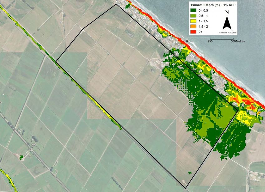
Contents
1 Project Background .................................................................................................................................... 1
            1.1         Introduction ............................................................................................................................... 1
            1.2         Proposed Development ............................................................................................................ 1
            1.3         Approach .................................................................................................................................. 2
            1.4         Report limitations ...................................................................................................................... 3

2 Site Setting ................................................................................................................................................... 4
            2.1         Site location and geomorphology ............................................................................................. 4
            2.2         Geological and hydrogeological setting.................................................................................... 4
                        2.2.1         Geological setting ...................................................................................................... 4
                        2.2.2         Hydrological and hydrogeological setting .................................................................. 5
            2.3         Seismicity ................................................................................................................................. 5

3 Natural Hazards ........................................................................................................................................... 7
            3.1         Introduction ............................................................................................................................... 7
            3.2         Volcanic Activity........................................................................................................................ 7
                        3.2.1         Ashfall ........................................................................................................................ 7
            3.3         Earthquakes ........................................................................................................................... 10
                        3.3.1         Liquefaction and lateral spread ............................................................................... 10
                        3.3.2         Tsunami ................................................................................................................... 11
            3.4         Coastal inundation and erosion .............................................................................................. 15
                        3.4.1         Coastal inundation ................................................................................................... 15
                        3.4.2         Coastal erosion ........................................................................................................ 16
            3.5         Extreme (prolonged or intense) rainfall .................................................................................. 16
                        3.5.1         Flooding ................................................................................................................... 16
            3.6         Summary of hazards .............................................................................................................. 18

4 Risk Assessment ....................................................................................................................................... 19
            4.1         Risk analysis and evaluation .................................................................................................. 19
            4.2         Risk treatment ........................................................................................................................ 21
                        4.2.1         Earthquake (liquefaction and lateral spread) .......................................................... 21
                        4.2.2         Tsunami ................................................................................................................... 21
                        4.2.3         Flooding ................................................................................................................... 22
                        4.2.4         Other ........................................................................................................................ 23
            4.3         Analysis and evaluation .......................................................................................................... 24

5 Conclusion ................................................................................................................................................. 26
6 References ................................................................................................................................................. 27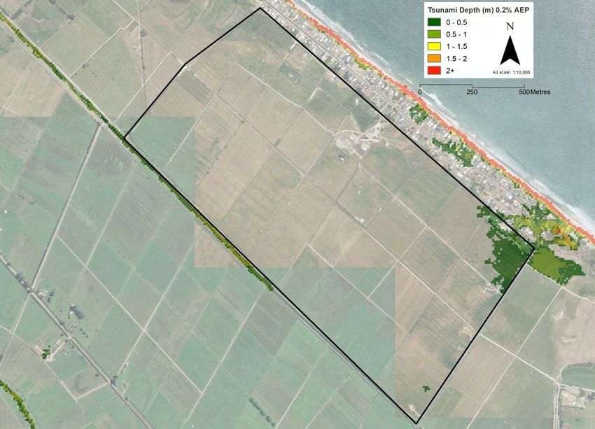
Appendices
Appendix A
          Site Plans

Appendix B
          ECoast Tsunami Maps

Appendix C
          Natural Hazard Risk Assessment

Figures
Figure 1         Site Location Plan (image from Western Bay of Plenty District Council 2011-2012)
Figure 2         Masterplan showing of mixed residential and ecological wetland habitat development
Figure 3         Volcanic ash fall zones for 100-year event
Figure 4         Volcanic ash hazard map (contours in mm) for 500-year return period (Hurst & Smith, 2010)
Figure 5         Liquefaction Hazard Map, the site is outlined in blue (from WBOP Lifelines Group, 2003)
Figure 6         Liquefaction Ground Damage Map, the site is outlined in blue (from WBOP Lifelines Group,
                 2003)
Figure 7         Modelled tsunami depth at the site for a 0.2% AEP event. Site boundary shown in black
                 (data provided by BOPRC, aerial photo from LINZ)
Figure 8         Modelled tsunami depth at the site for a 0.1% AEP event. Site boundary shown in black
                 (data provided by BOPRC, aerial photo from LINZ)
Figure 9         Modelled tsunami depth at the site for a 0.04% AEP event. Site boundary shown in black
                 (data provided by BOPRC, aerial photo from LINZ)
Figure 10        Coastal inundation hazard zones, the site is to the right (SE) of the map (from Tonkin &
                 Taylor, 2015)
Figure 11        Coastal erosion hazard zones, the site is shown in orange (from Tonkin & Taylor, 2015)
Figure 12        Flood hazard zone indicated in blue, the site is shown in green (from BOPRC)
Figure 13        Tsunami evacuation map, the site is shown in the blue box (from BOPRC)
Figure 14        Proposed flooding mitigation options (Aurecon, ref: 502328-0000-REP-CC-0000)

Tables
Table 1          Occurrence of natural hazards in the region (after RPS, 2016
Table 2          Likelihoods for risk assessment (from Appendix L, RPS, Table 20)
Table 3          Risk rating pre-development
Table 4          Risk rating post-development
Table 5          Risk rating pre- and post-development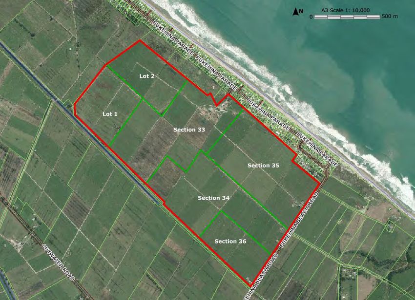
1            Project Background

1.1          Introduction
Property Seven Limited (the ‘Client’) have engaged Aurecon New Zealand Limited (Aurecon) to undertake a
Natural Hazards Risk Assessment (NHRA) of the Pukehina Eco-Village development. The study area,
currently comprising ~165 hectares (ha) of vacant pastoral grazing land and will be re-developed for low-
density residential lifestyle dwellings (137 in total) with adjoining specialised ecological wetland habitat. The
proposed development site (the ‘site’) is located 33 km southeast of Tauranga in the Pukehina township, on
the north-west side of Pukehina Beach Road between the Pukehina Canal and the township (Refer Figure
1). The approximate site boundary is shown in red and current land parcels in green.

Figure 1 Site Location Plan (image from Western Bay of Plenty District Council 2011-2012)

This NHRA is prepared to accompany Aurecon’s G1 geotechnical assessment report (502328-0002-REP-
GG-0001[3]). The report presents our interpretation of the natural hazards and risk and how the hazards are
being eliminated or managed to reduce the overall risk.

1.2          Proposed Development
A low-density residential development with specialised ecological habitat areas (refer to Figure 2). The
proposed ecological habitat will comprise two ponds, with a supporting network of public walkways and
cycleways. The balance of the site will be converted to residential land use, with up to 137 residential lots
2000 m2 in size on elevated fill platforms. To construct the proposed landform the site will be subject to cut
and fill earthworks. A masterplan sketch is presented in Figure 2.

                                                        Project number 502328 File 502328-0000-GG-0002[2].docx, 2019-04-08 Revision 2   1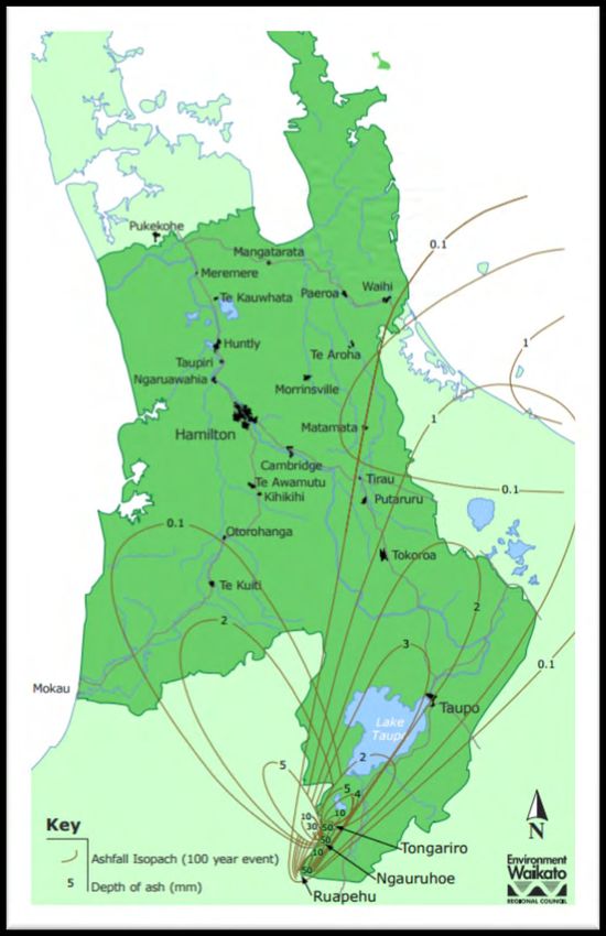
Figure 2 Masterplan showing of mixed residential and ecological wetland habitat development

The two wetland ponds are proposed, one 33.5 ha pond (maximum depth 6 m) occupying the northern half
of the site and a smaller 4.5 ha pond (maximum 4 m deep) in the southern portion of the site, adjacent to
Pukehina Beach Road. The ponds will be constructed at 0.55 m Reduced Level (m RL)1. The groundwater
table will be maintained at 0.55 m RL for the wetland ecosystem and habitat. The groundwater table and
surface water levels will therefore be controlled to remain static (accounting for sea level rise) over the
design life.
We understand that the Client wishes to use soils extracted from wetland pond excavation to raise the
residential land to a design level of ~4.2 m RL. The proposed dwellings will comprise detached lightweight
residential structures constructed in accordance with NZS:3604 2. Key lifeline services and utilities electricity,
effluent and stormwater will be provided onsite, as opposed to being connected to council systems. The built
infrastructure will be constructed at an elevation of 3.6 m RL or higher.
The preliminary landform design (Drawing 502328-0000-DRG-CC-0005[B]) and indicative cut and fill
contours (Drawing 502328-0000-DRG-CC-0020[B]) are presented in Appendix A.

1.3              Approach
The operative Regional Policy Statement (RPS) natural hazards provisions have been designed to influence
resource consents and the development of regional, city and district plans as they affect natural hazards.
The RPS was made operative in 2014, with Change 2 (Natural Hazards) merged into the RPS and made
operative from 6 July 2016. The proposed development does not include a plan change and as such is not
formally required to give effect to the provisions of the RPS. Section 104 of the Resource Management Act
(RMA) requires that for a resource consent, the development should “give regard” to the provision of the
RPS only. The RPS considers eight natural hazards; not all of the natural hazards are considered relevant to
the site.

1   Metres Reduced Level (m RL) relates to Vertical Datum Moturiki (1953)
2   New Zealand Standard 3604:2011; Timber Framed Buildings
                                                                   Project number 502328 File 502328-0000-GG-0002[2].docx, 2019-04-08 Revision 2   2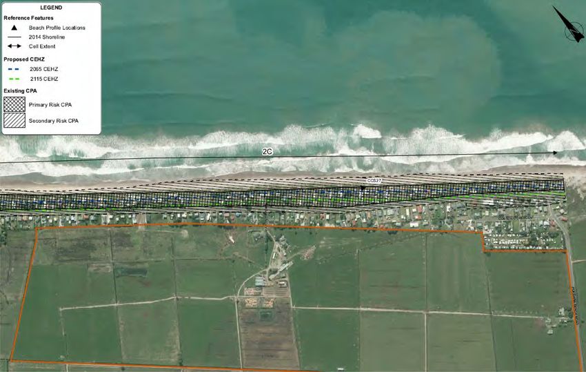
To support the resource consent application a NHRA has been requested by the Bay of Plenty Regional
Council (BOPRC) to assess the risk posed to the development from natural hazards, and identify the
mitigation measures proposed to limit the effect of the hazards to the built environment and reduce potential
harm to users (determined to be residents, and members of the public using the wetland for recreational
purposes. Giving regard to the RPS, and to meet the provision of the RPS, the following scope of works was
undertaken:
A desktop study, including but not limited to:
available geomorphological, geological and hydrological conditions;
a review of the Western Bay of Plenty District Council (WBOPDC) and BOPRC online hazard maps;
reports and maps pertaining to the hazards on the site from publicly available sources;
review of Aurecon’s G1 Geotechnical Assessment Report (ref: 502328-0002-REP-GG-0001[3]), noting
that the ground investigations were not completed to inform the NHRA. The NHRA was a later request
from BOPRC through the s92 process.
An assessment of existing natural hazards risks that affect the site, excluding those not relevant;
A qualitative risk assessment, completed in accordance with Appendix L of the RPS.
It should be noted that the NHRA does not supersede any process or function of the Building Act which also
gives provision to natural hazards and regulates building work through the Building Code to protect loss of
life and amenity.
1.4 Report limitations
This report has been prepared in accordance with the brief as provided. The scope of this work is limited to
meeting the provisions of the Bay of Plenty RPS. All other legislative statutes giving reference to natural
hazards and their mitigation shall be adhered to within their respective relevant frameworks. The contents of
the report are for the sole use of the Client. No responsibility or liability will be accepted to any third party.
Data or opinions contained within the report shall not be used in other contexts or for any other purposes
without prior written agreement of Aurecon New Zealand Limited.
Only a finite amount of information has been collected to meet the specific financial and technical
requirements of the Client’s brief and this report does not purport to completely describe all the site
characteristics and properties. This report is not to be reproduced either wholly or in part without prior written
permission from Aurecon New Zealand Ltd.
Project number 502328 File 502328-0000-GG-0002[2].docx, 2019-04-08 Revision 2 3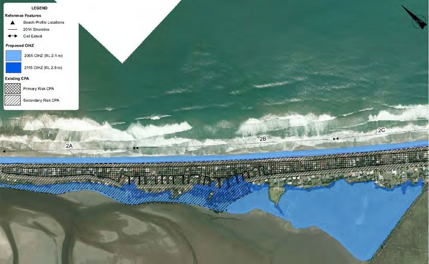
2 Site Setting
2.1 Site location and geomorphology
The site covers 165 ha of pastoral land and is bound by Pukehina Beach Road to the east, Pukehina Canal
to the south and residential properties to the north. The site is roughly rectangular in shape with dimensions
of approximately 1.9 km long and 1 km wide orientated north-west to south-east. The extent of the site is
defined by the drawings presented in Drawing 502328-0000-DRG-CC-0005[B], Appendix A.
There are six land parcels within the site, Section 33 – 36 BLK I Waihi South SD, Lot 1 DPS 51656 and Lot 2
DPS 65860, four of which contain residential dwellings and related farm buildings. Buildings include:
239 Pukehina Beach Road – A residential dwelling and a shed;
275 Pukehina Beach Road – A residential dwelling and shed. Approximately 75 m north, a farm shed and
cattle yards;
307 Pukehina Beach Road – A residential dwelling with multiple sheds;
2 Gardiner Place – A residential dwelling and to the south, several large farm sheds including a milking
shed.
The entire site is currently used for pastoral grazing / dairy. The land is low-lying and has a series of drains
which divert water into the Pukehina Canal and effluent ponds.
The site has a relatively flat topography, ranging in elevation from 0 – 2 m RL; the eastern and northern
areas of the site are marginally higher than that of the balance. There is evidence of minor earthworks, and
the land has been artificially risen to 2 m RL in places, including the stopbank along the Pukehina Canal.
It is situated on the coastal lowlands behind coastal dunes and approximately 0.2 km from the sand-dune
forefront and Pukehina Beach. The site adjoins an area to the north known as the “Pukehina Beach
Settlement” which is a strip of residential properties located on elevated sand dune land ridge along a 5.2 km
length of coastline which is raised to 2 – 12 m RL. To the east is Pukehina Beach Road and across of
Pukehina Beach Road is rural farmland, to the south and west is further rural farmland.
Topographic features in the wider area include, Waihi estuary 3 km northwest of the site, several alluvial
terraces located to the east (up to ~30 m RL), and to the north is a coastal dune system.
2.2 Geological and hydrogeological setting
2.2.1 Geological setting
The coastal Bay of Plenty (BOP) comprises a range of dunes, lagoons, swamps, estuaries and alluvial
regimes. Together with changing sea levels and volcanic eruptions in the Pleistocene and Holocene, this has
resulted in a thick sequence of soft and loose sediments and shallow groundwater.
The coastline has been transformed through marginal marine and alluvial processes. Streams and rivers
navigate through the area, transporting pumiceous tephras from Okataina and Taupo Volcanic centres to the
coast. Material has accumulated at river mouths and been transported along the coast via longshore drift;
leading to shoreline progradation and the formation of several low-lying alluvial plains along the BOP
coastline. The lithology in coastal BOP varies laterally and vertically and depicts the environmental
conditions at the time of deposition. Fluctuating sea level, migrating rivers and energy environments, has led
to heterogeneous packages of coarser and finer materials.
A review of the Institute of Geological and Nuclear Sciences (GNS) 1:250,000 geological map for Rotorua
(Leonard et. al., 2010) indicates the site to be underlain by Holocene Tauranga Group deposits described as:
dark brown to black organic mud, muddy peat and woody peat with minor overbank sand, silt and mud.
Towards the coast, the geology is comprised of coastal beach deposits, described as: marine gravel, sand and
mud on modern beach; these deposits have been mapped underlying the north-eastern edge of the site. These
Project number 502328 File 502328-0000-GG-0002[2].docx, 2019-04-08 Revision 2 4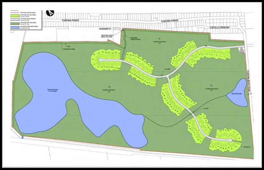
units are underlain by Quaternary alluvium, exposed to the east of the site, and described as: poorly to
moderately sorted gravel with minor sand and silt underlying terraces; includes minor fan deposits and loess.

A ground investigation was undertaken between the 26 March and 12 April 2018 by Aurecon to establish
ground and groundwater conditions across the site (refer to Aurecon’s Geotechnical Report; ref: 502328-
0002-REP-GG-0001[3]). Based on observed and inferred ground conditions, the site geology broadly reflects
the published setting; comprising surface topsoil, underlain a thick sequence of alluvial and estuarine soils
comprising a combination of silt, sand and gravel with interbedded organic layers.
The geology is divided into three main units comprising upper and lower alluvial units (predominantly
granular with lenses of soft silt and occasional peat horizons) separated by a layer of soft estuarine silt (with
occasional sand layers). The relationship with between the lower alluvial and estuarine units is complex, with
significant interbedding inferred. These units are capped by a thin layer topsoil or fill. It is anticipated that fill
earthworks have been completed along farm drains, and the Pukehina Canal. More detailed information on
the site ground conditions is included in Aurecon’s Geotechnical Report.

2.2.2             Hydrological and hydrogeological setting
There are no natural surface water bodies on the site. In the mid-1900s a land drainage scheme was put into
place which controlled flooding and allowed the conversion of flax growing land into pastoral land (Law,
2008). Several canals have been developed adjacent to the site, including the Kaikokopu, Wharere,
Pongakawa and Pukehina Canal which runs along the southern boundary of the site.
There are two main farm drains on site, and the site is actively pumped from a sump at its western boundary.
Water drains, and is pumped, into the Pukehina Canal to the south of the site and eventually discharge into
the Waihi Estuary approximately 2.5 km to the north west of the site. The pumping artificially lowers the
groundwater table on the site. Heavy rain fall events and seasonal changes may result in variations to
groundwater level and flow direction.
A search of the BOPRC well bore database identifies one historical well (reference number: BH-1218)
located at the north-eastern edge of the site. The bore is 36 m deep and water level recorded at 19.5 m bgl.
Nearby bores within the alluvial plain have recorded the groundwater closer to the surface.
Based on this information and the water level within adjacent drains and canals, the groundwater level is
anticipated to be shallow. This is confirmed by reported groundwater levels in Aurecon’s Cone Penetrometer
Tests (CPTs), hand augers and the rotary drilled borehole undertaken during ground investigation where
groundwater level ranges between 0.20 and 0.99 m below current surface level (refer to Aurecon’s
Geotechnical Report, ref: 502328-0002-REP-GG-0001[3]). In the test locations the groundwater was
measured in the same geological unit; beach sand / upper Alluvium. Hand auger boreholes collapsed, due to
the high-water content, between 1.2 and 2.2 m bgl.
A regional groundwater flow to the north can be expected, however shallow groundwater flow may be
affected by the artificial drains/canals, and the nearby Waihi Estuary.

2.3              Seismicity
A review of the New Zealand Active Fault Database 3 shows the nearest fault to the site, approximately 7 km
southeast, is the Otamarakau Fault. The Otamarakau Fault is a normal fault with unknown rupture
parameters. There are several more normal faults located approximately 14 km southeast of the site, and of
the faults that have been investigated, they have recurrence intervals of ≤ 2,000 years. The Otamarakau
Fault is not listed as a major fault in Table 3.6 of NZS:11704.

3   Data.gns.cri.nz. (2018). New Zealand Active Faults Database. [online] Available at: https://data.gns.cri.nz/af/ [Accessed Mar. 2018].
4   New Zealand Standard 1170.5:2005 Structural Design Actions, Part 5. Earthquake Actions – New Zealand.
                                                                      Project number 502328 File 502328-0000-GG-0002[2].docx, 2019-04-08 Revision 2   5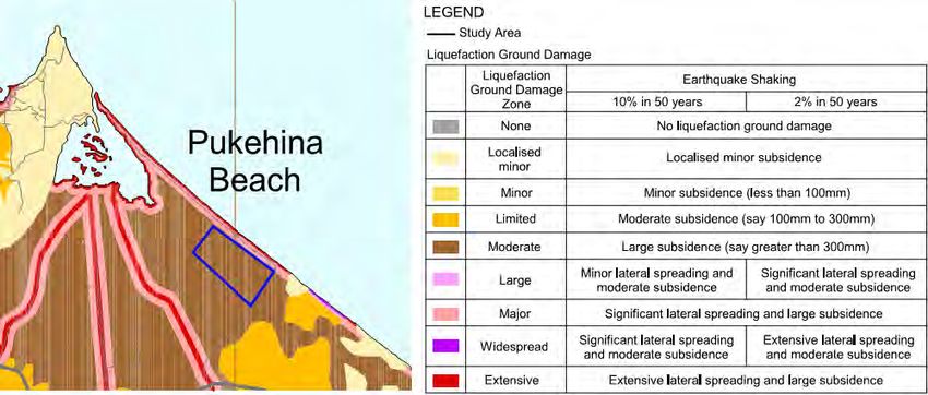
A number of active fault sources have been identified and used as inputs for the probabilistic seismic hazard
analysis (PSHA) (Stirling, et al. 2012). The site is within the Havre Trough – central Taupo Rift domain which
is the continental arc and back-arc of the Hikurangi subduction margin; the domain widens northward as it
transitions from the Taupo rift to the southern Havre Trough. There has been one major historical surface
rupturing earthquake on land, and potentially another earthquake. The 1987 Mw 6.5 Edgecumbe earthquake
ruptured the Edgecumbe fault, and several other nearby faults, and the 1992 Mw 6.3 Bay of Plenty
earthquake potentially ruptured a fault in the offshore Whakatane Graben (Stirling, et al. 2012).

                                                       Project number 502328 File 502328-0000-GG-0002[2].docx, 2019-04-08 Revision 2   6
3 Natural Hazards
3.1 Introduction
Our present understanding of natural hazards that may affect the site come from sources including:
Western Bay of Plenty hazard studies including liquefaction, flooding, coastal erosion and inundation, and
tsunami;
Site-specific investigations of stormwater and earthquake effects;
The Bay of Plenty Civil Defence Emergency Management (CDEM) Plan and the RPS identifies a wide range
of natural hazards that affect the region and are presented in Table 1, with the hazards that are most
relevant to the site shown in bold.
Table 1 Occurrence of natural hazards in the region (after RPS, 2016
Natural occurrence Resulting natural hazard
Volcanic activity Ash fall
Pyroclastic and lava flow
Landslip, debris flow and lahar
Geothermal hazard
Caldera unrest
Earthquakes Fault rupture
Liquefaction and lateral spread
Ground shaking
Landslide and rockfall
Tsunami
Coastal/marine processes Coastal inundation
Coastal erosion
Extreme (prolonged or intense) rainfall Flooding
Landslide
Debris flow/flood
Climate change will exacerbate natural hazards with weather patterns likely to bring more intense rain, result
in more frequent intensified flooding. Sea level rise could result in intensified coastal hazards, such as
erosion and storm surge, flooding and higher groundwater tables. Sea level rise effects not considered as
part of NHRA due to controls in place to artificially maintain at a relatively constant normal water level to
preserve wetland.
3.2 Volcanic Activity
3.2.1 Ashfall
At present, there is no published ash fall hazard information provided by regional and district councils for the
coastal Bay of Plenty. Waikato Regional Council (WRC) engaged the Institute of Geological and Nuclear
Sciences (GNS) to characterise the most relevant volcanic centres, along with the likely nature and extent of
fall out following an eruption. The depth of ashfall, using prevailing wind directions, was mapped for a 100-
year event and is presented in Figure 3.
Project number 502328 File 502328-0000-GG-0002[2].docx, 2019-04-08 Revision 2 7Figure 3 Volcanic ash fall zones for 100-year event5
Ash fall of between 0.1 to 1 mm could be expected for a 100-year event over the coastal Bay of Plenty.
Conversely, the ash fall isopachs from the New Zealand ash fall Probabilistic Volcanic Hazard Map (Figure 4,
Hurst & Smith, 2010) indicates that no ash fall would be expected in the coastal Bay of Plenty region from a
500-year event.
5Waikato Regional Council. Volcanic ashfall zones map: https://www.waikatoregion.govt.nz/services/regional-services/regional-
hazards-and-emergency-management/volcanic-activity/volcanic-ashfall-zones/
Project number 502328 File 502328-0000-GG-0002[2].docx, 2019-04-08 Revision 2 8Figure 4 Volcanic ash hazard map (contours in mm) for 500-year return period (Hurst & Smith, 2010) The consequences of between 0.1 to 5 mm of ash fall are (after Edbrooke, 2005):
3.3          Earthquakes

3.3.1        Liquefaction and lateral spread
The New Zealand Active Fault Database shows the nearest fault to the site, approximately 7 km southeast,
is the Otamarakau Fault. The Otamarakau Fault is a normal fault with unknown rupture parameters. There
are several more normal faults located approximately 14 km southeast of the site, which have recurrence
intervals of ≤ 2,000 years. The Otamarakau Fault is not listed as a major fault in Table 3.6 of NZS:1170.
The Western Bay of Plenty (WBOP) Lifelines Group Report (2003) indicates that the site is underlain by
material likely to undergo widespread liquefaction with the associated ground damage to be moderate with
approximately 300 mm of subsidence possible. Major to extensive lateral spreading and subsidence could be
expected adjacent to the adjacent rivers and canals. The hazard maps in relation to the site are presented as
Figure 5 and Figure 6.

Figure 5 Liquefaction Hazard Map, the site is outlined in blue (from WBOP Lifelines Group, 2003)

Figure 6 Liquefaction Ground Damage Map, the site is outlined in blue (from WBOP Lifelines Group, 2003)

Further investigation into the liquefaction and lateral spread hazards associated with earthquakes related to
the site were undertaken by Aurecon and reported in the Geotechnical Assessment Report (ref: 502328-
0002-REP-GG-0001[3].

                                                      Project number 502328 File 502328-0000-GG-0002[2].docx, 2019-04-08 Revision 2   10
Aurecon’s geotechnical investigation across the site indicates two different ground profiles with different earthquake responses. Loose to medium dense sand and silty-sand (Units 2 and 4 alluvial layers) encountered on site are considered to be potentially liquefiable from a soil character and density perspective. In situ materials with higher fines contents (Unit 3 – Estuarine silts) are considered non-liquefiable. For the ground penetrated by the CPT profiles this non-liquefiable cut-off is assumed to be where the Soil Character Index, Ic, is greater than 2.6. Any horizons of peat or gravel are not considered to be liquefiable. The groundwater table is currently recorded at between 0 and 1 m bgl, though the actual water level may be affected by active pumping to the Pukehina Canal. Anticipating that the sea level is expected to rise up to a level of 1.2 m RL over the next 50 years the groundwater table, for the purpose of this analyses is set at 0 m bgl for each CPT location. Residential building structures such as those proposed for this development are classified as Importance Level 2 structures in accordance with NZS1170. Based on the inferred geological model the site is considered likely to have a site subsoil category of Class D (deep soil sites) in accordance with NZS 1170. As the maximum level of investigation extends to 15 m bgl, with areas of softer ground noted to the maximum depth investigated, it is possible that area of the site may comprise Class E ‘very soft soils’. The possible extent of Class D and E soils requires further investigation as part of detailed design. Based on the results of analyses completed as part of the Aurecon’s assessment a 1 in 1000 year earthquake event (0.1%) exceeds the maximum credible (worst case) event for vertical settlement effects, which is considered to be the point at which the maximum amount of liquefaction can be achieved (based on our analyses determined to be within a 1/100 to 1/150 year return period; or 1% to 0.67% AEP), which equates to a peak ground acceleration of between 0.13 to 0.15 g for an IL2 structure. A ULS building code event (1 in 500 year, or 0.2% AEP; 0.26g) for an IL2 importance level structure in accordance with NZS1170 in line with existing uses also exceeds the maximum credible earthquake event. In the event of a 0.1%AEP earthquake event, a free field settlement of ~310mm is currently predicted. The site is not currently expected to be effected by lateral spread based on the current landform. It is noted that the construction of new ponds will create a situation where lateral spread hazard is created. The Geotechnical Assessment Report notes that in a 1 in 500-year event (Ultimate Limit State) a lateral spread effect in excess of 400 – 600 mm is conservatively predicted at the edges of the ponds, in the absence of specific controls put in place. Based on the results of analyses completed to date more significant lateral spreading effects would be expected in a 1 in 3,030-year event, required to be considered by RPS. 3.3.2 Tsunami Tsunami modelling has been undertaken of the Pukehina area for WBOPDC (ref: ECoast Report, June 2017) to identify areas susceptible to tsunami inundation hazard. The inundation extents were determined for four different probability levels based on the National Tsunami Hazard Model of Power (2013). These are the 0.2% AEP (500-year recurrence interval [RI]), 0.1% AEP (1000-year RI) 0.04% AEP (2500-year RI) and the Maximum Credible Event (MCE). Further detailed information on the methodology and results are included in the ECoast Report. For Pukehina during the Mean High Water Spring tide (WHWS) plus Sea Level Rise (SLR) scenario, the entire area is flooded prior to any tsunami activity due to the low-lying topography. The narrow strip of land remaining along the Pukehina Spit is overtopped in several places by the 0.2% AEP event and completely over run in the 0.04% AEP and MCE scenarios. For all scenarios, the tsunami flood depth at the current land form is
Figure 7 Modelled tsunami depth at the site for a 0.2% AEP event. Site boundary shown in black (data provided by BOPRC, aerial photo from LINZ)

                                                                                                                   Project number 502328 File 502328-0000-GG-0002[2].docx, 2019-04-08 Revision 2   12
Figure 8 Modelled tsunami depth at the site for a 0.1% AEP event. Site boundary shown in black (data provided by BOPRC, aerial photo from LINZ)
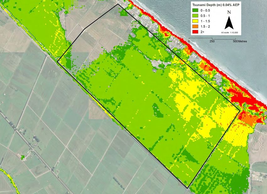
Project number 502328 File 502328-0000-GG-0002[2].docx, 2019-04-08 Revision 2 13Figure 9 Modelled tsunami depth at the site for a 0.04% AEP event. Site boundary shown in black (data provided by BOPRC, aerial photo from LINZ)
Project number 502328 File 502328-0000-GG-0002[2].docx, 2019-04-08 Revision 2 143.4 Coastal inundation and erosion
The online BOPRC and WBOPDC hazard maps were used to identify potential coastal erosion and
inundation hazards for the site. The Pukehina Coastline has been the subject of a detailed study to identify
land at risk to these coastal hazards over two timeframes: 0-50 and 50-100 years. The study findings are
reflected on the District Plan Maps through the identification of ‘Coastal Erosion Areas’ and ‘Coastal
Inundation Areas’.
Tonkin & Taylor (April 2015, ref: 851833) assessed the coastal hazard extent based on a method developed
by Healy (1993), where both coastal erosion and inundation hazard have been assessed. Two timeframes
were applied: 1) 50 year, and 2) 100 year.
3.4.1 Coastal inundation
The Coastal Inundation Hazard Zone (CIHZ) was assessed over a 50 year and 100-year timeframe for
Pukehina (Figure 10). The CIHZ was based on an inundation level derived from the combination of the
following components:
Storm tide;
Wave set-up;
Wind set-up;
Sea level rise.
The inundation components were calculated for the estuary coast environment at Pukehina (inner spit
shoreline). The 2065 and 2115 CIHZ identify land susceptible to coastal inundation hazard over a 50 and
100-year planning timeframe respectively. The foredune heights at Pukehina are sufficient to mitigate any
inundation hazard from the open coast, therefore the site is not affected by coastal inundation hazards.
Figure 10 Coastal inundation hazard zones, the site is to the right (SE) of the map (from Tonkin & Taylor, 2015)
The assessment undertaken identifies that coastal inundation hazards do not affect the site, and therefore
have not been considered further in the risk assessment.
Project number 502328 File 502328-0000-GG-0002[2].docx, 2019-04-08 Revision 2 153.4.2 Coastal erosion
The Coastal Erosion Hazard Zone (CEHZ) methodology used combines standard and well-tested
approaches for defining coastal erosion hazard zones. The resulting distribution is a probabilistic forecast of
potential hazard zone width. The method is further discussed in the Tonkin & Taylor Report. The 50-year
CEHZ values for Pukehina range from 30 to 40 m, and from 50 to 80 m for the 100-year CEHZ (Figure 11).
Figure 11 Coastal erosion hazard zones, the site is shown in orange (from Tonkin & Taylor, 2015)
The assessment undertaken identifies that coastal erosion hazards do not affect the site, and therefore have
not been considered further in the risk assessment.
3.5 Extreme (prolonged or intense) rainfall
3.5.1 Flooding
The online BOPRC flood hazard map to identifies a flood hazard applicable to the site (Figure 12). The flood
mapping was derived from the Pukehina Catchment Management Plan - Floodable Areas Maps (Duffill Watts
and King, 2006).
The annual exceedance probability (AEP) used was 2% (i.e. equivalent to a 50-year return period) to
determine potential areas of flooding.
Project number 502328 File 502328-0000-GG-0002[2].docx, 2019-04-08 Revision 2 16Figure 12 Flood hazard zone indicated in blue, the site is shown in green (from BOPRC)
Further investigation into the flood hazards related to the site was undertaken by Aurecon and reported in
the Stormwater and Services Assessment (ref: 502328-0000-REP-CC-0000).
The site is part of the catchment of the Pukehina Canal which runs alongside the full length of the south-
western boundary and drains to the estuary. The site is connected to the canal by a flood pump located in
the western corner of the block adjacent to the canal. There is no direct connection to the canal as there is a
stopbank running the full length of the site to the estuary with the crest level at between RL 1.75 m and RL
2.0 m approximately. The canal is tidally affected but with a narrow tidal range from approximately RL 0.3m
to RL 1.0m based on measurements taken between 15th and 19th March 2018.
Land drainage pumps maintain a lower level of water within the internal land drains than the water levels
within the canal. The catchment to the single drainage pump includes the site, the Pukehina Parade
properties and road over the length of the site, and approximately 140 ha of upstream rural property – a total
catchment of approximately 330 ha. A further drainage pump at the eastern extent of the Pukehina Canal
services a further 140 ha of rural and residential land. These pumps are linked with a common central drain
and during periods of extended rainfall, when flooding extends over the pastures, the two pumpstations will
work together to lower the surface flooding. Approximately 46 ha of the upstream property is a continuation
of the low-lying flood plain similar to the site with a network of farm drains providing connection to the culvert
under Pukehina Beach Road for flood drainage and also to maintain lower ground water levels
To determine the flood levels and flows a simplified stormwater model using Mike-Urban was developed to
assess the impact in a 100-year event. The rainfall was input in a nested storm pattern which provides peak
flows and maximum volumes for the range of durations within a 48-hour period. Rainfall depths included for
3°C of climate change in line with BOPRC’s Stormwater Management Guidelines for the Bay of Plenty
region. The flood model also assumed no discharge out of the paddock areas to the Pukehina Canal (i.e. the
pumps are not operating).
The 100-year flood level over the site is RL 1.07m and extends beyond the existing site boundaries and
covers the upstream and downstream farm properties, and the lower yard areas of the existing urban
properties at 28 and 42 Pukehina Parade, and a portion of the Pukehina Campground. The ground level
within the rural land is typically between RL 0.6 and RL 0.9m. Upstream of Pukehina Beach Road, the
modelled 100-year flood level is RL 1.28 m. The capacity of the existing 1050 mm diameter culvert under the
road also restricts the volume transfer required to balance the flood levels across the Pukehina Beach Road
during the 100-year rainstorm event. The Pukehina Canal is separated from the site by a stopbank crest that
is between RL 1.75 m and RL 2. 0 m adjacent to the site and above RL 1.5 m upstream of Pukehina Beach
Road.
Project number 502328 File 502328-0000-GG-0002[2].docx, 2019-04-08 Revision 2 17A greater level of flooding in a secondary event required by RPS cannot currently be achieved as the larger
events will fill across the large floodplain and not be localised to the site and neighbouring properties. It is
considered likely that the 0.2% AEP rainfall event will cover the area to a level greater than the stopbanks
along the drainage canals (approximately 2.0m RL). This has not been modelled by the Regional Council, or
District Council, to our knowledge.
However due to the large floodplain area, relative to the total catchment area, and the direct connection to
the tidal estuary the 0.2% AEP rainfall event is not considered to be significantly higher than the 1% AEP
rainfall event and therefore would still be expected to be lower than the tidal inundation hazard. The increase
in rainfall between the 1% and 0.2% AEP rainfalls for a 24hour duration event is about 175 mm. This would
lead to an approximate increase in flood level of 300-400 mm only.
3.6 Summary of hazards
After consideration of the natural hazards presented in Table 1, included in Section 2.11 of the RPS, and
discussed in the subsections above, the following natural hazards will be assessed using the RPS risk
assessment methodology (refer to RPS, Appendix L):
Liquefaction and lateral spread;
Tsunami;
Flooding.
Project number 502328 File 502328-0000-GG-0002[2].docx, 2019-04-08 Revision 2 184 Risk Assessment
4.1 Risk analysis and evaluation
A NHRA has been undertaken for the site in line with the BOPRC RPS and natural hazard risk management
policy framework for development proposals; this includes identifying the risk, risk analysis and evaluation,
and risk treatment.
A discussion of hazards relative to the region are presented in Section 3 and on evaluation the following
hazards have been assessed specific to the site:
Liquefaction and lateral spread;
Tsunami;
Flooding.
Aurecon has undertaken a qualitative evaluation as per steps 1 to 4 of Appendix L of the RPS. Where
required, secondary analysis has been qualitatively evaluated. Step 5 of the methodology has not been
followed as this is requirement for calculating the Annual Individual Fatality Risk (AIFR). Calculation of the
AIFR is inappropriate for this site as the hazard consequences only relate to building and lifeline functionality
rather than health and safety risks post-development.
The following likelihoods for risk assessment were considered (Table 2):
Table 2 Likelihoods for risk assessment (from Appendix L, RPS, Table 20)
Natural Hazard Likelihood for initial analysis Likelihood for secondary analysis
AEP (%)1 AEP (%)1
Earthquake (liquefaction and lateral 0.1 0.2
spread)
0.033
Tsunami 0.1 0.2
0.04
Flooding 1 2
0.2
1
Probability (in terms of % AEP) (Refer Appendix L of RPS, Table 20)
The risk assessment and evaluation undertaken pre-development is included as Table C1 in Appendix C,
with a discussion of the qualitative consideration and the effects of the hazard on the current site users. A
summary is presented in Table 3.
Table 3 Risk rating pre-development
Natural Hazard Overall risk rating1 (AEP2 vs. consequence3)
Earthquake (liquefaction and lateral spread) High Risk
Tsunami Medium Risk
Flooding High Risk
1
Refer to Risk Screening Matrix, page 374 of RPS
2
Probability (in terms of % AEP) (Refer Appendix L of RPS, Table 20)
3
Consequences (Refer Appendix L of RPS, Table 21,)
Project number 502328 File 502328-0000-GG-0002[2].docx, 2019-04-08 Revision 2 19A key consequence governing the outcomes of the risk assessments completed relates to the functionality of
buildings in a post-event scenario. The performance requirement of the RPS considers is the likelihood of
relevant buildings or structures being “functionally compromised” as a result of the earthquake event under
consideration. Functionally compromised is defined by the RPS as a condition that “will generally occur when
a building cannot continue to be used for its intended use immediately after an event.” Outside of the RMA
framework, the Building Code objective B1.1(b) states that a building is to have a low probability of “loss of
amenity” during its life, which is defined as “an attribute of a building which contributes to the health, physical
independence and well-being of the building’s user but which is not associated with disease or a specific
illness.”
This concept is considered further in MBIE (2012), which ensures that amenity is maintained by ensuring that
“all parts of the structure shall remain functional so that the building can continue to perform its intended
purpose. Minor damage to structure. Some damage to building contents, fabric and lining. Readily
repairable. Building accessible and safe to occupy. No loss of life. No injuries.” On this basis, we make the
assumption that buildings design in accordance with this guideline will remain habitable in an immediate post
event scenario. With on-site provision of lifeline utilities, as opposed to reliance on a less resilient network we
could anticipate that amenity will be maintained to some degree in this scenario.
Therefore, for the purpose of this report, we interpret “functionality compromised” as being equivalent to the
loss of amenity definitions set out by MBIE. The term “readily repairable”, is defined by MBIE as a building
that can be repaired without relocation of occupants for a period of more than four weeks. On this basis, we
interpret that a functionally compromised building is one that cannot be repaired within four weeks.
In a pre-development scenario covered by Table 3 (referencing Table C1, Appendix C) the high risk and
medium risk ratings are in part due the catastrophic and major consequences of buildings which are old and
not likely to have been constructed in accordance with the current building code and industry best practice.
With four of the existing residences on the site at least 25% functionally compromised during a tsunami and
at least 50% functionally compromised due to liquefaction, lateral spread and flooding. Further discussion is
included in Table C1 in Appendix C.
In undertaking the risk assessment and evaluation for the post-development scenario, the following
assumptions were made:
Volcanic hazards, fault rupture, landslips excluded from natural hazard assessment in agreement with
BOPRC;
Modelling indicates that the site is not impacted by coastal erosion and coastal inundation, therefore risk
assessment not completed for these hazards (refer to Tonkin & Taylor, April 2015, ref: 851833);
Earthquake shaking is outside of the requirements of the RPS (but covered by the Building Code);
Ash fall hazard for the site is not well-defined, and therefore not be considered further. Furthermore, the
effect of ash fall on buildings and infrastructure is not considered in the New Zealand Building Code or
other relevant codes pertaining to the proposed development;
Calculation of the individual fatality risk as per Appendix L is inappropriate for this site as the hazard
consequences only relate to building and lifeline functionality rather than health and safety risks;
The consequences were considered in the Table 21 in Appendix L of the RPS, and with reference to the
Tonkin & Taylor (2018) Lifelines Consequence Assessment (ref: 1003468.vE).
Further assessment has been undertaken taking into account the risk treatment options below as part of the
site development (refer to Section 4.3).
Project number 502328 File 502328-0000-GG-0002[2].docx, 2019-04-08 Revision 2 204.2 Risk treatment
The following treatments are proposed during site development and will mitigate the natural hazard risk to
the site. Further discussion is also included as Table C2 in Appendix C.
4.2.1 Earthquake (liquefaction and lateral spread)
As a result of Aurecon’s geotechnical assessment, it is considered that the site would be unavailable for
residential development without any modification, ground improvement or engineering intervention. A
summary of the risk treatment options is presented below, with further details discussed in Table C2
(Appendix C), and within Aurecon’s Geotechnical Report:
Buildings will be standalone detached structures within large lots. Buildings shall be no greater than two
stories in height, with use of lightweight cladding and roofing materials to be recommended;
Foundations will be designed to meet TC2 ground performance requirements which can cope with a
maximum displacement of 100 mm vertically or laterally under very high levels of shaking without causing
significant superstructure damage. Structural collapse is unlikely to occur provided foundations remain
tied together. Following guidance and objectives related to loss of amenity (as set out within MBIE, 2012)
foundations designed in accordance with this guideline shall ensure that structures remain habitable and
readily repairable, thus maintaining functionality and amenity. With potential for further loss of amenity
reduced by implementation of on-site utilities;
Tilting and differential settlement may occur but TC2 type foundations are able to cope with differential
settlement as they are well tied together and can cantilever and span over sunken ground. Services
connections can be readily repaired at the slab edges/boundaries;
The building platforms will comprise at least 4m of compacted non-liquefiable fill and create a 'crust' that
will reduce the impact of differential settlement arising from reconsolidation settlement. An intact 3m+
thick crust will provide sufficient robustness to support the building and prevent any significant damage to
services (as observed from the Canterbury Earthquake Sequence);
We consider that surface ejection of liquefied material through the crust is unlikely to occur even at
maximum considered shaking intensities;
The building platforms will be either sufficiently set back from any free edges to be affected by lateral
spreading, or specific ground modifications or improvement will be provided at subdivision development
stage;
All horizontal infrastructure will be designed to cope with the expected differential settlement and use
modern materials that are able to cope with vertical and horizontal deformations.
4.2.2 Tsunami
A summary of the risk treatment options is presented below, with further details discussed in Table C2
(Appendix C), and within Aurecon’s Stormwater Assessment:
Built infrastructure will be constructed at an elevation of 3.5 m RL or higher, and the design level for the
construction of the proposed residential building platforms is currently 4.2 m RL, which is above the
modelled tsunami level of 1.5 to 2.4 m RL for both a 0.1% AEP and 0.04% AEP event;
A catchment separation bund height is proposed at RL 2.2 m. The level of the bund is lower than depth of
the modelled 0.1% AEP tsunami and maybe overtopped at the current design height. The tsunami will not
overtop the built infrastructure and residential building platforms and likely to be funnelled into the
wetlands;
Built infrastructure functionality will be increased further using standalone site-specific utilities (solar
panels, rain collection systems and on-site effluent disposal) thus not reliant on the existing network;
Additional mitigation measures include tsunami evacuation route signage for residents.
Project number 502328 File 502328-0000-GG-0002[2].docx, 2019-04-08 Revision 2 21 The site is located within the orange evacuation zone (Figure 13); a tsunami from regional or distant
sources (further away than 1000 km) could take anywhere from 2 to 12 hours to arrive. The yellow
zone represents an area impacted by the most devastating tsunami. After a major earthquake it would
take about 50 minutes for this tsunami to reach the coast, and approximately another 30 minutes to
flood the yellow zone.
The nearest “safe zone” as indicated by tsunami hazard mapping and evacuation zones is located
approximately 1.2 km southwest along Pukehina Beach Road, or 500 m east of the site. These
locations are less than a 15-minute walk from the site and therefore the site would be evacuate-able.
Figure 13 Tsunami evacuation map, the site is shown in the blue box (from BOPRC)
4.2.3 Flooding
A summary of the risk treatment options is presented below, with further details discussed in Table C2
(Appendix C), and within Aurecon’s Stormwater Assessment:
Approximately 40 ha of area will be elevated to create raised lot and access area platforms;
The built infrastructure will be constructed at an elevation of 3.5 m RL or higher, and the design level for
the construction of the proposed residential building platforms is currently 4.2 m RL, which is above the
expected ground water level of RL 0.6 m to RL 1.0 m, and an internal 100-year flood level of RL 1.31 m;
Water reticulation is not affected by flooding, and sttormwater will function again after the flood is gone.
Power will be related to transformers only that need to be elevated above RL3.5 which is fine;
The built infrastructure and building platform levels will also be above the Tauranga Harbour Inundation
Levels the RCP 8.5 H+ value (the BOPRC Policy on this matter is yet to be finalised);
Stormwater, wastewater and effluent will be managed on-site, and essential services will be elevated
above the flood level (i.e. at least RL 3.5m). Each lot will install rainwater tanks for irrigation and possible
potable uses. The single watermain supplying water for firefighting purposes is likely to be adjacent to
access roading into the proposed development, which will also be raised above the flood level;
The area outside of the building platform and lot areas are proposed to be lowered to allow a combination
of shallow wetland areas, above water zones for different species, and deep-water zones within the site;
Project number 502328 File 502328-0000-GG-0002[2].docx, 2019-04-08 Revision 2 22 The bund will be constructed around the site to protect the external properties from flooding from within
the site. The bund will also protect adjacent properties;
Modelling shows that the site can accommodate increases in water levels within the site and is separated
from the surrounding land by a bund so that external flood levels are not increased. The catchment
separation bund height is proposed at RL 2.2 m (refer to Figure 14). The modelling has also shown that
the construction of a bund will decrease the flood levels on the surrounding properties for many storm
scenarios;
The site will be separated from the existing land drainage pump that maintains a depressed water level
within the drains; this will enable the normal water level within the site to be managed to a consistent level
that is more appropriate for the final wetland design, and does not rely on mechanical systems to
maintain the proposed hydrological regime;
During detailed design, a longer period of canal water level and tidal level measurements will enable the
final levels of the inflow weir and outflow floodgates to be more accurately determined to achieve the
volume of tidal inflow and outflow and flood release to maintain a healthy wetland.
Figure 14 Proposed flooding mitigation options (Aurecon, ref: 502328-0000-REP-CC-0000)
4.2.4 Other
The following considerations are also made for reducing the natural hazard risk on the site:
The current proposed minimum floor level maintains a compliant freeboard from estuary inundation
levels;
BOPRC advised (ref: email from Pam Crabbe dated 11 March 2019) that in the current study on
Tauranga Harbour Inundation Levels the RCP 8.5 H+ value adopted is 1.6 m. This increases the design
1% AEP level for this development to around 4.0 m. The BOPRC Policy on this matter is yet to be
finalised however, the proposed minimum Building Platform Level of 4.2 m RL is above this level;
Project number 502328 File 502328-0000-GG-0002[2].docx, 2019-04-08 Revision 2 23 Groundwater table is to be controlled to be in the order of 0.55 m to 0.65m RL for the wetland. The
current design for the eco-village and wetlands will control the water levels on the site (including sea level
rise) to ensure that the ground/surface water control mechanisms work, and are in place. Increases in
wetland level will be in response to a rainfall event or a significant tide event which is managed by the
significantly elevated Building Platform level;
Due to the shallow groundwater table, the final earthworks design will incorporate separation and
drainage layers under fills;
Stormwater, wastewater and effluent will be managed on-site so there is no impact on the public services.
In addition, Aurecon’s Stormwater Assessment found that the proposed development will have a less
than minor effect on the public water supply and a negligible effect on any public stormwater or
wastewater system;
Each lot will install rainwater tanks for irrigation and possible potable uses, reducing demand on the
Council potable supply compared with conventional residential developments. A single watermain
supplying water for firefighting purposes and a trickle feed in periods of drought if required;
Aurecon’s Traffic Assessment (ref: 502328-0006-REP-CC-0001) found the proposed development
complies with the Western Bay of Plenty District Plan traffic requirements and the impact to the existing
key intersection of SH2/Pukehina Beach Road results in minimal change in level of service. The New
Zealand Transport Agency (NZTA) considered the proposed development and does not have any
concerns regarding the capacity of the Pukehina Beach Road / SH2 intersection. The analysis used was
conservative, having used 150 dwellings as opposed to the 137 in the development proposal and
assuming that all are permanent residents.
4.3 Analysis and evaluation
Further assessment considering the risk treatment options above is presented in Table 4. Further
assessment has been undertaken taking into account the risk treatment options below as part of the site
development. Calculation of the individual fatality risk as per Appendix L is inappropriate for this site as the
hazard consequences only relate to building and lifeline functionality.
Table 4 Risk rating post-development
Natural Hazard Overall risk rating1 (AEP2 vs. consequence3)
Earthquake (liquefaction and lateral spread) Low Risk
Tsunami Low Risk
Flooding Low Risk
1
Refer to Risk Screening Matrix, page 374 of RPS
2
Probability (in terms of % AEP) (Refer Appendix L of RPS, Table 20)
3
Consequences (Refer Appendix L of RPS, Table 21,)
Further discussion is included in Table C1 in Appendix C.
In undertaking the risk assessment and evaluation, the following assumptions were made:
Volcanic hazards, fault rupture, landslips excluded from natural hazard assessment in agreement with
BOPRC;
Modelling indicates that the site is not impacted by coastal erosion and coastal inundation, therefore risk
assessment not completed for these hazards (refer to Tonkin & Taylor, April 2015, ref: 851833);
Earthquake shaking is outside of the requirements of the RPS;
Ash fall hazard for the site is not well-defined, and therefore not be considered further. Furthermore, the
effect of ash fall on buildings and infrastructure is not considered in the New Zealand Building Code or
other relevant codes pertaining to the proposed development;
Project number 502328 File 502328-0000-GG-0002[2].docx, 2019-04-08 Revision 2 24You can also read