INTEGRATED TRANSPORT ASSESSMENT - Silk Road Management Limited Foodstuffs North Island Limited Proposed mixed-use development 360 Dominion Road ...
←
→
Page content transcription
If your browser does not render page correctly, please read the page content below
Silk Road Management Limited
                      Foodstuffs North Island Limited
                       Proposed mixed-use development

                    360 Dominion Road, 88 Prospect Terrace
                        and 113 Grange Road, Auckland

                   INTEGRATED TRANSPORT ASSESSMENT

Ref: 16316-r2v11
19 April 2021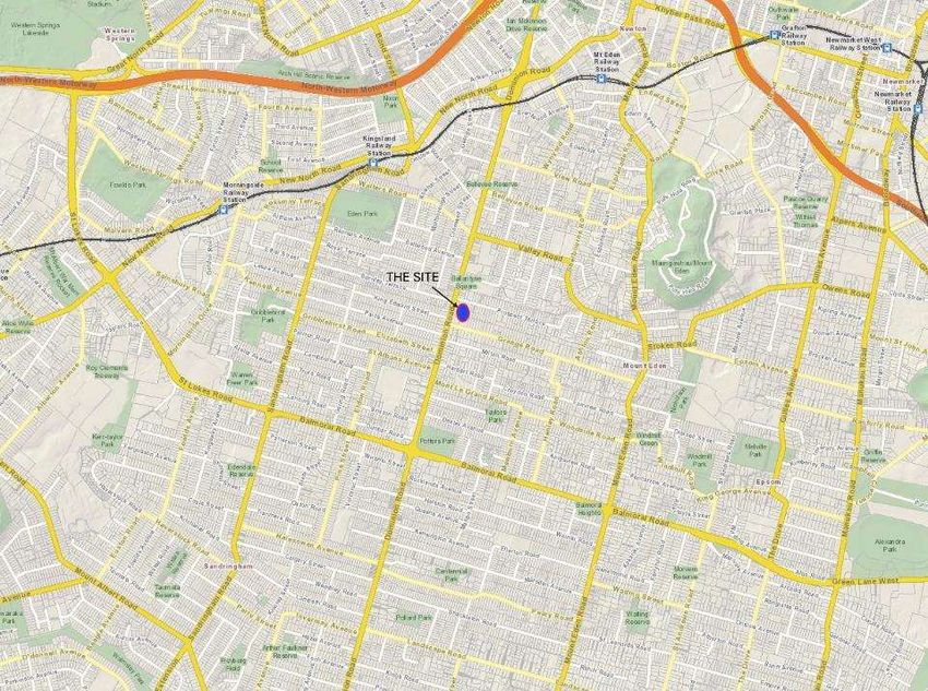
Silk Road Management Limited
Foodstuffs North Island Limited

Proposed mixed-use development

360 Dominion Road, 88 Prospect Terrace
and 113 Grange Road, Auckland

Integrated Transport Assessment

Prepared by: Todd Langwell and John Burgess

Directors
Traffic Planning Consultants Ltd

Ref: 16316-r2v11
19 April 2021

                                                                      Auckland Office:
                                                P O Box 60-255, Titirangi, Auckland 0642
                                              Level 1, 400 Titirangi Road, Titirangi Village
                                                                        Tel: (09) 817 2500
                                                                        Fax: (09) 817 2504
                                                                www.trafficplanning.co.nz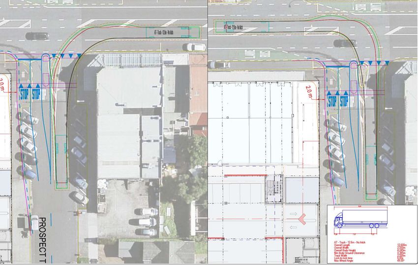
Contents
EXECUTIVE SUMMARY
1. Introduction……………………………………………………………………………………... 1
2. The transport planning context……………………………………………………………….. 2
2.1 - Site location………………………………………………………………………………………………………… 2
2.2 - General accessibility to travel modes……………………………………………………………………………. 4
2.2.1 - The road network…………………………………………………………………………………………… 4
2.2.2 - Public transport services…………………………………………………………………………………… 5
2.2.3 - Walking………………………………………………………………………………………………………. 5
2.2.4 - Cycling……………………………………………………………………………………………………….. 7
3. The transport environment……………………………………………………………………. 8
3.1 - Existing road environment……………………………………………………………………………………….. 8
3.2 - Existing public transport environment…………………………………………………………………………… 13
3.3 - Existing pedestrian environment…………………………………………………………………………………. 15
3.3.1 - Dominion Road……………………………………………………………………………………………... 15
3.3.2 - Prospect Terrace……………………………………………………………………………………………. 16
3.3.3 - Grange Road………………………………………………………………………………………………… 18
3.4 - Existing cyclist environment………………………………………………………………………………………. 19
3.5 - Existing traffic flows………………………………………………………………………………………………… 19
3.6 - Safety records……………………………………………………………………………………………………… 21
4. The proposed development………………………………………………………………….. 23
4.1 - Proposed activities on the site…………………………………………………………………………………… 23
4.2 - Proposed site layout………………………………………………………………………………………………. 23
4.3 - Proposed access arrangements………………………………………………………………………………….. 25
4.4 - Parking provision…………………………………………………………………………………………………… 25
5. Travel characteristics of the proposed development……………………………………….. 26
5.1 - Travel modes and locational characteristics……………………………………………………………………. 26
5.2 - Trip generation predictions……………………………………………………………………………………….. 26
5.3 - Trip distribution and assignment………………………………………………………………………………… 27
5.4 - Predicted traffic flows……………………………………………………………………………………………… 28
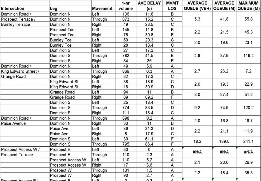
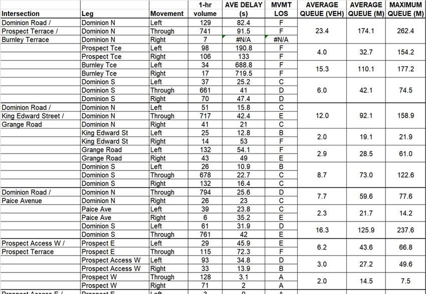
6. Transport modelling……………………………………………………………………………. 29
6.1 - Traffic model for existing transport environment………………………………………………………………. 29
6.2 - Traffic model with proposed mixed-use development – PM peak model…………………………………… 32
6.2.1 - Scenario A…………………………………………………………………………………………………… 32
6.2.2 - Scenario B…………………………………………………………………………………………………… 34
6.2.3 - Scenario C…………………………………………………………………………………………………… 36
6.2.4 - Scenario D…………………………………………………………………………………………………… 37
6.3 - Traffic model with proposed mixed-use development – Saturday peak model…………………………….. 39
6.3.1 - Scenario A…………………………………………………………………………………………………… 39
6.3.1 - Scenario B…………………………………………………………………………………………………… 40
6.3.1 - Scenario D…………………………………………………………………………………………………… 42
7. Effects and mitigation………………………………………………………………………….. 44
7.1 - Effects on the road network close to the site…………………………………………………………………… 44
7.2 - Effects on the wider road network……………………………………………………………………………….. 46
7.3 - Effects on pedestrian and cyclist accessibility, safety and amenity…………………………………………… 47
7.4 - Effects on the public transport network operation and use…………………………………………………… 48
7.5 - Effects on general traffic operation on Dominion Road……………………………………………………….. 49
7.6 –Promotion of alternative modes……………………….……………………………………………………….. 49
7.7 - Travel demand management strategy…………………………………………………………………………… 50
8. Wider transport planning context…………………………………………………………... 51
9. Auckland Unitary Plan Assessment………………………………………………………….. 53
9.1 - Section E27 - Transport Objectives and Policies……………………………………………………………… 53
9.2 - Section E27 - Transport Rules…………………………………………………………………………………… 55
Ref: 16316-r2v11– Integrated Transport Assessment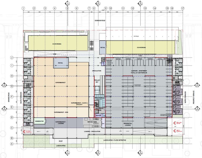
9.3 - Section E27 - Transport assessment criteria……………………………………………………………………                         59
 10.        COVID-19 recovery (Fast Track Consenting)…………………………………………………                                        61
 11.        Conclusions……………………………………………………………………………………….                                                       62

List of Figures
Figure 1           Site location                                                                                      2

Figure 2           Site in the context of the Auckland Unitary Plan zoning                                            3
Figure 3           Site in relation to surrounding activities                                                         4
Figure 4           Current bus services in the vicinity of the site                                                   5
Figure 5           400m walking contour from the site                                                                 6
Figure 6           1km walking contour from the site                                                                  6
Figure 7           3km cycling contour from the site                                                                  7

Figure 8           Dominion Road and Prospect Terrace - existing layout                                               8
Figure 9           Dominion Road looking to the north from Prospect Terrace                                           9
Figure 10          Dominion Road looking to the south from Prospect Terrace                                           9
Figure 11          Prospect Terrace looking to the east                                                              10
Figure 12          Prospect Terrace looking to the west                                                              10
Figure 13          Dominion Road and Grange Road - existing layout                                                   11
Figure 14          Dominion Road looking to the north from Grange Road                                               11
Figure 15          Dominion Road looking to the south from Grange Road                                               12
Figure 16          Grange Road looking to the east                                                                   12
Figure 17          Grange Road looking to the west                                                                   13
Figure 18          Southbound bus stop, south of Prospect Terrace, looking to the north                              14
Figure 19          Southbound bus stop looking to the south                                                          14
Figure 20          Northbound bus stop, north of Burnley Terrace                                                     15
Figure 21          Existing footpath along eastern side of Dominion Road along the site frontage                     15
Figure 22          Existing footpath along eastern side of Dominion Road near the Grange Road intersection           16
Figure 23          Existing footpath at the pedestrian signals                                                       16
Figure 24          Existing footpath along the southern side of Prospect Terrace                                     17
Figure 25          Existing footpath along the southern side of Prospect Terrace at existing vehicle crossing        17
Figure 26          Existing footpath along northern side of Grange Road                                              18
Figure 27          Existing vehicle crossings along northern side of Grange Road                                     18
Figure 28          "Quiet" cycling routes either side of Dominion Road                                               19
Figure 29          Existing traffic flows - Thursday 1600-1900 peak period                                           21
Figure 30          Existing traffic flows – Saturday 1100-1400 period                                                21
Figure 31          NZTA Crash Records - 2015-2020                                                                    22
Figure 32          Proposed site layout - Level 00                                                                   24
Figure 33          Proposed site layout - Level 01                                                                   24
Figure 34          Predicted traffic flows - Thursday 1700-1800 peak hour                                            28

Ref: 16316-r2v11– Integrated Transport Assessment
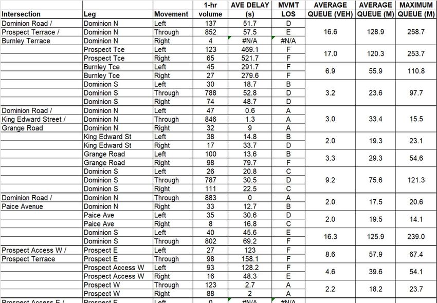
Figure 35         Predicted traffic flows - Saturday 1200-1300 peak hour                                            28
 Figure 36         Extent of traffic model                                                                           29
 Figure 37         Proposed changes to the Grange Road and Prospect Terrace intersections                            45
 Figure 38         Typical tracking paths of large rigid truck turning into Prospect Terrace                         45
 Figure 39         Typical hourly trading pattern for a New World supermarket                                        46

List of Tables
Table 1          Traffic flows on Dominion Road between Valley Road and Bellwood Avenue                              19
Table 2          Traffic flows on Grange Road between Dominion Road and Henley Road                                  20
Table 3          Trip generation rates – vehicles/hour                                                               26
Table 4          Predicted customer trip distribution                                                                27
Table 5          Model results for existing traffic flows + consented development not yet constructed – PM peak      31
Table 6          Model results for existing traffic flows + consented development not yet constructed – Saturday     31
Table 7          Model results with development – PM peak – Do nothing option                                        33
Table 8          Model travel times with Development - PM peak – Do nothing option                                   33
Table 9          Model results with development – PM peak – Do minimum option                                        35
Table 10         Travel Times Results - PM peak – Do minimum option                                                  35
Table 11         Model results with development – PM peak – with northbound bus lane on Dominion Road                36
Table 12         Model travel times with development – PM Peak – with northbound bus lane on Dominion Road…          37
Table 13         Model results with development – PM peak – traffic signals at Prospect Terrace intersection         38
Table 14         Model travel times with development – PM Peak - traffic signals at Prospect Terrace intersection    38
Table 15         Model results with development – Saturday peak – Do nothing option                                  39
Table 16         Model travel times with development – Saturday Peak – Do nothing option                             40
Table 17         Model results with development – Saturday peak – Do Minimum option                                  41
Table 18         Model travel times with development – Saturday Peak – Do Minimum option                             41
Table 19         Model results with development – Saturday peak – traffic signals at Prospect Terrace intersection   42
Table 20         Model travel times with development – Saturday Peak - traffic signals at Prospect Terrace           43

Appendices

          A     Traffic survey results – March 2020
          B     Traffic survey results - November/December 2020
          C     New Zealand Transport Agency crash records for 2015-2020
          D     Trip generation analysis
          E     Supermarket customer catchment analysis
          F     Traffic model validation report
          G     Traffic model results - with development

 Ref: 16316-r2v11– Integrated Transport Assessment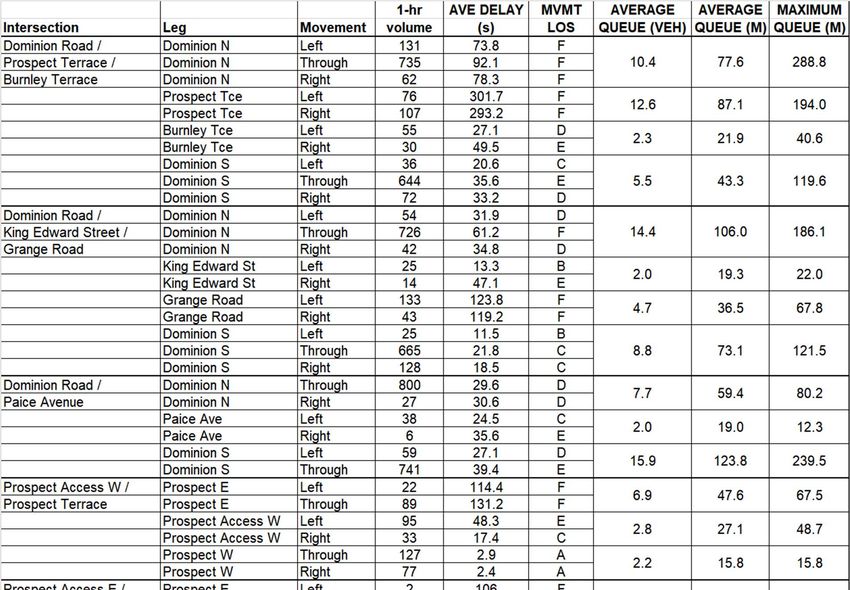
Executive Summary
The proposed development represents a significant contribution to achieving comprehensive mixed-use development in this
part of the Eden Valley, combining a supermarket, retail, commercial and residential activities on the one site. The proposal is
located on a major transport corridor, and within the Business – Mixed Use Zone which adjoins the Business – Local Centre
Zone that extends along both sides of Dominion Road to the north. All of this is surrounded by extensive residential
development that continues to increase as urban intensification continues in line with the wider transportation objectives and
policies of the Auckland region.
The location and nature of the proposal is therefore an appropriate one in terms of achieving an integrated land-use
development that can achieve efficiencies in the transport movements associated with the different activities on the site,
including the promotion of multi-purpose trips, pass-by trips, public transport usage, and walking and cycling.
One of the inevitable outcomes of any such intensification of mixed-use development will be the need to accept additional
traffic on the road network, particularly during the weekday afternoon peak periods and on weekends. This issue is one that
tends to go hand in hand with the Council’s objectives of urban intensification throughout many parts of Auckland, and in this
context increased peak period congestion cannot realistically be a reason for declining or slowing appropriate and anticipated
urban developments such as that currently proposed on the subject site. Rather, the continuing development and promotion
of alternative modes of transport, particularly for the work journey, will be assisted by the increasing journey times by private
vehicle during those peak periods.
To achieve such intensification of mixed-use development, a strong focus needs to be placed on alternative modes of travel,
other than the private vehicle, as is reflected in the various planning documents about Auckland. Consequently, this
development proposal has sought to recognise the importance of promoting public transport and walking/cycling as much as
possible, noting the following:
Key attributes of the subject site are its proximity and convenience to public transport services; to other
retail/commercial activities within Eden Valley; and to ongoing residential growth in the surrounding areas. This
provides the opportunities for minimising travel needs and promoting the use of alternative travel modes including
buses, walking and cycling.
The site forms an integral part of the retail/commercial/mixed-use activities in this part of Dominion Road, promoting
“shared trips” to visit multiple destinations, shared use of parking opportunities, walking between activities, etc, all
resulting in improvements to overall transportation efficiencies.
The mixed-use nature of the proposed development that includes residential, commercial, retail and a supermarket
activity will also assist in promoting internal trips within the site (e.g. providing the opportunity for living, working and
shopping on the same site). This promotes transport efficiency by reducing the number of vehicle trips.
The design of the development has sought to separate out pedestrian and vehicle access by placing the vehicle access
on the side roads and placing a strong focus on pedestrian activity in the vicinity of the pedestrian signals on the
Dominion Road frontage.
The proposal has also sought to maintain and enhance where possible the pedestrian amenity and safety around the
site by providing wider footpaths, suitable sight lines at vehicles access points and crossing facilities to promote
walking and safe behaviour.
The traffic modelling analysis undertaken as part of this assessment indicates that public transport efficiency will be
maintained at current levels, particularly during the evening PM peak period when demand for its use is at it highest.
The proposal is anticipated to align with Auckland Transport Vision Zero policies to reducing serious and fatal injury
crashes. Auckland Transport is currently addressing the high occurrence of motorcycle crashes at the intersections
and recently installed measures at these intersections will assist in ensuring these intersections can operate safety
and efficiently with the proposed development.
Ref: 16316-r2v11– Integrated Transport Assessment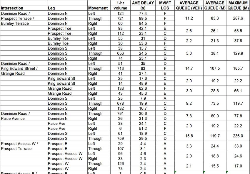
Traffic flows along Dominion Road are relatively high, particularly during the PM peak times and can be expected to increase
further as the desired intensive redevelopment continues along its corridor. However, the ongoing upgrading and promotion
of other modes of transport, particularly buses, will continue to have an effect on overall private vehicle usage, and in fact
ongoing congestion on the road network will if anything tend to have a positive effect on the desired switch to other modes of
transport.

The results of the traffic modelling undertaken as part of this ITA indicate that congestion and queuing on Dominion Road does
occur at present during peak periods (particularly in the southbound direction) and, as expected, this congestion will increase
as a result of the proposed development. The detailed modelling results are presented in the ITA, but the overall conclusion is
that, in the context of the already very busy transport environment of this part of Auckland, and to be able to accommodate
the type of comprehensive mixed-use development that is proposed, the predicted changes in journey times on Dominion Road
through this section of the road network during peak periods are acceptable. During most periods of the day, the increases in
queuing and delay will be much lower and Dominion Road will continue to operate efficiently.

The site has only two vehicle access opportunities, one on Prospect Terrace, and the other on Grange Road. Traffic flows on
both these roads will therefore increase, but the traffic modelling undertaken as part of this ITA indicates that the delays to
vehicles where these roads intersect with Dominion Road, taking into account the proposed mitigations, are not expected to
increase significantly, with vehicles continuing to rely on Dominion Road traffic to leave regular gaps consistent with the “keep
clear” markings installed to assist road safety. With no material increases in queues and delays, on the side roads, it is expected
that the safety of the side road intersections will be unchanged as drivers will not take any added risks to reduce delays.

The congestion that does occur on Dominion Road, including extensive queuing in the southbound direction during the weekday
PM peak and the northbound direction during the Saturday peak is primarily caused by congestion back from the existing signals
to the south and north of the site, respectively. Improvements to the operation of these intersections may be possible through
the better coordination and optimisation of their signal operation, but this is a matter that can only be determined by Auckland
Transport in the context of its aspirations for this road corridor. This may include enhancing the public transport network or
creating added facilities and amenity for pedestrians.

Whilst any increase in traffic on the local roads may be undesirable for many residents, the ever-increasing density of
development occurring and being promoted through the Unitary Plan means that the commercial activities on Dominion Road
that are there to serve the surrounding residential areas must be served by a complete road network that includes residential
roads and not just major arterial roads. Many of the customers visiting the proposed supermarket will be drawn from the
surrounding residential areas, and it is expected and acceptable for these customers to use the local residential roads to gain
access to the site. In fact, the planning controls that exist in relation to direct vehicle access along Dominion Road effectively
mean that all vehicle access is by necessity confined to the side roads.

The side roads with the highest increases in traffic flows are logically Prospect Terrace and Grange Road. Nevertheless, the
predicted increase in peak flows of about 65 vehicles per hour during the busiest times, are not considered to be excessive and
will not affect the general operation and safety of these roads. Both roads have the benefit of traffic calming devices with
raised tables and side islands at regular intervals to manage speeds. There are also mature trees at regular intervals and a high
occurrence of on-street parking that will also contribute to managing speeds.

The proposed development complies with all the traffic and parking design requirements and standards contained within
Section E27 of the Auckland Unitary Plan except for some minor infringements in relation to vehicle crossing widths and loading
bay provisions. Nevertheless, these infringements will not have an adverse effect on the surrounding transport environment.

It is concluded that, although there will be inevitable increases in congestion and delays on the road network during the peak
periods because of the proposed development, these are considered acceptable in the overall context of the nature of the
mixed-use development and the location of the site relative to alternative modes of transport. The proposed development is
therefore considered to be appropriate in overall transportation terms.

 Ref: 16316-r2v11– Integrated Transport Assessment
Silk Road Management Limited and Foodstuffs North Island Limited 1
Proposed residential, supermarket and retail/commercial development
360 Dominion Road, 88 Prospect Terrace and 113 Grange Road, Auckland
1. Introduction
The purpose of this report is to provide an Integrated Transport Assessment (ITA) of a proposal by Silk Road Management
Limited and Foodstuffs North Island Limited to establish a mixed-use development comprising residential apartments, a
supermarket, some smaller retail/commercial tenancies and some co-working office space on a site at 360 Dominion Road, 88
Prospect Terrace and 113 Grange Road, Eden Valley, Auckland. The property lies on the eastern side of Dominion Road between
the intersections with Prospect Terrace to the north and Grange Road to the south.
The proposed development is described in detail in the application, but essentially it involves the establishment of 122
residential apartments, a New World supermarket with a gross floor area (GFA) of 2787 m2, some small retail/commercial
tenancies totalling 575 m2 GFA, and 1257 m2 of co-working office space. The supermarket will be at ground level (Level 01) on
the southern part of the site and will have pedestrian access directly from Dominion Road. Car parking for the commercial
activities is to be provided beneath the supermarket on Level 00 across the whole site, with vehicle access from both Prospect
Terrace and Grange Road. A separate residential parking area is to be provided on Level 01 adjacent to the supermarket, and
will have access from Prospect Terrace. Servicing of the development will occur along the eastern boundary of the site, with
one-way vehicle operation from Prospect Terrace through to Grange Road.
The structure of this ITA is as follows:
Section 2 describes the site of the proposed development in the wider transport planning context, including a
discussion of the general accessibility of the site to various modes of transport.
Section 3 discusses the nature of the existing and future transport environments in the vicinity of the site, including
all modes of transport and matters relating to safety.
Section 4 describes the proposed development, including the site layout and access arrangements.
Section 5 discusses the travel characteristics of the proposed development and provides predictions of the expected
person trips and traffic flows associated with the development, including trip distribution on the surrounding road
network.
Section 6 describes the transport modelling that has been undertaken.
Section 7 assesses the effects of the development, including all transport modes, and matters relating to safety and
identifies the mitigation measures that are needed on the transport environment, including those relating to each
transport mode, and
Section 8 assesses the proposal in the context of the wider planning policies and strategies relating particularly to this
part of Auckland.
Section 9 assesses the proposal in terms of the relevant objectives, policies, rules, standards and assessment criteria
of the Auckland Unitary Plan (Operative in Part) (AUP).
Ref: 16316-r2v11– Integrated Transport Assessment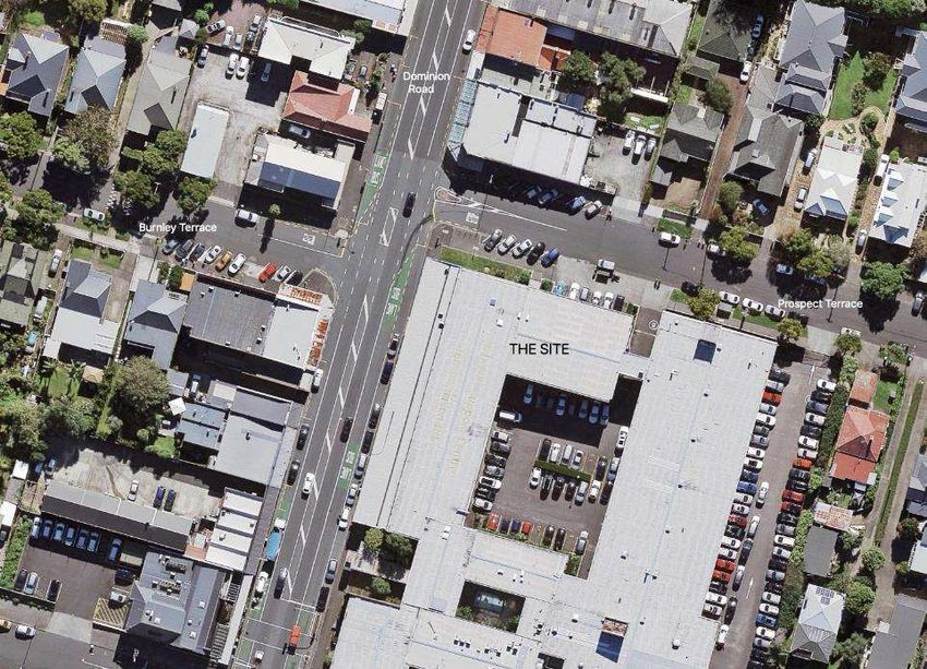
Silk Road Management Limited and Foodstuffs North Island Limited                                                            2
Proposed residential, supermarket and retail/commercial development
360 Dominion Road, 88 Prospect Terrace and 113 Grange Road, Auckland

2.          The transport planning context

2.1         Site location

The location of the site in relation to the surrounding road network is shown in Figure 1.

Figure 1: Site location

The site is located on the eastern side of Dominion Road, between Prospect Terrace to the north and Grange Road to the south.
Access to the site is currently provided through two vehicle crossings on Prospect Terrace and two vehicle crossings on Grange
Road, with no vehicle access on the Dominion Road frontage. Dominion Road is one of the main north-south arterial routes
through the Auckland Isthmus, linking New North Road at its northern end with Hillsborough Road at its southern end.

Figure 2 shows the site in the context of the AUP zoning. The site is at the northern end of the Business – Mixed Use Zone
which extends along both sides of Dominion Road to the south. It also adjoins the Business – Local Centre Zone that extends
along both sides of Dominion Road to the north.

 Ref: 16316-r2v11– Integrated Transport Assessment
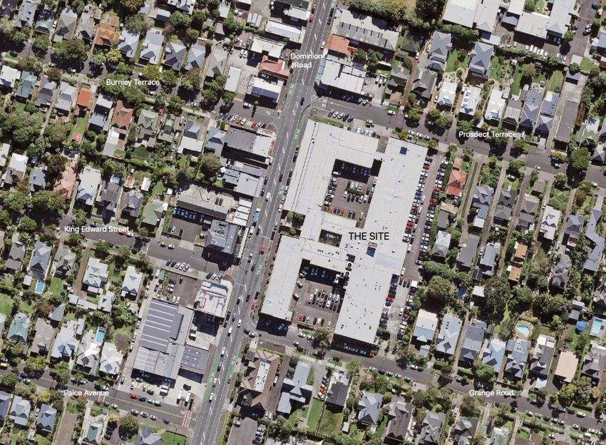
Silk Road Management Limited and Foodstuffs North Island Limited                                                                 3
Proposed residential, supermarket and retail/commercial development
360 Dominion Road, 88 Prospect Terrace and 113 Grange Road, Auckland

Figure 2: Site in the context of the Auckland Unitary Plan zoning

Figure 3 shows in more detail the site in relation to the immediately surrounding activities.

The site (Lot 2 DP170042) is currently occupied by a large commercial building that covers most of the site, with car parking in
the centre of the site and along the eastern boundary, accessed from both Prospect Terrace and Grange Road. The 14 retail
shops located along the majority of Dominion Road frontage are held in separate Body Corporate ownership and adjoin the
subject property. There are currently 218 parking spaces on the site including for the Lot 1 retail shops 31 accessory unit (AU)
carparks and 45 parking spaces located in Lot 1 common areas.

The properties along both sides of Dominion Road in the vicinity of the site contain small retail and commercial tenancies, and
the site backs onto those tenancies along the eastern side of Dominion Road between Prospect Terrace and Grange Road. The
properties to the east of the site are zoned Residential – Single House Zone, whilst to the south there is a mixture of Residential
- Terrace Housing and Apartment Buildings Zone and Residential – Mixed Housing Urban Zone.

 Ref: 16316-r2v11– Integrated Transport Assessment
Silk Road Management Limited and Foodstuffs North Island Limited                                                              4
Proposed residential, supermarket and retail/commercial development
360 Dominion Road, 88 Prospect Terrace and 113 Grange Road, Auckland

Figure 3: Site in relation to surrounding activities

2.2         General accessibility to travel modes

The current and future environments around the site in relation to the different travel modes are discussed in more detail later
in Section 3, but the general accessibility of the site to those modes of travel is summarised below.

2.2.1       The road network

Dominion Road is classed as an Arterial Road in the AUP, and as such forms an important part of the overall road network
serving the area. As seen in Figure 1, Dominion Road is one of the main north-south arterial corridors through the Auckland
Isthmus, linking New North Road at its northern end with Hillsborough Road at its southern end. It also links directly with the
South Western Motorway (State Highway 20) to the south, and with the main east-west arterial corridors of Balmoral Road and
Mt Albert Road.

Clearly the site has direct access to the primary road network, providing easy and convenient access for customers and residents
from all directions, including the extensive residential areas that surround the site in all directions.

 Ref: 16316-r2v11– Integrated Transport Assessment
Silk Road Management Limited and Foodstuffs North Island Limited                                                            5
Proposed residential, supermarket and retail/commercial development
360 Dominion Road, 88 Prospect Terrace and 113 Grange Road, Auckland

2.2.2       Public transport services

Current bus services within the vicinity of the site are shown in Figure 4.

Figure 4: Current bus services in the vicinity of the site

Dominion Road is a Frequent Service Route that forms part of Auckland Transport’s 2018 Rapid and Frequent Public Transport
Network.

The main bus services along Dominion Road are the 25B service (between the CBD and Blockhouse Bay) and the 25L service
(between the CBD and Lynfield). Both run every 10 minutes through most of the day on weekdays, and every 20 minutes at
weekends and on public holidays. These services are supplemented during the morning and afternoon peak periods by two
additional services, 252 and 253, linking the CBD with Blockhouse Bay or Lynfield.

The Outer Link service route also passes the site along the section of Dominion Road between Valley Road and Dominion Road,
and operates every 12-15 minutes between 6 am and midnight.

2.2.3       Walking

Figure 5 shows the 400m walking contour from the proposed main entrance to the site, whilst Figure 6 shows the 1km walking
contour. Being located adjacent to the Eden Valley Local Centre and within the retail and commercial activities that extend to
the south along Dominion Road, the site lies within a convenient walking distance of a considerable amount of residential
development on both sides of Dominion Road. The 1km contour also reaches down towards Balmoral Road to the south, Valley
Road to the north and Sandringham Road to the west.

 Ref: 16316-r2v11– Integrated Transport Assessment
Silk Road Management Limited and Foodstuffs North Island Limited       6
Proposed residential, supermarket and retail/commercial development
360 Dominion Road, 88 Prospect Terrace and 113 Grange Road, Auckland

Figure 5: 400m walking contour from the site

Figure 6: 1km walking contour from the site

 Ref: 16316-r2v11– Integrated Transport Assessment
Silk Road Management Limited and Foodstuffs North Island Limited                                                          7
Proposed residential, supermarket and retail/commercial development
360 Dominion Road, 88 Prospect Terrace and 113 Grange Road, Auckland

2.2.4      Cycling

Figure 7 shows the 3km cycling contour from the site, which encompasses a significant portion of the surrounding residential
areas, including Balmoral, Mt Eden, Morningside, Kingsland and Newton.

Figure 7: 3km cycling contour from the site

 Ref: 16316-r2v11– Integrated Transport Assessment
Silk Road Management Limited and Foodstuffs North Island Limited                                                               8
Proposed residential, supermarket and retail/commercial development
360 Dominion Road, 88 Prospect Terrace and 113 Grange Road, Auckland

3.         The transport environment

3.1        Existing road environment

The current road layout along Dominion Road and Prospect Terrace at the northern end of the site is shown in Figure 8.

Figure 8: Dominion Road and Prospect Terrace – existing layout

Dominion Road has two traffic lanes in each direction, with a painted flush median along the centre of the road and adjacent
to the subject property a width of approximately 22 metres. The two kerbside lanes operate as peak period bus lanes, with the
northbound bus lane operating in the 7-10 am period and the southbound bus lane operating in the 4-7 pm period. Kerbside
parking occurs during the off-peak periods, and there is additional recessed parking along parts of the eastern side of the road.

The current traffic environment along this section of Dominion Road is shown in Figures 9 and 10. As seen in these photos,
some changes have been made along this section of Dominion Road, including a build-out at the southbound bus stop and the
introduction of yellow hatched markings to keep areas clear at the intersections with Prospect Terrace and Burnley Terrace.

 Ref: 16316-r2v11– Integrated Transport Assessment
Silk Road Management Limited and Foodstuffs North Island Limited                                                                9
Proposed residential, supermarket and retail/commercial development
360 Dominion Road, 88 Prospect Terrace and 113 Grange Road, Auckland

Figure 9: Dominion Road looking to the north from Prospect Terrace

Figure 10: Dominion Road looking to the south from Prospect Terrace

Prospect Terrace is a two-lane road with kerbside parking along both sides. The western end of the road in the vicinity of the
site is commercial in nature and has angled car parking on both sides close to the Dominion Road intersection. The remainder
of Prospect Terrace to the east is residential in nature, and there is a residential "threshold" treatment located some 140 metres
to the east of Dominion Road.

The current traffic environment along the western section of Prospect Terrace is shown in Figures 11 and 12.

 Ref: 16316-r2v11– Integrated Transport Assessment
Silk Road Management Limited and Foodstuffs North Island Limited                                                               10
Proposed residential, supermarket and retail/commercial development
360 Dominion Road, 88 Prospect Terrace and 113 Grange Road, Auckland

Figure 11: Prospect Terrace looking to the east

Figure 12: Prospect Terrace looking to the west

Traffic on Prospect Terrace is controlled by a Stop sign and markings, and there is a pedestrian refuge island at the intersection.
The painted flush median on Dominion Road provides a haven for vehicles turning right into Prospect Terrace and assists
vehicles turning right onto Dominion Road. Vehicles reversing out of the existing angled parking (particularly that on the
northern side of the road) do create some conflict and delay to vehicles turning off Dominion Road into Prospect Terrace (see
Figure 11).

The current road layout along Dominion Road and Grange Road at the southern end of the site is shown in Figure 13, and the
current traffic environment in the vicinity of the intersection of Dominion Road and Grange Road is shown in Figures 14 to 17.

 Ref: 16316-r2v11– Integrated Transport Assessment
Silk Road Management Limited and Foodstuffs North Island Limited       11
Proposed residential, supermarket and retail/commercial development
360 Dominion Road, 88 Prospect Terrace and 113 Grange Road, Auckland

Figure 13: Dominion Road and Grange Road – existing layout

Figure 14: Dominion Road looking to the north from Grange Road

 Ref: 16316-r2v11– Integrated Transport Assessment
Silk Road Management Limited and Foodstuffs North Island Limited                                                         12
Proposed residential, supermarket and retail/commercial development
360 Dominion Road, 88 Prospect Terrace and 113 Grange Road, Auckland

Figure 15: Dominion Road looking to the south from Grange Road

The general layout of Dominion Road continues past Grange Road, with peak period bus lanes along both sides and a flush
median along the centre of the road. There is an existing signalised pedestrian crossing immediately to the north of the King
Edward Street intersection.

Traffic on Grange Road is controlled by a Stop sign and markings. The flush median along the centre of Dominion Road assists
traffic turning right to and from Grange Road, and yellow Keep Clear markings have been introduced to further assist these
movements.

Figure 16: Grange Road looking to the east

 Ref: 16316-r2v11– Integrated Transport Assessment
Silk Road Management Limited and Foodstuffs North Island Limited                                                           13
Proposed residential, supermarket and retail/commercial development
360 Dominion Road, 88 Prospect Terrace and 113 Grange Road, Auckland

Figure 17: Grange Road looking to the west

Grange Road is a two-lane road that is commercial in nature at its western end close to Dominion Road, and residential along
the remainder of its length to the east. There is a residential "threshold" treatment some 130 metres from the Dominion Road
intersection. There is angled parking on the northern side of the road close to Dominion Road, and vehicles reversing out of
those spaces can create conflict with vehicles turning into Grange Road.

3.2        Existing public transport environment

As noted earlier, Dominion Road is part of the Frequent Service Network, with bus services running every 10 minutes in both
the north and south directions, including the Outer Link service.

Peak period bus lanes operate along Dominion Road, during the 7-10 am period northbound and 4-7 pm period southbound.

A bus stop for southbound services is located immediately to the south of the Prospect Terrace intersection, and a kerb
extension has recently been provided, as seen in Figures 18 and 19.

For northbound services there is a bus stop located immediately to the north of the Burnley Terrace intersection, which is
located more or less directly opposite the Prospect Terrace intersection.

The existing pedestrian signals just north of King Edward Street provides a safe crossing point on Dominion Road but, given the
location of the northbound bus stop beyond the Burnley Terrace intersection, they do not provide a particularly convenient,
direct link between the two bus stops.

 Ref: 16316-r2v11– Integrated Transport Assessment
Silk Road Management Limited and Foodstuffs North Island Limited                  14
Proposed residential, supermarket and retail/commercial development
360 Dominion Road, 88 Prospect Terrace and 113 Grange Road, Auckland

Figure 18: Southbound bus stop, south of Prospect Terrace, looking to the north

Figure 19: Southbound bus stop looking to the south

 Ref: 16316-r2v11– Integrated Transport Assessment
Silk Road Management Limited and Foodstuffs North Island Limited                                                                15
Proposed residential, supermarket and retail/commercial development
360 Dominion Road, 88 Prospect Terrace and 113 Grange Road, Auckland

Figure 20: Northbound bus stop, north of Burnley Terrace

3.3        Existing pedestrian environment

3.3.1      Dominion Road

Figures 21 and 22 show the existing footpath along the eastern side of Dominion Road, past the site. There is a separated, two-
level footpath along the southern section (Figure 22), constructed as part of the current retail shops (Lot 1) and above first floor
commercial office accommodation contained within that portion of the existing building forming part of the title and ownership
of the subject property (Lot 2).

Figure 21: Existing footpath along eastern side of Dominion Road along the site frontage

 Ref: 16316-r2v11– Integrated Transport Assessment
Silk Road Management Limited and Foodstuffs North Island Limited                                                    16
Proposed residential, supermarket and retail/commercial development
360 Dominion Road, 88 Prospect Terrace and 113 Grange Road, Auckland

Figure 22: Existing footpath along eastern side of Dominion Road near the Grange Road intersection

Figure 23 shows the existing footpath on the eastern side of Dominion Road at the signalised pedestrian crossing.

Figure 23: Existing footpath at the pedestrian signals

3.3.2       Prospect Terrace

Figures 24 and 25 show the current pedestrian environment along the southern side of Prospect Terrace.

 Ref: 16316-r2v11– Integrated Transport Assessment
Silk Road Management Limited and Foodstuffs North Island Limited                                                            17
Proposed residential, supermarket and retail/commercial development
360 Dominion Road, 88 Prospect Terrace and 113 Grange Road, Auckland

Figure 24: Existing footpath along the southern side of Prospect Terrace

Figure 25: Existing footpath along the southern side of Prospect Terrace at existing vehicle exit

The current activities on the site are served by two vehicle crossings on Prospect Terrace, one of which is located immediately
adjacent to some angled parking that has been provided on the site, as seen in Figure 24. Vehicles manoeuvring to and from
these parking spaces have to cross the footpath which, coupled with the presence of the vehicle crossing, does not result in a
safe and attractive pedestrian environment.

The second vehicle crossing is an exit-only crossing towards the eastern end of the site (Figure 25). The boundary wall is built
right up to the boundary close to this exit, and intervisibility between exiting vehicles and passing pedestrians is poor.

 Ref: 16316-r2v11– Integrated Transport Assessment
Silk Road Management Limited and Foodstuffs North Island Limited                                                              18
Proposed residential, supermarket and retail/commercial development
360 Dominion Road, 88 Prospect Terrace and 113 Grange Road, Auckland

3.3.3      Grange Road

On the northern side of Grange Road, the footpath and grassed berm that extends over most of the site frontage is reduced to
a narrow footpath with overhanging vehicles that are using the angled parking close to Dominion Road (Figure 26). There is
also a vehicle entry crossing at this point.

Along this Grange Road frontage to the site there are three further existing vehicle crossings, one an exit-only crossing, and two
adjacent crossings at the eastern end of the site frontage (Figure 27).

Figure 26: Existing footpath along northern side of Grange Road

Figure 27: Existing vehicle crossings along northern side of Grange Road

 Ref: 16316-r2v11– Integrated Transport Assessment
Silk Road Management Limited and Foodstuffs North Island Limited                                                        19
Proposed residential, supermarket and retail/commercial development
360 Dominion Road, 88 Prospect Terrace and 113 Grange Road, Auckland

3.4        Existing cyclist environment

There are currently no dedicated cycle lanes along this section of Dominion Road, although cyclists can use the existing bus
lanes. Information provided by Auckland Transport indicates typical cyclist volumes recorded in November 2019 on Dominion
Road just north of Valley Road of 475 cyclists/day on weekdays and 160 cyclists/day at weekends.

The Auckland Cycle Network identifies parallel "Quiet Routes" that run through the residential streets along both sides of
Dominion, a small part of which uses Burnley Terrace and King Edward Street, linked by a short section of Dominion Road.
These "Quiet Routes" are marked as suitable for recreational cycling and for those commuter cyclists who prefer not to use
Dominion Road. These cycle routes are shown in Figure 28.

Figure 28: "Quiet" cycling routes either side of Dominion Road

3.5        Existing traffic flows

Traffic count data recorded by Auckland Transport on Dominion Road between Valley Road and Bellwood Avenue to the north
of the site in September 2018 is summarised in Table 1.

Table 1
Traffic flows on Dominion Road, between Valley Road and Bellwood Avenue
(source: Auckland Transport)
 Period                              September 2018 (two-way flows)

 5-day average (vpd)                             20,621
 7-day average (vpd)                             20,105
 Saturday (vpd)                                  20,456
 Sunday (vpd)                                    17,178
 AM peak hour (vph)                               1,362
 Midday hour (vph)                                1,453
 PM peak hour (vph)                               1,514

Similar traffic counts for Grange Road between Dominion Road and Henley Road in September 2018 are shown in Table 2.

 Ref: 16316-r2v11– Integrated Transport Assessment
Silk Road Management Limited and Foodstuffs North Island Limited                                                          20
Proposed residential, supermarket and retail/commercial development
360 Dominion Road, 88 Prospect Terrace and 113 Grange Road, Auckland

Table 2
Traffic flows on Grange Road between Dominion Road and Henley Road
(source: Auckland Transport)
 Period                             September 2018 (two-way flows)

 5-day average (vpd)                                 1,931
 7-day average (vpd)                                 1,851
 Saturday (vpd)                                      1,825
 Sunday (vpd)                                        1,476
 AM peak hour (vph)                                   204
 Midday hour (vph)                                    179
 PM peak hour (vph)                                   192

No counts are available on the Auckland Transport website for Prospect Terrace.

As part of this assessment, traffic surveys were undertaken in March 2020 at the following locations, and these are summarised
in Appendix A.

     o    Dominion Road/Prospect Terrace/Burnley Terrace intersection
     o    Dominion Road/King Edward Street intersection
     o    Dominion Road/Grange Road intersection
     o    Existing site accesses on Prospect Terrace and Grange Road

The surveys were conducted on Thursday 5 March 2020 during the 07:00-09:00 AM peak period and the 15:00-18:00 PM peak
period, and on Saturday 7 March 2020 during the 15:00-17:00 period.

Traffic surveys were repeated in November/December 2020 at the following locations, and these are summarised in
Appendix B:

     o    Dominion Road/Prospect Terrace/Burnley Terrace intersection
     o    Dominion Road/King Edward Street intersection
     o    Dominion Road/Grange Road intersection
     o    Dominion Road/Paice Avenue intersection

Based on the surveys undertaken on Thursday 26 November 2020 and Saturday 28 November 2020, the existing traffic flows
for the 1700-1800 peak period on Thursday and the 1200-1300 period on Saturday are shown in Figures 29 and 30 respectively.

 Ref: 16316-r2v11– Integrated Transport Assessment
Silk Road Management Limited and Foodstuffs North Island Limited 21
Proposed residential, supermarket and retail/commercial development
360 Dominion Road, 88 Prospect Terrace and 113 Grange Road, Auckland
Figure 29: Existing traffic flows - Thursday 1700-1800 Figure 30: Existing traffic flows - Saturday 1200-1300
3.6 Safety records
Appendix C presents a summary of the crash records maintained by the New Zealand Transport Agency for the period 2015-
2020 on the road network in the immediate vicinity of the site.
Figure 31 provides a summary of the reported crashes on the road network in the vicinity of the site for that period.
The key features of this crash record include the following:
At the Dominion Road/Prospect Terrace intersection, motorcyclists were involved in four of the five reported crashes
that involved vehicles turning right into Prospect Terrace. There was only one reported crash (non-injury) during that
period involving a vehicle turning right out of Prospect Terrace, and one accident involving a pedestrian crossing
Dominion Road.
At the Dominion Road/Burnley Terrace intersection, there were three reported crashes involving vehicles turning
right into Burnley Terrace, two of these involving motorcyclists.
At the Dominion Road/King Edward Street intersection there were four reported crashes. One involved a vehicle
turning right into King Edward Street being hit by a northbound motorcyclist, one involved a vehicle turning right into
Dominion Road, and two were nose-to-tail crashes one of which involved a cyclist hitting a bus.
Ref: 16316-r2v11– Integrated Transport AssessmentYou can also read