I-65 Bridges from I-264 to Kennedy Interchange Planning Study - Jefferson County, KY August 2019
←
→
Page content transcription
If your browser does not render page correctly, please read the page content below
I-65 Bridges from I-264 to Kennedy Interchange
Planning Study
Jefferson County, KY

August 2019

In Partnership With
Contents                                                                                        I-65 Bridges Study              August 2019

   Executive Summary
   Introduction .............................................................................................................. ES 1
   Purpose and Need ................................................................................................... ES 2
   Structure Condition .................................................................................................. ES 2
   Adjacent Projects ..................................................................................................... ES 3
   Environmental Overview .......................................................................................... ES 4
   User Impacts ............................................................................................................ ES 4
   Recommendations ................................................................................................... ES 4
   Priority Bridges......................................................................................................... ES 9
   Replacements .......................................................................................................... ES 9
   Prioritization ............................................................................................................. ES 9
   Schedule of Construction ......................................................................................... ES 9

   Report
   Introduction .................................................................................................................. 1
   Purpose and Need ....................................................................................................... 2
   Structure Condition ...................................................................................................... 2
   Adjacent Projects ......................................................................................................... 4
           Louisville Metro Two-Way Streets ...................................................................... 4
           Brook Street Off-Ramp ....................................................................................... 5
           I-65 Ramp Modification Scoping Study .............................................................. 5
   Environmental Overview .............................................................................................. 6
   User Impacts ................................................................................................................ 8
           Traffic Impacts Analyses .................................................................................... 8
           Data Used for Analyses ..................................................................................... 8
           Weekend Closures of I-65.................................................................................. 8
           Weekday Single-Lane Closures ....................................................................... 10
           Traffic Impact Summary ................................................................................... 11
           Project Area Parking Impacts......................................................................... 11
           Under-Bridge Parking....................................................................................... 11
           Communication Plan/Public Information Plan .................................................. 13
   Engineering Investigation........................................................................................... 13
   Findings ..................................................................................................................... 14
   Similar Projects .......................................................................................................... 15
   Estimates ................................................................................................................... 16
           Design ............................................................................................................ 16
           Right of Way................................................................................................... 16
           Utilities............................................................................................................ 16
           Construction ................................................................................................... 18

                                                                Page i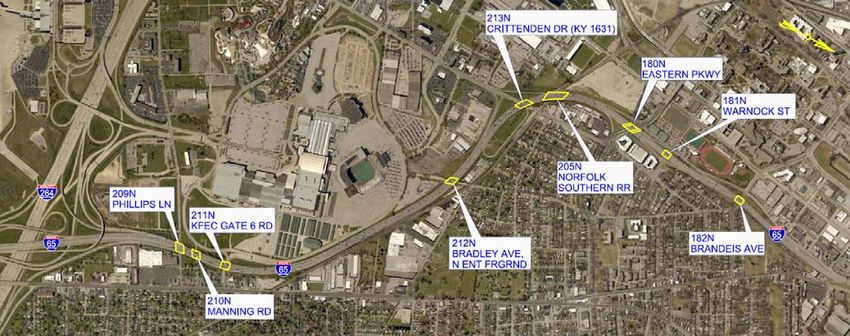
Contents                                                                                       I-65 Bridges Study              August 2019

   Recommendations ..................................................................................................... 20
            Repair Items/Techniques ................................................................................. 20
            Abutment Joint Elimination............................................................................... 20
            Slab Debonding Mitigation ............................................................................... 21
            Pier Joint Elimination........................................................................................ 22
            Media Joint Elimination .................................................................................... 25
            Other Repairs ................................................................................................... 25
   Advanced Repair Techniques ...................................................................................... 25
            Structural Steel Crack Repairs ......................................................................... 25
            Galvanic Cathodic Protection ........................................................................... 26
   Coordination................................................................................................................. 28
   Priority Bridges........................................................................................................... 28
            183N over Brook Street and Kentucky Street .................................................. 28
            179N over Burnett Avenue, Hill Street, and CSX RR ...................................... 33
            191N over Jacob Street, Broadway Street, and Gray Street ........................... 34
   Replacements ............................................................................................................ 34
   Prioritization of Work .................................................................................................. 38

   List of Tables
   Table 1: Bridge Ratings ............................................................................................... 2
   Table 2: Traffic Level of Service Analysis .................................................................... 9
   Table 3: I-65 Weekday Single-Lane Closure Queueing Analysis .............................. 10
   Table 4: Utility and Constraint Matrix ......................................................................... 17
   Table 5: Estimates ..................................................................................................... 18
   Table 6: VDOT Criteria for Abutment Joint Elimination.............................................. 20
   Table 7: Replacement Estimates for Bridges 179N and 183N .................................... 37
   Table 8: Repair Package 1 ........................................................................................ 39
   Table 9: Repair Package 2 ........................................................................................ 39
   Table 10: Repair Package 3 ...................................................................................... 40
   Table 11: Repair Package 4 ...................................................................................... 40

   List of Figures
   Figure 1: Study Bridges – I-264 to Brandeis Avenue ..................................................... 1
   Figure 2: Study Bridges – Burnett/Hill Street to Kennedy interchange ........................ 1
   Figure 3: Louisville Metro’s Planned Street Conversions ............................................ 4
   Figure 4: Brook Street Off-Ramp Project ..................................................................... 5
   Figure 5: Recommended Ramp Modifications from 2008 Planning Study .................. 6
   Figure 6: Debris from Homeless Encampments under Bridges ................................... 7

                                                               Page ii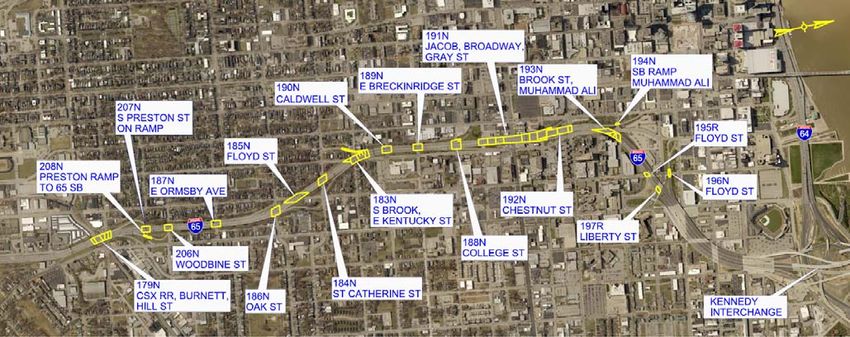
Contents                                                                                I-65 Bridges Study           August 2019

   Figure 7: Level of Service Description ......................................................................... 9
   Figure 8: Parking Lots under I-65 Bridges ................................................................. 12
   Figure 9a: Typical Abutment Joint Leakage and Concrete Damage ......................... 14
   Figure 9b: Typical Abutment Joint Leakage and Concrete Damage ......................... 15
   Figure 10: Expansion Joints Replaced in 2017 showing signs of distress
          in 2018 Inspections ........................................................................................ 15
   Figure 11: Abutment Joint Elimination by Slab Extension ......................................... 21
   Figure 12: Typical Slab Delamination at Bridge Ends ................................................ 22
   Figure 13: Typical Pier Joint Leakage and Concrete Damage .................................. 23
   Figure 14: Changes to Bridge Using a Link-Slab ....................................................... 24
   Figure 15: Typical Median Joint Leakage and Corrosion........................................... 25
   Figure 16: Conventional Patch Allows Corrosion to Continue ................................... 26
   Figure 17: Example Abutment Repaired Including Cathodic Protection .................... 27
   Figure 18: Substructure Repairs with Galvanic Anodes ............................................ 28
   Figure 19: Bridge 183N, I-65 over Brook Street and Kentucky Street ....................... 29
   Figure 20: Bridge 183N over Brook Street and Kentucky Street Framing Plan ......... 29
   Figure 21a: Framing Plan (continued) Showing Crack Locations .............................. 30
   Figure 21b: Framing Plan (continued) Showing Crack Locations .............................. 30
   Figure 22: Bridge 183N over Brook Street and Kentucky Street Crack History ......... 31
   Figure 23: Steel Girder Crack and Cover Plate Repair Option .................................. 32
   Figure 24: Post-Tensioned Integral Straddle Bent Option
          and Example from Kennedy Interchange ....................................................... 32
   Figure 25: I-65 over Burnett Avenue, Hill Street, and CSX Railroad ......................... 33
   Figure 26: Emergency Shoring to Bridge 179N ......................................................... 33
   Figure 27: Bridge 191N over Broadway Street showing Corroded Concrete Girder . 34
   Figure 28: Bridge 183N Replacement – Reuse of Existing Abutments Option .......... 35
   Figure 29: Bridge 183N Replacement – New Integral End Bents at South End ........ 35
   Figure 30: Bridge 179N - Prestressed Concrete Girder Replacement Option ........... 36
   Figure 31: Bridge 179N - New Integral End Bents at South End ............................... 37
   Figure 32: Repair Package Grouping - South ............................................................ 41
   Figure 33: Repair Package Grouping - North ............................................................ 41

   Appendices
   Appendix A:       Environmental Overview
   Appendix B:       Highway Capacity Software Output (HCS7)
   Appendix C:       Under-Bridge Parking Agreements
   Appendix D:       Sample Communication Plan
   Appendix E:       Bridge Element Condition State Quantities
   Appendix F:       Summary of Repair Quantities
   Appendix G:       Similar Projects

                                                          Page iii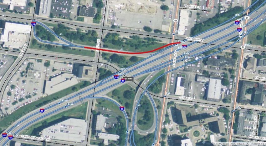
Contents                                                 I-65 Bridges Study   August 2019

   Appendix H: Sample Special Notes
   Appendix I: Utilities and Constraints
   Appendix J: Individual Bridge Repair Cost Estimates
   Appendix K: Cathodic Protection Articles
   Appendix L: Minutes from Project Team Meetings
   Appendix M: Bridge 183N and 179N Replacement Cost

                                       Page iv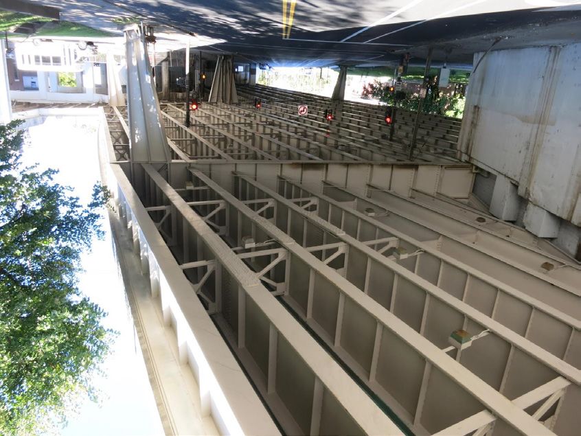
Executive Summary                                                     I-65 Bridges Study   August 2019

Introduction
The Kentucky Transportation Cabinet (KYTC) initiated a study of the I-65 Bridges in Jefferson County
in June 2018. This study’s objective is to assess conditions and prioritize and develop conceptual
strategies for repair or replacement of all bridges along Interstate 65 between the Watterson
Expressway (I-264) and the rebuilt Kennedy Interchange in Louisville, KY, 28 bridges in all (Figures
ES1 and ES2).

                                   Figure ES1: Study Bridges – South

                                   Figure ES2: Study Bridges – North

Three bridges were identified as priorities for KYTC: 179N over CSX RR, Burnett Avenue, and Hill
Street; 183N over Brook Street and Kentucky Street; and 191N over Jacob Street, Broadway Street
and Gray Street. Replacement scenarios have also been developed for bridges 183N and 179N due to
their poor condition. In addition to the structural focus, this study includes an environmental overview

                                               Page ES 1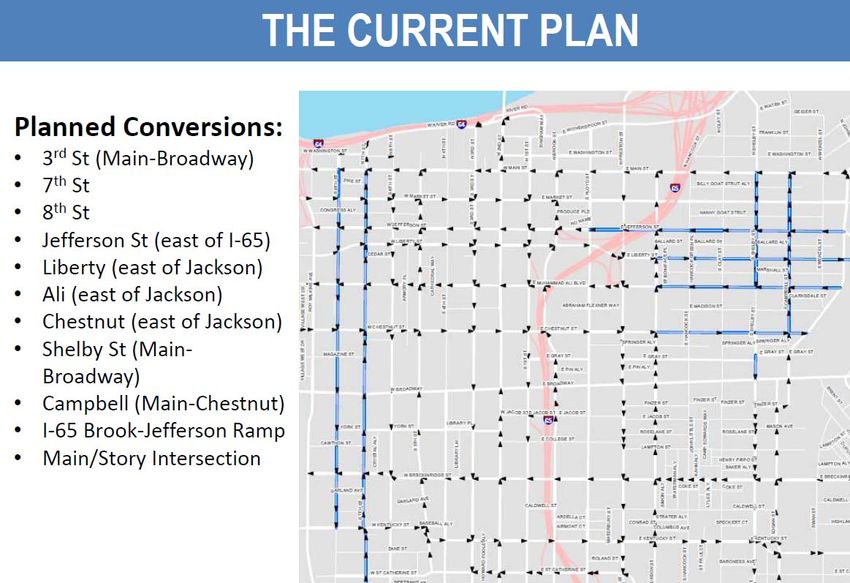
Executive Summary                                                    I-65 Bridges Study       August 2019

with attention to socioeconomic impacts, review of adjacent projects for synergistic construction
possibilities, preliminary traffic impact analyses, and a framework communication plan for construction
activities.

Purpose and Need
The purpose of this study is to evaluate, identify and develop strategies to address deficiencies in 28
bridges on Interstate 65 between the Watterson Expressway (I-264) and the rebuilt Kennedy
Interchange in Louisville.

As part of KYTC’s asset management program, these strategies are needed to maintain safe and
efficient travel through the I-65 corridor.

Structure Condition
Bridge inspections show declining conditions over time for most of the bridges in the study area. See
(Table ES1) below for existing conditions.
                                      Table ES1: Bridge Ratings
                                                                    NBI Ratings
                                               Sufficiency                                     Bridge
    Bridge ID    Route Under                                          Super-        Sub-
                                                 Rating      Deck                             Condition
                                                                     structure    structure
      209N      PHILLIPS LN                       75.9        5         5            5          Fair
      210N      MANNING RD                         73         5         5            5          Fair
      211N      E ENT TO FAIRGROUNDS              81.4        5         5            5          Fair
      212N      BRADLEY AVE, N ENT FRGRND          82         5         5            5          Fair
      213N      CRITTENDEN DR (KY 1631)            94         6         6            6          Fair
      205N      NORFOLK SOUTHERN RR                72         5         5            5          Fair
      180N      EASTERN PKWY                       84         5         6            5          Fair
      181N      WARNOCK ST                         82         5         6            5          Fair
      182N      BRANDEIS AVE                      74.7        5         5            5          Fair
      179N      CSX RR, BURNETT, HILL ST           49         5         4            3          Poor
      208N      PRESTON RAMP TO 65 SB              66         5         5            6          Fair
      207N      S PRESTON ST ON RAMP               80         5         6            6          Fair
      206N      WOODBINE ST                        70         6         6            5          Fair
      187N      E ORMSBY AVE                      80.2        5         6            6          Fair
      186N      OAK ST                             69         5         6            5          Fair
      185N      FLOYD ST                          81.6        5         6            6          Fair
      184N      ST CATHERINE ST                    82         5         7            5          Fair
      183N      S BROOK, E KENTUCKY ST            46.7        5         4            4          Poor
      190N      CALDWELL ST                       86.8        6         6            6          Fair
      189N      E BRECKINRIDGE ST                 67.2        6         5            6          Fair

                                               Page ES 2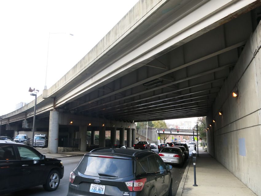
Executive Summary                                                      I-65 Bridges Study     August 2019

                                Table ES1: Bridge Ratings (continued)
                                                                      NBI Ratings
                                                 Sufficiency                                   Bridge
    Bridge ID    Route Under                                           Super-     Sub-
                                                   Rating      Deck                           Condition
                                                                      structure structure
      188N      COLLEGE ST                          80.1        6         6           6         Fair
      191N      JACOB, BROADWAY, GRAY ST            73.9        6         5           5         Fair
      192N      CHESTNUT ST                         77.1        6         5           5         Fair
      193N      BROOK ST, MUHAMMAD ALI               76         5         5           5         Fair
      194N      MUHAMMAD ALI                         96         7         7           6         Fair
      196N      FLOYD ST                            75.7        5         6           5         Fair
      195R      FLOYD ST                            96.9        7         7           6         Fair
      197R      LIBERTY ST                           96         5         6           6         Fair

       Notes to Table 1:
       Sufficiency rating is a numerical value (0 for the worst and 100 for the best) that gives an
       indication of a bridge’s eligibility for rehabilitation or replacement and is based on structural
       adequacy, safety, serviceability, function obsolescence, and essentiality for public use.
       National Bridge Inventory (NBI) condition rating (0 for worst and 9 for best) reports the condition
       of a bridge component as an evaluation of its current physical state compared to what it was on
       the day it was built.
       Good = Bridge has all three NBI condition ratings for deck, super and sub of 7 or higher.
       Poor = Bridge has at least one NBI condition rating for deck, super or sub of 4 or lower.
       Fair    = all other bridges.

Adjacent Projects
Louisville Metro Two-Way Streets
Louisville Metro has initiated a plan for the conversion of select one-way streets to two-way circulation.
The only street under I-65 planned for conversion at this time is Jefferson Street, outside of our project
limits. Louisville’s Public Works Department should be contacted for possible coordination during
construction if city streets have planned utility or paving work in the study area.

Brook Street Off-Ramp
Bridge 196N over Floyd Street is an off-ramp being studied for realignment. This project is in the design
phase and could be ready for construction as early as 2021. Because alternates being considered
would replace bridge 196N, it is recommended that any proposed repairs in this area be delayed until
the disposition of a new bridge is known.

I-65 Ramp Modifications Scoping Study
This 2008 study included alternatives to improve traffic flow, safety, and access associated with the I-
65 ramps from Crittenden Drive to St. Catherine Street. No recommendations have been implemented,
and no particular advantage would be gained from concurrent I-65 bridge repairs if portions of the ramp
improvements are implemented.

                                                Page ES 3
Executive Summary                                                       I-65 Bridges Study    August 2019

Environmental Overview
Any proposed bridge repair projects in the study area will have minimal environmental impacts because
all construction will occur within existing right of way. No impacts to historic properties, archaeological
sites, ecological resources, etc. are anticipated. Socioeconomic impacts may occur due to temporary
disruptions during construction to commuters, local residences, businesses, and the homeless
population who seek shelter beneath several of the area bridges.

With the availability of detour routes, the impacts to commuters and businesses are expected to be
minimal. However, the homeless populations that reside under several of the bridges will be temporarily
displaced by construction activities. After coordination with Louisville Metro and homeless advocacy
groups, policies and procedures successfully implemented during similar projects will be utilized for this
work.

User Impacts
Traffic Impacts Analyses
Traffic operational analyses were completed for both single-lane closures during the weekday and total
closure by direction for weekend-only construction activities. These analyses indicated a reduction in
Level of Service from LOS C/D to LOS E/F during weekday closures and weekend closures. Also,
queueing analysis showed that during afternoon peak hours (4:00-6:00 pm), additional traffic backup of
7,000-8,600 feet could be anticipated for the single-lane weekday closure scenario. The queue analysis
shows that the existing four-lane and three-lane sections have no queueing; however, the three-lane
segments with a single-lane closure begin to generate a 7,000-8,600 feet queue during the peak hours
(4:00-6:00 pm).

Under-Bridge Parking
Under-bridge parking exists at several locations within the study area via permits. Permit holders have
been identified and when those areas are scheduled for repair, coordination should begin early so that
alternate accommodations can be secured prior to construction.

Communication Plan
Successful Public Information Plans / Communication Plans for similar Louisville interstate projects
were reviewed, and a conceptual plan for both weekday and weekend road or lane closures, as well as
parking displacement, is included in Appendix D.

Recommendations
Abutment Joint Elimination
The vast majority of bridges in this study have active corrosion within the concrete at their abutments
and concrete girder ends, if comprised of concrete girders. This is the location of expansion joints, and
it is evident that many joints have failed and are leaking (Figure ES3). Abutment joint elimination via
deck slab extension is recommended wherever possible (Figure ES4).

                                                 Page ES 4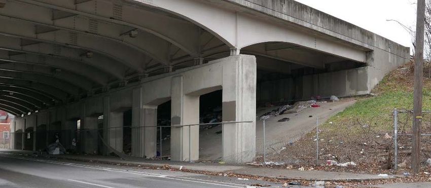
Executive Summary                                         I-65 Bridges Study   August 2019

       Figure ES3: Typical Abutment Joint Leakage and Concrete Damage

           Figure ES 4: Abutment Joint Elimination by Slab Extension

                                   Page ES 5
Executive Summary I-65 Bridges Study August 2019
Traffic operational analyses show that the effect/impact of the single-lane closure with traffic shift is
comparable to complete direction closures with weekend-only work. The continuous single-lane closure
to traffic is the recommended maintenance of traffic scheme to allow time for abutment joint elimination
of half a bridge width, by direction, at a time.
Pier Joint Elimination
Similarly, expansion joints at piers have identical leakage and corrosion problems and can be eliminated
in some instances (Figure ES5). Pier joint elimination by implementing link-slabs and reconfiguring
bearings for longitudinal movement and load resistance is recommended wherever possible (Figure
ES6a and ES6b).
Figure ES5: Typical Pier Joint Leakage and Concrete Damage
Pier with Link-Slab Labels
Figure ES6a: Changes to Bridge Using a Link Slab
Page ES 6Executive Summary I-65 Bridges Study August 2019
Pier Configuration with Joint Pier Configuration with Link-Slab
Figure ES6b: Changes to Bridge Using a Link Slab (New York Department of Transportation
Presentation)
Additional Improvements
Several instances of slab debonding at bridge ends were observed. (Figure ES7) It is recommended
to add shear studs to the top flange of the steel beams when abutment joints are eliminated. Likewise,
corrosion was observed at several joints between bridge barriers at the median (Figure ES8).
Elimination of this median joint is also recommended by replacing the two barriers with a single barrier,
similar to the north end of the study area.
Page ES 7Executive Summary I-65 Bridges Study August 2019
Figure ES7: Typical Slab Delamination at Bridge Ends
Figure ES8: Typical Median Joint Leakage and Corrosion
Baseline repair cost estimates include conventional repair techniques to known deficiencies,
improvements listed above, and special repairs for isolated structural steel cracks and damage caused
by vehicles. Special post-tensioned, integral straddle bents are repair options for Bridge 183N (Brook
and Kentucky Streets); Bridge 191N (the Broadway Bridge) has options to use Fiber Reinforced
Polymer (FRP) fabric for girder repairs or replacement with a new prestressed concrete girder line.
Extended Durability - Galvanic Cathodic Protection
It is recommended that traditional repairs be augmented with cathodic protection where leaky joints
have infused concrete areas with chlorides. Basic cathodic systems distribute zinc rods or pucks
uniformly throughout the repair zones, and at minimum, a 30-year corrosion-free repair can be achieved
for only an additional 6% to the construction cost.
Page ES 8Executive Summary I-65 Bridges Study August 2019
Priority Bridges
183N over Brook Street and Kentucky Street: Multiple options are provided to repair this bridge
including repair of structural steel cracking by coverplating and by encasement into a post-tensioned
(PT), integral straddle pier. Replacement options are also postulated with PT straddle bents where
needed. Existing abutments are large counterfort vertical abutments; so replacement options identified
recommend to leave most, or all of the existing abutments in place, and to span over them to establish
new integral end bents.
179N over Burnett Avenue, Hill Street, and CSX RR: This bridge recently had emergency shoring
due to disintegration of some of the south abutment’s concrete-bearing areas. A concrete repair option
is provided in the estimate as well as a superstructure-only replacement and a complete replacement.
191N over Jacob Street, Broadway Street, and Gray Street: This long bridge consists of seven
different structural units, with a reinforced concrete unit over Broadway Street having a severely
deteriorated girder. It can be repaired in place with a fiber reinforced polymer (FRP) fabric bonded to
the repaired surface or by removing the damaged girder line and replacing the girder line with a new
prestressed concrete girder and slab area.
Replacements
Bridge 183N over Brook and Kentucky Streets cost is $17.2 - $18.5 million to replace. Although
approximately three times the cost of repairs, replacement would be a prudent investment for this 60
plus year-old bridge with fracture critical members and many undesirable fatigue prone details.
Bridge 179N over Burnett Avenue, Hill Street, and CSX railroad, cost is $5.7 million for superstructure
replacement and $8.1 million for full bridge replacement. With the repair options approaching $3.8
million, replacement should be seriously considered.
Prioritization
All 28 bridges were ranked as High, Moderate, or Low priority based on condition. The three priority
bridges, identified above, are the only ones ranked High, eight ranked as Moderate and 17 ranked Low
priority. Bridge 196N was ranked moderate but it may be replaced as a part of an existing project; the
project team recommends delaying action on it. The remaining seven moderately deteriorated bridges
are clustered in two areas, namely at the north and south ends of the study area.
Schedule of Construction
Repair/replacement of 179N, 183N, and 191N should be first to be constructed, followed by all eight
bridges rated moderate priority, then the 17 low-priority group would be completed. So construction
crews are not hop-scotching around the corridor for years on end, it is recommended to geographically
group the eight moderate-priority bridges with additional lower-priority bridges (Figures ES9 and
ES10). Specific group size depends on available funding, exact scope of work, and tolerance for
construction duration. Suggested contract packages with estimated construction costs are:
Page ES 9Executive Summary I-65 Bridges Study August 2019
High Priority:
Repair Package No. 1: 179N, 183N and 191N Estimated Cost = $14,460,000
Moderate Priority: College Street to Liberty Street
Repair Package No. 2: 188N, 192N, 193N, 194N, 195R, 197R Estimated Cost = $7,650,000
Moderate Priority: Phillips Lane to Brandeis Avenue
Repair Package No. 3: 209N, 210N, 211N, 212N, 213N, 205N, 180N, 181N, 182N
Estimated Cost = $11,200,000
Low Priority: Preston Street Ramps to Breckinridge Street
Repair Package No. 4: 208N, 207N, 206N, 187N, 186N, 185N, 184N, 190N, 189N
Estimated Cost = $8,850,000
Legend
Repair Package No. 1
Repair Package No. 2
Repair Package No. 3
Repair Package No. 4
Figure ES9: Repair Package Grouping – South
Legend
Repair Package No. 1
Repair Package No. 2
Repair Package No. 3
Repair Package No. 4
Figure ES10: Repair Package Grouping – North
Page ES 10I-65 Bridges Study August 2019
Introduction
The Kentucky Transportation Cabinet (KYTC) initiated a study of the I-65 Bridges in Jefferson County
in June 2018. This study examines the conditions, prioritizes, and develops conceptual strategies to
address deficiencies of 28 Interstate 65 bridges between the Watterson Expressway (I-264) and the
rebuilt Kennedy Interchange in Louisville, Kentucky (Figures 1 and 2). This corridor carries an annual
average daily traffic (AADT) of nearly 120,000 vehicles. The area of bridge deck encompassed within
these structures is over 717,000 square feet, or about 16.5 acres.
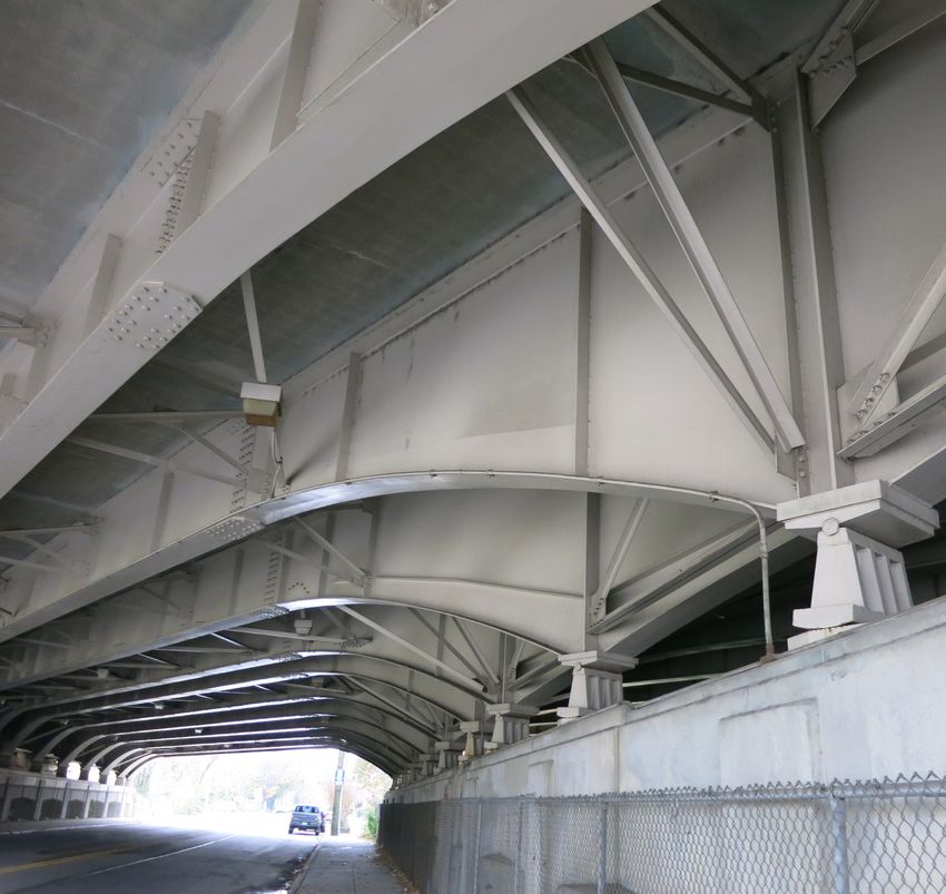
Figure 1: Study Bridges – I-264 to Brandeis Avenue
Figure 2: Study Bridges – Burnett/Hill Street to Kennedy Interchange
Three bridges were identified as priorities for KYTC: 179N over CSX RR, Burnett Avenue, and Hill
Street; 183N over Brook Street and Kentucky Street; and 191N over Jacob Street, Broadway Street,
and Gray Street. Replacement scenarios have also been developed for bridges 183N and 179N due to
Page 1 of 41I-65 Bridges Study August 2019
their poor condition. In addition to the structural focus, this study includes an environmental overview
with attention to socioeconomic impacts, review of adjacent projects for synergistic construction
possibilities, preliminary traffic impact analyses, and a framework communication plan for construction
activities.
According to KYTC’s 2018 Transportation Asset Management Plan (TAMP), most decisions regarding
maintenance, repair, and rehabilitation are made by districts based on engineering judgment,
knowledge of the inventory, and experience with recurring issues. KYTC’s Central Office makes the
decisions to replace bridges. This decision is based on district recommendations and the Sufficiency
Rating (SR) of the bridge. To use federal funds for bridge replacements, the SR must be 50.0 or less
(See Table 1)
The TAMP report recommends: maintenance of bridges in Fair and Good condition, rehabilitation of
bridges in Fair condition, and major rehabilitation or replacements of bridges in Poor condition. Two
study bridges are rated Poor, and 26 are rated Fair.
Purpose and Need
The purpose of this study is to evaluate, identify and develop strategies to address deficiencies in 28
bridges on Interstate 65 between the Watterson Expressway (I-264) and the rebuilt Kennedy
Interchange in Louisville.
As part of KYTC’s asset management program, these strategies are needed to maintain safe and
efficient travel through the I-65 corridor.
Structure Condition
Bridge inspections show declining conditions over time for most of the bridges in the study area. See
(Table 1) below for existing conditions.
Table 1: Bridge Ratings
NBI Ratings
Sufficiency Bridge
Bridge ID Route Under Super- Sub-
Rating Deck Condition
structure structure
209N PHILLIPS LN 75.9 5 5 5 Fair
210N MANNING RD 73 5 5 5 Fair
211N E ENT TO FAIRGROUNDS 81.4 5 5 5 Fair
212N BRADLEY AVE, N ENT FRGRND 82 5 5 5 Fair
213N CRITTENDEN DR (KY 1631) 94 6 6 6 Fair
205N NORFOLK SOUTHERN RR 72 5 5 5 Fair
180N EASTERN PKWY 84 5 6 5 Fair
181N WARNOCK ST 82 5 6 5 Fair
182N BRANDEIS AVE 74.7 5 5 5 Fair
Page 2 of 41I-65 Bridges Study August 2019
Table 1: Bridge Ratings (continued)
NBI Ratings
Sufficiency Bridge
Bridge ID Route Under Super- Sub-
Rating Deck Condition
structure structure
179N CSX RR, BURNETT, HILL ST 49 5 4 3 Poor
208N PRESTON RAMP TO 65 SB 66 5 5 6 Fair
207N S PRESTON ST ON RAMP 80 5 6 6 Fair
206N WOODBINE ST 70 6 6 5 Fair
187N E ORMSBY AVE 80.2 5 6 6 Fair
186N OAK ST 69 5 6 5 Fair
185N FLOYD ST 81.6 5 6 6 Fair
184N ST CATHERINE ST 82 5 7 5 Fair
183N S BROOK, E KENTUCKY ST 46.7 5 4 4 Poor
190N CALDWELL ST 86.8 6 6 6 Fair
189N E BRECKINRIDGE ST 67.2 6 5 6 Fair
188N COLLEGE ST 80.1 6 6 6 Fair
191N JACOB, BROADWAY, GRAY ST 73.9 6 5 5 Fair
192N CHESTNUT ST 77.1 6 5 5 Fair
193N BROOK ST, MUHAMMAD ALI 76 5 5 5 Fair
194N MUHAMMAD ALI 96 7 7 6 Fair
196N FLOYD ST 75.7 5 6 5 Fair
195R FLOYD ST 96.9 7 7 6 Fair
197R LIBERTY ST 96 5 6 6 Fair
Notes to Table 1:
Sufficiency rating is a numerical value (0 for the worst and 100 for the best) that gives an
indication of a bridge’s eligibility for rehabilitation or replacement and is based on structural
adequacy, safety, serviceability, function obsolescence, and essentiality for public use.
National Bridge Inventory (NBI) condition rating (0 for worst and 9 for best) reports the condition
of a bridge component as an evaluation of its current physical state compared to what it was on
the day it was built.
Good = Bridge has all three NBI condition ratings for deck, super and sub of 7 or higher.
Poor = Bridge has at least one NBI condition rating for deck, super or sub of 4 or lower.
Fair = all other bridges.
Page 3 of 41I-65 Bridges Study August 2019
Adjacent Projects
Louisville Metro Two-Way Streets
Louisville Metro has initiated a plan (Figure 3) for the
conversion of select one-way streets to two-way
circulation, where appropriate, to improve mobility and
safety. Recent contact with Louisville Metro confirmed
that the only street under I-65 planned for conversion at
this time is Jefferson Street, scheduled for Fall 2019.
Additional streets are under consideration for conversion
in the future. As bridge repairs are scheduled,
Louisville’s Public Works Department should be
contacted for possible coordination during construction if
utility or paving work is scheduled for any city streets in
the study area.
CAMPBELL ST
SHELBY ST
North limits of I-65
Bridges study E JEFFERSON ST
(Liberty Street) E LIBERTY ST
E MUHAMMAD ALI BLVD
E CHESTNUT ST
8TH ST
7TH ST
Figure 3: Louisville Metro’s Planned Street Conversions (Louisville Metro)
Page 4 of 41I-65 Bridges Study August 2019
Brook Street Off-Ramp (KYTC Item No. 5-378.10)
Bridge 196N over Floyd Street lies within the existing I-65 southbound off-ramp, under consideration
for realignment (Figure 4). Louisville Metro’s engineering consultant for the project was contacted for
a status update. In both alternatives under evaluation, the Floyd Street Bridge would be replaced. A No-
Build Alternative is also possible.
BRIDGE 196N
Figure 4: Brook Street Off-Ramp Project
The project is in preliminary engineering and environmental analysis
and has not yet had public outreach. Final design may not begin
until at least late 2019. With certain utility and possibly some right-
of-way (relocations) impacts, it could be let for construction in 2021
or 2022.
I-65 Ramp Modifications Scoping Study
A 2008 study recommended to improve traffic flow, safety, and
access associated with ramps along I-65 from Crittenden Drive to St.
Catherine Street. The improvements were estimated to be $60-70
million in 2005 dollars (Figure 5) and none of these improvements
have been implemented. In KYTC’s Strategic Highway Investment
For Tomorrow (SHIFT) rankings for 2017 North Region Projects 1, the 0F
recommendations from the 2008 study were ranked 123rd with a cost
to complete of $100,400,000.
1
In 2016, Gov. Matt Bevin directed the Kentucky Transportation Cabinet (KYTC) to develop a process to better allocate
the Commonwealth's limited transportation funds. The Strategic Highway Investment Formula for Tomorrow (SHIFT) was
the result -- a data-driven, objective approach to compare capital improvement projects and prioritize transportation
spending. SHIFT helps reduce over programming and provides a clear road map for construction in the coming years. The
formula applies to all transportation funding that isn't prioritized by other means, such as maintenance work, local
government projects and dedicated federal projects. The North Region encompasses KYTC Districts 5, 6, and 7. (KYTC)
Page 5 of 41I-65 Bridges Study August 2019
Some of the priority phases could be constructed concurrently with the repairs of nearby bridges, in this
study, but no advantage is gained from combining them with the I-65 bridge work. Most of the ramp
modification work would be adjacent to I-65 whereas the bridge work is on I-65.
I-65 RAMP MODIFICATIONS (2008)
PRELIMINARY ESTIMATES OF PROBABLE COSTS
Figure 5: Recommended I-65 Ramp Modifications from 2008 Planning Study (2005 Dollars) (KYTC)
Environmental Overview
The bridge repair projects will have minimal environmental impacts because all construction will occur
within existing right of way. There will be no effects to historic properties, archaeological sites, ecological
resources, etc. Socioeconomic impacts may occur due to temporary disruptions during construction to
commuters, local residences, businesses, and the homeless population who seek shelter beneath
several of the area bridges.
With the availability of detour routes (I-264 and I-265) around Louisville, the impacts to commuters and
businesses is expected to be minimal. However, the homeless populations that reside under several of
the bridges will be temporarily displaced by construction activities. Several site visits were made and
homeless populations were observed at one or more of the priority bridges. In addition, individuals were
observed at five other bridge locations scattered throughout the corridor (Figure 6). The number of
Page 6 of 41I-65 Bridges Study August 2019
homeless people under those structures varied. Visits were made during the morning daylight hours
and it is expected that those numbers likely increase during the evening hours. The number of people
observed at various locations ranged from several to more than 20 with most having set up
encampments.
Figure 6: Debris from Homeless Encampments under Bridges
During assessment of this issue, local leaders and advocate groups such as the Coalition for the
Homeless and Wayside Christian Mission were engaged to understand how to minimize adverse
impacts to the homeless during construction activities. Louisville Metro expressed a strong preference
and willingness to lead these efforts since they have procedures in-place to implement under similar
circumstances. This involves providing a 21-day advance notice of construction activities, administered
by Louisville Metro and networking with advocate groups to provide assistance to this population.
Page 7 of 41I-65 Bridges Study August 2019
Outreach volunteers coordinated through Louisville Metro’s Office of Resiliency was effective.
Volunteers identify recent homeless persons and communicate options and services available. An effort
was made to follow those in camps so that opportunities for available shelter or housing are conveyed.
Louisville Metro strongly encouraged, from the outreach agencies, to utilize established communication
channels to maximize effectiveness and for the safety of all involved. Experience on prior projects where
homeless were displaced has yielded success stories and lessons learned.
It was noted that the homeless populations do not consistently use the same bridges as shelter from
year-to-year and are more transient during the summer months. Typically, as winter approaches, the
homeless become encamped at a particular location and remain there until spring. If displaced during
cold weather months, materials gathered under bridges such as blankets, tents, or other forms of shelter
could be left behind and quickly scavenged. Metro’s experience has shown that timing construction to
occur during warmer weather can minimize impacts to the homeless. The full Environmental Overview
is found in Appendix A.
User Impacts
Traffic Impacts Analyses
Two different scenarios for maintaining traffic while constructing bridge repair / improvement scenarios
were considered. The scenarios studied were:
Full Closures during the weekend along I-65 between I-264 to the south and I-64 to the north
o Closures begin on Friday evenings at about 9:00 pm and extend throughout the weekend
with required opening of I-65 by 5:00 am on Monday morning.
o Closures could involve either a single direction or both directions on I-65.
Single-Lane Closures during weekdays
o Scenario involves part-width construction of proposed repair / improvement concepts on
a lane-by-lane basis.
Data Used for Analyses
Traffic count data for I-65 between I-264 and I-64 were obtained from the Kentucky Transportation
Cabinet for August 2017 and August 2018. Hourly volume counts were analyzed for a two-week period
between August 12-25, 2018. Short-term hourly counts were analyzed for the week of August 8 – 15,
2017. This helped to identify the AM and PM peak traffic volumes and the distribution of traffic for
weekdays versus weekends. The greatest weekend peak hourly traffic volume for this segment of I-65
was 3,175 vehicles per hour. For weekday traffic, the greatest peak hourly traffic volume was 4,379
vehicles per hour. These weekend and weekday peak hourly volumes aided to evaluate worst-case
analyses for each maintenance of traffic scenario. A worst-case analysis of traffic operations on I-65
determined significant advantages or disadvantages with either of the possible scenarios for
maintaining traffic during construction.
Weekend Closures of I-65
Weekend closures of I-65 will require diversions of all traffic from I-65 to other routes. For example,
closure of I-65 Northbound at the interchange with I-264 will require diverting all traffic from I-65 to either
I-264 or the surface street network. An efficient or practical means of estimating the traffic diverted to
surface streets was not within the scope of this study. Therefore, to approximate worst-case conditions,
Page 8 of 41I-65 Bridges Study August 2019
it was assumed when I-65 is closed at the I-264 Interchange, half of the traffic would use I-264
eastbound, and half of the traffic would use I-264 westbound. Thus, 1,587 vehicles per hour were added
to the peak hour traffic on I-264 in each direction.
The augmented peak hour traffic
volumes were then used for a Level
of Service (LOS) analysis. Level of
Service is a qualitative performance
measure used to evaluate a
roadway or intersection congestion.
Levels of service are described
according to a letter rating system
ranging from LOS “A” (free flow,
minimal or no delays – best
condition) to LOS “F” (severe
congestion, long delays – worst
conditions) (Figure 7). LOS C or
better is desirable in rural areas
while LOS D or better is desirable in
urban areas. Highway Capacity
Software (HCS) was employed to
determine the change in LOS for I-
264 when traffic from I-65 is
diverted onto it. From these
analyses, the LOS on I-264 is
worsened by at least a letter when
I-65 is closed on weekends (Table Figure 7: Level of Service Description
2). A similar analysis was
completed for I-64 when southbound I-65 is closed during the weekend and diverted onto I-64. See
Appendix B for HCS data.
Table 2: Traffic Level of Service Analysis
Existing Conditions Closure Conditions
Route Time *Adjusted/
Adjusted Average Average
Volume Density LOS Volume Workzone Density LOS
Capacity Speed Speed
Capacity
veh / hr pc / hr / ln mph pc / mi / ln veh / hr pc / hr / ln mph pc / mi / ln
I‐64 east of I‐65 Weekend 2084 2141 51.2 23.7 C 3671 2141/‐ 47.7 44.7 E
I‐64 west of I‐65 Weekend 2368 2133 50.4 18.2 C 3955 2133/‐ 50.4 30.4 D
I‐264 east of I‐65 Weekend 4333 2132 50.2 25.1 C 5920 2132/‐ 50.2 34.3 D
I‐264 west of I‐65 Weekend 3048 2138 50.9 23.2 C 4635 2138/‐ 50.9 35.3 E
I‐65 w/ three
Weekday 4379 2204 50.4 33.7 D 4379 2204/2294 ‐ ‐ F
Lanes
I‐65 w/ four Lanes Weekday 4379 2204 50.4 25.3 C 4379 2204/2349 47.9 35.4 E
*Adjusted work zone capacity is calculated using the same equation as capacity with an additional work zone
adjustment factor.
Page 9 of 41I-65 Bridges Study August 2019
Weekday Single-Lane Closures
Segments of I-65 in this area involve both three and four lanes in each direction. Using the Work Zone
configuration in HCS, it was determined that reducing the number of lanes from three to two lanes
during construction for bridge work would worsen traffic flow from LOS D to LOS F. Similarly, reducing
the number of available lanes from four to three lanes during construction, worsens traffic flow from
LOS C to LOS E, as shown in Table 2.
A companion analysis using HCS was completed to estimate the queue length traffic backups
associated with single-lane closures. It was determined from these analyses that backups would occur
between 4:00 pm and 6:00 pm if the three lane portions of I-65 were reduced to two for construction
(Table 3). Queue lengths are estimated to be 234 vehicles per hour (approximately 7,000 feet) between
4:00 pm and 5:00 pm. Queue lengths increase to 287 vehicles per hour (8,600 feet) between 5:00 pm
and 6:00 pm. Based on the work zone queueing analysis, the queue lengths increase to 287 vehicles
per hour (8,600 feet) between 5:00 pm and 6:00 pm during the single lane closure in the three-lane
segment of I-65. The analysis revealed there to be no existing queue during the same peak hour time.
Table 3: I-65 Weekday Single-Lane Closure Queueing Analysis
*Average Four to three Three to two
Time Estimated
Reduced lanes lanes
Beginning Volume
Volume Queue (Veh) Queue (Veh)
0:00 726 726 0 0
1:00 436 436 0 0
2:00 362 362 0 0
3:00 362 362 0 0
4:00 652 652 0 0
5:00 1668 1334 0 0
6:00 3772 3018 0 0
7:00 5440 4352 0 0
8:00 4642 3714 0 0
9:00 3626 2901 0 0
10:00 3408 2726 0 0
11:00 3554 2843 0 0
12:00 3772 3018 0 0
13:00 3916 3133 0 0
14:00 4424 3539 0 0
15:00 5222 4178 0 0
16:00 5802 4642 0 234
17:00 5802 4642 0 287
18:00 4280 3424 0 0
19:00 3046 2437 0 0
20:00 2466 1973 0 0
21:00 2248 1798 0 0
22:00 1668 1334 0 0
23:00 1160 928 0 0
Total Queue 0 521
*When the Estimated Volume exceeds 1,000 vehicles, it was assumed that 20% of vehicles would take alternate
routes to avoid congestion in the construction zone. The vehicles that do not divert and enter construction is
considered the Average Reduced Volume
Page 10 of 41I-65 Bridges Study August 2019
Traffic Impact Summary
These analyses show that either scenario for maintaining traffic during construction will result in a
reduced Level of Service (quality of traffic flow) during construction of up to two LOS letters, with several
directions having an undesirable LOS E/F. It also was determined that single-lane weekday closures
on I-65 could result in backups during afternoon peak hours (4:00 pm to 6:00 pm) up to 8,600 feet.
Depending on the exact bundle of bridges to repair, an additional maintenance of traffic scenario might
be appropriate to consider. If the geographic location is favorable, a traffic crossover could be beneficial.
This scenario would entail splitting a direction of travel so that one lane is left of the median barrier and
one lane is right of the median barrier. This option should be explored further once bridge groupings
are finalized.
Project Area Parking Impacts
Under-Bridge Parking
Site visits to the various bridges in the study area indicated parking lots with a number of spaces exist
under the following bridges:
Bridge 183N – South Brook, and East Kentucky Streets
Bridge 191N – Jacob, Broadway, and Gray Streets
Bridge 192N – Chestnut Street
Bridge 193N – Brook Street and Muhammad Ali
Additionally, metered street parking is present under the following bridges:
Bridge 191N – Jacob, Broadway, and Gray Streets
Bridge 192N – Chestnut Street
Bridge 193N – Brook Street and Muhammad Ali
Bridge 196N – Floyd Street
Bridge 195R – Floyd Street
Permitting for parking under interstate bridges such as those noted above typically is handled through
Encroachment--Air Space Use Agreements or Permits. Parking at these locations has been in place
for several decades. Thus, no electronic copies of the permit documents were located. Transportation
Cabinet records were researched with the assistance of Permitting Staff in both District 5 and Central
Office. A manual search of permit files indicated the following files may be applicable to parking under
bridges:
Brook and Gray Street – August 28, 1978 Encroachment Agreement (Updated November 4,
2005) – James Graham Brown Foundation with Commonwealth of Kentucky
o Adjacent to I-65 – Purposes of maintaining an elevator shaft, air conditioner, parking lot,
and retaining wall and waterline – parking lot encroaches 5.3 feet by 2.1 feet.
Jacob Street to Broadway, Broadway to Gray Street, Gray Street to Chestnut Street – Air Space
Agreement – May 6, 1965 – Jewish Hospital Association and Commonwealth of Kentucky --
Parking for an indefinite term until revoked
o Broadway to Chestnut Street – November 29, 1961 – Air Space Agreement for Parking
– City of Louisville and Commonwealth of Kentucky
City of Louisville allocated the parking areas from Broadway to Gray Street to
University of Louisville
Page 11 of 41I-65 Bridges Study August 2019
City of Louisville allocated parking areas from Gray Street to Chestnut Street to
Jewish Hospital
Preston and Jefferson Street – Air Space Agreement – September 17, 1984 – University of
Louisville and Commonwealth of Kentucky – Parking beneath I-65
Broadway and Jacob Street – Air Space Agreement – University of Kentucky, Jefferson
Community College, and Commonwealth of Kentucky – December 7, 1989 – Expanded existing
parking areas under I-65 between Broadway and Jacob Streets.
Scanned copies of the above documents can be found in Appendix C. This information is provided for
reference only and describes all information pertaining to airspace agreements under I-65 for this area
that could be easily found within KYTC files. Both District 5 and Central Office Permits Branch staff
have undergone changes since these airspace agreements were executed, and both offices have
moved to new facilities. Therefore, it is possible that not all existing documents were found during
research.
As repair and improvements to bridges are initiated, the information described above may be a useful
starting point in developing a plan for managing any affected parking areas. Most parking areas also
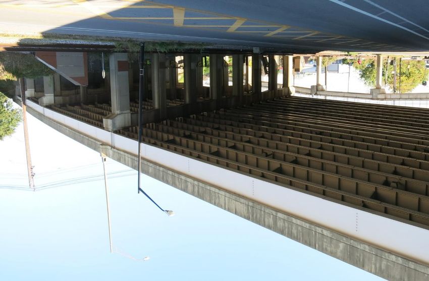
have signage indicating the administrator for that specific parking area (Figure 8).
Figure 8: Parking Lots under I-65 Bridges
Page 12 of 41I-65 Bridges Study August 2019
Thus, administrators of parking areas affected by construction should be contacted early to coordinate
necessary parking limitations during construction. Many of these air space agreements include the
phrase “for an indefinite time until revoked without charge or rental.” Early agreements also may have
permitted the air space lease holder to make improvements such as paving, lighting, and fencing that,
if damaged, may need to be repaired / replaced during construction. Specifics of liability and
responsibility should be determined and enumerated for the lease holders and contractors prior to
beginning construction. Also, early coordination with parking permit holders will allow alternate parking
to be found for users of the facilities.
Communication Plan/Public Information Plan
The primary goal of the Communication Plan or Public Information Plan (PIP) is to inform the motoring
public and area stakeholders of project information including planned Maintenance of Traffic (MOT)
activities including significant lane and ramp closures. The KYTC District 5 Public Information Officer
(PIO) will coordinate and disseminate to stakeholders and the media appropriate information regarding
the construction plans.
A conceptual Communication Plan / PIP is intended to serve as a framework for developing a specific
plan for each bridge repair / improvement project tailored to the specific schedule, scope of work, and
maintenance of traffic plan for addressing that bridge or group of bridges.
The PIP includes the following:
Local Stakeholders
Local Agencies potentially affected by the project (Emergency responders: Police; Fire; EMS)
Utility Companies
A method of outreach to trucking firms and out-of-state stakeholders
Special events and venues that could affect or be affected by the project
Project Schedule and Description of Work
Proposed Media Relations
Coordination with out-of-state Departments of Transportation and Traffic Centers
Appendix D is a conceptual Communication Plan / Public Information Plan intended as a starting point
to develop individual plans once bridge groupings and MOT plans are known.
Engineering Investigation
For this study, each bridge was visited with the most current bridge inspection report and plans in hand.
Site visits allowed for confirmation of major bridge deficiencies as well as information gathering that
could affect a contractor’s means and methods of bridge repair. All bridge site visits occurred prior to
the first project team meeting held December 13, 2018.
KYTC’s Bridge Management program (BrM) was accessed to obtained original bridge plans, bridge
widening plans, repair histories, bridge inspection reports, and photo logs of previous bridge
inspections. Additionally, the bridge element-level condition state data 2 was downloaded for all bridges
1F
2
Element-level bridge inspection consists of defining the elements (individual part of the bridge) and total quantities of
each element on the bridge. The total quantity of defects for each element is recorded based on their severity (1 for the best
and 4 for the worst) to show the condition of each element.
Page 13 of 41I-65 Bridges Study August 2019
for use in repair cost estimating (Appendices E and F). The wealth of data contained in BrM was
extremely useful to assess declining bridge conditions over time and the success / failure of previous
bridge repairs.
In particular, it was determined that bridge expansion joints are a major weakness of these high-traffic
bridges. Records show that expansion joints have been repaired several times over roughly the past
decade, on all study bridges, but they continue to deteriorate rapidly once these repairs are in service.
Not only are the expansion joints themselves failing rapidly, but leakage of brackish water from deicing
salts through the joints during winter months wreak havoc on reinforced concrete structures below.
Chlorides penetrate the saturated concrete and migrate toward reinforcing steel. Over time, the steel
corrodes and causes cracking and spalling of the surrounding concrete. One major recommendation of
this report is to investigate innovative ways to eliminate this widespread problem and preserve the
significant infrastructure value these bridges represent.
Findings
Most bridges within this study area were constructed as part of Louisville’s North-South Expressway in
the late 1950’s. Since then, most have been widened and, on / off ramps have been added. Some
superstructure replacements have occurred. A significant portion of the study bridges are original and,
being 60 years old, have specific areas of distress. One of the most detrimental deficiencies to the
longevity of the bridges is joint leakage, as mentioned in the previous section (Engineering
Investigation). Several bridges have obvious joint leakage at abutments and resulting damage to the
reinforced concrete abutments (Figures 9a and 9b).
Figure 9a: Typical Abutment Joint Leakage and Concrete Damage
Page 14 of 41I-65 Bridges Study August 2019
Figure 9b: Typical Abutment Joint Leakage and Concrete Damage
Bridge expansion joints show distress or failure at many locations. Even joints recently replaced in 2017
showed signs of premature failure and leakage onto the substructures below (Figure 10).
Figure 10: Expansion Joints Replaced in 2017 showing signs of distress in 2018 Inspections
Similar Projects
In July 2008, KYTC repaired four bridges on I-265 (two over Westport Road and two over a ramp to
Westport Road). This project entailed several repair methods recommended for the bridges in this study.
Appendix G contains the plans showing similar repairs: pier joint eliminations with link-slabs; bearing
replacements; end-of-bridge uplift mitigation; structural steel repairs; pier cap restoration, etc. Also
included are the bids for that project with average bids calculated and unit costs escalated to 2019
Page 15 of 41I-65 Bridges Study August 2019
dollars. This prior project is analogous to the study area bridges as both are within Jefferson County;
include bridges on an interstate highway; include similar bridge repairs with a similar maintenance of
traffic plan to one of the options presented for this study: to work on half a bridge-width at a time.
A second, more recent project was also analyzed for similarities. The project involved bridge deck
restoration and waterproofing of five bridges on and/or intersecting I-65 and I-264 and was let to
construction in March 2019. This project is just south of the limits of this study and also entails repairs
to interstate bridges. Some of the types of repairs are similar, but not as extensive as recommended for
the 28 bridges in this study. One significant item that was found to be useful was that the maintenance
of traffic costs were more current and should better reflect current requirements than the other similar
project. Data from this project is also included in Appendix G.
Estimates
Traditional KYTC project estimates are broken into four distinct phases: design (D), right of way (R),
utilities (U), and construction (C). Although mostly focused on the construction phase, all phases are
included to indicate which bridges will require added design, right of way and / or utility time, and cost.
It is recommended that all other phases be completed prior to construction if at all possible. If
advantageous and acceptable to all parties, utility relocations could become a portion of the construction
contract as long as impediments to the contractor’s control of construction are eliminated.
Design
Many repair details can be developed using the KYTC Standard Specifications for Road and Bridge
Construction, standardized details, and special notes (see Appendix H for sample special notes) in a
Contract Ready Proposal (CRP) format. Other repairs will require structural analysis, design, and
unique details. In either case, it will be necessary to prepare a maintenance of traffic plan and
associated PIP, general notes, repair location schematics, etc. Design estimates herein are based on
historical projects covering both CRP preparation and bridge-specific repair designs. Duration estimates
assume negotiation time for a consultant to be engaged to prepare the required repair plans. If KYTC
utilizes in-house forces for this effort, the duration could be shorter.
Right of Way
All of the work to repair the 28 study bridges can be accomplished within existing KYTC right of way.
However, a few bridges host under-bridge parking. In these situations, time and cost estimates are
included for coordination with leaseholders. Additionally, time and cost estimates are included in the
right-of-way phase for coordination with Norfolk and Southern Railroad, CSX Railroad, Kentucky Fair
and Exposition Center, University of Louisville, and Louisville Metro for impacts and restrictions to city
streets and rail crossings.
Utilities
Many of the bridges have one or more utilities attached, under, or near the structure. If a utility is directly
attached at or near a repair site, it would have to be (temporarily or permanently) relocated. For utilities
adjacent to a bridge, contractor access could be limited or restricted. Therefore, advance planning and
coordination with utility owners will be required. This portion of estimates typically has more variability
and risk due to utility companies’ policies regarding prequalification for design, relocation services, and
scheduling. Bridges eligible for abutment joint elimination with conduit attached to the abutment are
Page 16 of 41You can also read