BOTTINEAU LRT / METRO BLUE LINE EXTENSION BICYCLE STUDY - Final Draft February 2016
←
→
Page content transcription
If your browser does not render page correctly, please read the page content below
BOTTINEAU LRT / METRO BLUE LINE
EXTENSION BICYCLE STUDY
Final Draft

                          February 2016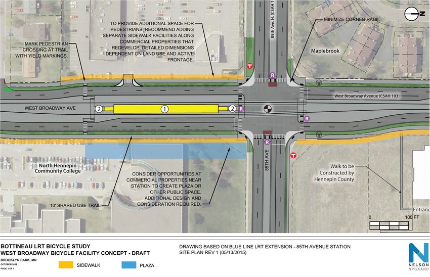
BOTTINEAU LRT / METRO BLUE LINE EXTENSION BICYCLE STUDY
                                                                  Hennepin County

Table of Contents
                                                                                                                                                          Page
1   Introduction......................................................................................................................1-1
    Purpose of this Study ............................................................................................................................ 1-1
    Vision Statement..................................................................................................................................... 1-1
    Strategies ................................................................................................................................................ 1-2
    Study Area .............................................................................................................................................. 1-3
2   Bicycle Network ...............................................................................................................2-1
    Bikeshed Methodology ......................................................................................................................... 2-1
    Types of Bicycle Facilities..................................................................................................................... 2-3
    Existing and Proposed Bicycle Network ............................................................................................ 2-5
    Key Location: Olson Memorial Highway ....................................................................................... 2-17
    Key Location: West Broadway ........................................................................................................ 2-21
    Key Location: Golden Valley Station Bicycle Access................................................................... 2-23
    Strategies for Bicycle Paths in High-Activity Pedestrian Areas .................................................. 2-25
    Funding Opportunities......................................................................................................................... 2-28
3   Low Stress Route..............................................................................................................3-1
    Proposed Low Stress Route .................................................................................................................. 3-2
    Prototypical Crossing Treatments ....................................................................................................... 3-7
    Wayfinding........................................................................................................................................... 3-11
4   Bicycle Facilities At Stations.............................................................................................4-1
    General Bicycle Parking Recommendations ..................................................................................... 4-1
    Bike Parking Demand Estimate ........................................................................................................... 4-6
    Bike Parking Recommendations ........................................................................................................ 4-10
    Additional Opportunities to Increase Bicycle Ridership ............................................................... 4-13
5   Bicycle Network Project Prioritization ..............................................................................5-1
    Identifying Projects for Prioritization ................................................................................................. 5-1
    Prioritization Criteria ............................................................................................................................ 5-1
    Prioritized Projects by Municipality ................................................................................................... 5-2
6   Appendix .........................................................................................................................6-1
    Appendix A: Oak Grove Station Area Proposed Road Network.............................................. 6-2
    Appendix B: North Minneapolis Greenway Route Alternatives.................................................. 6-3
    Appendix C: Complete Bicycle Network Project Prioritization ................................................... 6-4
    Appendix D: Southwest LRT – Literature Review of BikeShare Program Models ................... 6-5

Table of Figures
                                                                                                                                                          Page
Figure 1           Bottineau LRT Corridor......................................................................................................... 1-3
Figure 2           Values of Variables and Coefficients Used in Bikeshed Analysis ............................... 2-2
Figure 3           Examples of Access and Egress Bikesheds....................................................................... 2-3
Figure 4           Types of Bicycle Facilities.................................................................................................... 2-4
Figure 5           Existing Bicycle Network...................................................................................................... 2-5
Figure 6           Proposed Bicycle Network .................................................................................................. 2-6

                                              Nelson\Nygaard Consulting Associates Inc. | ii
BOTTINEAU LRT / METRO BLUE LINE EXTENSION BICYCLE STUDY
                                                           Hennepin County

Figure 7     Existing Bicycle Network – Oak Grove Bikeshed........................................................... 2-7
Figure 8     Proposed Bicycle Network – Oak Grove Bikeshed ....................................................... 2-8
Figure 9     Existing Bicycle Network – 93rd Ave, 85th Ave, Brooklyn Blvd Bikesheds ................. 2-9
Figure 10    Proposed Bicycle Network – 93rd Ave, 85th Ave, Brooklyn Blvd Bikesheds............ 2-10
Figure 11    Existing Bicycle Network – 63rd Ave, Bass Lake Rd Bikesheds .................................. 2-11
Figure 12    Proposed Bicycle Network – 63rd Ave, Bass Lake Rd Bikesheds .............................. 2-12
Figure 13    Existing Bicycle Network – Robbinsdale Bikeshed ....................................................... 2-13
Figure 15    Existing Bicycle Network – Golden Valley Rd, Plymouth Ave, Penn Ave, Van
             White Blvd Bikesheds......................................................................................................... 2-15
Figure 16    Proposed Bicycle Network – Golden Valley Rd, Plymouth Ave, Penn Ave, Van
             White Blvd Bikesheds......................................................................................................... 2-16
Figure 17    Proposed Configuration of Olson Memorial Highway (North Side) at Penn
             Avenue .................................................................................................................................. 2-18
Figure 18    Plan View Sketch of Olson Memorial Highway (North Side) at Penn Avenue ....... 2-19
Figure 19    Proposed Configuration of Olson Memorial Highway (North Side) at James
             Avenue .................................................................................................................................. 2-20
Figure 20    Plan View Sketch of Olson Memorial Highway (North Side) at James Avenue .... 2-20
Figure 21    Proposed Olson Memorial Highway Bicycle Route across the I-94 Bridge for
             Opening Day ....................................................................................................................... 2-21
Figure 22    Proposed Olson Memorial Highway Bicycle Route across I-94 Bridge with Future
             Bridge Reconstruction ......................................................................................................... 2-21
Figure 23    West Broadway Bicycle Facility Concept ...................................................................... 2-22
Figure 24    Golden Valley Road Station Bicycle Access ................................................................. 2-24
Figure 25    Bicycle Path Passing Behind Transit Stop ....................................................................... 2-25
Figure 26    Wider Bicycle Path at Transit Stop ................................................................................. 2-25
Figure 27    Two-way cycle track with raised crossing behind a bus stop (Seattle, WA).......... 2-26
Figure 28    Raised crosswalk across bike path with motion-activated flashing lights (New
             York, NY) .............................................................................................................................. 2-26
Figure 29    Cycle track and bus stop (Warsaw, Poland) ................................................................ 2-27
Figure 30    Potential Funding Opportunities ...................................................................................... 2-28
Figure 31    Proposed Low Stress Route ................................................................................................. 3-2
Figure 32    Low Stress Route Map (Oak Grove, 93rd Ave, 85th Ave, Brooklyn Blvd) .................. 3-3
Figure 33    Low Stress Route Map (Brooklyn Blvd, 63rd Ave, Bass Lake Rd) ................................. 3-4
Figure 34    Low Stress Route Map (Brooklyn Blvd, 63rd Ave, Bass Lake Rd) ................................. 3-5
Figure 35    Low Stress Route Map (Robbinsdale, Golden Valley Rd, Plymouth Ave, Penn
             Ave, Van White Blvd) .......................................................................................................... 3-6
Figure 36    Confirmation Sign in Indianapolis, IN ............................................................................. 3-11
Figure 37    Turn Sign in Savannah, GA ............................................................................................... 3-11
Figure 38    Decision Sign in Colombus, OH ........................................................................................ 3-11
Figure 39    Standard U-Rack (Recommended) .................................................................................... 4-2
Figure 40    Wave Rack (Not Recommended) ...................................................................................... 4-2
Figure 41    Large Bike Parking Shelter ................................................................................................. 4-3
Figure 42    Trimet Bike & Ride in Parking Structure ........................................................................... 4-4
Figure 43    Secure Bike Room in Private Development ...................................................................... 4-4
Figure 44    Free-standing Bike Cage .................................................................................................... 4-4
Figure 45    Beaverton, OR Transit Center Bike & Ride ...................................................................... 4-4

                                       Nelson\Nygaard Consulting Associates Inc. | iii
BOTTINEAU LRT / METRO BLUE LINE EXTENSION BICYCLE STUDY
                                                           Hennepin County

Figure 46    Bike Repair Station............................................................................................................... 4-5
Figure 47    Bike Parts Vending Machine ............................................................................................... 4-5
Figure 48    Bike Corral in Parking Ramp .............................................................................................. 4-5
Figure 49    Total 2040 LRT Boardings by Segment and Station ..................................................... 4-6
Figure 50    Bicycle Mode Share Estimates by Segment..................................................................... 4-7
Figure 51    Estimated Bike Parking Needs by Segment .................................................................... 4-8
Figure 52    Bikeshed Population Ratios with Overlapping Bikesheds ............................................. 4-9
Figure 53    Bike Parking Demand by Station Bikesheds .................................................................... 4-9
Figure 54    Estimated Space Requirements for Short-term Bike Parking ..................................... 4-10
Figure 55    Velodome Guardian Double Bike Shelter ..................................................................... 4-11
Figure 56    Recommended Bike Parking Type and Space Requirements .................................... 4-11
Figure 57    Bike Parking Type and Space Requirements for Medium Demand Estimate ......... 4-12
Figure 58    Bike Parking Type and Space Requirements for Low Demand Estimate................. 4-12
Figure 59    Recommended Bike Parking Type and Space Requirements for High Demand
             Estimate ................................................................................................................................. 4-13
Figure 60    Prioritization Criteria ........................................................................................................... 5-2
Figure 61    Champlin Project Priority Map ........................................................................................... 5-3
Figure 62    Champlin Project Prioritization Score ............................................................................... 5-4
Figure 63    Brooklyn Park Project Priority Map (North) .................................................................... 5-5
Figure 64    Brooklyn Park Project Priority Map (South) ..................................................................... 5-6
Figure 65    Brooklyn Park Project Prioritization Score ....................................................................... 5-7
Figure 66    Brooklyn Center Project Priority Map............................................................................... 5-8
Figure 67    Brooklyn Center Project Prioritization Score ................................................................... 5-9
Figure 68    Maple Grove Project Priority Map ................................................................................. 5-10
Figure 69    Maple Grove Project Prioritization Score ..................................................................... 5-11
Figure 70    New Hope Project Priority Map ...................................................................................... 5-12
Figure 71    New Hope Project Prioritization Score ........................................................................... 5-13
Figure 72    Osseo Project Priority Map .............................................................................................. 5-14
Figure 73    Osseo Project Prioritization Score ................................................................................... 5-15
Figure 74    Robbinsdale Project Priority Map ................................................................................... 5-16
Figure 75    Robbinsdale Project Prioritization Score ........................................................................ 5-17
Figure 76    Plymouth Project Priority Map ......................................................................................... 5-18
Figure 77    Plymouth Project Prioritization Score .............................................................................. 5-19
Figure 78    Saint Louis Park Project Priority Map ............................................................................. 5-20
Figure 79    Saint Louis Park Project Prioritization Score .................................................................. 5-21
Figure 80    Minneapolis Project Priority Map (North) ...................................................................... 5-22
Figure 81    Minneapolis Project Priority Map (South) ...................................................................... 5-23
Figure 82    Minneapolis Project Prioritization Score......................................................................... 5-24
Figure 83    Crystal Project Priority Map ............................................................................................. 5-25
Figure 84    Crystal Project Prioritization Score ................................................................................. 5-26
Figure 85    Golden Valley Project Priority Map ............................................................................... 5-27
Figure 86    Golden Valley Project Prioritization Score ................................................................... 5-28
Figure 87    Hennepin County Facilities Project Priority Map .......................................................... 5-29
Figure 88    Hennepin County Project Prioritization Score ............................................................... 5-30
Figure 89    Oak Grove Station Area Proposed Road Network ...................................................... 6-2

                                       Nelson\Nygaard Consulting Associates Inc. | iv
BOTTINEAU LRT / METRO BLUE LINE EXTENSION BICYCLE STUDY
                                                Hennepin County

Figure 90    North Minneapolis Greenway Route Alternatives.......................................................... 6-3

                                Nelson\Nygaard Consulting Associates Inc. | v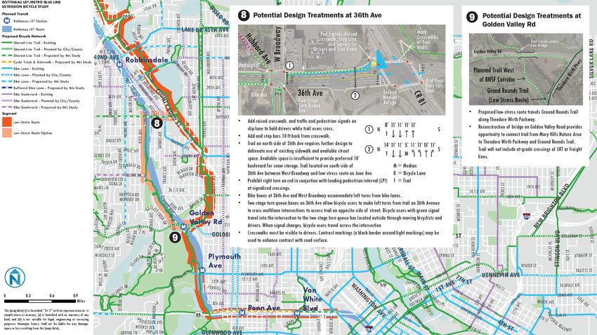
BOTTINEAU LRT / METRO BLUE LINE EXTENSION BICYCLE STUDY
                                                 Hennepin County

1 INTRODUCTION
PURPOSE OF THIS STUDY
The METRO Blue Line extension (Bottineau LRT) will bring light rail transit (LRT) to the northwest area
of the Twin Cities. With Minneapolis and Brooklyn Park at either end, the 13-mile corridor passes through
north Minneapolis and the cities of Golden Valley, Robbinsdale, and Crystal. This extension of the
METRO Blue Line (Hiawatha) will connect to the METRO Green (Central and Southwest) Line and
Northstar Commuter Rail at Target Field Station in Minneapolis. Up to 11 stations are proposed on the
Bottineau LRT line, which is expected to provide approximately 27,000 rides a day by 2030.
The purpose of this study is to assist LRT and station area planners and engineers at Hennepin County,
the Metropolitan Council, and cities along the line in ensuring that the Bottineau Transitway is optimally
accessible to bicyclists of all ages and abilities traveling to, from, across, and along the Bottineau
Transitway, including bicycle parking and other end-of-trip facilities in the station area. High quality
bicycle connections will maximize LRT ridership in a cost effective and efficient manner. They will also
allow corridor residents, many of whom experience health disparities including higher rates of obesity and
type 2 diabetes, to incorporate physical activity into routine daily life by accessing the transitway using
active transportation (walking and biking).
Hennepin County did not conduct bicycle studies for the Hiawatha (Blue Line) or Central (Green Line)
LRT projects, which were the region’s first LRT lines, opening in 2004 and 2014, respectively. These two
LRT lines are frequently used by bicyclists. Hennepin County and partner agencies are interested in even
further promoting potential connections between non-motorized transportation and transit in order to
improve accessibility and mobility throughout the region. To that end, Hennepin County undertook bike
studies in conjunction with the Southwest and Bottineau LRT lines, which are currently scheduled for
completion in 2020 and 2021, respectively.
Hennepin County’s decision to create a bicycle plan for the Bottineau LRT / METRO Blue Line extension
reflects the agency’s commitment to support station access throughout the County. This multi-
jurisdictional plan proposes prioritizing investments that improve station access by bicycle and encourage
bicycling along low stress routes that parallel the corridor for transportation and recreation.
This study was completed as an early part of engineering in close consultation with other LRT planning
efforts, including the Brooklyn Park Bicycle and Pedestrian Plan. It includes review of county-generated
demand projections, bike parking needs, network assessment within three miles of stations and
circulation analysis at LRT stations. The Study complements station area planning already underway
focused on ½ mile around each station and will be coordinated with that work.

VISION STATEMENT
Biking is a pleasant, comfortable, safe, and convenient option for traveling to, from, across, and along the
METRO Blue Line Extension Light Rail Transit (LRT). High quality bicycle connections and parking in
this corridor provide opportunities for physical activity, help residents and visitors access more
destinations, institutions, and businesses, and increase LRT ridership.

                                  Nelson\Nygaard Consulting Associates Inc. | 1-1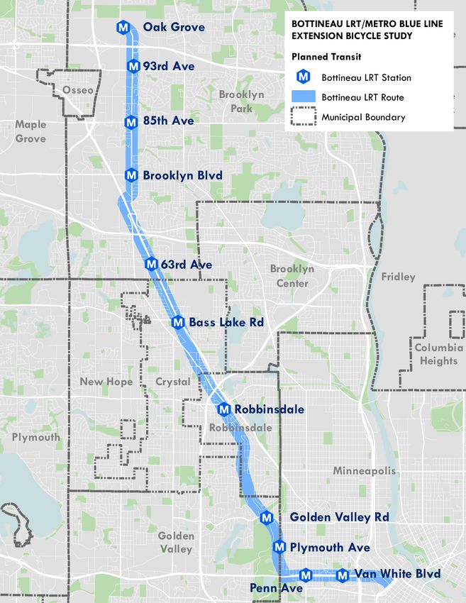
BOTTINEAU LRT / METRO BLUE LINE EXTENSION BICYCLE STUDY
Hennepin County
STRATEGIES
The study proposes the following strategies for connecting neighborhoods to LRT by bike:
Leveraging light rail transit investments
Ensuring ample, high quality bicycle parking
Connecting neighborhoods to LRT stations with trails and/or on-street facilities
Exploring options for bike share service at stations
Including wayfinding between stations, trails, and other destinations
Eliminating barriers, such as network gaps and hazardous intersections
Identifying options for a parallel corridor-length low-stress bikeway
Incorporate community input from related studies (station area planning, bike/pedestrian
planning), and continue to engage underserved and underrepresented communities in the
implementation of this study in order to ensure that all populations receive benefits from
bicycling investments.
Nelson\Nygaard Consulting Associates Inc. | 1-2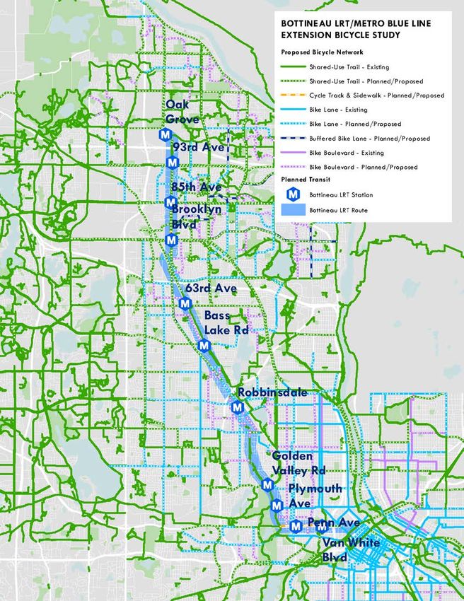
BOTTINEAU LRT / METRO BLUE LINE EXTENSION BICYCLE STUDY
                                                Hennepin County

STUDY AREA
The Bottineau LRT/METRO Blue Line Extension Bicycle Study covers bicycle transportation related to
the LRT corridor shown in Figure 1.
Figure 1    Bottineau LRT Corridor

                                 Nelson\Nygaard Consulting Associates Inc. | 1-3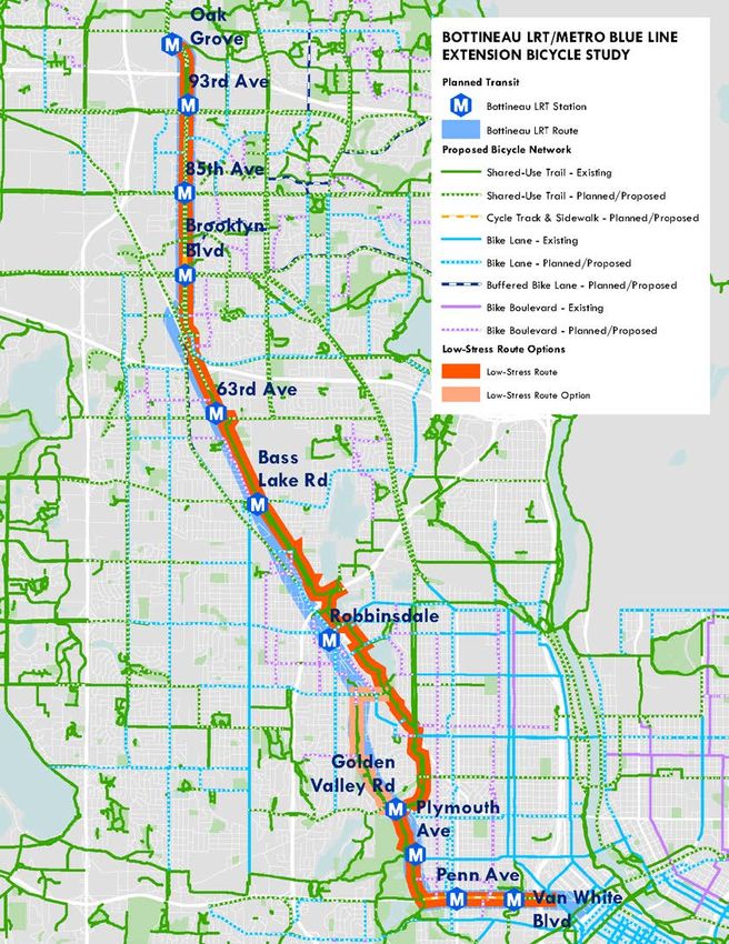
BOTTINEAU LRT / METRO BLUE LINE EXTENSION BICYCLE STUDY
                                                       Hennepin County

2 BICYCLE NETWORK
BIKESHED METHODOLOGY
This section summarizes how bikesheds were developed for the Bottineau LRT / METRO Blue Line
Extension Bicycle Study to symbolize the area easily accessible by bicycle from planned transit stations.
The “first and last mile” connections to transit within the bikeshed are critically important to extend the
reach and increase the ridership on transit.
While the Federal Transit Administration defines a bikeshed as a 3-mile radius around a transit station,
this approach does not account for variations in road network connectivity and other barriers that can
limit the area accessible on bicycle. To understand the bicycle accessibility of planned METRO Blue Line
Extension (LRT) stations, a bikeshed analysis was conducted, including on street connectivity,
topography, and energy consumption factors. The methodology is based on the approach developed by
Hiroyuki Iseki and Matthew Tingstrom. 1

Methodology
This bikeshed analysis used Geographic Information System (GIS) software to analyze bicycle access at
each of the 11 planned METRO Blue Line LRT station areas. Existing road and trail infrastructure data
was collected from municipalities in Hennepin County. Road and trail data was updated to reflect existing
conditions and changes since the GIS files were developed.
A digital elevation model of Hennepin County from the U.S. Geological Survey’s National Map website
was used to provide topographical data. Elevation data was joined with the street and trail network to
calculate the slope of each segment, traveling in each direction. After collecting and updating the data,
GIS software was used to create bikeshed areas around transit stations based on the energy required to
bicycle on streets of varying slope and to stop at various types of intersections.

Calculating the Energy Consumption of Bicycling on Streets with Slope
This analysis uses a version of the “steady-speed power equation” to estimate the total energy a bicycle
user needs to traverse a street segment, without differentiating for type of road or bicycle facility. The
equation uses the calculated slope and assumes general values for the mass of the rider, wind speed, drag,
and rolling resistance, as shown in Figure 2. While the speed of bicyclists may vary, a constant velocity is
necessary to calculate the watts of energy consumed per street segment using the following equation:
                                     Wrider = [KA * (V + VW)2 + m * g (s + CR)] * V

Iseki, Hiroyuki, and Matthew Tingstrom. 2014. "A new approach for bikeshed analysis with consideration of topography, street
connectivity, and energy consumption". Computers, Environment and Urban Systems. 48 (3): 166-177.

                                       Nelson\Nygaard Consulting Associates Inc. | 2-1
BOTTINEAU LRT / METRO BLUE LINE EXTENSION BICYCLE STUDY
Hennepin County
Figure 2 Values of Variables and Coefficients Used in Bikeshed Analysis
Variables and Coefficients Description Assumed Value
Wrider Energy consumed in watts by person bicycling To be calculated
KA Drag factor 0.245
V Velocity 4 m/s (8.9mph)
VW Wind velocity 0
m Mass of the rider 80 kg (176 lbs)
g Acceleration of gravity 9.807 m/s2
S Slope Calculated in GIS
CR Tire rolling resistance coefficient 0.004
Calculating the Energy Consumption of Bicycling Through Intersections
In addition to the energy required to traverse street segments, this analysis incorporates intersection
impedance: the energy cost of making left and right turns, as well as traveling straight through
intersections. The energy costs of making each of these movements on a network of local and arterial
streets are based on the energy required to start and stop. Some intersection movements, such as a bicycle
user making a left turn onto an arterial from a local street, are assumed to use more energy than other
movements, like making a right turn to a local street or crossing a local street. For purposes of
intersection impedance, trails are assumed to be local streets. The methodology does not account for the
impact that on-street bicycle facilities and signals may have on time delay and energy consumption at an
intersection.
Applying Energy Consumption to Bikesheds
Using the energy consumption for traversing street segments and crossing intersections, the bikeshed is
calculated for a maximum energy expenditure of 50,000 joules, equivalent to bicycling 7.08 kilometers
(4.4 miles) on flat terrain with no intersections. This threshold energy expenditure, based on the Iseki and
Tingstrom approach, is considered reasonable to capture most potential bicycle trips to transit because
the equivalent distance on flat terrain (4.4 miles) is approximately equal to the average distance of bicycle
trips found in a study of bicycle users in Portland, Oregon. 2 A majority of bicycle trips recorded in the
study were shorter than the average distance. While some people will expend more energy to bicycle to
transit, using this distance as the threshold for analysis provides a realistic bikeshed to focus plans for
connecting a range of bicycle users with LRT stations.
As this analysis uses the relative slope of street segments to calculate energy consumption, unique
bikesheds are produced for bicycle access towards a station and bicycle egress away from a station. For
example, elevation changes in the area northeast of the planned Golden Valley station result in an access
bikeshed and an egress bikeshed that do not align. The access bikeshed extends further from the station
site because bicycling downhill to the station uses less energy than bicycling uphill away from it. For each
station, access and egress bikesheds were intersected to generate a single bikeshed representing the
common area in which bicycle users could travel both to and from a single station using up to 50,000
joules of energy. Areas where the access and egress bikesheds for a single station do not overlap are
excluded from the station area bikeshed, as shown in Figure 3. While station spacing and flat terrain
allows people in some areas to access as many as four stations without exerting more than 50,000 joules,
2 Dill, Jennifer, and John Gliebe. 2008. Understanding and measuring bicycling behavior: a focus on travel time and route choice.
[Portland, Or.]: Oregon Transportation Research and Education Consortium.
Nelson\Nygaard Consulting Associates Inc. | 2-2BOTTINEAU LRT / METRO BLUE LINE EXTENSION BICYCLE STUDY
Hennepin County
this analysis assumes that people will travel to and from the station that requires the least amount of
energy expenditure.
Figure 3 Examples of Access and Egress Bikesheds
TYPES OF BICYCLE FACILITIES
The existing and proposed bicycle network is composed of a range of facilities. The predominant bike
facilities are summarized in Figure 4, based on the Hennepin County 2040 Bicycle Transportation Plan,
which contains further information on design and application.
Nelson\Nygaard Consulting Associates Inc. | 2-3BOTTINEAU LRT / METRO BLUE LINE EXTENSION BICYCLE STUDY
Hennepin County
Figure 4 Types of Bicycle Facilities
Facility Characteristics Image
Paved multi-use trails provide a shared space for bicycling,
walking and other non-motorized uses.
Some multi-use trail facilities provide designated lanes for
bicycles and pedestrians, especially where there are higher
volumes.
Trail
Can be located along streets to increase bikeway comfort
where traffic speeds or volumes are high.
Can be located outside of the street right-of-way along
abandoned or active rail corridors, waterways or through
parks.
A protected one-way or two-way bikeway separated from
adjacent motor vehicle travel lanes by a curb.
Typically include operational features to address conflicts at
intersections, such as traffic signal phases exclusively for
Cycle people biking.
Track
Bike lanes provide dedicated space for bicycling alongside
motor vehicle traffic.
Bike lanes can be a low-cost option when adequate right-of-
way is available, and often can be incorporated into roadway
Bike Lane repaving or restriping projects.
Buffered bike lanes enhance traditional bike lanes with
additional striped or buffered space between people biking
and motor vehicles.
A buffer can be incorporated to the right of the bicycle lane,
Buffered protecting people biking from the door zone of parked
Bike Lane vehicles, to the left of the bicycle lane, protecting people
biking from motor vehicles, or both.
Buffered bike lanes can be a low-cost retrofit as part of
paving or restriping.
A bicycle boulevard is typically suited for a local low-speed,
low-volume street.
Biking is prioritized by turning stops signs to prioritize bike
movements, giving bicycles the right of way, and using traffic
Bike
calming (i.e., bump outs or traffic circles), vehicle diverters,
Boulevard
enhanced signage for bicycling and other means.
Bike boulevards are intended to improve safety and comfort,
and provide an alternative to higher speed roadways that
may be intimidating to some bicycle users.
Nelson\Nygaard Consulting Associates Inc. | 2-4BOTTINEAU LRT / METRO BLUE LINE EXTENSION BICYCLE STUDY
Hennepin County
EXISTING AND PROPOSED BICYCLE NETWORK
The existing bicycle network around the Bottineau LRT corridor is centered on a robust system of trails,
both on- and off-street, that is augmented by on-street bike lanes on major roadways, and signed bike
routes on lower traffic streets. This network predominantly serves recreational bicycle users due to gaps
between destinations, and areas of population and job density. East and west bicycle routes are
particularly lacking throughout the corridor, while north and south routes are infrequent and
disconnected north of Robbinsdale. Figure 5 presents an overview of the existing bicycle network.
Figure 5 Existing Bicycle Network
Nelson\Nygaard Consulting Associates Inc. | 2-5BOTTINEAU LRT / METRO BLUE LINE EXTENSION BICYCLE STUDY
Hennepin County
The proposed bicycle network is intended to eliminate gaps in the existing bicycle network and provide
access between LRT stations and surrounding neighborhoods and destinations within the bikesheds. The
technical analysis, combined with stakeholder input, related LRT corridor studies (station area planning,
bike/pedestrian planning), and bicycle facilities planned by individual cities and Hennepin County
resulted in the proposed bicycle network, illustrated in Figure 6. Existing and Proposed facilities within
each station’s bikeshed are provided in Figures 7 through 16.
Figure 6 Proposed Bicycle Network
Nelson\Nygaard Consulting Associates Inc. | 2-6BOTTINEAU LRT / METRO BLUE LINE EXTENSION BICYCLE STUDY
Hennepin County
Figure 7 Existing Bicycle Network – Oak Grove Bikeshed
Nelson\Nygaard Consulting Associates Inc. | 2-7BOTTINEAU LRT / METRO BLUE LINE EXTENSION BICYCLE STUDY
Hennepin County
Figure 8 Proposed Bicycle Network – Oak Grove Bikeshed
Nelson\Nygaard Consulting Associates Inc. | 2-8BOTTINEAU LRT / METRO BLUE LINE EXTENSION BICYCLE STUDY
Hennepin County
Figure 9 Existing Bicycle Network – 93rd Ave, 85th Ave, Brooklyn Blvd Bikesheds
Nelson\Nygaard Consulting Associates Inc. | 2-9BOTTINEAU LRT / METRO BLUE LINE EXTENSION BICYCLE STUDY
Hennepin County
Figure 10 Proposed Bicycle Network – 93rd Ave, 85th Ave, Brooklyn Blvd Bikesheds
Nelson\Nygaard Consulting Associates Inc. | 2-10BOTTINEAU LRT / METRO BLUE LINE EXTENSION BICYCLE STUDY
Hennepin County
Figure 11 Existing Bicycle Network – 63rd Ave, Bass Lake Rd Bikesheds
Nelson\Nygaard Consulting Associates Inc. | 2-11BOTTINEAU LRT / METRO BLUE LINE EXTENSION BICYCLE STUDY
Hennepin County
Figure 12 Proposed Bicycle Network – 63rd Ave, Bass Lake Rd Bikesheds
Nelson\Nygaard Consulting Associates Inc. | 2-12BOTTINEAU LRT / METRO BLUE LINE EXTENSION BICYCLE STUDY
Hennepin County
Figure 13 Existing Bicycle Network – Robbinsdale Bikeshed
Nelson\Nygaard Consulting Associates Inc. | 2-13BOTTINEAU LRT / METRO BLUE LINE EXTENSION BICYCLE STUDY
Hennepin County
Figure 14 Proposed Bicycle Network – Robbinsdale Bikeshed
Nelson\Nygaard Consulting Associates Inc. | 2-14BOTTINEAU LRT / METRO BLUE LINE EXTENSION BICYCLE STUDY
Hennepin County
Figure 15 Existing Bicycle Network – Golden Valley Rd, Plymouth Ave, Penn Ave, Van White Blvd Bikesheds
Nelson\Nygaard Consulting Associates Inc. | 2-15BOTTINEAU LRT / METRO BLUE LINE EXTENSION BICYCLE STUDY
Hennepin County
Figure 16 Proposed Bicycle Network – Golden Valley Rd, Plymouth Ave, Penn Ave, Van White Blvd Bikesheds
Nelson\Nygaard Consulting Associates Inc. | 2-16BOTTINEAU LRT / METRO BLUE LINE EXTENSION BICYCLE STUDY
Hennepin County
KEY LOCATION: OLSON MEMORIAL HIGHWAY
This memo provides recommendations for implementing separate facilities for people walking and people
bicycling on the north side of Olson Memorial Highway. The concept of a two-way bicycle path with a
separate sidewalk for people walking has multiple advantages over a shared use path:
Separate facilities will minimize conflicts between bicyclists and pedestrians, creating a safer
and more comfortable street environment.
The sidewalk corridor, including the frontage zone and throughway zone, ensures that
building entrances do not open directly into the path of people bicycling.
New development along Olson Memorial Highway should provide active street frontages. A
separate sidewalk will support new land uses (commercial, residential, and mixed use) by
providing the space for people and potential customers to pass by and to stop at businesses.
Recommendations
Figure 17 through Figure 20 below illustrate: a) conceptual cross-sections of the north side of Olson
Memorial Highway at Penn Avenue and James Avenue; and b) a conceptual route that connects the bike
path between Van White Memorial Highway and North 7th Street, east of the I-94 overpass.
The proposed sidewalk along the north side of Olson Memorial Highway is 6-feet wide, with a two-way
10-foot wide bicycle path, which is physically separated from motor vehicle travel lanes by a buffer that
may vary between 10 feet and 12 feet in width to accommodate snow storage, BRT stops, streetscaping,
and lighting. While 10 feet is desired for snow storage, a wider buffer may be desirable at BRT stops.
Considerations and recommendations for these concepts as listed below are called out on the illustrations:
1. Mark crosswalks on the bike path between the BRT stop and the sidewalk to indicate to both
pedestrians and bicyclists where to cross, concentrate pedestrian activity in the marked location,
and decrease potential conflicts. Crosswalks must be visible to motorists, especially at night.
Contrast markings, such as a black border around light markings, may be used to enhance
visibility to enhance contrast with the road surface.
2. Methods to support the path crossing include a speed table on the bike path and/or advanced
yield markings for bicyclists as well as bicycle crossing markings to alert pedestrians.
3. At corners, utilize distinctive pavement treatments and yield markings to highlight the shared
space and emphasize bicyclists’ responsibility to yield to pedestrians.
4. A crosswalk can be marked where the bicycle path crosses the desire line of pedestrians north and
south along Penn Avenue, James Avenue, and other north-south streets. The crosswalk tells
bicyclists to yield to pedestrians while the bicycle pavement markings help alert pedestrians.
5. The bike path and sidewalk can be delineated with design elements such as a raised curb, varied
surface materials, or other small buffers.
6. The buffer on the north side of the sidewalk varies in dimensions and use. At Penn Avenue and
James Avenue, existing buildings are currently set back at least 70 feet, while existing sidewalks,
service roads, and structures are in closer proximity along the corridor. In general, the
dimensions used in these concepts are best practice for the safety and comfort of users. However,
there is flexibility within these concepts to work around various constraints.
7. Pedestrian signal heads should include adequate time to fully cross the street. Pedestrian-
clearance intervals should meet the walking speed standards in the MUTCD (3.5 feet per second)
at a minimum. A walking speed of less than 3.5 feet per second should be considered in these
clearance intervals at locations where pedestrians who may need more time routinely cross, such
as the elderly or those in wheelchairs.
Nelson\Nygaard Consulting Associates Inc. | 2-17BOTTINEAU LRT / METRO BLUE LINE EXTENSION BICYCLE STUDY
Hennepin County
8. Intersection crossing markings should be included for bicyclists at any existing bicycle path across
Olson Memorial Highway.
9. The buffer between the bicycle path and motor vehicle travel lanes is recommended to be a
minimum of 10 feet wide for snow storage, lighting, and landscaping, although there are pinch
points where this may not be achieved.
Olson Memorial Highway at Penn Avenue
At Penn Avenue there is a proposed BRT stop on the north side of Olson, in addition to the median LRT
station. In this concept, the bicycle path remains behind the bus stop in order to minimize conflicts
between path users and passengers boarding and alighting from the bus. A separate sidewalk facility
provides more comfortable space for people walking and accessing potential mixed-use development on
the north side of Olson. The shared space at the corner could be treated with alternative pavement
treatments to delineate the path of travel for through bicycle riders. Additional examples for designing
bike paths at bus stops are included in the following section.
Figure 17 Proposed Configuration of Olson Memorial Highway (North Side) at Penn Avenue
Note: Buildings illustrated are not planned, but included to show potential relationship between proposed sidewalk facility and possible future
development along Olson Memorial Highway.
Nelson\Nygaard Consulting Associates Inc. | 2-18BOTTINEAU LRT / METRO BLUE LINE EXTENSION BICYCLE STUDY
Hennepin County
Figure 18 Plan View Sketch of Olson Memorial Highway (North Side) at Penn Avenue
Olson Memorial Highway at James Avenue
There is no proposed LRT station or BRT stop on Olson Memorial Highway at James Avenue. In this
concept, the bicycle path is separated from motor vehicle travel lanes by a buffer. The shared space at the
corner could be treated with alternative pavement treatments to delineate the path of travel for through
bicycle riders.
Nelson\Nygaard Consulting Associates Inc. | 2-19BOTTINEAU LRT / METRO BLUE LINE EXTENSION BICYCLE STUDY
Hennepin County
Figure 19 Proposed Configuration of Olson Memorial Highway (North Side) at James Avenue
Figure 20 Plan View Sketch of Olson Memorial Highway (North Side) at James Avenue
Nelson\Nygaard Consulting Associates Inc. | 2-20BOTTINEAU LRT / METRO BLUE LINE EXTENSION BICYCLE STUDY
Hennepin County
Olson Memorial Highway across the I-94 Bridge
Between Van White Memorial Highway and the I-94 bridge there is insufficient space to continue the
bicycle path and sidewalk treatment proposed above in the existing right of way. Installing a bicycle path
and separate sidewalk would require using private property or reducing the buffer on the street side, both
actions that could require removal of existing trees. The I-94 bridge also does not possess sufficient space
to provide separate facilities for bicycling and walking at this time.
For opening day of the light rail, the proposed concept shown in Figure 21 provides a shared use path on
the north side of Olson Memorial Highway between Van White Memorial Highway and the I-94 bridge.
Although below current construction standards, the most practical option to connect the path across the
bridge is to create a two-way shared use path using the existing sidewalk. As this section of shared use
path will be between 8 and 9 feet wide, future bridge work should include a replacement to standard
dimensions. Bicycle users may also choose to use the trail on Van White Memorial Boulevard to connect
to the bicycle lanes on Glenwood Avenue as an alternate connection across I-94.
In the future, the replacement of the I-94 bridge should include a 6-foot wide sidewalk along the north
side with a two-way 10-foot wide bicycle path, as shown in Figure 22. Physical separation between the
bicycle path and vehicle travel lanes may be provided using buffer space or a vertical barrier with
sufficient clearance.
Figure 21 Proposed Olson Memorial Highway Bicycle Route across the I-94 Bridge for Opening Day
Figure 22 Proposed Olson Memorial Highway Bicycle Route across I-94 Bridge with Future Bridge Reconstruction
KEY LOCATION: WEST BROADWAY
Figure 23 presents a proposed concept for LRT stations on West Broadway, including Brooklyn
Boulevard, 85th Avenue, and 93rd Avenue. A trail facility is planned for both sides of West Broadway. To
provide additional space for pedestrians near transit stations, separate sidewalk facilities along
commercial properties can be added during redevelopment. Specific dimensions are dependent on the
land use and active frontage of redeveloped properties. In additional, commercial properties near transit
stations should be considered as potential opportunities to create plazas or other public space.
Nelson\Nygaard Consulting Associates Inc. | 2-21BOTTINEAU LRT / METRO BLUE LINE EXTENSION BICYCLE STUDY
Hennepin County
Figure 23 West Broadway Bicycle Facility Concept
Nelson\Nygaard Consulting Associates Inc. | 2-22BOTTINEAU LRT / METRO BLUE LINE EXTENSION BICYCLE STUDY
Hennepin County
KEY LOCATION: GOLDEN VALLEY STATION BICYCLE ACCESS
Figure 24 presents the Bottineau Project Office proposed concept for parking facilities at the Golden
Valley Road station. If parking facilities are not included in the final plan, a path is recommended to
connect the station platform with trails on Golden Valley Road and Theodore Wirth Parkway. In addition,
by making the ADA-accessible elevator large enough to accommodate bicycles and including a bike rail to
roll bicycles in the stairwell, station access will be improved. As the owner of the property, the
Minneapolis Park Board should be involved with design, placement, and maintenance of facilities.
Nelson\Nygaard Consulting Associates Inc. | 2-23BOTTINEAU LRT / METRO BLUE LINE EXTENSION BICYCLE STUDY
Hennepin County
Figure 24 Golden Valley Road Station Bicycle Access
Nelson\Nygaard Consulting Associates Inc. | 2-24BOTTINEAU LRT / METRO BLUE LINE EXTENSION BICYCLE STUDY
Hennepin County
STRATEGIES FOR BICYCLE PATHS IN HIGH-ACTIVITY PEDESTRIAN
AREAS
Pathways through high-activity pedestrian areas near transit stops should be designed to minimize
conflict between users. In addition to the recommendations for signal phasing, pavement markings, and
buffers described for the Olson Highway concepts, the following design solutions can be considered to
minimize conflicts between users.
Slow Path Users Approaching Station
Slight chicanes and pinch points can be used to slow path users in advance of the station area, which can
be designed to function as a shared space for low-speed bicyclist and pedestrian use. The diagram below
shows a slight chicane to slow path users passing behind a transit stop.
Figure 25 Bicycle Path Passing Behind Transit Stop
Path Widening at Transit Stop
Increasing the width of the bike path around a transit stop provides path users and transit users more
space to safely navigate around each other, as seen in the example below of a bicycle path passing a bus
stop in Changzhou, China.
Figure 26 Wider Bicycle Path at Transit Stop
Path Widening at Intersection
The path can also be widened at intersection crossings where queuing results in crowding at the edge of
the roadway. Widening the path can increase crossing capacity and help reduce conflicts between path
users, as well as pedestrians crossing perpendicularly to access the BRT or LRT stops.
Nelson\Nygaard Consulting Associates Inc. | 2-25BOTTINEAU LRT / METRO BLUE LINE EXTENSION BICYCLE STUDY
Hennepin County
Raised Crossings
Raised crosswalks (speed tables) ramp the roadway to the elevation of the sidewalk so that vehicles or
bicycles are slowed in advance of a pedestrian crossing. Raised crosswalks are typically utilized at high
volume pedestrian crossings or at locations that have demonstrated a significant safety risk. Truncated
domes or other surface markings should be placed at the edges of the raised section to alert pedestrians
with visual impairments of the sidewalk edge. Figure 27. shows an example of a two-way cycle track in
Seattle that passes over a raised crossing to give bicyclists warning and slow their approach. Figure 28
shows a raised crosswalk across the Hudson River Greenway at an office building in New York City. In-
pavement lights begin flashing when nearby motion sensors detect the approach of bicyclists or other
people using the greenway.
Figure 27 Two-way cycle track with raised crossing behind a bus stop (Seattle, WA)
Figure 28 Raised crosswalk across bike path with motion-activated flashing lights (New York, NY)
Guide Bus Passengers to Marked Crossings
Fencing can be used behind a transit stop to guide passengers exiting the bus to cross a bike path at a
marked crosswalk or preferred location, without reducing access to the station. Examples of this strategy
are shown above and below where simple fencing or bollards encourage crossing at specific locations
rather than anywhere along the length of the bus stop.
Nelson\Nygaard Consulting Associates Inc. | 2-26BOTTINEAU LRT / METRO BLUE LINE EXTENSION BICYCLE STUDY
Hennepin County
Figure 29 Cycle track and bus stop (Warsaw, Poland)
Signal Synchronization
Prioritize the movement of path users through station areas prior to the arrival of a light rail train or BRT
to reduce conflicts. If bicyclists are passing the station as the light rail train or bus is approaching,
passengers will be mainly waiting on the platform, rather than crossing the path. This can be
accomplished by using leading bicycle intervals or separate bicycle phasing that prioritizes the movement
of the bicycles at adjacent signalized intersections.
Nelson\Nygaard Consulting Associates Inc. | 2-27BOTTINEAU LRT / METRO BLUE LINE EXTENSION BICYCLE STUDY
Hennepin County
FUNDING OPPORTUNITIES
Once a community has decided to improve biking options, it needs the resources to do so. Various funding
sources and programs are available to fund the implementation of the proposed bicycle network in
Hennepin County. The following table presents funding opportunities that may be available to eliminate
gaps and build out the bicycle network.
Figure 30 Potential Funding Opportunities
Funding Source Description Opportunities
Large trails or trail networks with a transportation purpose
Trail projects in urban areas have
can compete for TIGER grant awards. Additional
traditionally been funded at a minimum of
significant federal funding sources include TAP, STP and
Federal Funding $10,000,000 and rural trails of lower
CMAQ. Depending upon the location and purpose, trails
project costs are considered for TIGER
can also be funded by HUD CDBG funds, USDA rural
funding.
development programs, or EPA funding.
Programs include: Trails
State of Corridor Investment Management Strategy Bike Lanes
Minnesota Parks and Trails Fund Sidewalks
State Bonds Crossings
The Livable Communities Demonstration Account is
Metropolitan intended to fund local and regional projections that link Trails
Council housing, jobs, and other destinations through Bike Lanes
transportation networks.
Programs include:
Complete Streets Cost Participation Policy Trails
Hennepin County Capital Improvement Program Bike Lanes
Transit Oriented Development Grant Sidewalks
Roadside Enhancement Partnership Program
National Center Trails
for Safe Routes Safe Routes to School grants provides funding for bicycle
Bike Lanes
and pedestrian facilities along routes to schools
Sidewalks
Public/private partnerships are agreements between public Streets
and private partners that can benefit from the same Sidewalks
Public/Private improvements. They have been used in several places
Bike lanes
Partnerships around the country to provide end-of-trip facilities at public
transit stations in exchange for operational revenue from Trails
the facilities. Transit
Donations from private organizations and corporations can
be accepted by many municipalities for capital projects. Trails
Private Sidewalks
Private developers and institutions in the LRT service area
Organization and
may be willing to fund projects that help improve the safety Bike Lanes
Corporate Donors
and convenience of accessing, their facilities, in addition to Bike Parking
improving their desirability
Nelson\Nygaard Consulting Associates Inc. | 2-28BOTTINEAU LRT / METRO BLUE LINE EXTENSION BICYCLE STUDY
Hennepin County
3 LOW STRESS ROUTE
In addition to traveling to and from LRT stations, bicycle users may need to travel between stations to
access the unique businesses, services, and opportunities in each station area. The low stress route helps
facilitate these trips along the LRT corridor for people to bicycle either one way or both ways, and use the
LRT as part of a trip. The following is a proposed concept for a “low stress” bicycle route that connects all
station areas along the Bottineau LRT line.
Some LRT corridors, such as the METRO Blue Line (Hiawatha Line) in Minneapolis, have multi-use trails
running parallel to the LRT. Due to limited right of way in the freight corridor, a rail trail is not feasible
for the Bottineau LRT. This chapter proposes several concepts for corridor long routes that are “low
stress” for people biking along the corridor, but not necessarily accessing stations. These routes would be
designed with a high level of protection, including trails, cycle tracks, and improvements at intersections,
so that people who are not comfortable riding in the street with automobile traffic would be comfortable
with this corridor long route. To improve the level of comfort and safety for trail users, design treatments
are proposed for specific road crossings and connections, in addition to prototypical treatments for other
crossings along the route. Wayfinding strategies are also proposed to guide trail users along the route and
to nearby destinations.
Nelson\Nygaard Consulting Associates Inc. | 3-1BOTTINEAU LRT / METRO BLUE LINE EXTENSION BICYCLE STUDY
Hennepin County
PROPOSED LOW STRESS ROUTE
Figure 31 Proposed Low Stress Route
Nelson\Nygaard Consulting Associates Inc. | 3-2BOTTINEAU LRT / METRO BLUE LINE EXTENSION BICYCLE STUDY
Hennepin County
Figure 32 Low Stress Route Map (Oak Grove, 93rd Ave, 85th Ave, Brooklyn Blvd)
Nelson\Nygaard Consulting Associates Inc. | 3-3BOTTINEAU LRT / METRO BLUE LINE EXTENSION BICYCLE STUDY
Hennepin County
Figure 33 Low Stress Route Map (Brooklyn Blvd, 63rd Ave, Bass Lake Rd)
Nelson\Nygaard Consulting Associates Inc. | 3-4BOTTINEAU LRT / METRO BLUE LINE EXTENSION BICYCLE STUDY
Hennepin County
Figure 34 Low Stress Route Map (Brooklyn Blvd, 63rd Ave, Bass Lake Rd)
Nelson\Nygaard Consulting Associates Inc. | 3-5BOTTINEAU LRT / METRO BLUE LINE EXTENSION BICYCLE STUDY
Hennepin County
Figure 35 Low Stress Route Map (Robbinsdale, Golden Valley Rd, Plymouth Ave, Penn Ave, Van White Blvd)
Nelson\Nygaard Consulting Associates Inc. | 3-6BOTTINEAU LRT / METRO BLUE LINE EXTENSION BICYCLE STUDY
Hennepin County
PROTOTYPICAL CROSSING TREATMENTS
The completeness of the low-stress route corridor with safe, comfortable, and convenient crossings for
people walking and bicycling is a basic requirement. The following memo focuses on prototypical crossing
treatments for the proposed low stress route. In general, crossings are categorized as:
Major intersection crossing (4+ lanes)
Minor intersection crossing (2 lanes)
Major mid-block crossing (4+ lanes)
Minor mid-block crossing (2 lanes)
Driveway crossing
Other/Complex crossing (requires further design)
General Principles
Make crossings as short as possible. Crosswalks must be visible to drivers, especially at night.
Contrast markings, such as a black border around light markings, may be used to enhance
contrast with the road surface. Add stop bars in advance of crosswalks to increase the distance
between vehicles and people crossing the street.
Ensure clear sight lines and distance are provided at crossings.
Improve visibility for trail users and road users at crossings by designating clear space, and
removing or avoiding obstructions to sight lines.
At signalized crossings, increase the amount of crossing time for pedestrians.
Consider leading pedestrian intervals to hold vehicles until trail users have started crossing.
Intersections between trail and roadway should be designed at a right angle.
Include sufficient lighting to illuminate crossing for drivers and trail users.
Major Intersection Crossing
Existing Characteristics
4 or more travel lanes
Intersection is controlled by traffic signal
Trail is located parallel to a road
Design Recommendation
Install curb extensions in shoulder or parking lanes to decrease crossing distance if space is
available.
Install an ADA accessible median refuge if space is available. If space is not available, install
narrow median or bollard to control vehicle turning movements.
If ADA accessible median refuge is installed, and longest leg of crossing is two lanes, create raised
trail crossing.
Install signal heads for bicycle and pedestrian trail crossing and phase. Prohibit right turn on red
across the trail.
Warning signs may be used on the street and trail to indicate the presence of a crossing in
advance.
Nelson\Nygaard Consulting Associates Inc. | 3-7You can also read