F
Bishopstown
to City
Sustainable Transport Corridor
Emerging Preferred Route
Public Consultation June 2022
←
→
Page content transcription
If your browser does not render page correctly, please read the page content below
F Bishopstown to City Sustainable Transport Corridor Emerging Preferred Route Public Consultation June 2022

Contents
1. Introduction                                                                          4
  1.1 Investing in Cork’s Future: Cork Metropolitan Area Transport Strategy (CMATS)
      - Reimagining Public Transport in Cork                                             4
  1.2 What is BusConnects Cork?                                                          6
  1.3 What is the Sustainable Transport Corridor Project?                                9
  1.4 Potential Road Layout                                                              10
  1.5 What are the benefits of the Sustainable Transport Corridor Project?               10
  1.6 Emerging Preferred Routes                                                          12
2. Emerging Preferred Routes                                                             14
  2.1   Emerging preferred route for Bishopstown to City                                 14
  2.2   Bishopstown to City Overview                                                     14
  2.3   Key Facts                                                                        21
  2.4   Understanding the terminology                                                    22
3. Understanding Potential Challenges and Ways to Mitigate                               24
  3.1 Overview                                                                           24
  3.2 Challenges and how we will mitigate to address them                                25
4. The Process for the Acquisition of Land                                               28
  4.1 How the Project will progress through public consultations until Formal Planning   30
5. How to take part in the public consultation and have your say                         32
  5.1 If a property owner has land that may be impacted                                  32
  5.2 General queries                                                                    32
  5.3 How to send a submission                                                           32
6. Appendices                                                                            34
  Index Map                                                                              35
  Route Maps                                                                             36
BusConnects Cork Sustainable Transport Corridors / F. Bishopstown > City

1. Introduction                                         transport options, along with radically improved
                                                        cycling and walking infrastructure.
                                                                                                            Cork Metropolitan Area Transport
                                                                                                            Strategy (CMATS) means:

1.1 Investing in Cork’s Future:                         Putting transport at the heart                      A multi-billion Euro investment in transport for
                                                                                                            the Cork Metropolitan Area over the next two
Cork Metropolitan Area                                  of the vision for Cork
                                                                                                            decades delivering;
Transport Strategy (CMATS)
                                                        CMATS sets out an ambitious vision to deliver
- Reimagining Public                                    an accessible, integrated transport network         Ĥ A transformed bus system - BusConnects
Transport in Cork                                       that enables the sustainable growth of the Cork       Cork;
The National Transport Authority (NTA) is               Metropolitan Area as a dynamic, connected, and
                                                        internationally competitive European city region.   Ĥ An enhanced commuter rail system – Cork
committed to enabling Cork’s growth potential
                                                                                                              Commuter Rail Programme;
and supporting its future development. That’s
why the NTA has been working in partnership             The implementation of CMATS is aligned with a       Ĥ A new east-west light rail line - Luas Cork;
with Cork City Council, Cork County Council, Irish      broad national policy framework, supporting
Rail, Bus Éireann and Transport Infrastructure          regional development, economic growth,              Ĥ A comprehensive cycling network providing
Ireland, to develop, and now implement the Cork         climate action and investment in sustainable          safe cycling facilities across the region;
Metropolitan Area Transport Strategy (CMATS).           transport. This framework includes:                 Ĥ Various new road links and road
                                                                                                              improvements plus park & ride provision; and
Adopted in 2020, CMATS will deliver an                  Ĥ National Development Plan 2021-2030
accessible, integrated transport network that                                                               Ĥ Enhanced pedestrian facilities.
                                                        Ĥ Climate Action Plan 2021
enables the sustainable growth of the Cork
Metropolitan Area as a dynamic, connected, and          Ĥ National Planning Framework 2040                  CMATS will result in more than half of all
internationally competitive European city region.                                                           journeys in the morning peak being made
                                                        Ĥ National Sustainable Mobility Policy              by public transport, cycling and walking when
CMATS is about creating a liveable city and                                                                 the Strategy is delivered compared to just
connected communities by giving everybody                                                                   26% at present.
the opportunity to access sustainable public

4
BusConnects Cork Sustainable Transport Corridors / F. Bishopstown > City

                                                                       5
BusConnects Cork Sustainable Transport Corridors / F. Bishopstown > City

1.2 What is BusConnects Cork?                           BusConnects Cork will enhance the capacity
                                                        and potential of the public transport system.
To help Cork city and county fully realise this         It will support the delivery of a low carbon and
vision for the future, the NTA is planning an           climate-resilient public transport system in
investement of half a billion Euro to develop           addition to greatly improving accessibility to
Sustainable Transport Corridors, revamping key          jobs, education whilst playing a key role in
roads and streets to enhance provision for              regeneration and improvements to public
buses, cyclists and pedestrians, as a key               realm and City Centres.
component of BusConnects Cork.

For the people of Cork, this investment will
mean greater connectivity to employment, to
education, to family and friends, to retail and to
the burgeoning social and cultural fabric of the
region.

This will help the city achieve its climate goals,
become more sustainable, contribute to growing
the economy, improve accessibility and drive
down journey times in the city.

BusConnects is the NTA’s programme of
bus service improvement in Irish metropolitan
areas. BusConnects Cork will entail a €600m
investment and includes nine measures which
will transform Cork’s bus system, making public
transport more useful to more people.

6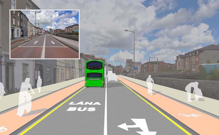
BusConnects Cork Sustainable Transport Corridors / F. Bishopstown > City

                                                                                                                                 +           +       +               +
                                                                                                                     +       +           +               +
                                                                                                                             +           +       +               +

                                                                                                                             +           +           +               +
                                                                                                                 +   +       +                +
                                                                                                                         +           +       +               +

Enhance the capacity and potential of the          Support the delivery of an efficient, low-carbon       Improve accessibility to jobs, education
public transport system by improving bus           and climate-resilient public transport service,        and other social and economic opportunities
speeds, reliability and punctuality through the    which supports the achievement of Ireland’s            through the provision of improved sustainable
provision of bus lanes and other measures to       emission-reduction targets                             connectivity and integration with other public
provide priority to bus movement over general                                                             transport services
traffic movements

                                                   Enable compact growth, regeneration                    Ensure that the public realm is carefully
Enhance the potential for cycling by providing     opportunities and more effective use of land           considered in the design and development
safe infrastructure for cycling, segregated from   in Cork, for present and future generations,           of the transport infrastructure and seek to
general traffic wherever practicable               through the provision of safe and efficient sus-       enhance key urban focal points where
                                                   tainable transport networks                            appropriate and feasible

                                                                                                                                                                         7
BusConnects Cork Sustainable Transport Corridors / F. Bishopstown > City

BusConnects Cork aims to overhaul the current transport system in
the Cork Metropolitan Area through:

    1                               Building a network
                                                                2               Completely                3   New state
                                    of new Bus                                  redesigning                   -of-the-art
                                    and Cycle                                   the bus                       ticketing
                                    Corridors                                   network                       system

        4                                           5                                                6           New
                                                        €€
               Implementing                                                Revamping
              Cashless                                                     the fare system                       bus
              payment                                                                                            livery
              system

                                New bus
    7                                                       8                    New Park                 9    Transitioning
                                                                                                               to a zero
                                stops and
                                shelters
                                with better signage
                                                                 P+              & Ride
                                                                                 sites in key locations
                                                                                                               emissions
                                                                                                               bus fleet
                                and information

8
BusConnects Cork Sustainable Transport Corridors / F. Bishopstown > City

A number of the initiatives are already          1.3 What is the Sustainable                            The proposed Sustainable Transport Corridors
underway including the redesigning of the                                                               will feature new cycling and walking infrastruc-
                                                 Transport Corridor Project?
Bus Network in the Cork metropolitan area                                                               ture as well as improving bus priority on roads
which had two rounds of public consultation      The proposals are to invest in Sustainable             and streets in Cork. The new corridors will help
during 2021. The Final Redesigned Bus            Transport Corridors that will have continuous          improve the number of people walking and
Network for Cork was recently published and      bus priority – generally, a continuous bus lane in     cycling to work and college, shopping, meeting
will be implemented during 2023 / 2024.          each direction, but other arrangements are used        friends; while radically improving the frequency
                                                 in constricted locations. This will remove the         and reliability of bus services across the city.
The restructuring of the fare system             delays currently being experienced by the bus
                                                 system, which will grow worse as congestion
with a new 90-minute fare, that will allow
                                                 increases, and allow the buses to transport their
                                                                                                                 93km of bus lane/
passengers to take multiple trips on various
modes of transport within 90 minutes of          many thousands of passengers with greater                          bus priority
one another without incurring any additional     certainty about the arrival times to their
financial penalty. Transitioning the bus fleet   destinations.
from diesel to fully electric zero-emissions
vehicles is also a cornerstone of the            Along these corridors, we also intend to
BusConnects programme. This transition is        provide segregated cycle tracks in each                    112km of cycle facilities
already underway in Ireland’s major cities
with the first fully electric buses for Cork
                                                 direction, separated as far as is practically
                                                 possible from general traffic. In areas where
                                                                                                                (one direction)
planned to be delivered in 2023.                 this may prove difficult to achieve, we intend to
                                                                                                              delivering 56km of
                                                 provide offline cycle tracks, where a cycle track             the cycle network
                                                 will divert off the Sustainable Transport Corridor
                                                 and onto a quieter road or purpose-built
                                                 cycleway, before re-joining with the corridor.

                                                                                                                                                           9
BusConnects Cork Sustainable Transport Corridors / F. Bishopstown > City

1.4 Potential Road Layout                                1.5 What are the benefits                           Consistently faster and more predictable journey
                                                                                                             times means a more reliable bus system. This
To create the Sustainable Transport Corridors
                                                         of the Sustainable Transport
                                                                                                             improved reliability will make public transport in
changes to current road layouts will need to be
                                                         Corridor Project?                                   Cork more appealing to more people, and
designed and built. The new design will allow            The Sustainable Transport Corridors being           resourcing the bus services with drivers and
for improved footpaths, segregated cycle tracks          proposed to realise the vision of the Cork          buses will become more streamlined.
where achievable and dedicated bus lanes to              Metropolitan Area Transport Strategy will achieve
remove the buses from congestion. An example             a number of benefits which will have far-reaching   1.5.2 Better Environment
of a road layout is shown below – however, this          influence on all modes of transport in Cork.        for Cyclists
layout is only possible in certain areas.
                                                                                                             BusConnects Cork entails much more than just
                                                         1.5.1 Improved Bus
All of the routes are at Emerging Preferred                                                                  investment in buses and bus lanes, in fact, this
                                                         Journey Times
Route (EPR) options at this stage. There will                                                                plan will provide much needed cycling facilities
be extensive public consultation undertaken in           By improving the roads and infrastructure that      and make it easier, safer and more attractive to
relation to these proposals and it is likely that        the bus services operate on, ultimately BusCon-     cycle around the Cork City region.
various refinements and changes will be                  nects Cork will achieve a much more efficient
incorporated as that public engagement and               bus system for Cork. By improving bus priority      Only 1% of the 803,000 trips that are made
dialogue progresses.                                     across the city, journey times will be reduced      in the Cork Metropolitian Area on an average
                                                         and will become much more predictable.              weekday are made on bicycles. A significant
                                                                                                             factor in the low number of cyclists is the lack of
                                                                                                             safe cycling infrastructure and the Sustainable
                                                                                                             Transport Corridor Project aims to significantly
                                                                                                             improve this by building a network of cycle lanes
                                                                                                             and cycle tracks that will make up the core of
                                                                                                             the region’s cycling network.

                      CYCLE                                                       CYCLE
           FOOTPATH   TRACK   BUS LANE   TRAFFIC LANE   TRAFFIC LANE   BUS LANE   TRACK   FOOTPATH
                                                                                                             The major Sustainable Transport Corridors
                                                                                                             across the metropolitan area are also the main

10
BusConnects Cork Sustainable Transport Corridors / F. Bishopstown > City
cycling arteries. The reconfiguration of A key component of the Sustainable accessible public transport will allow people of
these roads for bus lanes provides the op- Transport Corridors project is to use this unique all ages and abilities to reach their full potential
portunity to transform the cycling opportunity to create a better environment for and participate wholly in society.
infrastructure at the same time. pedestrians as we improve these corridors. In
particular, we will look to add new footpaths in 1.5.5 Supporting the Economy
On each of the 12 Sustainable Transport areas where they are currently lacking, improve
the quality of footpaths and pedestrian crossings, A well-functioning public transport system is
Corridors, our objective is to invest in
as well as expanding pedestrian facilities at a basic requirement for any metropolitan area
and provide high-quality cycling facilities,
junctions. We will also enhance key local centres that aspires to provide plenty of employment
segregated from the bus lanes and gen-
with public realm improvements including opportunities for its people into the future. With
eral traffic lanes as far as is practicable.
additional landscaping and outdoor amenities. bus and rail, Cork boasts some excellent services
Approximately 112km of cycle facilities (in
but if it is to achieve its potential as the fastest
one direction) will be built which will de-
growing city in Ireland, and to continue to attract
liver 56km of the cycle network. A better 1.5.4 Sustainable and
the best jobs and the best employers, we have
cycling network is good for all transport Liveable City
to develop a transport system that will meet the
users. It avoids cyclists sharing general
BusConnects Cork is about making sustainable needs of such a rapidly developing region.
traffic lanes or bus lanes with buses and
will remove many of the conflicts between transport a better and more accessible option.
general traffic, buses and cyclists. The By providing a high-quality, frequent and Creating dedicated bus lanes and safer cycling
cycling infrastructure delivered under this reliable bus service, and improving cycling and facilities will make journeys by bus or on a bike
programme will form the core of the re- pedestrian infrastructure, we can make Cork more convenient, attractive and reliable. It will
gion’s cycling network and deliver a radical a more attractive place to live, work and visit. allow people to plan journeys with confidence
stepchange in cycling facilities in Cork. Moving some people from their cars onto buses, and therefore make Cork a more attractive
bicycles and footpaths will make Cork a less location for employers, leading to increased
congested, and more climate friendly region. economic activity and the regeneration of the
1.5.3 Enhanced Facilities for More areas of the region will be accessible by City. It will also make it easier for people to get
Pedestrians public transport and the inclusion of people with out and enjoy the city and all it has to offer,
Cork’s pedestrian facilities have been a additional needs will be carefully considered at which is good news for businesses in the city
concern in many areas for many years. all stages of the design process. Effective and centre and beyond.
11BusConnects Cork Sustainable Transport Corridors / F. Bishopstown > City
1.6 Emerging
Preferred
Routes
Sustainable
Transport
Corridors
A Dunkettle to City
B Mayfield to City
C Blackpool to City
D Hollyhill to City
E Ballincollig to City
F Bishopstown to City
G Togher to City
H Airport Road to City
I Maryborough Hill to City
J Mahon to City
K Kinsale Road to Douglas
L Sunday’s Well to Hollyhill
Sustainable Transport Corridor
Alternative Cycle Facilities
12BusConnects Cork Sustainable Transport Corridors / F. Bishopstown > City
SALLYBROOK
To
w
er
Cr
R639
os
s
nn’s
Rd BLARNEY Hazelw
ood Rd
Rd
A
St
oly
Ballyho
Hill
Ann’s RIVERSTOWN
St
N20
Hill
Rd
TOWER wn
Rd nto
Ol
Dublin
al Gly
Ma gh
d
u
llow Yo
Rd
Blackpool to City Core Bus Corridor (CBC C)
ld
O
Mayfield to City Core Bus Corridor (CBC B)
ds
Upper
klan
Par Co
Ba m mo
wn
na s ns
fin en Rd DUBLIN HILL
ny
GLANMIRE
ille
Glenthorn
BALLYVOLANE al
gh
Lo wer K ts Yo
u
Glen
heigh
Old
CLOGHROE
Up
p
Ballincollie
er
Fa
C
FARRANREE
B
Dunk
ir
N Ring Rd
hil
l
ld
ettle
irfie
Rd
Fa
g
Rin
N
Rd
R639
e
cours
oly MAYFIELD
lyho
Hollyhill to City Core Bus Corridor (CBC D) Glen Ave Bal
field hal Rd
Water
ch Youg
Chur Old
BLACKPOOL
eld
Fi
r
ins
Lowe
Cron
e Rd
W
A
lmor
Dunkettle to City Core Bus Corridor (CBC A)
olf
N Ri
Ki
To
O’Conne
ll
CHURCHFIELD
ne
KNOCKNAHEENY
ng Rd
D
ew
Carroll’s Quay
r Vi
Upper John
Monastery
rbou
Sunvalley
St Colmci Rd
Ha lle’s
hal
Youg
Baker’s Rd
Old
Cathedral
CITY
MONTENOTTE
N8
Richmo
Roma
n N20 ire
CENTRE Glanm
Lower
nd Hill
Cathedral Rd
Bla HOLLYHILL SHANDON ll N
Gu
St Patricks
rne erhi
John Redmond
rra
n
mm
ne
ndo
yS
bra
Su
t
Sha
GARRANABRAHER
he
ire
r
nm
Hill
Pop er Gla
ney Low
L
Blar e’s MacCurt
Qu ain
Blarney St ay Alfred
an’s
Qua
y
Bridge
Camden Place Horg
y St Patrick’s
Ship
r’s Qua Quay
Brn Bru
N
helo
THE MARSH
St
Mercha
St
Bac
Ma
Penrose Quay
N40
nt’s Quay
ide
in
ela le Lavitt’s Quay
Ad Ky
St
St Paul’s
e
ridg
Gra
wb
ller
Castle Rd
y
Dra
nr
tta
He
lle Grenvi
DOCKLANDS
Mahon to City Core Bus Corridor (CBC J)
n
Ac
Lee
Sundays Well to Hollyhill Core Bus Corridor
Maylo
(CBC L)
Shanak ll Rd r
ade
Albe
M
St Pat
We
Roa iel Rd ay’s
stle
Clo
rick
arq
Ca
my
’s
Sund
Sheares
rt
d
Grenvi
Parn
nta
Liberty
ue
Vi
rf
ct
ell
Rd
e
gton or
Centre Park
ia
y
Washin kett
Gra
er Plun
Carrigroh
Oliv Albert
nd Para
e
Maryv
de
R608
Egl
Fern
e Para
ane Dyk y
into
l ua e
An
S Mal Q
S Mai
rac
de
Wandesford Quay n Ter
n
Upper Convent
io
gle
ford
n rina
ille
ster Un Ma
n St
sea
We
BALLINTEMPLE
Rd
Church
aw
tion
Sullivan’s Quay Monahan Rd
BLACKROCK
Sta
Sharman Cr
Geo
Convent
rge Old
y ’s Qua Copley
CARRIGROHANE
Beau
Qua y
ahon Rd
by’s
N22
Pro
Rd rock Rd Ringm
Sout
tern
h Terra
Black
White
ce
Gao
Wes
Rd
m
Rd Dou
Old Blackrock
lW
glas
llege
Greg
Rd
ont
Rin
Model Farm Rd
Co
Noonan
alk
g
k
Barrac
gm
MAHON
l
ahon d
hil
Boreenmanna Rd
mer
Churchyard Ln
GREENMOUNT Skehard
Sum
R
uff
St Pat
Coo
Poulad
rick
J
e
e
at
hane
Magazin Ba
lroe
Ev
gro
st
S Link Rd
lli n
Carri
erg
ir E
lo ugh Rd
ress
M
Wilton Rd
sant
re
WEST VILLAGE
lla
ah
Rd
en
Rd
Be
Cong
Mt Plea
on
ard
Lough
THE LOUGH Do
Skeh St Michael’s
Lin
BALLINCOLLIG
ug
la
k
sR
d
BALLINLOUGH
d
M
d ll R
E
nR We
elb
CLASSES LAKE ee C
ou
la BALLYPHEHANE
G
sh
Ballincollig to City Core Bus Corridor (CBC E) Gla sh
rn
du
Rd
Castle
v Pearse
Sars
SD
N40
Rd
ou
rohane ry
Rossa Ave
WILTON gla
field
Carrig er N22 sR
er
db Rd d
ptow n
Mag
gh
oo Bisho
N27
Rd
To
W
lin
F
le
Kinsa
DOUGLAS
BISHOPSTOWN e Rd
S Ring Rd Tramor
Rd
town
M Roches
Rd
Bishopstown to City Core Bus Corridor (CBC F) TOGHER ar
k
yb
N40
Lin
S Ring Rd or
Cl
N22
S
ou ROCHESTOWN
ar
ARDAROSTIG gh es
k
Hil
en N40 Hi
ll l
Rd
Currahe
Togh
H
uff
L2474
Mag
lad
Togher to City Core Bus Corridor (CBC G)
er Rd
fall
Rd
GRANGE
I
u
r MARYBOROUGH
ate
Po
lin
W FRANKFIELD
ff
rt
ydu
po
l
Air
Ca
il GARRYDUFF
rH
Grange Rd
Garr
u
rri
Sp
K
ga
Airport Road to City Core Bus Corridor (CBC H)
lin
Maryborough Hill to City Core Bus Corridor (CBC I)
e
Rd
Kinsa
LEHENAGHMORE
DONNYBROOK
le
Kinsale Road to City Core Bus Corridor (CBC K)
Co oney’s Ln
and Well Road Cycle Route
MONEYGURNEY
N27 N28
Do
nn
N71
yb
M
ar
ro
ybo
o
kH
ro
ug
ill
h
Hill
Hi
Elm
ll
R600
13BusConnects Cork Sustainable Transport Corridors / F. Bishopstown > City
2. Emerging 2.2 Bishopstown to City
Overview
Dedicated cycle tracks or alternative off-corridor
cycle facilities are provided along the entire
Preferred Routes The Bishopstown to City Sustainable Transport
length of STC F. Priority for buses is provided
for the majority of the STC by using dedicated
Corridor (STC F) commences at the junction of bus lanes in both directions and alternative
2.1 Emerging Preferred Route Melbourne Road/Curraheen Road and proceeds measures at particularly constrained locations.
for Bishopstown to City along Curraheen Road and on to Bishopstown
Road. The corridor then passes Cork University The following paragraphs will describe each
The Emerging Preferred Route set out in this
Hospital and at the existing Wilton Roundabout section of STC F in more detail, identifying
consultation document was identified following
turns north on to Wilton Road and continues to the measures proposed so that sustainable
an assessment of various alternatives.
Dennehy’s Cross. Along Wilton Road, cyclists transport is prioritised.
are provided with an alternative parallel route
The route selection process involved identifica-
to the east. This proposed alternative route will
tion and consideration of possible options taking 2.2.1 Melbourne Road to Wilton
be a new off-road shared pedestrian/cyclist
account of criteria including local impacts on Road
facility and will be accessible from Wilton Road,
property frontage, existing traffic patterns and
Glasheen Road and Magazine Road. STC F commences at the junction of Melbourne
broad assessment of environmental impacts.
Road/Curraheen Road. It is proposed to provide
A Feasibility Report setting out details of the
From Dennehy’s Cross the corridor proceeds dedicated cycle infrastructure in both directions
assessment work undertaken is available on
north along Victoria Cross Road and onto Western along the Curraheen Road from Melbourne Road
www.BusConnects.ie.
Road. As with Wilton Road, cyclists are provided to the Wilton Roundabout.
with an alternative route to buses for a portion of
Arising from that work an Emerging Preferred Inbound bus lanes (towards the city) are
the corridor, diverting from Western Road to the
Route has been identified for this corridor proposed along Curraheen Road between
existing parallel route along Mardyke Walk. The
and public feedback on that proposal is Hawke’s Road and Bishopstown Road, and on
cycle and bus corridors then merge at the junction
now sought. It is important to know that this Bishopstown Road between Bishopscourt Road
of Donovan’s Road/Western Road. The corridor
option is not adopted yet. Only following and Wilton Road. There will be small gaps in
then continues along the remainder of Lancaster
this public consultation and the review of the provision where particular space constraints
Quay and Washington Street before terminating at
submissions received will a decision on the exist; at these locations, bus priority signals
the junction of Washington Street/Grand Parade.
final Preferred Route be made. are proposed.
14BusConnects Cork Sustainable Transport Corridors / F. Bishopstown > City
In the outbound direction on Bishopstown New and improved bus stops are proposed
Road, bus lanes are proposed between Wilton along the entire section of the corridor with
Road and the existing entrance to Aldi. Short many bus stops being relocated to better serve
sections of bus lane are proposed between users and to allow for the provision of the
Wilton Avenue and Bishopstown Court, and on enhanced infrastructure.
Curraheen Road between Barrett’s Lane and
the approach to Melbourne Road. Bus priority Improvements and enhancements to urban
signals are proposed at locations where bus spaces and the pedestrian/cycle environments
lanes cannot be provided. are also proposed at numerous junctions along
this section of the corridor as outlined in the
It is proposed to upgrade the Wilton following table.
Roundabout to a signalised junction to better
cater for all transport modes, in particular To facilitate these sustainable transport improve-
making the intersection safer for cyclists and ments, it is proposed that limited land take will be
pedestrians. The signalised crossing between required at the following approximate locations:
Cork University Hospital (CUH) and Wilton
Ĥ Lands on both sides of Curraheen Road
Shopping Centre will also be redesigned for
between Melbourne Road and Bishopstown
improved pedestrian safety.
Road including land from existing green areas
The bus and cycle infrastructure proposed will at Westgate Road and Firgrove Avenue;
include the modification of the existing section
Ĥ Lands on the northern side of Bishopstown
of dual carriageway approaching the Wilton
Road between Curraheen Road and Wilton
Roundabout and will permit right-turning traffic
Avenue;
to exit the High Street retail zone and both
the Aldi and Lidl supermarkets. In addition, Ĥ Lands from the existing green area at
enhancements to the public realm including Bishopscourt; and
new trees and green areas are proposed for this
Ĥ Lands on Bishopstown Road opposite
section of Bishopstown Road.
Wilton Avenue.
15BusConnects Cork Sustainable Transport Corridors / F. Bishopstown > City
Proposed Enhancements to Urban Spaces
and Pedestrian/Cycle Environment
Location Proposed Enhancements
Curraheen Road, at junctions with Melbourne Road, Hawke’s Improvements to the existing signalised junctions prioritising pedestrian
Road and Bishopstown Road. and cycle friendly design.
Relocated pedestrian crossing to facilitate easy access to new bus stops
Curraheen Road, approaching Barratt’s Lane.
and generally improved permeability for pedestrians.
Bishopstown Road, at junction with Wilton Avenue and junction Improvements to the existing signalised junctions prioritising pedestrian
with Cork University Hospital/Wilton Shopping Centre. and cycle friendly design.
Conversion of Wilton Roundabout to a signalised crossroad junction
Wilton Roundabout.
with pedestrian and cycle friendly design.
2.2.2 Wilton Road to Western Road Liam Lynch Park and onto a new shared facility facility will continue through the green area
(Bandfield) with pedestrians which will run parallel to Wilton adjacent to Liam Lynch Park and then becomes
Road through the Presentation Brother’s College a shared “Quietway” on Liam Lynch Park Road
At the junction of Wilton Road/Bishopstown sports grounds. before turning onto the proposed off-road
Road the proposed STC routes for cyclists pedestrian/cycle facility. This proposal includes
and buses diverge. Buses continue on Wilton Cyclists will be provided with a two-way cycle direct access for cyclists to CUH from Liam
Road, whilst cyclists are provided with new track along Glasheen Road between Wilton Lynch Park by means of a two-way cycle track
infrastructure along Glasheen Road through Road and Liam Lynch Park. The two-way cycle crossing Wilton Road.
16BusConnects Cork Sustainable Transport Corridors / F. Bishopstown > City
Proposed Enhancements to Urban Spaces
and Pedestrian/Cycle Environment
Bus lanes are proposed in both directions along
Wilton Road between Bishopstown Road and
Dennehy’s Cross. The existing junction on Wilton
Location Proposed Enhancements
Road with Liam Lynch Park will be
closed to general traffic (Liam Lynch Park will
Relocated pedestrian crossing to facilitate easy
remain accessible for local traffic from the Glasheen Road, east of Wilton
access to new bus stops and generally improved
eastern approach). Roundabout.
permeability for pedestrians.
At Dennehy’s Cross the bus and cycle routes New shared pedestrian/cycle facility routing parallel
merge and the corridor travels along Victoria to Wilton Road, through the grounds of Presentation
Cross Road where dedicated cycle and bus Lands to the east of Wilton Road.
College Brothers Sports Grounds, with connections
lanes in both directions are provided as far as to Liam Lynch Park, Wilton Road and Magazine Road.
the junction with Carrigrohane Road (at Victoria
Cross). This will include the construction of Wilton Road, at existing pedestrian
a new pedestrian/cycle bridge crossing the crossing from Liam Lynch Park to Improvements to the existing pedestrian crossing.
Curragheen River adjacent to Victoria Bridge on Cork University Hospital.
Victoria Cross Road.
Wilton Road, at junctions with
Wilton Gardens and Victoria Cross Improvements to the existing signalised junction
Continuing east from the junction at Victoria
Road/Model Farm Road/Magazine prioritising pedestrian and cycle friendly design.
Cross, cyclists are provided with a two-way
Road (Dennehy’s Cross).
cycle facility along the northern side of the
corridor to connect with Mardyke Walk via
Victoria Cross Road, at Victoria Provision an adjacent pedestrian/cycle facility to the
Western Road. This will include the construction
Bridge. east of the existing bridge.
of a new pedestrian/cycle bridge crossing the
River Lee adjacent to O’Neill Crowley Bridge Victoria Cross Road, at junctions
Improvements to the existing signalised junctions
on Western Road. On Mardyke Walk cyclists with N22 Carrigrohane Road and
prioritising pedestrian and cycle friendly design.
will avail of the existing Quietway and will tie Western Road.
back into the bus corridor at the junction of
Donovan’s Road/Western Road (Bandfield).
17BusConnects Cork Sustainable Transport Corridors / F. Bishopstown > City
Bus lanes are proposed in both the inbound and Ĥ Lands to the north of Liam Lynch Park section of Western Road, Lancaster Quay and
outbound direction on Western Road between Road and within the Presentation Brother’s Washington Street.
Carrigrohane Road and Donovan’s Road. College Sports Grounds;
Dedicated cycle infrastructure is proposed on the
Ĥ Lands on both sides of Victoria Cross Road
New and improved bus stops are proposed entire length of this section. Along this portion
between Dennehy’s Cross and Farranlea
along the entire section of the corridor with of STC F sections of dedicated bus lanes are
Road;
many bus stops being relocated to better serve proposed along with a revised approach to traffic
users and to allow for the provision of the Ĥ Lands on the eastern side of Victoria management and traffic flow that will further
enhanced infrastructure. Cross Road between Farranlea Road and support improved bus journey time reliability.
Carrigrohane Road;
Improvements and enhancements to urban The following changes to traffic flow are
spaces and the pedestrian/cycle environments Ĥ Lands on the northern side of Victoria Cross proposed:
are also proposed at numerous junctions along Road between Carrigrohane Road and
this section of the corridor as outlined in the Western Road; Ĥ Inbound and outbound general traffic flow
following table. from Western Road will continue to Dyke
Ĥ A small section of land on the both sides
Parade, which will become a two-way traffic
of Western Road at the Sacred Heart
To facilitate these sustainable transport improve route;
Church; and
ments, it is proposed that land take will be
Ĥ Sheares Street will also become a two-way
required at the following approximate locations: Ĥ Sections of land take along Western Road
traffic route to the junction with Grattan
between the junction with Victoria Cross
Street/Courthouse Street;
Ĥ Lands on both sides of Wilton Road between Road and the junction with Donovan’s Road.
Ĥ From Courthouse Street, inbound general
Wilton Roundabout and Dennehy’s Cross;
traffic will continue through to Liberty Street,
2.2.3 Western Road (Bandfield) to
Ĥ Lands on the northern side of Glasheen turning right to Cross Street (which will be
Grade Parade
Road between Bishopstown Road and converted to a one-way southbound route)
Summertown Road; Continuing east from the junction of Western and then turn left to Washington Street;
Road/Donovan’s Road (the Bandfield) both Ĥ Outbound general traffic on Washington
Ĥ Lands from the existing green area within
cyclists and buses travel along the remaining Street seeking to route west will be
Liam Lynch Park;
18BusConnects Cork Sustainable Transport Corridors / F. Bishopstown > City
diverted via Courthouse Street (which will with Donovan’s Road) will become a bus-
be converted to a single-lane, one-way only section, with a proposed bus gate to
northbound traffic route) and then will turn permit two-way bus and cyclist flow but to
left to Sheares Street and travel west along prohibit through-traffic flow;
Dyke Parade;
Ĥ Woods Street, north of the junction with
Ĥ Outbound general traffic on Washington Lynch’s Street will be closed to general traffic
Street will also be diverted via South Main (which would instead be diverted to Mardyke
Street/Proby’s Quay/Bishop Street/Sharman Street) in order to facilitate improved
Crawford Street/Wandesford Quay before pedestrian linkage through from Washington
routing back on to Washington Street Street to Prospect Row at this location;
in order to then continue west to access
Ĥ Local access to Hanover Place and Hanover
Donovan’s Road;
Street will be facilitated via Little Cross
Ĥ Inbound and outbound general traffic Street; and
flow from Donovan’s Road will route onto
Ĥ Traffic approaching from the north (via
Lancaster Quay/Washington Street as far as
Grattan Street) seeking to travel east will be
the junction with Mardyke Street, at which
permitted to turn left to Liberty Street and
point this traffic will be diverted to Dyke
right on to Cross Street, and traffic seeking
Parade, and outbound traffic on Lancaster
to travel west would be permitted to turn
Quay will only be permitted to turn left to
right on to Sheares Street (which will be
Donovan’s Road (i.e., general westbound
converted to a two-way traffic route).
traffic from the city will not be permitted to
access Western Road via Lancaster Quay,
The above proposed changes to traffic flow
but will access it via either Courthouse
will then facilitate the implementation of an
Street/Sheares Street/Dyke Parade or
inbound bus lane between Mardyke Street
Mardyke Street/Dyke Parade);
and Grand Parade, and an outbound bus lane
Ĥ The connection from Lancaster Quay between South Main Street and Courthouse
through to Western Road (at the junction Street. The existing inbound bus lane on Sheares
19BusConnects Cork Sustainable Transport Corridors / F. Bishopstown > City
Street will also be retained to facilitate local bus Proposed Enhancements to Urban Spaces
turning movements (e.g., for local bus turning
and Pedestrian/Cycle Environment
movements from Washington Street back
to Dyke Parade via Mardyke Street and then
back towards Liberty Street and Cross Street).
Location Proposed Enhancements
The existing bus gate from Sheares Street
to Courthouse Street will also be retained to
facilitate this movement. The proposed bus gate
New pedestrian crossing to facilitate
on Western Road to the west of Donovan’s Road
Western Road, at old Eye, Ear and easy access to new bus stops and
will also restrict through-traffic flow between
Throat Hospital. generally improved permeability for
Western Road and Lancaster Quay.
pedestrians.
New and improved bus stops are proposed Improvements to the existing signalised
along the entire section of the corridor with Western Road, at junction with Mardyke
junction prioritising pedestrian and cycle
many bus stops being relocated to better serve Street.
friendly design.
users and to allow for the provision of the
enhanced infrastructure. Conversion of this section of Woods
Woods Street, north of junction with
Street to a pedestrian-only area, with
Lynch Street.
Improvements and enhancements to urban improved/expanded footpaths provided.
spaces and the pedestrian/cycle environments
are also proposed at numerous junctions along Footpath widening works on both sides of
Courthouse Street.
this section of the corridor as outlined in the the street.
following table.
Washington Street, at junctions with Improvements to the existing signalised
Courthouse Street, South Main Street and junctions prioritising pedestrian and cycle
Grand Parade. friendly design.
20BusConnects Cork Sustainable Transport Corridors / F. Bishopstown > City
To facilitate these sustainable transport improve-
ments, it is proposed that limited land take will
be required at the following location:
2.3 Key Facts
Ĥ Lands on the south side of Sheares Street
Approximate number of properties that may be
and to the east of Woods Street. 201
impacted
Approximate number of on-street parking spaces that
2
may be removed
Approximate number of roadside trees that may be
91
removed
Approximate STC route length 5.3km
10.3km (3.2 km inbound + 3.2km
Approximate cycle route length outbound segregated cycle track +
2km quiet route each)
Current bus journey time up to 35 mins
BusConnects journey time 19 mins
Future bus journey time without BusConnects 42 mins
21BusConnects Cork Sustainable Transport Corridors / F. Bishopstown > City
2.4 Understanding the 3. Emerging Preferred Route (EPR): plus emergency vehicles. It facilitates bus
priority by removing general through traffic
terminology Emerging Preferred Route (EPR) are the initial along the overall road where the Bus Gate is
1. Sustainable Transport Corridor design options for each route which will now be located. General traffic will be directed by
(STC): subject to a non-statutory public consultation signage to divert away to other roads before
process. The EPR’s, in some cases with multiple they arrive at the Bus Gate.
Part of the overall BusConnects Programme is to sub-options, are to inform the public of the likely
create 12 Sustainable Transport Corridors (STC). layout of the roadway with the necessary STC
A STC is an existing road with bus priority so
5. Signal Controlled Priority (SCP):
infrastructure in place. They include possible
that buses can operate efficiently, reliably and impacts on front gardens, and likely changes to Signal Controlled Priority (SCP) uses traffic
punctually. This generally means full length how traffic will operate to facilitate bus priority. signals to enable buses to get priority ahead of
dedicated bus lanes on both sides of the road other traffic on single lane road sections, but it is
from start to finish of each corridor or other 4. Bus Gate: only effective for short distances. This typically
measures to ensure that buses are not delayed arises where the bus lane cannot continue due
in general traffic congestion. The bus lanes will A Bus Gate is a sign-posted short length of to obstructions on the roadway. An example
be alongside general traffic and segregated stand-alone bus lane. This short length of road is might be where a road has pinch-points where
cycle lanes/tracks where feasible. restricted exclusively to buses, taxis and cyclists it narrows due to existing buildings or structures
that cannot be demolished to widen the road
2. Segregated Cycle Tracks: to make space for a bus lane. It works through
the use of traffic signal controls (typically at
A segregated cycle track is a separate
junctions) where the bus lane and general traffic
section of the road dedicated for cycling only.
lane must merge ahead and share the road
This space will generally be isolated from other
space for a short distance until the bus lane
vehicular traffic by a physical kerb. Where it is
recommences downstream. The general traffic
not physically possible to have segregated cycle
will be stopped at the signal to allow the bus
tracks there will be the option of quiet roads
pass through the narrow section first and when
and shared cycling on reduced speed roads
the bus has passed the general traffic will then
for cyclists.
be allowed through the lights.
22BusConnects Cork Sustainable Transport Corridors / F. Bishopstown > City
Signal Controlled Priority (SCP) Such offline options may include directing
cyclists along streets with minimal general traffic
other than car users who live on the street. They
are called Quiet Streets due to the low amount
of general traffic and are deemed suitable for
cyclists sharing the roadway with the general
1. Trafic proceeds as normal. 2. As the bus approaches, the traffic without the need to construct segregated
light signal changes to halt
general trafic.
cycle tracks or painted cycle lanes. The Quiet
Street Treatment would involve appropriate
advisory signage for both the general road
users and cyclists.
8. Urban Realm:
3. The bus has priority to 4. When the bus has cleared the Urban Realm refers to the everyday street
proceed. junction, general trafic proceeds.
spaces that are used by people to cross, shop,
socialise, play, and use for activities such as
6. Toucan Crossing:
walking, exercise or commute to/from work.
A Toucan Crossing is a roadway crossing The Urban Realm encompasses all streets,
designed to enable both pedestrians and squares, junctions, and other rights-of-way,
cyclists to cross the road with purposefully whether in residential, commercial or civic use.
designed signal controls. When well-designed and laid out with care in a
community setting, it enhances the every-day
7. Quiet Street Treatment: lives of residents and those passing through. It
typically relates to all open-air parts of the built
Where STC roadway widths cannot facilitate environment where the public has free access. It
cyclists without significant impact on bus would include seating, trees, planting and other
priority, alternative cycle routes are explored aspects to enhance the experience for all.
for short distances away from the STC bus route.
23BusConnects Cork Sustainable Transport Corridors / F. Bishopstown > City
3. Understanding Potential Challenges
and Ways to Mitigate
3.1 Overview
Investing in public transport in Cork is essential work and ensure that this €600 million
for the development of the city and with this investment in Cork is realised.
comes a number of challenges. Developing on-
street sustainable transport infrastructure and The NTA has significant experience of designing
investing in urban renewal involves many com- bus and cycle infrastructure and, importantly,
peting demands which have to be addressed in engaging extensively with local communities,
a balanced and realistic way. Cork is no different residents and businesses. We are acutely aware
as the establishment of the city dates back to the of the issues and concerns that may be raised
6th century. Whilst it has grown into a modern regarding the impact of any change to road
metropolitan city there are still many older quar- layout, loss of portions of gardens, parking
ters made up of narrow, winding and increasingly and trees. All decisions taken by the NTA are
congested streets. Many of these streets are to achieve better sustainable public transport
hilly with steep gradients, especially north of the options for people and address the climate crisis.
River Lee. There are many streets with narrow or Therefore, we endeavour to lessen likely impacts
missing footpaths. The uniqueness of many parts and where feasible find alternative solutions.
of the city and the limitations of physical space to
work with presents significant, but surmountable In addressing the likely challenges, people in
challenges for the provision of the required level all areas of the city will enjoy increased access
of bus priority and cycling provision. to jobs, education and other essential services.
Communities will benefit from increased walk-
However, the NTA is committed to continuing its ing and cycling infrastructure and urban renewal
partnership with Cork City Council to mitigate while businesses will enjoy greater connectivity
any of the potential impacts of the infrastructural to attract the best talent to the city.
24BusConnects Cork Sustainable Transport Corridors / F. Bishopstown > City
3.2 Challenges and how we will mitigate to address them
3.2.1 Changes to Traffic 3.2.2 Potential Acquisition
Movement to improve of Portions of Gardens
Sustainable Transport Options
Considerations:
Considerations:
There is very little unused space along many of
By creating more space and priority for buses the busy roads in the city and because of that,
and cycling, there will be changes to how the it will often not be possible to accommodate
private car currently moves around the streets. the bus lanes and cycle tracks in the width
Some roads may become one-way, new bus- available. In order to achieve the required space,
only sections will be introduced and in some it will be necessary, in places, to acquire parts of
places, general traffic will have to take new the garden space of houses plus land in front of
routes in and out of the city. Additional cycle commercial properties, in order to allow the bus
routes will be built, generally segregated from and cycle facilities to be provided. Where this is
vehicular traffic, and pedestrian crossings will necessary there will be appropriate consultation
be added and moved in some areas. These cycle and engagement with potentially impacted
routes along these key corridors are essential to property owners.
generate the real benefits of cycling in the city.
Redesign & mitigation
Reducing and Balancing landscaping to balance the
Potential Impact: reduction of garden space:
Where traffic is diverted and re-routed, adequate Where lands, such as parts of gardens, are being
signage and road markings will be provided for acquired for widening – we will purchase the
people to navigate the new routes. While some portion of front gardens from property owners;
access routes may change, vehicular access will ensure new landscaping and replanting of the
be maintained to all properties. gardens as well as providing compensation for
the garden portion loss and disruption.
25BusConnects Cork Sustainable Transport Corridors / F. Bishopstown > City
3.2.3 To facilitate better 3.2.4 Tree replanting to offset 3.2.5 Road Works and
walking and cycling there the potential removal of some Construction Sites
will be reductions of existing trees Considerations:
On-Street Parking Considerations:
Widening roads, and building bus and cycle
Considerations: lanes, requires a certain amount of construction
As with the need to remove some parts of front
Because the proposed corridors travel through gardens and alter footpaths, there will also be a work. There will be the excavation of the exist-
residential and business areas, there will be a need to remove some trees along some of the ing roads, plus parts of gardens and footpaths
need to reduce the amount of on-street parking corridors. where needed. There will be resurfacing, kerb-
to accommodate the new layouts. ing, replanting and landscaping. During the con-
Comprehensive Tree Planting struction stages, the construction sites will be
localised and managed on a road by road basis.
To offset the reduction of Programme:
As with any worksite and road works, there will
on-street parking:
The NTA will, however, endeavour to be a certain level of noise, dust and temporary
Where there is a loss of parking spaces and it is maintain as many mature trees as possible. traffic diversions.
appropriate to provide replacement spaces, we Moreover, where trees have to be removed from
will seek to provide, where feasible, alternative roadsides and footpaths, we will put in place a Lessening any construction
parking close by for residents and businesses. comprehensive replanting programme. This work effects:
programme will use mature or semi-mature
ready-grown trees where appropriate and, Traffic management will be very important to
where it is feasible, plant them as close as keep the traffic moving whilst ensuring local
possible to the original locations. This will access for people and deliveries is always main-
ensure that every tree removed will be tained. In addition, where private and public walls
replanted as part of the project. or fencing are removed – we will rebuild new
garden walls and replace fencing where gardens
have been affected and shortened. Also, where
public or commercial walls and fencing have
been taken they will be rebuilt and replaced.
26BusConnects Cork Sustainable Transport Corridors / F. Bishopstown > City
3.2.6 Investing in Urban
Renewal and Increasing
Pedestrian Facilities
We will look for areas along the busy corridors where it
is possible to improve the existing local spaces and the
existing landscaping. It is important to use this opportunity
to not only replace what is removed but to enhance the
local areas. To do so, we will provide funding support for
urban centre improvements and creating attractive local
environments.
3.2.7 Community Forums
A series of Community Forums will be established as part
of efforts to engage with people and organisations across
the city as plans for the Sustainable Transport Corridors
are developed, finalised and progressed. The aim is to
create two-way communications with local communities,
allowing information and feedback to be exchanged in a
convenient and comprehensive manner. It is envisaged that
the meetings of the Community Forums will be chaired by
an independent chairperson and will feature community
associations, special interest groups, business organisations
and local public representatives as well as personnel from
the NTA. For information on how resident and community
group representatives can become a member of a Forum
please visit the website www.busconnects.ie/cork.
27BusConnects Cork Sustainable Transport Corridors / F. Bishopstown > City
4. The Process for After the issue of these information letters,
design development and consultation will
acquisition, and the public at large, to
make submissions and/or objections directly
the Acquisition continue. During this time NTA will refine the to An Bord Pleanála. This will be followed by
of Land
design and consider options to reduce impacts an Oral Hearing by An Bord Pleanála if deemed
on private lands. Direct dialogue between NTA necessary. The statutory process will conclude
and potentially impacted parties will continue with a decision by An Bord Pleanála on
While extensive efforts will be made to minimise to understand the likely impact of the proposed whether to:
the impact on the grounds of private properties, development and what arrangements can be
there will be locations where additional road made to reduce and, where possible, avoid 1. Approve the proposed scheme with
widening will be necessary. This may require, those impacts. or without modifications and subject to
for example, the acquisition of parts of front whatever environmental conditions it
gardens, walls, fences, gates, driveways and the At the end of the design process, probably considers appropriate, or refuse to
rebuilding of those elements to enable the street early in 2024, the NTA will finalise the statutory approve the proposed scheme; and
widening. In such cases the following process planning documentation and submit formal
will apply. consent applications to An Bord Pleanála for 2. Confirm the CPO or any part thereof with
the proposed BusConnects schemes, including or without conditions or modifications, or
Firstly, the NTA will issue information letters seeking confirmation to compulsorily purchase annul the CPO or any part thereof.
to each land owner and/or occupier along the necessary lands. It is at this stage that the
the Sustainable Transport Corridors who might, NTA will serve formal notice on the actual
potentially, be impacted by widening impacted owners of land proposed to be
proposals. These are not formal compulsory pur- compulsorily purchased for the projects.
chase order (CPO) notifications – no final
decision on the proposals have been made at It is then the role of An Bord Pleanála to decide
this stage. The intention of these letters is to whether or not the particular scheme should
start a direct dialogue between NTA and the proceed to construction. Following receipt of
potentially impacted parties. the planning applications, there will be a period
of statutory public consultation to allow those
notified as being subject to some property
28BusConnects Cork Sustainable Transport Corridors / F. Bishopstown > City
If An Bord Pleanála grants approval for the
schemes, the NTA will, from 2025 onwards,
commence valuations and negotiations to
acquire the lands in the CPO, and progress
construction of the projects. The compensation
payable for any acquisition will include the value
of the land being acquired plus any devaluation
(if applicable) in the remainder of the property,
disturbance/disruption costs and professional
fees such as a valuers and/or solicitors
required for the acquisition.
The construction of each corridor will take up
to two years to complete. The construction
start dates for each of the 12 corridors will be
managed over the period 2025 through 2030.
29BusConnects Cork Sustainable Transport Corridors / F. Bishopstown > City
4.1 How the Project will progress through public consultations until Formal Planning
2022 2023 2023-2026
ENGAGEMENT STATUTORY PROCESS
STATUTORY PROCESS
Consultation on Emerging Further Consultation on Preferred Preparation of Statutory Application
Preferred Route Q2/Q3 Route Q1/Q2
Ĥ Optimise Engineering Design
Consultation on Emerging Preferred Preparation of Draft Preferred route Q1/Q2. Ĥ Prepare Environmental Impact
Route Proposals. Having taken account of feedback received, Assessment Report
publication of Preferred Routes for the Ĥ Define property requirements
Sustainable Transport Corridors - and prepare CPO
2 month period of public consultation.
30BusConnects Cork Sustainable Transport Corridors / F. Bishopstown > City
2024-2025 2025-2030
ACQUISITION & CONSTRUCTION
An Bord Pleánala Applications Construction Commences on
a Phased Basis - Each corridor
Ĥ Submission of Applications to An Bord Pleanála to
approve the Proposed Scheme and to confirm the upgrade will take up to 2 years
associated CPO to complete
Ĥ Statutory Consultation in accordance with the
legislative requirements
Ĥ An Bord Pleanála deliberations including an Oral
Hearing where required
Ĥ An Bord Pleanála may:
1. Approve the Proposed Scheme with or
without modifications and subject to whatever
environmental conditions it considers appropriate,
or refuse to approve the Proposed Scheme; and
2. confirm the CPO or any part thereof with or
without conditions or modifications, or annul the
CPO or any part thereof.
31BusConnects Cork Sustainable Transport Corridors / F. Bishopstown > City
5. How to take 5.2 General queries Written submissions and
observations may be made by:
part in the public The project website www.busconnects.ie/cork
has a dedicated Sustainable Transport Corridor Online: Click on ”Public Consultation”
consultation and section and all 12 Brochures are available to view section of the Sustainable Transport
have your say
and download. General queries can be sent by Corridor page on our website:
email to corkstc@busconnects.ie https://consult.nationaltransport.ie
Please remember that the plans that we are For queries where the information is not Or by post to:
publishing are proposals and that no final available on the website please contact - Cork Sustainable Transport
decision has been made on these matters in 1800 303 653 Corridors Project,
advance of the public consultation. We welcome National Transport Authority,
all of your views. Where you do not like a Dún Scéine, Harcourt Lane,
5.3 How to send a submission
proposal, please consider suggesting an Dublin 2 D02 WT20
alternative solution or other option for We are inviting submissions in relation to the
consideration. proposals set out in this Emerging Preferred
Routes Document.
5.1 If a property owner has
land that may be impacted
If your property is potentially impacted by the
proposals, a letter will have been delivered to
the property and details of how to engage with
the NTA are detailed in that letter. A dedicated
property liaison representative will be available
to contact each property owner and provide
regular updates on the project.
32BusConnects Cork Sustainable Transport Corridors / F. Bishopstown > City
33BusConnects Cork Sustainable Transport Corridors / F. Bishopstown > City 6. Appendices 6.1 Index maps 6.2 Route maps 34
N20 CITY
chmond
Rom
B
an
Cathedral Rd
CENTRE
Hill
Bla HOLLYHILL SHANDON
Gu
St Patric
rne
nd
rra
n
Index Map
ne
John Redmo
ndo
yS
bra
t BusConnects Cork Sustainable Transport Corridors / F. Bishopstown > City
Sha
GARRANABRAHER
he
ks Hil
r
ey Po
l
Blarn p e’s MacCurt Lo
Qu ain
Blarney St ay
Bridge
Camden Place
uay St Patri
Ship
ck’s Quay
r ’s Q
14
Brn Bru
helo
N
THE MARSH
Bac
St
Merch
St
Ma
e ant’s Q
id uay
in
ela le Lavitt’s Qu
13
Ad Ky ay
N
St
St Paul’
ge
F
rid
Gra
wb
viller
Dra
ry
en
tta
W E
H
s
n
lle Gren
Ac
Rd
Lee
Corridor (CBC L)
Maylo
Shana Well 12 r
ad
Alb
St P
stle
Road
atric
kiel R ay’s
Clo
em
Ca k’s
ert
d und
Sheares
S
Grenvi
y
S
nta
Parn
Liberty
11
rf
ell
gton
Washin lunk
ett
Gra
er P
Oliv
10
nd P
rade
R608
Eg
e Pa
Dyk y
arad
ua
lin
all
An
SM Q
SM
ton
Wandesford Quay on
e
09 ni
gle
ford
rn
ain
ste U
We
sea
Rd
St
ion
aw
t
Sullivan’s Quay Sta
Sharman Cr
Geo
rge Old
Copley
08 y ’s Q
Qua uay
by’s
N22
Pro
d
rn R
Sou
th Te
te
White
rrac
Wes
Ga
e
d
ol
eR
Dou
glas
g
Greg
lle
Rd
Wa
Co
Noonan
g
lk
ck
Barra
15
l
hil
mer
GREENMOUNT
Su m
uff
St Pa
t
d
rick
zine
Poula
Maga
Ev
S Link Rd
07
er
ress
gr
Wilton Rd
asant
ee
Rd
n
g
Con
Mt Ple
Lough
THE LOUGH
06
05
M
d
nR
el
C
bo
e
he la BALLYPHEHANE
as
u
04 Gl sh
rn
du
Rd
03 v Pearse
Sars
02
Rd
Rossa Ave
WILTON
field
01
er
Rd
ptow n
gh
o
N27
Rd
Bi s h
To
le
Kinsa
BISHOPSTOWN eR
d
S Ring Rd Tramor
Rd
Bus Corridor (CBC F) TOGHER
nk
N40
Li
S
35
NOTE: The Emerging ARDAROSTIG
Preferred Route shown on the following drawings is indicative only and is subject to change following consultation and as part of the design development process.
Rd
TogYou can also read


