Comprehensive Outdoor Recreation Plan 2022-2027 - City of Prescott Adopted by Resolution
←
→
Page content transcription
If your browser does not render page correctly, please read the page content below
Comprehensive
Outdoor Recreation Plan
2022-2027
City of Prescott

                          Adopted by Resolution
                            Month Day, 2021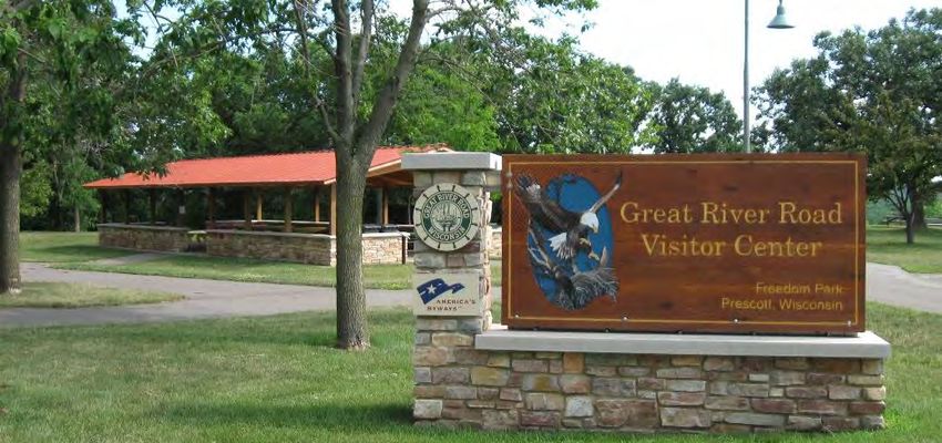
Vision Statement

The Citizens of Prescott recognize the inherent human and natural value of parks and other
recreational activities. With that realization, we commit to:

   •  Provide and manage park and recreational opportunities for a sustainable quality of
     life by balancing human needs and natural systems, ensuring the needs of present
     generations are met, without compromising the ability of future generations to meet
     their needs.
   • Promote the Riverfront recreational activities, as well as maintain the current park
     system in a healthy, safe, sustainable, and functional condition.
Table of Contents
                                                                                              Acknowledgements
Vision Statement

Chapter 1 ‐ Parks and Recreation                                                       3     Parks and Public Property
Introduction ......................................................................... 3     Committee
Types of Recreational Activities ........................................... 4               Bailey Ruona, Council, Chair
Benefits of Planning for Parks and Recreation ..................... 5                        Galen Seipel, Council
Goals and Objectives ............................................................ 6
                                                                                             Robert Daugherty, Council
Chapter 2 ‐ Community Profile .......................................... 9                   Jayne Brand, Administrator
Introduction ......................................................................... 9
Population Demographics .................................................... 9
                                                                                             Plan Commission
Population ............................................................................ 9
Age Distribution ................................................................... 10      David Hovel, Mayor, Chair
                                                                                             Robert Daugherty, Council
Chapter 3 ‐ Parks and Recreational Facility Standards ....... 12
                                                                                             Todd Dolan, Building Inspector
National Recreation and Parks Association Standards ......... 12
Parks and Open Space Classifications................................... 12                   Kyle Warp
Park Service Boundaries ....................................................... 15           Lother Nawrocki
                                                                                             Steve Eggers
Chapter 4 – Downtown‐Riverfront Planning ..................... 17
                                                                                             Connie Wenzel
Riverfront Unified Vision ...................................................... 17
                                                                                             Dan Finley
Chapter 5 – Existing and Proposed Sidewalks and Trails ... 23
Introduction ......................................................................... 23
Existing and Proposed Sidewalks.......................................... 23                 Common Council
Existing Bicycle Routes ......................................................... 25         David Hovel, Mayor
Proposed Coulee River Trails System ................................... 25                   Maureen Ottwel, 1st and 2nd Ward
Possible Trail Users .............................................................. 28
                                                                                             Galen Seipel, 3rd and 4th Ward

Chapter 6 ‐ Park and Recreational Inventory ..................... 29                         Joshua Gergen, 5th and 6th Ward
Parks and Recreation Facility Inventory ............................... 29                   Robert Daugherty, At Large
Freedom Park ....................................................................... 30      Darlyn Hintz, At Large
Jacques Park Public Boat Ramp ............................................ 31
                                                                                             Bailey Ruona, At Large
Lake Street Canoe and Kayak Launch ................................... 32
Magee Wilderness Park........................................................ 33             Jayne Brand, Administrator
Mercord Mill Park ................................................................ 34
Prescott City Beach .............................................................. 35
Public Square ....................................................................... 36
River Walk ............................................................................ 37

                                                                                                                     1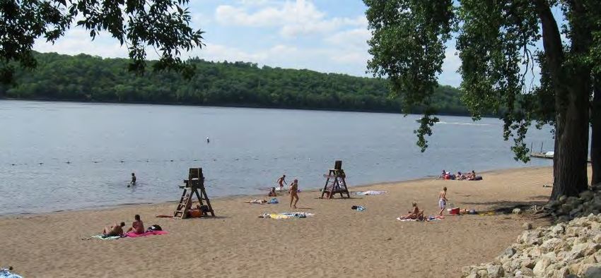
Shane Park Circle .................................................................. 38
Skate Park ............................................................................ 39
St. Croix Bluffs Neighborhood Park ...................................... 40                      Acknowledgement
Sunset Park .......................................................................... 41
Veteran Memorial Park ........................................................ 42
                                                                                                  Prescott City Hall
Chapter 7 – Other Park Related Improvements ................. 43                                  800 Borner Street
Standardizing Park Amenities............................................... 43
                                                                                                  Prescott, WI 54021
Naming of Parks and Recreational Areas ............................. 43
Park Signs ............................................................................. 45       www.prescottwi.org
Dedication of Trees and Bench............................................. 45
Chapter 8 ‐ Park Development and Land Acquisition ........ 46
Funding Sources ............................................................................ 46
Funding Programs.......................................................................... 46

Chapter 9 ‐ Plan Implementation ...................................... 51
5‐Year Capital Improvements Plan for Parks and Recreation ....... 51

Maps
Map 1: Existing Park and Recreation Facilities .............................. 1
Map 2: Park Classifications and Service Boundaries ..................... 16
Map 3: Proposed Downtown and Riverfront Improvements........ 19
Map 4: Proposed Downtown and Riverfront Improvements........ 20
Map 5: Proposed Downtown and Riverfront Improvements........ 21
Map 6: Proposed Downtown and Riverfront Improvements........ 22
Map 7: Existing and Proposed Sidewalks ...................................... 24
Map 8: Proposed Coulee River Trails ............................................ 27

Tables
Table 1: Historical Population: City of Prescott ............................ 9
Table 2: Projected Population: City of Prescott ........................... 10
Table 3: National Recreation and Parks Association Park
Classification System ..................................................................... 14
Table 4: Existing Park space: City of Prescott ................................ 15
Table 5: Park Improvement Priorities ........................................... 51               Planning Assistance
Figures                                                                                           Cedar Corporation
Figure 1: State of Wisconsin’s Goals for Outdoor Recreation ...... 8                              604 Wilson Avenue
Figure 2: Population Pyramid: City of Prescott ............................. 11
                                                                                                  Menomonie, Wisconsin 54751
                                                                                                  715‐235‐9081
                                                                                                  www.cedarcorp.com

                                                                                                                       2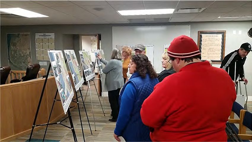
Chapter 1
Parks and Recreation
Introduction
The City of Prescott Comprehensive Outdoor Recreation Plan was created to analyze the
existing parks and recreation facilities and anticipate the recreational needs of residents
and visitors. The City of Prescott maintains a 5‐Year Comprehensive Outdoor Recreation
Plan to act as a guide for acquiring and developing local parks and recreation facilities
and coordinating with other agencies when opportunities arise.

Projected population and housing growth indicates additional park offering may be
needed in the future. This Plan inventories and evaluates existing parks, the service
areas and makes recommendations for improvements.

                                                             The City of Prescott is
                                      Prescott Wisconsin     located at the confluence of
                                                             the St. Croix River and
                                                             Mississippi River. It is
                                                             Wisconsin’s westernmost
                                                             incorporated community. It
                                                             is located on U.S. Highway
                                                             (U.S.H.) 10 and State Trunk
                                                             Highways (S.T.H.) 29 and 35
                                                             and is less than one half
                                                             hour drive from downtown
                                                             St. Paul, Minnesota.

                                                             The City of Prescott actively
                                                             promotes tourism with an
                                                             emphasis on the riverfront
                                                             and the confluence of the
                                                             two rivers.

S.T.H. 35 is designated as The Great River Road and is part of an international scenic
parkway from Canada to the Gulf of Mexico. The Wisconsin Great River Road has been
designated as a National Scenic Byway. National Scenic Byways are accepted into the
national system of scenic byways if they have at least one, out of six possible, intrinsic
qualities that elevates them to a nationally significant recognition. They must have
unique qualities that make them the “heart and soul” of the nation. Because of this,
Prescott gets thousands of visitors each year coming into the City for the first time.

                                                                                             3
Types of Recreational Activities
It is important to keep in mind that people have different parks and recreation needs
based on their age, physical ability, and activity they want to take part. Recreational
activities are classified as active or passive.
Active Recreation
Active recreation refers to activities for individuals or teams that require the use of
special facilities such as:
Basketball Courts
Baseball Diamonds
Soccer Fields
Golf Courses
Hockey Rinks
Tennis Courts
Skateboard Parks
Playground Equipment
Passive Recreation
Passive recreation refers to activities that do not typically require developed facilities
but place a priority on facilities or amenities that support the access to and enjoyment
of nature. These facilities and amenities include:
Walking, hiking and bicycling trails
Boat ramps or canoe/kayak launch areas
Observation decks
Docks
Beaches
Benches
Pavilions
Picnic tables
Restrooms
Drinking fountains
Bicycle racks
By providing a variety of recreational activities to the community, the City of Prescott
ensures that its parks are inclusive and accessible for users. At the same time,
communities must identify what parks, recreational facilities or natural features are
unique to them and can be used and promoted in a positive way.
4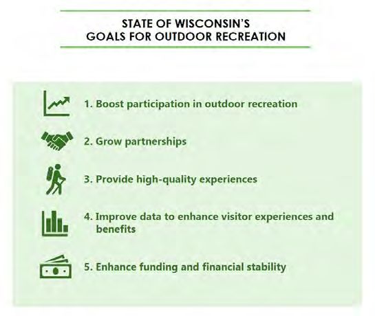
Benefits of Planning for Parks and Amenities
Parks and recreation are key for providing a quality of life to Prescott residents and
visitors. The specific benefits that park and recreation programs bring to a community
cover a wide spectrum and are important when promoting the City as a great place to
be.
Environmental Benefits
Natural areas provide wildlife habitat, improve surface water quality, provide
stormwater management, improve groundwater quality and improve air quality.
Trees and other vegetation provide shade, which reduces the urban heat island
effect.
Children and adults can experience and connect with nature and understand the
value of protecting the environment.
Health Benefits
Parks, trails, and recreation programs allow opportunities for people to engage
in physical activity at a level that fits their needs and abilities.
Children who are active at an early age tend to stay active as adults.
Exposure to nature can reduce stress and increase happiness.
Social Benefits
Parks and recreation programs are inclusive with regards to income, race, and
physical abilities.
Parks provide spaces for social interaction with friends or meeting new people.
These spaces provide places for concerts in the park, neighborhood picnics, and
farmers markets that bring people outdoors.
Parks can create a sense of pride and ownership in the community.
Economic Benefits
Quality parks can influence a person’s or business’ decision to stay in or move to
your community.
Property values tend to increase in relation to the proximity to parks.
Parks and recreation programs can generate income for local businesses when
park related events encourage people to stay overnight, go out to eat, rent
bicycles or kayaks, or stop at a convenience store.
5Goals and Objectives
The function of all plans, whether in our personal lives or in our community, is to
identify goals and achieve measurable objectives.
Goals are statements of desired outcomes or achievements. They are general in nature.
Objectives are more specific and identify measurable outcomes.
As a community’s desires and needs change, so too must its goals and objectives. The
following goals and objectives represent the ends to which the priorities and
recommendations in this plan are directed. These goals and objectives will provide a
sound basis for future planning decisions in the communities with regard to parks and
recreation.
City Wide
Goal 1: Create and maintain a safe park, recreation, pedestrian, and
bicycle network within the City of Prescott.
Objectives:
1. Increase opportunities for walking and biking as ways of experiencing one’s
neighborhood and community.
2. Promote the health benefits of walking and biking.
3. Provide safe routes for people to enjoy the City’s parks.
4. Provide safe routes for children walk and bicycle to school.
5. Maintain and expand existing sidewalk and trail system.
6. Review site plans to ensure sidewalk and trail connectivity.
7. Increase ADA accessibility to sidewalks, trails, and support facilities.
Goal 2: Provide handicapped accessible park facilities and varied
recreational opportunities to meet the needs of all park users.
Objectives:
1. Conduct an ADA Accessibility Audit of park facilities and amenities.
2. Incorporate a fully handicap accessible fishing dock/pier along the Riverfront.
3. Provide a variety of recreation opportunities for the disadvantaged, young,
old and handicapped.
4. Participate in federal and state financial aid programs to improve ADA
accessibility.
5. Provide safe access to parks and conservancy areas.
6Goal 3: Preserve and protect sensitive natural resource areas and
habitats.
Objectives:
1. Utilize and maintain environmental corridors and natural areas for passive
parks, trails, and educational purposes.
2. Preserve and protect surface waters, wetlands, shorelands, and floodplains
to maintain wildlife habitat.
3. Conserve, promote and provide access to natural areas.
4. Acquire additional parklands of environmental importance.
5. Utilize the variety of grant opportunities offered by the WDNR, Department
of Administration, and Department of Transportation to fund improvements
to park and recreational opportunities in the City.
6. Utilize public and private foundations and donations to fund parkland
acquisition, park amenities, or provide improved park and recreational
opportunities in the City.
Goal 4: Continue long‐range park planning and coordination with
individuals and groups.
Objectives:
1. Create a Park and Recreation Department within the City governmental
structure.
2. Develop a City government commitment for continued annual funding to
maintain all existing facilities in a manner conducive to the enjoyment and
safety of all using the facilities.
3. Develop and design plans for upgrade and development of all parks and
recreational lands according to specified standards.
4. Provide adequate signage for all parks and recreation areas.
5. Form partnerships between the City and volunteers and organizations for the
care and beautification of parks.
6. Optimize year round use of all recreational facilities available in the
community.
7. Coordinate the development of parks and the Coulee River Trails with Pierce
County, surrounding Towns, and other government agencies.
8. Review the Comprehensive Outdoor Recreation Plan and recommended
projects on an annual basis.
9. Work with developers to ensure parks, trails, and/or sidewalks are included in
development plans that are consistent with proposed improvements in the
Comprehensive Outdoor Recreation Plan.
7Riverfront Area
Goal 1: Improve the aesthetics and amenities along the Riverfront.
Objectives:
1. Work with private property owners to improve the appearance of their river
front buildings.
2. Acquisition and dedication of lands for adequate park and green spaces for
future population growth, with special priority being given to Mississippi
River Front lands south of the central business district to maintain or increase
public access to the River Front.
3. Implement the recommendations in the Unified Development for the
Riverfront.
4. Increase rental slip availability and public access and boat access of the
riverfront.
Freedom Park
Goal 1: Promote Freedom Park and the Great River Road Visitors and
Learning Center on a regional level.
Objectives:
1. Work with the Friends of Freedom Park on long‐range planning for the
maintenance and expansion of Freedom Park.
2. Support expanded programming at Freedom Park and the Learning Center.
Figure 1 State of Wisconsin’s Goals for Outdoor Recreation
Figure 1 shows the State of
Wisconsin’s Outdoor
Recreation goals. Many of
Prescott’s goals support the
State’s vision.
Source: WDNR SCORP 2019‐2023
8Chapter 2
Community Profile
Introduction
The City of Prescott is a growing community located on the confluence of the scenic St.
Croix and Mississippi Rivers. It is a beautiful, friendly community located in the western
most part of Pierce County, Wisconsin. The surrounding areas have an abundance of
wildlife, clean air, and a relaxed pace of life that residents and visitors enjoy.
The City of Prescott is accessible off S.T.H. 29 and 35 (The Great River Road) and U.S.H
10 which is a major east‐west highway corridor.
Prescott residents enjoy the small town feel they have been able to maintain while still
providing jobs and recreational opportunities to area residents.
Population Demographics
The State of Wisconsin Demographics Center and U.S. Census provide statistical data for
the population of all municipalities in the State of Wisconsin. The statistical data, or
demographics, for the City of Prescott may indicate trends related to population growth,
income, and age distribution that will be analyzed and considered when looking at
future park needs.
Population
In the 1850’s the City of Prescott Table 1: Historical Population: City of Prescott
was originally planned to be an Year 1970 1980 1990 2000 2010
immigrant city located on “the
Population 2,331 2,654 3,243 3,764 4,258
mouth of the St. Croix River.”
% Change ‐ 13.9% 22.2% 16.1% 13.1%
However, land speculation drove
Source: U.S. Census Bureau
up prices and many immigrants
settled further north, founding the Cities of Minneapolis and St. Paul.
Prescott’s location on the confluence of the St. Croix and Mississippi Rivers made it an
important shipping center. A steady supply of steamboats and the movement of lumber,
lead to the construction of hotels, warehouses, restaurants, banks, and numerous
homes within the City. Eventually trains replaced steamboats and the lumber resources
ran out which led to fewer settlers coming to Prescott.
In more recent times, Prescott’s proximity to the Twin Cities makes it home to
commuting professions. The City also draws a significant number of tourists due to its
9rustic character and historical significance. These factors have led to a sustained growth
in the City’s population over the last fifty years (see Table 1).
According to the 2013 report from the Wisconsin Demographic Services Center, the
trend of population growth is expected to continue over the next forty years, albeit,
much slower than it has in the past (see Table 2). As such, any actions taken on the
development of parks and designated recreation areas must take into consideration this
potential change of population.
Table 2: Projected Population: City of Prescott
Year 2010* 2018 est. 2020 2025 2030 2035 2040
Population 4,258 4,227 4,555 4,730 4,870 4,925 4,980
% Change ‐ ‐0.7% 7.8% 3.8% 3.0% 1.1% 1.1%
Source: *U.S. Census Bureau, Wisconsin Demographic Services Center 2013/12/10
Age Distribution
Recreation needs can vary depending on a person’s age. Identifying age groups and the
number of residents in those groups can help the City anticipate the types of facilities
needed in the future. Figure 1 shows the age distribution of Prescott residents by sex.
The figure shows fewer residents in the “30 to 44 years of age” group. The “Under 5 to
29 and 45 to 59 years of age” groups have the highest number of residents, but their
numbers are similar. This means that the population will be maintained at its current
numbers or grow slightly.
The median age of a Prescott resident is 39.7 compared to 36.0 for Pierce County
residents and 39.2 for a State of Wisconsin resident.
Age not only plays an important role in determining the types of recreational amenities
to provide, but also should be considered during the siting of parks. For instance, a
community may choose to locate smaller neighborhood parks closer to growth areas of
starter homes with young families. An aging population may require more passive type
parks.
10Figure 1: Population Pyramid: City of Prescott
CITY OF PRESCOTT AGE DISTRIBUTION: 2016
85 and over 7 53
80‐84 35 38
75‐79 19 38
70‐74 105 95
65‐69 109 98
60‐64 242 125
55‐59 93 168
50‐54 207 112
45‐49 79 108
AGE
40‐44 184 176
35‐39 121 168
30‐34 156 87
25‐29 135 87
20‐24 100 96
15‐19 158 134
9‐14 226 138
5‐9 168 87
Under 5 184 85
300 250 200 150 100 50 0 50 100 150 200
POPULATION
Male Female
Source: American Community Survey 2012‐2016
Poverty: The 2013‐2017 American Community Survey shows that 7% of all City of
Prescott residents lived below the poverty level compared to 10.7% of residents in
Pierce County. This may impact the ability to use fees as a way to pay for park
maintenance or expansion.
11Chapter 3
Parks and Recreational Facility Standards
National Recreation and Parks Association Standards
The National Recreation and Park Association (NRPA) provides guidelines for classifying
parks and open spaces. These are meant to act as a baseline to compare to help assess a
community’s offerings. The guidelines shown in Table 3 provide a description of each
classification, size of the park or open space and the area it serves. By mapping the
location, classification, and services areas of the City’s parks, gaps in service can be
identified and addressed in the Comprehensive Outdoor Recreation Plan. Map 1 shows
the locations of parks and open spaces in the City Prescott and their classifications.
Although the NRPA provides guidelines for parks and open space, the unique landscape
and development patterns of the community will influence the types of parks and
facilities that are offered. For Prescott, the St. Croix River, Mississippi River and Freedom
Park: The Great River Road Learning Center provide access to recreational opportunities
that many communities do not have.
Parks and Open Space Classifications
The National Recreation and Parks Association (NRPA) provides recommendations for
the types of parks and number of park acres per 1,000 residents that communities can
use for a baseline when evaluating parks and open space. The three (3) types of parks
and their recommended acreages are as follows:
Mini Park: 0.25 to 0.5 acres/1,000 residents
Neighborhood Park: 1.0 to 2.0 acres/1,000 residents
Community Park: 5.0 to 8.0 acres/1,000 residents
The three park classifications provide a range of 6.25 to 10.5 total acres of parkland per
1,000 residents. These three park classifications are generally considered the main
components of a park system. Other park classifications such as Large Urban Park,
Natural Resource Area, and Special Use Areas, are unique to each community,
therefore, recommended space needs are not provided for these park types.
12Existing Park &
Recreation Facilities
City of Prescott
15
16
23 16
12
11
1
17
10
7
18
8
14
4
2 19
20 9
3
21
5
22
LEGEND 6
1. PRESCOTT CITY BEACH
2. MERCORD MILL PARK
3. RIVER WALK
4. CITY COURTESY DOCK
5. JACQUES PARK PUBLIC BOAT RAMP
6. FREEDOM PARK 13
7. PUBLIC SQUARE
8. BELL PARK
9. MAGEE WILDERNESS PARK
10. SUNSET PARK
11. SHANNE PARK
12. SKATE PARK
13. VETERANS MEMORIAL PARK
N
14. WELCOME AND HERITAGE CENTER
15. ST. CROIX BLUFF PARK
16. SENIOR HIGH SCHOOL
17. MALONE ELEMENTARY SCHOOL
18. SCHOOL DISTRICT BASEBALL FIELD
19. ST. JOSEPH SCHOOL
20. LEO'S LANDING
21. POINT ST. CROIX MARINA
22. MISS-CROIX YACHT HARBOR
23. LAKE ST. CANOE/KAYAK LAUNCH
Map 1Table 3: National Recreation and Parks Association Park Classification System
Mini‐Park
Description: Mini‐Parks serve a concentrated population or specific age group or function but can serve persons of all ages
located in the immediate area. They typically contain children's playground equipment and passive amenities such as
benches and shelters.
Service Area: Less than 1/4 mile radius
Recommended Size: 1 acre of less
Acres/1,000 Residents: 0.25 to 0.5 acres
Neighborhood Park
Description: Neighborhood Parks are the foundation of the park system and serve as the recreational and social focus of
the neighborhood. These parks serve residents in a variety of age groups. The park should be easily accessible and access
should be uninterrupted by major roads or other barriers. Parking may be neccessary.
Service Area: 1/4 mile to 1/2 mile radius
Recommended Size: 5 to 10 acres
Acres/1,000 Residents: 1.0 to 2.0 acres
Community Park
Description: Community Parks are diverse in nature and serve a broader purpose than the neighborhood or mini parks. They
are larger than neighborhood parks and are intended to serve a larger area. Community parks usually have both day and
evening activities. Community parks include a mix of active and passive activities and attract users of all ages.
Service Area: 1/2 mile to 3.0 mile radius
Recommended Size: More than 10 acres
Acres/1,000 Residents: 5.0 to 8.0 acres
Large Urban Park
Description: Large Urban Parks serve a broader purpose than community parks and are used when community and
neighborhood parks are not adequate to serve the needs of the community. Focus is on meeting community based
recreational needs, such as a soccer complex, as well as preserving unique landscapes and open spaces.
Service Area: Community‐wide
Recommended Size: 50 acres or more
Acres/1,000 Residents: N/A
Natural Resource Areas
Description: Lands set aside for preservation of significant natural resources, remnant landscapes, open space and visual
aesthetics/buffering.
Service Area: Varies
Recommended Size: N/A
Acres/1,000 Residents: N/A
Special Use Parks or Areas
Description: Special Use Parks include specialized recreational activities that are often unique to a community. Activities
can include boat ramps, campgrounds, golf courses or beaches. These parks usually provide amenities that serve the entire
community as well as visitors from beyond the district and are typically a single use park.
Service Area: Varies
Recommended Size: N/A
Acres/1,000 Residents: N/A
School Parks and Facilities
Description: School Parks and Facilities can fulfill the space requirements for other classes of parks such as neighborhood,
community, sports complex, and special use parks. Access to these facilities may be limited during school hours.
Service Area: Varies
Recommended Size: N/A
Acres/1,000 Residents: N/A
Source: National Recreation and Parks Association
14Table 4 shows recommended acreages for mini‐parks, neighborhood parks and
community parks based on the City of Prescott’s estimated 2010 population.
Table 4: Existing Park Space: City of Prescott
Park Type *Recommended Acreage Actual Acreage
Mini‐Park 1.06 to 2.13 0.15
Neighborhood Park 4.26 to 8.52 4.7
Community Park 21.29 to 34.06 2.5
Source: National Recreation and Park Association.
*Recommended acreages are based on the 2010 U.S. Census estimated population of 4,258 residents.
The City of Prescott falls short of recommended acreages for Mini‐Parks and Community
Parks but meets the recommended acreage for Neighborhood Parks. It should be noted
that because of the extensive public land along the St. Croix River and Mississippi River
and topography within the City, Prescott has a high amount of Specialty Parks that are
available to the public.
Park Service Boundaries
The National Recreation and Parks Association (NRPA) provides recommendations for
the area served by community parks, neighborhood parks, and mini‐parks. The three (3)
types of parks and their recommended service areas include:
Community Parks: 0.5 to 3 mile service radius
Neighborhood Parks: 0.25 to 0.5 mile service radius
Mini‐Parks: up to 0.25 mile service radius
Map 2 shows the Park Service Boundaries of the tot lots, neighborhood parks and
community parks in the City of Prescott. Most residential neighborhoods have access to
some kind of park facilities in the City.
15Park Classifications &
Service Boundaries
City of Prescott
15
16
23 16
12
11
1
17
10
7
18
8
14
4
2 19
20 9
3
21
5
22
LEGEND 6
1. PRESCOTT CITY BEACH
2. MERCORD MILL PARK
3. RIVER WALK
4. CITY COURTESY DOCK
5. JACQUES PARK PUBLIC BOAT RAMP
6. FREEDOM PARK 13
7. PUBLIC SQUARE
8. BELL PARK
9. MAGEE WILDERNESS PARK COMMUNITY PARK
10. SUNSET PARK NEIGHBORHOOD PARK
11. SHANNE PARK TOT LOT
12. SKATE PARK SPECIALTY PARK
13. VETERANS MEMORIAL PARK SCHOOL PARK
N
14. WELCOME AND HERITAGE CENTER
15. ST. CROIX BLUFF PARK
16. SENIOR HIGH SCHOOL 2 MILE SERVICE BOUNDARY - COMMUNITY PARK
17. MALONE ELEMENTARY SCHOOL
18. SCHOOL DISTRICT BASEBALL FIELD 1/2 MILE SERVICE BOUNDARY - NEIGHBORHOOD PARK
19. ST. JOSEPH SCHOOL
20. LEO'S LANDING 1/4 MILE SERVICE BOUNDARY - TOT LOT
21. POINT ST. CROIX MARINA
22. MISS-CROIX YACHT HARBOR
23. LAKE ST. CANOE/KAYAK LAUNCH
Map 2Chapter 4
Downtown-Riverfront Planning
Riverfront Unified Vision
In the fall of 2018, the City of Prescott and Prescott Park and Public Property Committee
explored ideas to improve the riverfront experience for residents and visitors while
connecting the riverfront safely with the downtown and Freedom Park.
The Park and Public Property Committee conducted an on‐site visit of the downtown‐
riverfront area to create a list of suggested improvements to build a unified vision that is
aesthetically pleasing, safe, and makes Prescott a destination whether on boat, driving
through the community, or bicycling along the Great River Road.
Proposed Riverfront Improvements Open House
An Open House was held, and the public was invited to review the proposed
improvements. Each person was given five stickers to place on the displays next to the
proposed improvements the wanted to see completed first.
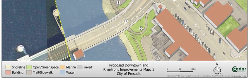
17Maps 3, 4, 5 and 6 show the displays that were presented to the public. Approximately
30 residents attended the open house. The proposed improvements, in order as they
appeared on the displays, and the total votes are shown below.
1. Replace Stairs 19 votes
2. Improve Bridge Abutment 8 votes
3. Improve Aesthetics 3 votes
4. Walking Path to the Dock and Extend Green Space 11 votes
5. Replace Stairs and Dock 12 votes
6. Screen Parking Lot and Traffic Calming 6 votes
7. Improve Emergency Access 7 votes
8. Construct Parking and Sidewalk 8 votes
9. Repurpose Gear House 1 votes
10. Remove Deck Platform 0 votes
11. Create a Master Plan for Space 2 votes
12. Screen Lift Station 0 votes
13. Improve Aesthetics 3 votes
14. Install New Dock and Transient Slip 11 votes
15. Construct Trail to Freedom Park 17 votes
16. Improve Access from Main Street to Front Street 6 votes
Based on the voting results and community feedback the following improvements were
identified as the top priorities:
1. Replace stairs under bridge with… 19 Votes
2. Construct trail to Freedom Park 17 Votes
3. Replace stairs, ramp and dock 12 Votes
4. Walking path to dock, extend green space 11 Votes
5. Install new dock and transient slip 11 Votes
18With Something Like These.
1
Replace This...
2
Replace This...
With Something Like This
3
Beautify Bridge Repairs and Railing.
Or This.4
5 Add Retaining Walls to Increase
Replace Dock Access
Greenspace/Usable Space
6
Add Screening and Traffic Calming
8
Add Sidewalk, Parking
and Safety Fence7
Improve Emergency and
Pedestrian Access
16
Improve Downtown/Riverfront Connections
9 10
Remove or Improve
Repurpose Gear House? Observation Area14
Add New Dock to Existing Ramp.
11
Vision For Future Use.
15
Build Scenic Bicycle/Pedestrian
Trail to Freedom Park.
12 13
Screen Lift Station Improve Aesthetics
and Improve Parking Area. At Boat Landing.Chapter 5
Existing and Proposed Sidewalks and
Trails
Introduction
Trails are always part of a Comprehensive Outdoor Recreation Plan, but sidewalks are
rarely included. It is reasonable to discuss sidewalks in the City’s Comprehensive
Outdoor Recreation Plan because sidewalks provide safe places to walk in an urban
environment and allow people to walk for exercise close to home. By providing safe
sidewalks in a community, people of all ages and physical abilities can enjoy their
neighborhood and the outdoors.
Existing and Proposed Sidewalks
Map 7 shows the location of existing and proposed sidewalks in the City of Prescott.
Most existing sidewalks are located in the central business district and riverfront area
adjacent to the St. Croix River, neighborhoods near schools, and in more recent
developments north of U.S.H. 10. The existing sidewalks have gaps between them
where residents have to walk in the street when going from home to their destination.
The proposed sidewalk network closes those gaps where sidewalks do not exist with the
goal of providing a continuous sidewalk network. This allows residents to safely get to
most parts of the City by sidewalk and also allows safe access to local stores and
institutions such as schools, the library, commercial/retail businesses, workplaces, City
Hall, and parks.
Because three major state and U.S. highways serve the City of Prescott, these areas can
be challenging to cross. In the downtown area, lower speeds and crosswalks help
people cross S.T.H. 35. In the northern portion of the City, where S.T.H. 29, S.T.H. 35,
and U.S.H. 10 intersect, crossing these highways can be dangerous because of the width
of the roadway, speeds, and higher traffic counts.
In this area, an underpass would allow safe passage of pedestrians and bicyclists under
U.S.H. 10. It is anticipated that a minimum of two underpasses would be needed to
provide full accessibility to this area of the City. Map 7 identifies four proposed
underpass locations. A description of each is as follows.
Location 1: This underpass would connect the main portion of the City and northwest
portion of Prescott at the intersection of U.S.H. 10 and Canton Street. It would connect
to existing sidewalks that serve commercial and residential areas. This location is
23Existing &
Proposed Sidewalks
ver
City of Prescott
oix Ri
St. Cr
5 3
H.
.T.
/S
29
.
.H
6,300
S.T
4
Canton St.
2 4,600
1 3 U.S.H. 10
S.T.H. 35
10 Orrin Rd.
S.H.
U.
Borner Street
High School
Pearl St.
Intermediate
Dexter St.
School
St. Croix St.
10,500
Elementary
School
. Walnut St.
c St
ni
in
i ck
nn
Ki
15,300 Middle
School
El
m
St
.
Monroe St.
S.T.H. 35
Mi
ssis
sip
pi R
i ver Map 7
LEGEND N
Existing Sidewalks
Proposed Sidewalks
Proposed Underpass
4 Corresponds to Text in the Plan
6,300 Average Annual Daily Traffic
Source: AADT 2018 WISDOTalready used as a main crossing point in the City. There is adequate space to transition
to a future underpass.
Location 2: This underpass would connect the northwest portion of the City and the
northeast portion of the City. Sidewalks would have to be constructed in the northeast
portion. Challenges to this location are a proposed future roundabout at the
intersection where the three highways meet and existing stormwater infrastructure.
Location 3: This underpass would connect the main portion of the City and northeast
portion of Prescott at Eagle Ridge Road. The underpass would require additional
sidewalks to be constructed on the south side of U.S.H. 10. U.S.H. 10 is narrower in this
location and transition areas to an underpass are adequate.
Location 4: This underpass would connect the northeast portion of the City and north
portion of Prescott at Eagle Ridge Road and North Acres Road. This location would
provide access to the grocery store, industrial park, commercial, and residential areas
and sidewalks would have to be extended on the south side of U.S.H. 10.
Existing Bicycle Routes
The Great River Road (S.T.H. 35) is a popular route for bicycling and brings people from
out of town into the community who want to explore area bicycling opportunities. The
ability to attract these bicyclists can provide a boost to the local economy if a
community’s bicycle infrastructure provides bicycle workstations, parking infrastructure,
outdoor restrooms, safe trails, and accessible water. Bike lanes are painted on STH 35
to accommodate bicyclists.
There is an opportunity to connect to multi‐use trails in Minnesota. The Point Douglas
Regional Trail is a walking and bicycling trail in Minnesota that links the City of Hastings with
the City of Prescott. This portion of the Minnesota trail is expected to attract 150,000 users a
year. The Trail connects to a walkway on the St. Croix River Bridge that takes users to
downtown Prescott. The trail provides a great opportunity for existing and future downtown
businesses in Prescott. It also provides a great opportunity work cooperatively with
Minnesota, Pierce County, and the surrounding Towns to connect to the Point Douglas
Regional Trail. There are no specific bike trails in the City of Prescott, but bicycling is allowed
on all City streets.
Proposed Coulee River Trails System
The City of Prescott is a part of a group of stakeholders who are planning an extensive
trail network named the Coulee River Trails System (CRTS). The CRTS begins in the City
of Prescott and extends into the surrounding area. The stakeholder group consists of
members of Freedom Park, the City of Prescott, Pierce County, Prescott School District,
National Park Service, WDOT, property owners, and others who are working on
25identifying trail locations, funding, and agreements with local landowners to develop a
trail network.
Map 8 shows the proposed CRTS. The lines on this map indicate trail desire lines: areas
where non‐motorized trails or paths are desired for recreation and/or non‐motorized
transportation. They do not indicate exact future trail alignments. Trail alignments will
be determined through phased planning and design processes that will involve public
input. These trail desire lines indicate the major trail corridors that form the planned
hard surface loop system. It is intended that, where feasible, a variety of shorter looped
trails will be developed that lead from the main trail at recreational nodes that are
available to the public, such as at Magee Park. These shorter loops are not shown on
the map and will only be added when feasible.
The Coulee River Trail System intends to:
Include a large loop system that connects the City of Prescott to other natural
and recreational lands in Pierce County.
Include a variety of trail types, from hard surface trails that meet Americans with
Disabilities Act guidelines to narrow natural surface trails for mountain biking
and/or hiking.
Connect new and developing neighborhood residential areas to the trail system
by obtaining trail connection corridors, where feasible, through the platting
process.
Connect existing residential and commercial areas to the trail system by utilizing
existing public corridors or negotiating with landowners for purchase of land or
easements for a trail corridor.
Connect to destinations within Prescott and vicinity, such as scenic highlights,
the high school, downtown, etc.
Connect to the existing or future sidewalk system, bike lanes or other non‐
motorized transportation or recreation facilities.
Connect to future regional or state trails in the vicinity, when feasible.
When possible, develop trail corridors away from road rights of way in more
natural areas. First consider corridors already in public ownership/easement. If
these are not sufficient, then the purchase of land or an easement for a trail
corridor from willing sellers can be considered. This often involves purchasing
property from a number of different landowners. To accomplish this, trail
developers must remain flexible in their selection of a trail alignment in order to
piece together a corridor from willing sellers. This is a slow and sometimes
difficult process, but, when successful, can be well worth the effort to provide a
scenic and sometimes spectacular experience for trail users.
Consider trail design needs prior to determining the final trail alignment. The
planning team will consult the WisDOT Bicycle Facility Design Handbook, the
AASHTO Guide for the Development of Bicycle Facilities, the International
Mountain Biking Association’s trail planning & design books, the USDOT’s
26Designing Sidewalks & Trails for Access and other relevant trail design guides for
design recommendations. State and federal design guidelines must usually be
met if using state or federal funding.
Possible trail corridors include:
road rights‐of‐way
abandoned railroad corridors
“paper” roads in public ownership but never developed
former public roads no longer in use
utility corridors
along the edge of stream, ditch or wetland buffers
along property lines
along edges of agricultural fields
land no longer in cultivation
other scenic corridors purchased for trails
Possible Trail Uses
Trails in the Coulee River Trail System will be designed to accommodate a variety of
uses. Some trails may prohibit specific uses. The trail system may include areas
for: bicycling, mountain bicycling, hiking and walking, cross‐country skiing, dog walking,
running/jogging, in‐line skating/skate skiing, and cross‐country skiing and environmental
education / interpretation. Snowmobiling, horseback riding, hunting (except where
regulated by community ordinance) may be considered for some areas.
When the Coulee River Trails System is finalized, it will be used to ensure trails are
incorporated in new development to begin growing the CRTS. It is likely that some of the
trails will be completed in areas where no development is anticipated at this time. The
proposed CRTS will have a major impact on recreational offerings in the region and
could become an area and regional attraction.
27Borner Stree
High School
Proposed Coulee River Trails System
U.S.H. 10
Intermediate
. -..~_,r--
, '
Preliminary Planning Stages
School \
\
\\
\
' \
\ City of Prescott/Town of Oak Grove
\ \ \
\ \ \
'
I \\ '
I
Elementary
School
'I
I
I
I
...., '
\
\
:
I
\ \ I
\ \:
Middle I
. -·-- I
\ I
, , .~ .............
1--
1 ......
School
I \ I
I
.
, _.., __,,
I ....
--"--)- I
I
I .. "'\
,
,,. ......, II
\
'I
I
,,' ,,,. \
\
I
I
_
\ I
' _____ __ ..
,.. .._ __ .,..I
.
t/1,-~~
--,,.. -----"
,
S.T.H. 35
Map 8
N
LEGEND
City Boundary
S.T
.H
Proposed Trails .3
5Chapter 6
Parks and Recreation Inventory
Parks and Recreational Facility Inventory
Cedar Corporation and City staff conducted an inventory of the existing park and
recreation facilities available within the City. Creating a park inventory is the first step in
determining the future recreational needs of the City. Cataloging parks and recreational
resources not only shows what is available to a community but may also reveal a need
for equipment maintenance, ADA accessibility improvements, or for new amenities not
currently offered in the community.
A description of each park and recreation facility within the City of Prescott is provided
and includes the amenities, location, size, and jurisdiction of each resource. Parks under
the jurisdiction of the city include expanded detail pages, which list out the use, current
amenities, and planned improvements for each park.
Recommended improvements for each park are listed beginning on the next page.
Some of the recommendations have a timeframe of To Be Determined (TBD). This
means that the proposed improvement is dependent on other factors such as the
availability of land or grant programs that can be used to offset costs.
29Freedom Park
Park Type: Community Park Size: 2.5 Acres
Jurisdiction: City
Site Image Map
Park Description
Freedom Park is located on the bluffs above the Mississippi River Valley at the
intersection of Jefferson Street and Monroe Street. This public access site offers
amenities for a wide range of passive activities for all age groups of users.
Amenities Inventory
Playground Structures One standing binocular station
19 picnic tables One handicap accessible binocular
Gardens station
10 information kiosks Drinking fountain
Walking paths Amphitheater
Picnic shelter Bike rack
Pavilion Swing set
8 benches Lawn irrigation
4 public grills Location of the GRR Learning
Center
Programing
Passive recreation
Recommendations Timeframe
Work with the Friends of Ongoing
Freedom Park on long‐range
planning for the Center.
30Jacques Park Public Boat Ramp
Park Type: Specialty Park Size: 1 Acre
Jurisdiction: City
Site Image Map
Park Description
The Jacques Boat Ramp is a public point of entry for the Mississippi River and is
predominantly used by recreational boaters and fisherman. This boat launch is
located on the southern end of Ash Street.
Amenities Inventory
Boat launch ramp Vehicle and boat parking
Docks Trash receptacles
Programing
N/A
Recommendations Timeframe
Improved Signage 1‐5 years
31Lake Street Canoe & Kayak Launch
Park Type: Specialty Park Size: 0.5 Acres
Jurisdiction: City
Site Image Map
Park Description
This park is located along the St. Croix River at the North end of Lake Street North. It is
primarily used as a foot access point for launching canoes, kayaks and other small
watercrafts. A staircase offers an easy descent to the waterfront.
Amenities Inventory
On‐street parking Picnic area
Benches Small craft boat launch
River access
Programing
Passive recreation
Recommendations Timeframe
Replace information sign 1‐5 years
Expand parking areas 5‐10 years
32Magee Wilderness Park
Park Type: Specialty Park Size: 13 Acres
Jurisdiction: City
Site Image Map
Park Description
The Magee Wilderness Park is accessible only by foot. This area is predominately
undeveloped wood and brush land used as a hiking and wildlife observation area.
Several amenities are offed such as picnic benches.
Amenities Inventory
Hiking Trails Picnic Benches
Wildlife Observation
Programing
N/A
Recommendations Timeframe
Signs 5‐10 years
New picnic shelter 5‐10 years
Solar park lighting 5‐10 years
Multipurpose trail with 5‐10 years
connections to future parks and
trails 5‐10 years
Dog park 5‐10 years
Trail from High School
33Mercord Mill Park
Park Type: Specialty Park Size: 4 Acres
Jurisdiction: City
Site Image Map
Park Description
This park has a picnic shelter, flagpole, six benches, four picnic tables, grills, and a
public fishing dock. The historic railroad bridge “gear house is open for viewing on
weekdays.
Amenities Inventory
Boat launch ramp Vehicle and boat parking
Docks Trash receptacles
Programing
N/A
Recommendations Timeframe
Signage from Main Street TBD
New restrooms TBD
Connections to Point Douglas TBD
Trail TBD
Signage to and from other trail
systems
34Prescott City Beach
Park Type: Specialty Park Size: 1 Acre
Jurisdiction: City
Site Image Map
Park Description
This beach side park offers plenty of space for all age group uses to use for activities
such as swimming and picnicking. It is located along the St. Croix River, off Lake Street
north of the US Highway 10 bridge.
Amenities Inventory
Bathhouse/changing area Picnic areas
Beach house Bicycle rack
Restrooms Sand beach
Parking area
Programing
Swimming lessons
Recommendations Timeframe
Add additional green space/picnic 5‐10 years
area at the north end of the park
New fencing along rip‐rap 5‐10 years
Restripe parking area 5‐10 years
Update signage from street 5‐10 years
Upgrade site with an ADA 5‐10 years
accessible ramp
35Public Square
Park Type: Neighborhood Park Size: 2 Acres
Jurisdiction: City
Site Image Map
Park Description
Active and passive recreation activities for all age groups are available at this park.
Prescott Lions Club helps with the majority of funding and equipment improvements.
Amenities Inventory
Two tennis courts Two bicycle racks
Two basketball hoops and court Benches
Playground structures Picnic shelter
Drinking fountain
Programing
N/A
Recommendations Timeframe
Revamp lawn area 1‐5 years
New sand and nets in volleyball 1‐5 years
court 1‐5 years
New fence around tennis court 1‐5 years
Maintenance to basketball court 1‐5 years
Park lighting
36River Walk
Park Type: Specialty Park Length: 2,000 feet
Jurisdiction: City
Site Image Map
Park Description
The River Walk connects bicycle/walking trails together and passes through Mercord
Mill Park. It features an information kiosk, benches, and picnic tables.
Amenities Inventory
Information kiosk Bicycle/walking trail
benches Picnic tables
Programing
N/A
Recommendations Timeframe
Widen Sidewalk TBD
Restore shoreline TBD
Explore options for additional TBD
docks TBD
Signage from streets
37Shane Park Circle
Park Type: Mini‐Park Size: 0.15 Acres
Jurisdiction: City
Site Image Map
Park Description
This park is located in the center of the large cul‐de‐sac at the end of Shane Park Circle
Road. A geodesic dome play structure, two picnic tables, two trash receptacles, one
bench, multiple swings, and a child’s super‐scoop are present at this park.
Amenities Inventory
Geodesic dome play structure One bench
Two picnic tables A children’s super‐scoop
Two trash receptacles Swing set
Programing
N/A
Recommendations Timeframe
New sign 1‐5 years
Shade trees 1‐5 years
38Skate Park
Park Type: Specialty Park Size: 0.7 Acres
Jurisdiction: City
Site Image Map
Park Description
This skate park is located south of Pine Street and West of Dexter Street. The typical
users for this park are school‐age children and teenagers.
Amenities Inventory
Multiple ramps Sign
Half pipe Two trash receptacles
Rail Picnic table
Programing
N/A
Recommendations Timeframe
Graffiti removal 1‐5 years
Ramp maintenance 1‐5 years
39St. Croix Bluffs Neighborhood Park
Park Type: Neighborhood Park Size: 2.3 Acres
Jurisdiction: City
Site Image Map
Park Description
This park is located at Pearl and Canton street and features playground structures,
swings, basketball court and several other recreation opportunities for children. This
park is popular with a nearby daycare.
Amenities Inventory
Playground structures Picnic tables and benches
Multiple swing sets Basketball court
Geodesic dome play structure Soccer/multipurpose field
Picnic shelter
Programing
N/A
Recommendations Timeframe
Connection to other City TBD
sidewalks and trails
Fairy Garden TBD
40Sunset Park
Park Type: Neighborhood Park Size: 0.4 Acres
Jurisdiction: City
Site Image Map
Park Description
Children are the primary users of this smaller neighborhood park. The park is located
off Tower Road in the Eastern side of Prescott.
Amenities Inventory
Benches Sand box
Bench swing Swing set
Two trash receptacles Slide
Two picnic tables Playground structure
Half basketball court
Programing
N/A
Recommendations Timeframe
Remove or replace sandbox 1‐5 years
Pavilion TBD
Grills TBD
Replace metal slide with plastic TBD
41Veteran Memorial Park
Park Type: Specialty Park Size: 0.5 Acres
Jurisdiction: City
Site Image Map
Park Description
The Veteran Memorial Park is located on the Southern end of the City just off Monroe
Street. Adults and veterans are the primary users of this park. Park improvements are
typically completed by local veterans.
Amenities Inventory
Veterans memorial marker stones Flagpole
Five decorative benches
Programing
N/A
Recommendations Timeframe
Park sign TBD
Solar park lighting TBD
42Chapter 7
Other Park Related Improvements
Standardizing Park Amenities
The development of standards for park amenities will create a uniform design for the
City and its parks. The uniformity will create recognition of parks and parklands,
attracting more people to the park simply due to the ease of identification. The
following items should be considered for standardization:
Shelters
Trash receptacles
Signs
Benches
Picnic tables
Naming of Parks and Recreational Areas
While the naming of City Parks and Recreational Areas will ultimately be the decision of
the City Council, if requested, the following guidelines will be used in making a
recommendation to the City Council.
The purpose of this policy is to provide a consistent method for naming or making name
changes to public parks, public land, or recreation facilities. Names should identify
significant historical, geological, and ecological areas located within the City. In
addition, appropriate recognition to individuals who have contributed to the growth and
development of the City should be considered.
Goals and Objectives for naming:
The names must be purposeful, suitable, symbolic, uncontroversial and must fall
under one of the classifications of this policy.
If possible, names of facilities should be adopted before dedication or
development begins for a new facility.
Names will not be for living persons except when substantial donations are
offered to the community for park and recreation purposes.
Names for public officials will not be used without thorough justification. It will
be necessary for this individual to have strong community support.
43Classifications in order of priority:
1. Places and Features
Natural phenomenon
Recognizable area or neighborhood
Descriptive
Horticultural
Assumed name
2. Historic Events
Battles
Discoveries
Explorations
Community Development
3. Organizations
Civic
Veterans
Fraternal
Other
4. Persons Name
Large donors
Historical groups
Local war heroes
National war heroes
National officials
State officials
Local official
Local individual
5. Great Ideas or Causes
Ecological
Friendship
Independence
Peace
44City of Prescott Comprehensive Outdoor Recreation Plan 2019 to 2024
A group may ask to adopt a park or recreation facility for improvement or maintenance
purposes, and in return, the park or facility could be named after that group. A written
agreement should be signed specifically detailing the future responsibilities of the group
adopting the park or facility and any name change must first be approved by the City Council.
It may be appropriate in some cases to name subsections of parks to honor or pay tribute. This
shall include ball fields and areas. Naming shall follow the above procedures.
Plaques and markers shall be used to recognize individuals that contributed to the growth and
development of areas and facilities as project budgets allow. These markers shall be approved
by the City Council before installation.
Park Signs
Park signs identifying the facility to the public should be posted at all entrances. Signage will
promote civic pride and will encourage visitors.
Park signs should be standardized in order to make them easily identifiable to residents and
visitors. New park signs should incorporate three elements in their design:
A logo for City parks.
The name of each park.
Park hours.
Adding park hours would eliminate the need for many smaller signs that can be found in some
parks.
Dedication of Trees and Benches
Residents may want to dedicate trees or benches on behalf of a family, organization, business,
or in memory of a loved one. The City will provide a list of specific trees and bench styles that
can be donated to the park of the donor’s choice. The tree or bench will have a plaque to
identify the donor.
Example Tree Dedication Marker Example Bench Dedication
45City of Prescott Comprehensive Outdoor Recreation Plan 2019 to 2024
Chapter 8
Park Development and Land Acquisition
Funding Sources
Often grants or other outside funding sources are required to implement projects to minimize
the cost of land acquisition, park maintenance and new amenities or facilities to the
community. Grants are available through several state and federal agencies to help offset the
cost of park and recreation related projects. There are also non‐governmental agencies and
organizations that can help.
Assistance can be in the form of a grant, donation, or in‐kind services. Many grants have
specific time deadlines and require matching funds from the community. The most commonly
used programs for park, bicycle, and pedestrian infrastructure are the Wisconsin Department of
Natural Resources Knowles‐Nelson Stewardship Program. These programs are listed below as
well as other programs through other agencies.
The list below provides options the City may explore when researching funding opportunities
for park and recreation related projects. Program parameters and deadlines may change from
year to year.
Funding Programs
Most communities search for outside funding sources to offset the cost of park maintenance, land
acquisition, new amenities or trails. The Wisconsin Department of Natural Resources administers a
wide variety of grants that are available to local governments, tribes, conservation groups, and
landowners.
Acquisition & Development of Local Parks
Eligibility & Purpose: Helps to buy land or easements and develop or renovate local park and
recreation area facilities for nature‐based outdoor recreation purposes (e.g., trails, fishing access and
park support facilities). Applicants compete for funds on a regional basis. This grant program is part
of the Knowles‐Nelson Stewardship Program.
ATV Enhancement
Eligibility & Purpose: Annual funding to a non‐profit organization that promotes the safe and wise
use of ATVs and UTVs, ATV/UTV riding and ATV/UTV education.
ATV Patrols
Eligibility & Purpose: Issued to Wisconsin county sheriff departments that participate in ATV
enforcement efforts.
46You can also read