High-accuracy Indoor Positioning Project - EU-Japan Centre ...
←
→
Page content transcription
If your browser does not render page correctly, please read the page content below
High-accuracy Indoor Positioning Project
                     - Providing assistance for everyone
                       to avoid stress to travel

                             March 7th, 2017
                              Naoya AOTO
             Director, National Land Information Division,
         National Spatial Planning and Regional Policy Bureau

Ministry of Land, Infrastructure, Transport and Tourism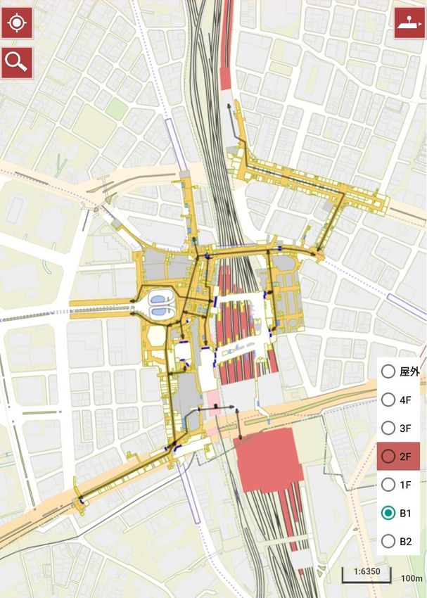
Purpose: Toward the success of the Olympic Games
Welcome visitors to Tokyo with most advanced,
best-in-class services in the world
To hold the 2020 Tokyo Olympic and Paralympic Games
smoothly and to broaden these services to the whole of Japan
as the Legacy.
【Transportation】
To make a smooth movement
- In Tokyo, the public transportation and the stations (terminals)
have very highly-dense network/structures.
- Most visitors have to take the public transportation
Four railroads enter Shibuya Station,
to go to each Olympic/Paralympic venue. and it is a complex structure of eight
layers including ground and
【Safe and Secure】 underground. (Tokyo Metro web site)
To evacuate smoothly and properly in case of
a large-scale disaster.
【Sightseeing】
To make a enjoyable tourism with easy-to-follow guidance
Shinjuku Station after2
in multiple languages instead of the way “signboard” only. the Great East Japan
Earthquake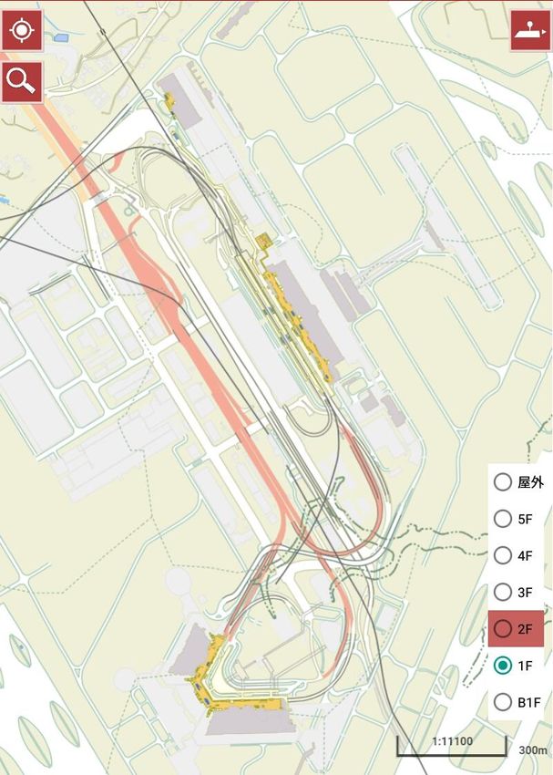
Background: Present status of outdoor positioning
Currently, various services using GNSS provides outdoor location
information with the accuracy of one to several meters.
In Japan, the development and operation of Quasi-Zenith
Satellites System are currently in progress.
The Quasi-Zenith Satellites will be able to realize highly accurate
positioning by complementing and improving GPS positioning.
           We should consider :
           • to develop/confirm the seamless positioning
             thorough outdoor and indoor.
        Examples of services using GNSS                            Quasi-Zenith Satellite
                                                  GPS

                                                                      Improved
                                                        Only GPS      positioning
  Car navigation system   Direction application
                             for smartphone                                                 3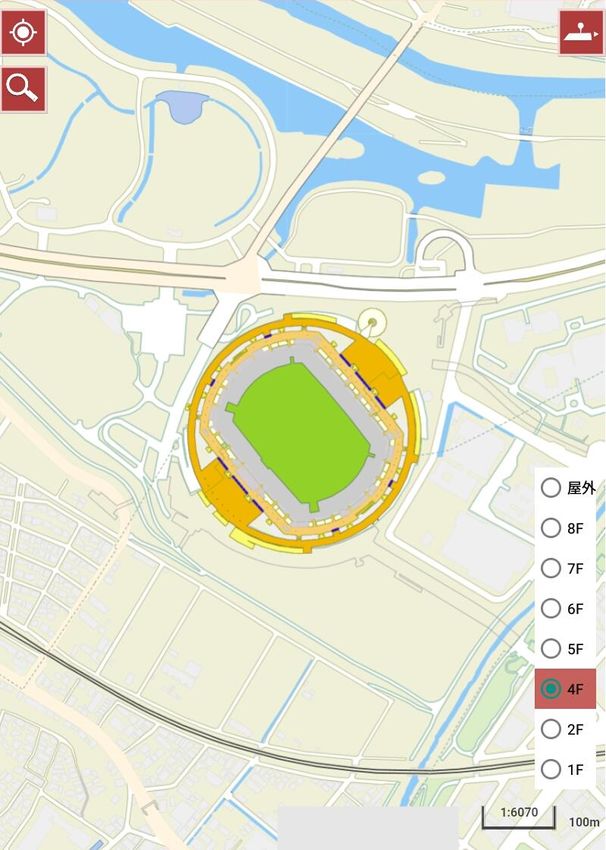
Background: Present status of indoor positioning

   The signal transmitted by the GNSS does not reach indoor.
            ?
                           ?

 A wide variety of technologies and methods for estimating
 indoor position is being developed.
 We should consider:
  • to verify availability of these method and to make guidelines
    for installing/setting indoor positioning instrument.
                       Examples of indoor positioning methods

                                                                                       4
    Wireless LAN (Wi-Fi)        Bluetooth (beacon)      Inaudible sound (sound wave)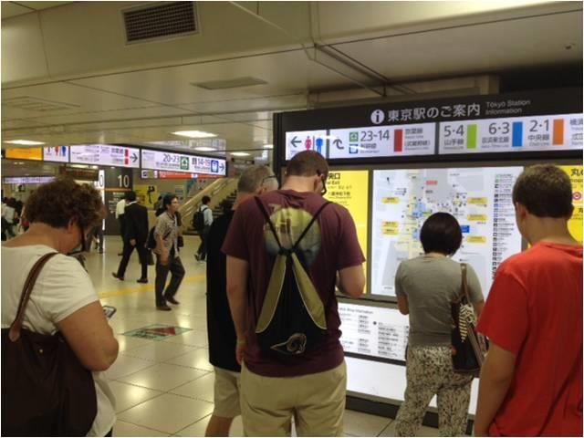
Background: Present status of indoor map

There are floor maps created by each indoor facility manager,
but there is no common digital map covering the whole area of
the underground space.

We should consider:
• to build a scheme of preparation
  of indoor map and to verify its
  availability.
• to prepare specification for 2D
  indoor maps & original 3D
  geospatial information for sharing
  information smoothly.

                                                                5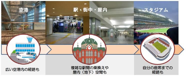
Services aimed at the project (1) Portable navigation
Foreign visitors and disabled persons should be able to travel
smoothly to their destination even in unknown places.

           Current                                      Example of service
                                          Airport               Railway terminals

                                         App

                                                                          Smooth moving
                                    Starting applications

 Searching destinations/routes
 in front of information boards

                Indoor                                      Services according to individuals
                                   Outdoor

                                                                                                6
                                                                Accessible route/facilities
                              Navigation by GNSS
Services aimed at the project (2) Disaster reduction/management

Whether people outdoor or indoor, they can receive appropriate
information at the occurrence of a disaster and can evacuate to
appropriate places according to their position.
             Current                                                Example of service

                                           ** service center:
                                           **m from here

                                                     ** school : **m
                                                     from here

                                                     Providing the location information of
                                                     evacuation facilities and route to them

Airport or terminals are very crowded
in case of large-scale disaster, without
getting appropriate information
                                                                 □□で火災発生
                                                                 ○○出口 通行可
                                                                ××出口 通行不可

                                                  Guiding evacuation and supporting            7
                                                  rescue operation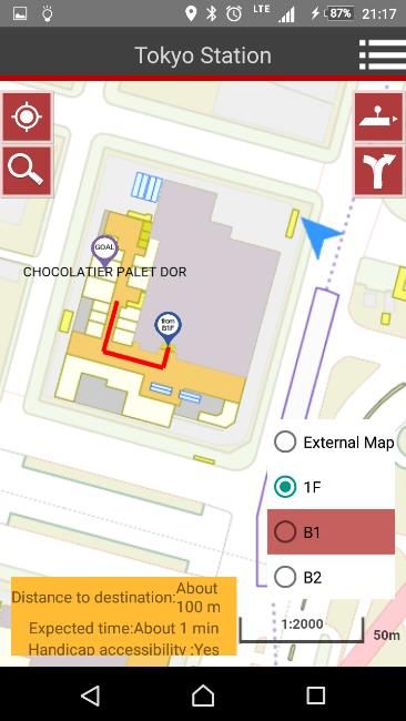
Content of the activities in FY2016

 1. Considering development and utilization of Geospatial
    Information Infrastructure such as indoor digital maps
  (1) Development of Geospatial Information Infrastructure
      - Creation of an indoor digital maps at places around Tokyo Station,
        places around Shinjuku Station, Narita Airport and Nissan Stadium
      - Construction of indoor positioning environment in these areas.
        Minimizing the number of beacons installed by using PDR and existing Wi-Fi
        to reduce the burden of installation and maintenance of beacons
  (2) Demonstration of service utilizing Geospatial Information Infrastructure
      - Developing and releasing prototype of the navigation application
      - Demonstrating guidance services for wheelchair users
      - Creating an English version
      - Corresponding to Android and iOS devices
      - Demonstration of services by private application providers
      - Ideathon / Hackathon                                                         8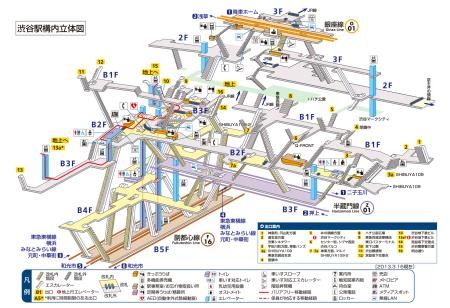
Content of the activities in FY2016

 2. Considering a scheme to continuously maintain and
    updating Geospatial Information Infrastructure
 (1) Realization of a scheme to promote maintenance, updating and
     distributing indoor digital maps
 (2) Study for indoor positioning equipment installation guidelines for
     creation of various services utilizing indoor/outdoor seamless
     positioning environment
                                           Demonstration areas
       5cm                         Narita              Tokyo               Shinjuku           Nissan
                                   Airport             Station              Station           Stadium

  Example of beacon for
  constructing positioning
       environment
                               Move in the airport   Change trains at the station, movement     Find your
                                                     in the buildings and underground malls   reserved seat
         Number of beacons                                                                                    9
                                     500                  300                  180               130
         installed each area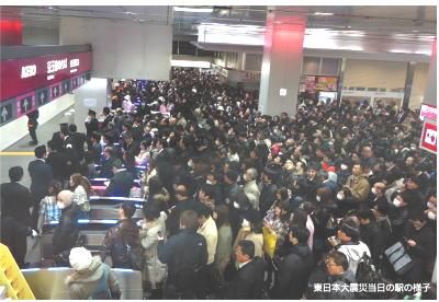
Example of indoor digital maps
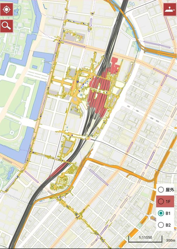
Otemachi
Yaesu
Marunouchi
Tokyo Station
Shinjuku Station
Yurakucho
Ginza
300m 100m
Places around Tokyo Station Places around Shinjuku Station
(Otemachi, Marunouchi, 10
Yurakucho, Ginza and Yaesu)Example of indoor digital maps
Terminal 3
Terminal 2
Terminal 1
300m
100m
Narita Airport Nissan Stadium
(Terminal 1, 2, 3 and station) 11Example of prototype navigation application
Release* prototype navigation application to make people feel the
convenience of the indoor digital maps and the positioning environment
*From November 30, 2016 until February 28, 2017
Start Menu Setting Setting Map
12Roadmap of main activities (draft)
FY2015 FY2016 FY2017 FY2018 FY2019 FY2020
Heading towards implementation of
high-accuracy indoor positioning system
Expand the target area: Tokyo
Target area: Cooperate with government
places around
airports, stations, stadiums
ministries and agencies and 2020
and facilities related to the
Tokyo Station carry out demonstrations.
Olympic Games
The best
Building Environment for the Private Sector Service services
in the world
Building a scheme for maintaining
and updating indoor digital maps
Making draft guidelines of •Startup of map maintenance scheme
installation of equipment for •Application development by private
indoor positioning companies
Rugby World Cup
2019 13You can also read