Hurricanes and Hail: AccuWeather's Hurricane Expert Helps you Prepare
←
→
Page content transcription
If your browser does not render page correctly, please read the page content below
Hurricanes
  and
  Hail:

AccuWeather’s

Hurricane
  Expert
  Helps

you
  Prepare


                             Dan
  Ko'lowski,


              Expert
  Senior
  Meteorologist,

                                     AccuWeather


                                      Claudia
  Dent

                VP
  Product

  Management,


                                        Everbridge


                         connect


  blog.everbridge.com


  @everbridge


  Linkedin.com
Agenda


•    Hurricane
  Risks
  and
  Mi>ga>on
  Strategies

•    2013
  Hurricane
  Forecast


•    Solving
  Communica>ons
  Challenges

•    Q&A


    LinkedIn Member? Join our LinkedIn Everbridge
    Incident Management Professionals Group

                                                               2
Housekeeping


                                  Use
  the
  Q&A

                                  func>on
  to

                                  submit
  your

                                  ques>ons.


                                       We’ll
  send
  out
  a

            @everbridge

          recording
  aNer

            #everbridge
              the
  event

            #hurricaneprep

                                                                       3
Dan
  Ko'lowski
                       Claudia
  Dent

Expert
  Senior
  Meteorologist,
     VP
  Product

  Marke9ng,

AccuWeather
                            Everbridge


                                                                              4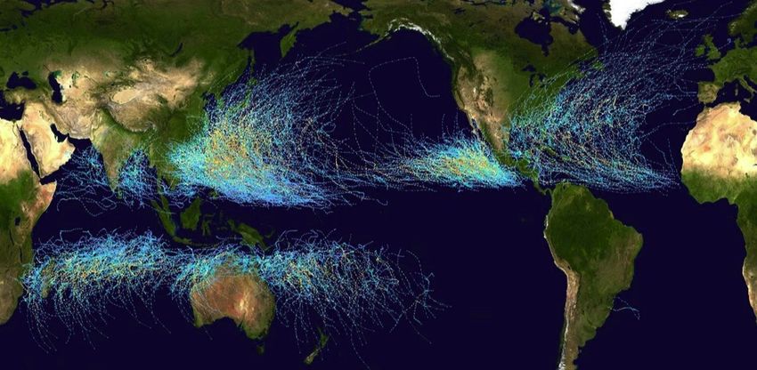
Hurricane Preparedness
For Your People,
Property, and Profits
Dan Kottlowski, Expert Senior Meteorologist
AccuWeather Enterprise Solutions

In conjunction with
What is a Hurricane?
Risks to Lives and Property
How to Mitigate Hurricane Damage
2013 Atlantic Hurricane Season Forecast
What is a Hurricane?
Hurricane Characteristics
• Largest and most destructive storm systems on Earth
• Average Diameter ~ 500 km (310 miles)
• Eye – area of calm with broken cloud cover
• Eye Wall – consists of intense thunderstorms that circle
  the eye.
• Eye Wall – region of heaviest rain and strongest wind
• Life Span – less than 1 week
• Cool water, dry air, land, and strong upper level winds
  greatly weaken the storm
8 | ©2013, AccuWeather, Inc. Confidential and Proprietary
Hurricane Definition
• Intense tropical cyclone
• Sustained winds >64 knots (73 mph)
• Cyclonic circulation in Northern Hemisphere
• Comes from Indian word that means Evil Wind/God of Evil
• Called a typhoon in western North Pacific
• Called a cyclone in India
• Called a tropical cyclone in Australia

9 | ©2013, AccuWeather, Inc. Confidential and Proprietary
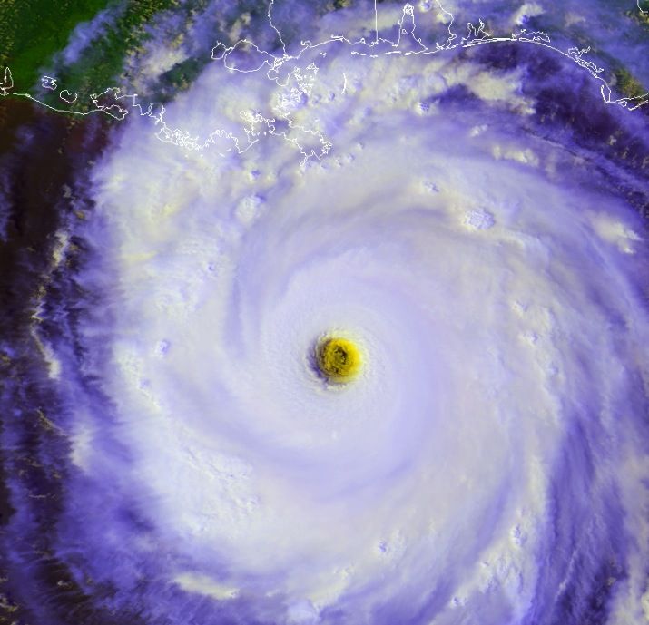
Hurricane
                                                             Dennis
                                                             • Category 3
                                                             • July 9, 2005
                                                             • 120 mph winds

10 | ©2013, AccuWeather, Inc. Confidential and Proprietary
Hurricane
Katrina
• Category 5
• Aug. 28, 2005
• 170 mph winds
11 | ©2013, AccuWeather, Inc. Confidential and ProprietaryHurricane
Rita
• Category 5
• Sept. 21, 2005
• 180 mph winds
12 | ©2013, AccuWeather, Inc. Confidential and ProprietaryA Model of a Hurricane • Dark areas are rain bands • Note that upward motion alternates with downward motion, resulting in banded rain structure • Air motion of the eye is downward and sinking 13 | ©2013, AccuWeather, Inc. Confidential and Proprietary
Tropical Cyclone Average per Year

                                                    26                12

                                                                 16             6
                             7                               9             10

• Average 86 per year worldwide
• Note the lack of storms at the equator
14 | ©2013, AccuWeather, Inc. Confidential and Proprietary
Notable Storm Tracks • Erratic & Unpredictable 15 | ©2013, AccuWeather, Inc. Confidential and Proprietary
Paths of all known Tropical Cyclones
16 | ©2013, AccuWeather, Inc. Confidential and Proprietary
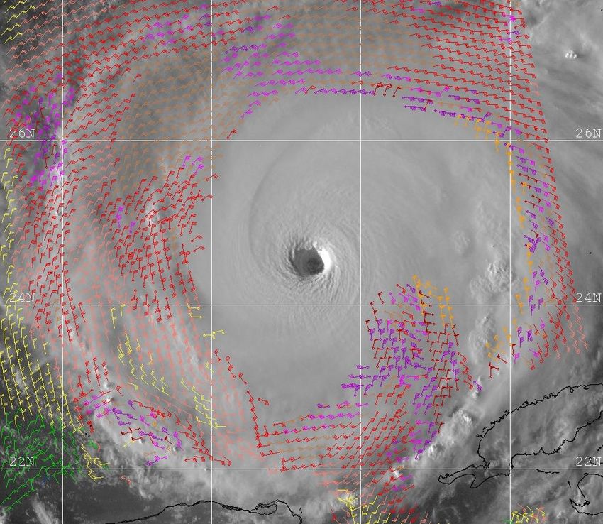
Hurricane Gloria

• Sept. 27, 1985
• Note how maximum
  winds are on the right
  side of a moving storm.
• 100 knots vs. 50 knots

17 | ©2013, AccuWeather, Inc. Confidential and Proprietary
Conditions Favorable for
Development
• Weather disturbance with circular movement
• Warm water (80 degrees F) at sufficient depth
• Winds blowing east to west 10,000 ft. to 40,000 ft.
• No significant dry air nearby
• Surface pressures below normal

18 | ©2013, AccuWeather, Inc. Confidential and Proprietary
Stages of Development
• Easterly Wave – no organization, clouds are curved
• Tropical Disturbance – clouds are organizing into a central
  mass of thunderstorms with only a slight circulation
• Tropical Depression – winds 20-34 knots (23-38 mph) and
  closed isobars
• Tropical Storm – winds 35-64 knots (39-73 mph) and
  packed isobars
• Hurricane – winds 74 mph or higher

19 | ©2013, AccuWeather, Inc. Confidential and Proprietary
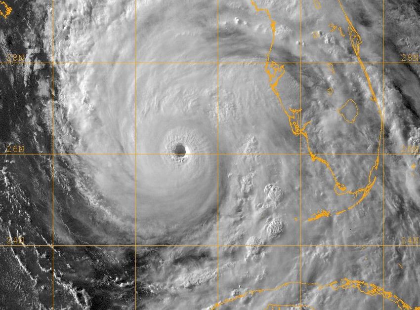
Hurricane Dean

                                                             Hurricane
                                                                         Storm
                                                                                 Depression

20 | ©2013, AccuWeather, Inc. Confidential and Proprietary
Hurricane Irene
Eye Development
21 | ©2013, AccuWeather, Inc. Confidential and ProprietaryTools Meteorologists Use to Forecast Hurricanes • Satellite Images • Derived weather variables from satellite data • Ship, buoy and costal data • Aircraft reconnaissance • Radar near coastal areas • Computer models • Historical records • Intuition 22 | ©2013, AccuWeather, Inc. Confidential and Proprietary
Hurricane Intensity
• Intensifies through the release of heat given off when
  water vapor condenses producing clouds and rain.
• Intensity is controlled by the structure of the hurricane and
  the water over which it travels.
          – If upper level structure of a hurricane allows air to flow out of the
            top with ease, then it has good upper level structure.
          – Hurricane has enough warm water for intensification if the water
            over which it travels temperature is 80 degrees or higher.
          – If both the upper level structure and the warm water work in
            concert, then a hurricane will intensify, sometimes more rapidly
            than expected.

23 | ©2013, AccuWeather, Inc. Confidential and Proprietary
Hurricane Intensity
• Winds at least 74 mph
• Rated on scale from 1-5, where 5 is most intense with
winds over 155mph
• Ratings at or above 3 are considered major hurricanes
which cause significant damage
• Only 3 hurricanes have hit the U.S. at category 5 intensity
– 1935 : Labor Day
– 1969 : Camille
– 1992 : Andrew
24 | ©2013, AccuWeather, Inc. Confidential and ProprietarySaffir-Simpson Hurricane Scale
Tropical
Category 1 Category 2 Category 3 Category 4 Category 5
Storm
39 - 73 mph 74 - 95mph 96 -110 mph 111-130 mph 131-155 mph > 155 mph
(34-63 kt) (64-82 kt) (83-95 kt) (96-113 kt) (114-135 kt) (> 136 kt)
Alberto Katrina Frances Katrina Charley Andrew
(2006) (FL - 2005) (2004) (LA - 2005) (2004) (1992)
Allison Claudette Isabel Wilma Hugo Camille
(2001) (2003) (2003) (FL- 2005) (1989) (1969)Risks to Lives and Property
The Hurricane Problem
• Potential loss of life
• Major to catastrophic damage
• Storm surge
• Inland flooding
• Damaging winds
• Disruption of business and commerce
• Number of tropical cyclones per year

27 | ©2013, AccuWeather, Inc. Confidential and Proprietary
Potential Loss of Life
Deadliest Hurricanes
                                                                   Location        Year   Deaths
                                                             Galveston, TX         1900   8000

                                                             Lake Okeechobee, FL   1928   1836

                                                             Katrina               2005   1200+

                                                             FL Keys & Texas       1919    600

                                                             New England           1938    600

                                                             Florida Keys          1935    408

                                                             Audrey (LA & TX)      1957    390

                                                             NE U.S.               1944    390

28 | ©2013, AccuWeather, Inc. Confidential and Proprietary
Major to Catastrophic Damage
Costliest Hurricanes at Landfall
Hurricane Year Category Cost (billions)
Katrina 2005 3 108.0
Sandy 2012 1 50.0
Ike 2008 2 29.5
Andrew 1992 5 26.5
Wilma 2005 3 21.0
Ivan 2004 2 18.8
Irene 2011 1 16.6
Charley 2004 4 15.1
Rita 2005 3 12.0
Frances 2004 3 9.5
Allison 2001 TS 9.0
Jeanne 2004 3 7.7
29 | ©2013, AccuWeather, Inc. Confidential and Proprietary Hugo 1989 4 7.0Storm Surge
• Build up of high water & waves
ahead of the hurricane landfall.
• Lower pressure causes sea
water to rise (1 inch for every 1
millibar drop in pressure)
• Dependent upon
– Slope of continental shelf
– Shape of immediate coast
– Hurricane strength, size, and
movement
30 | ©2013, AccuWeather, Inc. Confidential and ProprietaryStorm Surge Danger • Winds can generate huge waves, which can be dozens of feet high. • Heights ranging from 1 to 25 feet • Waves become swells that move outward in all directions. 31 | ©2013, AccuWeather, Inc. Confidential and Proprietary
Who is most at risk?
                                                       Value of homes at risk    Number of homes exposed
                  Area
                                                       of storm surge damage    to flood or surge inundation
Long Island, NY                                               $99 billion                 196,740
Miami / Palm Beach, FL                                        $44.9 billion               119,778
Virginia Beach, VA                                            $44.6 billion               253,214
New Orleans, LA                                               $39 billion                 120,181
Tampa, FL                                                     $27 billion                 177,453
Houston, TX                                                   $20 billion                 140,896
Jacksonville, FL                                              $19.6 billion               112,165
Charleston, SC                                                $17.7 billion               34,126
Corpus Christi, TX                                            $4.7 billion                35,153
Mobile, AL                                                    $3 billion                  22,178
                  Total                                       $319.5 billion             1,221,884
 32 | ©2013, AccuWeather, Inc. Confidential and Proprietary
33 | ©2013, AccuWeather, Inc. Confidential and Proprietary
Inland Flooding
• Notable Hurricane Floods
Hurricane Location Year
Irene Eastern U.S. 2011
Lee PA, NY, NJ 2011
Katrina New Orleans 2005
Frances & Ivan Eastern U.S 2004
Isabel VA & MD 2003
Allison Houston 2001
Floyd Carolinas 1999
Agnes PA 1972
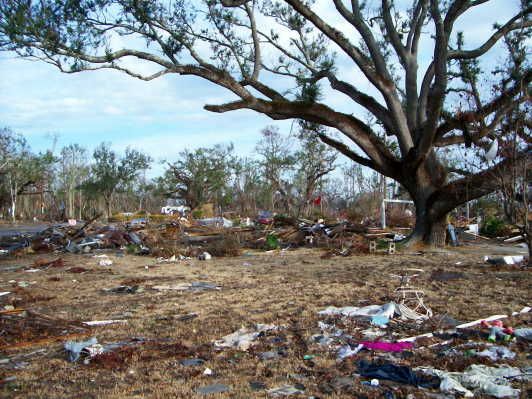
34 | ©2013, AccuWeather, Inc. Confidential and ProprietaryDamaging Winds • Wind damage at landfall is much worse than wind damage well inland in most storms • Tornadoes spinning off of tropical cyclones can cause extensive damage • Any loose object can become wind debris in moments 35 | ©2013, AccuWeather, Inc. Confidential and Proprietary
Before Katrina…
…After Katrina
Disruption of Business & Commerce

           New Orleans, LA after                               Houston, TX after
             Hurricane Katrina                               Tropical Storm Allison
38 | ©2013, AccuWeather, Inc. Confidential and Proprietary
Number of Tropical Cyclones per Year
Period Tropical Cyclones Hurricanes
1886 – 2000 8.7 5.1
1951 – 2000 10.0 5.9
1961 – 2000 10.0 5.8
1971 – 2000 10.1 5.6
1981 – 2000 10.3 5.8
1986 – 2000 10.7 6.1
1991 – 2000 11.0 6.4
ü 2000 – 2012 15.6 7.5
39 | ©2013, AccuWeather, Inc. Confidential and Proprietary2012 Hurricane Season
Name Dates Max Wind (mph)
Alberto May 19 – 22 60
Beryl May 26 – 30 70
Chris June 19 – 22 75
Debby June 23 – 27 60
Ernesto August 1 – 10 85
Florence August 3 – 6 60
Helene August 9 – 18 45
Gordon August 15 – 20 110
Isaac Aug. 21 – Sept. 1 80
Joyce August 22 – 24 40
Kirk Aug. 28 – Sept. 2 105
Leslie Aug. 30 – Sept. 11 75
Michael September 3 – 11 115
Nadine Sept. 11 – Oct. 4 90
Oscar October 3 – 5 50
Patty October 11 – 13 45
Rafael October 12 – 17 90
Sandy October 22 – 29 110
Tony October 22 – 25 50
40 | ©2013, AccuWeather, Inc. Confidential and ProprietaryHow to Mitigate Hurricane Damage
How can we mitigate the damage?
• Change building codes
• Prevent building in flood
  prone areas
• Build stronger and
  smarter homes
• Better drainage
• Build better levees
• Modernize utilities

42 | ©2013, AccuWeather, Inc. Confidential and Proprietary
Tropical Cyclone Preparedness
• When warnings and advisories are issued be sure
  that you, your home, and your business are prepared
  for what lies ahead.
• Secure your…
          – Home
          – Business
          – Self

43 | ©2013, AccuWeather, Inc. Confidential and Proprietary
Secure Home
• Be prepared now
– Stock up on food & water
– Insurance coverage (wind, flood, etc.)
– Have a plan now of how you will react
• Get prepared as storm approaches
– Board up windows
– Remove potential wind debris
– Locate supplies
– Center of home, away from windows
44 | ©2013, AccuWeather, Inc. Confidential and ProprietarySecure Business • Board up windows • Elevate items from floors • Back up power supply • Back up files & computers • Off-site locations • Plan how to get back up and running after storm goes through 45 | ©2013, AccuWeather, Inc. Confidential and Proprietary
Secure Self
• When / will you evacuate
          – Right in the path
          – Glancing blow

• Do you live in a flood prone area
• Balance securing your home and
  your business
• Know those around you need to
  prepare as well
• Family & Pets

46 | ©2013, AccuWeather, Inc. Confidential and Proprietary
How accurate are the forecasts?
• Very good for large, well behaved, hurricanes
• Slow moving hurricanes make track forecasts less accurate.
• Forecasters have trouble determining how strong a hurricane
is beyond 24 hours.
• Ability to communicate potential hazards for a specific place
has improved dramatically over the past 20 years.
– A forecast made for the third day out is just as accurate as a 24 hour
forecast was 15 years ago.
– Less lives are lost due to the complex, but well organized methods of
warning and evacuating people.
47 | ©2013, AccuWeather, Inc. Confidential and Proprietary2013 Atlantic Hurricane Season Forecast
Factors Influencing 2013 Season
• Warm water temperatures across most of the Atlantic Basin.
• ENSO neutral pattern expected through the season, so no
  important climatic enhancement from El Nino or La Nina.
• Warm ocean water in the main developmental region (off the
  African coast and Caribbean) supports lower surface
  pressure in these sub regions.
• Lower pressure promotes tropical cyclone development and
  intensification.

49 | ©2013, AccuWeather, Inc. Confidential and Proprietary
Sea Surface
                                               Temperature
                                                 Anomaly
                                             for June 8, 2013

                        Main Developmental Region

     SEA SURFACE TEMPERATURES IN THE MAIN DEVELOPMENTAL
     REGION ARE RUNNING WARMER THAN LAST YEAR AT THIS TIME
50
AMO
Atlantic
Multi-Decadal
Oscillation
• Ocean water temperatures
have been rising since
1995 due to the AMO AMO
• Note the increase in
storms since 1995. Years
Tropical
Cyclones
Hurricanes
Major
Hurricanes
1968-1995 9.6 5.2 1.6
1995-2012 15.2 8.0 3.7
51 | ©2013, AccuWeather, Inc. Confidential and ProprietaryMDR • Sea surface temperature forecast from the Japanese Meteorological Agency model for June, July, and August 52 | ©2013, AccuWeather, Inc. Confidential and Proprietary
July, August, September                              August, September, October

• The ECMWF climate model shows near to slightly above
  normal SST in the main developmental region

53 | ©2013, AccuWeather, Inc. Confidential and Proprietary
June - August                                                                  September - November
                                             Courtesy of the JMA climate model run May 2013

 • Japanese Climate Model shows above normal rainfall (blue)
   over the Caribbean and eastern Gulf of Mexico in June,
   July, and August then mostly in the Caribbean
 • This might suggest the more active areas of the basin
 54 | ©2013, AccuWeather, Inc. Confidential and Proprietary
• UKMET rainfall anomaly forecast July, August and September shows above normal rainfall over much of the Caribbean and the Texas to Louisiana coast and East coast 55 | ©2013, AccuWeather, Inc. Confidential and Proprietary
• Quasi-Biennial Oscillation (QBO) is a phenomenon that
  brings high level westerly winds for 24-48 months then
  easterly winds for the next 24-48 months.
• Enhancing factor in Tropical Storm formation when in the
  positive phase creating high level wind flow from the west.
56 | ©2013, AccuWeather, Inc. Confidential and Proprietary
• Lower shear promotes Tropical Cyclone development
• Strong shear limits development
57 | ©2013, AccuWeather, Inc. Confidential and Proprietary
Analog Years
Year Storms Hurricanes Major Hurricanes Landfalls
1952 7 7 6 2
1996 13 9 6 4
ü 2001 15 9 4 3
2012 19 10 1 4
Average 14 9 4 3
• Note: considering that technology allows us to detect and
track more storms the total number of storms in 1952
could increase by 3-5.
58 | ©2013, AccuWeather, Inc. Confidential and ProprietaryHurricane Season Prediction for
Atlantic Basin
NOAA
AccuWeather 2012 Season
Forecast
Forecast 2013 Numbers Normal
2013
Tropical
16 13-20 19 12
Storms
Hurricanes 8 7-11 10 6
Major
4 3-6 1 3
Hurricanes
U.S. No forecast
3 issued 4 2
Landfalls
59 | ©2013, AccuWeather, Inc. Confidential and ProprietaryCaveats
• Expecting 4 major hurricanes
• In some years there are signals in climate models and
analog years that give us an idea of what coastal areas
are more vulnerable.
• Size and the speed at which the storm moves is just as
important as the Saffir-Simpson wind scale classification.
• Too early to tell where stronger hurricanes might track.
– Sandy was classified as a category 1 hurricane before landfall.
– Size and speed at which a storm moves can be just as important
as the Saffir-Simpson Wind Scale Classification.
60 | ©2013, AccuWeather, Inc. Confidential and ProprietarySolving
Communica>on
Challenges
Claudia
Dent
VP,
Product
Management,
Everbridge
Severe
Weather:
By
the
Numbers
Everbridge
During
Hurricane
Sandy:
+ Over
10,000,000
No>fica>ons
+ 23%
sent
during
the
storm
+ 156%
increase
over
Hurricane
Irene
+ 31%
increase
in
ci>zen
opt-‐in
62The
Need
for
Effec>ve
Communica>ons
Employee
/
CiCzen
ProtecCon
&
Life
Safety
Field
&
Mobile
Team
CoordinaCon
+ Safety
Alerts
+ Work
schedule
changes
+ Severe
weather
alerts
+ ShiN
cancella>ons
+ Facili>es
and
Home
Evacua>ons
+ Incident
escala>ons
+ ShiN
Filling/Cancella>ons
+ On-‐demand
conference
calls
Incident
Response
&
Management
ConCnuity
of
OperaCons
+ Unplanned
event
needs
+ Employee
alerts
+ Travel
and
weather
advisories
+ Branch/office
closure
updates
+ Response
Team
Ac>va>on
+ On-‐the-‐fly
conference
calls
+ Regional
Collabora>on
+ Remote
roll-‐calling
&
safety
verifica>on
63Communica>on
Challenges
Delivery
Challenges
Responder
Challenges
Errors
under
duress
Have
the
messages
been
received?
Old
contact
lists
Have
the
right
teams
been
no>fied?
Too
many
systems
Are
the
messages
clear
and
complete?
Inconsistent
processes
Can
we
really
reach
everyone?
Limited
access
to
front-‐line
intelligence
What
if
we
get
audited?
Can
we
prove
it?
64Smart
Delivery:
Combining
Speed
and
Intelligence
Smart
Delivery
Delivery
Automa>on
Visual
Intelligence
Social
Intelligence
Mobile
Management
Incident
Management
65Assured
Response:
Connec>ng
&
Confirming
Smart
Delivery
Assured
Response
Delivery
Automa>on
Target
the
Individual
Visual
Intelligence
Contact
Confirma>on
Social
Intelligence
Two-‐way
Mobile
Communica>ons
Mobile
Management
Situa>onal
Responses
Incident
Management
Live
Status
Repor>ng
66Smart
Delivery:
Automa>on
and
Speed
+ Single
page
no>fica>on
process
+ ‘One-‐click’
sending
speeds
launch
+ Pre-‐determined
message
templates
&
Select
contacts
based
on
groups,
contact
lists
reduce
errors
rules
&
GIS
map
+ Mul>-‐language
support
with
text
to
loca>ons
speech
improves
message
clarity
+ Call-‐throfling
flexibility
paces
delivery
to
infrastructure
capacity
Only
one
page
no>fica>on
process
&
“one-‐click”
sending
67Smart
Delivery:
Visual
Intelligence
+ Map-‐based
contact
targe>ng
increases
accuracy
using:
– Zip
code
– Street
address
– Radius
from
a
point
Only
integrated
GIS
– Custom
shapes
mapping
with
unified
contact
data
+ 100+
weather
alerts
and
map-‐based
tracking
for:
– Severe
Thunder
Storms
– Lightning
&
Hail
– Tornados
&
Flash
Foods
– Snow
&
Ice
Condi>ons
68Smart
Delivery:
Social
Intelligence
+ Monitor
internal
data
&
frontline
responses
automa>cally
to
capture
missing
informa>on
and
improve
situa>onal
intelligence
Only
integrated
social
+ Accurately
Mobile
Member
media
monitoring
&
Social
tM
rack
edia
weather
around
key
loca>ons
and
automa>cally
no>fy
contact
aler>ng.
Only
mobile
recipient
app
with
rich
two-‐
way
communica>ons.
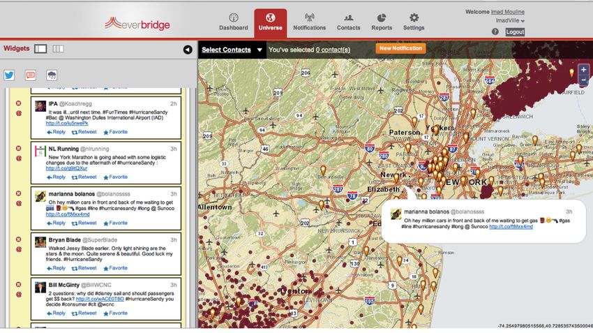
69Weather…
70Everbridge
Weather
Alerts
and
No>fica>ons
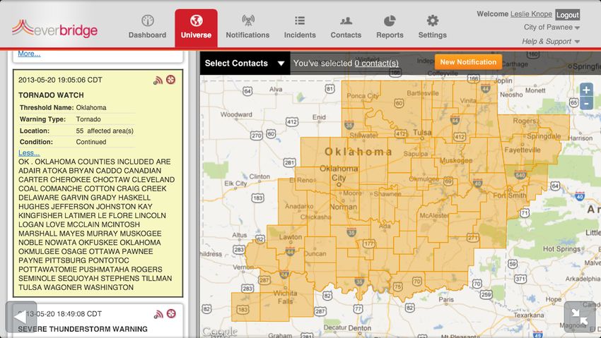
Specific
polygons
Tornado
Watch
&
Warning
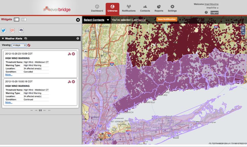
71Everbridge
Weather
Alerts
and
No>fica>ons
Automa>cally
no>fy
contacts
based
on
weather
event
OR
Select
contacts
interac>vely
in
the
map
Receive
important
weather
alerts
Automa>cally
trigger
no>fica>ons
Fully
customizable
Smart
  Delivery:
  Social
  Intelligence


Social
  Media
Smart
  Delivery:
  Social
  Intelligence


Social
  Media


                                                    74
Smart
Delivery:
Mobile
Manager
+ Manage
and
monitor
communica>ons
while
‘on
the
go’
using
no>fica>on
templates,
real-‐>me
repor>ng
and
map-‐based
targe>ng
Only
mobile
management
app
with
integrated
GIS-‐
targe>ng.
No>fy
&
run
reports
Build
new
messages
Select
contacts
on
maps
75Assured
Response:
Targe>ng
the
Individual
76Assured
Response:
Required
Confirma>on
+ Target
contacts
using
personal
preferences
to
improve
message
confirma>on
Alan
Sue
Dave
Phil
Janice
First
A'empt
ü
cell
CONFIRMED
1/2/13
10:02:03
AM
work
text
message
ü
email
CONFIRMED
1/2/13
10:02:56
AM
BlackBerry
Second
A'empt
work
cell
ü
CONFIRMED
BlackBerry
1/2/13
10:03:35
AM
cell
work
Third
A'empt
text
message
email
email
V
NO
RESPONSE
instant
message
PDA
V
NO
Rpager
pager
ESPONSE
Re-‐send?
Re-‐send?
77Assured
Response:
Two-‐Way
Mobile
Communica>ons
+ Communicate
with
and
geo-‐locate
frontline
resources
even
under
adverse
network
condi>ons
like
low
bandwidth
or
connec>vity
Only
dedicated
mobile
recipient
applica>on
with
two-‐way
communica>on.
7
Receive
push
noCficaCons
Respond
using
polling
Share
details
&
photos
8Trusted
Planorm:
When
Needed
Most
Trusted
Planorm
Smart
Delivery
Assured
Response
Unified
Data
Management
100%
Redundant
Systems
Scalable
Elas>c
Infrastructure
Open
Integra>ons
79Trusted
Planorm:
The
Everbridge
Suite
Send
and
manage
Manage
incidents
with
Maximize
situa>onal
Provide
two
way
no>fica>ons
across
automated
rules
intelligence
with
social
communica>on
geographies
and
based
communica>on
media,
mobile
and
between
Mobile
enterprises
and
tracking
weather
Members
&
Managers
Global
Elas>c
Infrastructure
•
Unified
Data
Management
•
Open
APIs
Repor>ng
and
Analy>cs
•
Compliance
and
Audit
•
Everbridge
University
80Trusted
Planorm:
1500+
Customers
Corporate
Finance
Healthcare
EducaCon
State/Local
Government
TransportaCon
Global
81Q&A
Note:
Presenta>on
slides
will
be
available
on
our
blog
at
blog.everbridge.com
Use
the
Q&A
func>on
to
submit
your
ques>ons.
82Contact
Informa>on
&
Free
Demo
Thank
you
for
joining
us
today!
See
Everbridge
Interac>ve
Visibility
In
Ac>on
Visit
our
blog
to
see
upcoming
webinars.
Everbridge
Resources
On-‐Demand
Webinars:
www.everbridge.com/webinars
White
papers,
case
studies
and
more
www.everbridge.com/resources
Follow
us:
www.everbridge.com/blog
@everbridge
Linkedin
You can also read