Impact of global warming on climatic patterns of Chhattisgarh Plain- an analytical modeling
←
→
Page content transcription
If your browser does not render page correctly, please read the page content below
Trans.Inst.Indian Geographers
                                                                                              ISSN 0970-9851

Impact of global warming on climatic patterns of Chhattisgarh
Plain- an analytical modeling

Agnisha Chakraborty*, West Bengal; B. Hema Malini and Anuja Tigga,
Visakhapatnam

                                             Abstract
   In the context of global warming, the study predicts the possible changes in existing climates
   in Chhatisgarh plain with 2°C and 6°C temperature increase based on meteorological data
   on mean monthly temperature and rainfall for seven IMD stations collected for a period
   of 30 years (1986-2015) and average monthly water balance of all the individual stations
   using Thornthwaite and Mather water balance technique (1955). Analysis of thermal regime
   conditions revealed that the entire region at present experiences Megathermal climate
   (A′a′) with varying intensities but with increasing temperatures to the tune of 2°C and 6°C,
   Megathermal climates will intensify all over Chhattisgarh plain. On the other hand, analysis
   of moisture index (Im) indicated that the study area which is at present experiencing dry sub
   humid type of climate (C1) may experience semi-arid (D) climate with an increase of 6°C
   and there may not be any part of Chhattisgarh plain which will experience dry sub humid
   type of climate in future. The region is likely to become drier with rise in temperature..

   Keywords: Water balance, mega thermal, moisture index, climate, dry sub humid, semiarid.

Introduction
Systematic categorization of climate of any         are based on empirical approach (Terjung
region is more important in the present times       and Louie, 1972). Among the numerous
of great climate concern as the influence of        classifications that have been formulated
climate on living things has both immediate         by empirical approach, three schemes have
effects as well as complicated responses            gained wider acceptance, which include
associated with climatic change. Thus, the          Koppen’s (1900 and 1936), Thornthwaite
purpose of climatic classification is to provide    (1948 and 1955) and Miller (1959) schemes.
a comprehensive description of the climate          Among those, Thornthwaite’s scheme of
in terms of active factors of which heat and        classification has been found to be more
moisture are the most decisive in determining       rational with practical value. He coined the
climatic types.                                     concept ‘Potential Evapotranspiration’ (PE)
    Based on the significance of classification     which is the maximum amount of water
of climates, around 169 schemes have                which would be lost to the atmosphere
evolved, which are mainly based on genetic          from a surface comparatively covered with
and empirical approaches. Of which, 21              vegetation, if there is sufficient water in the
are based on genetic approach and 148               soil at all times for full use (Thornthwaite,

                                                                  Transactions | Vol. 43, No. 1, 2021 | 93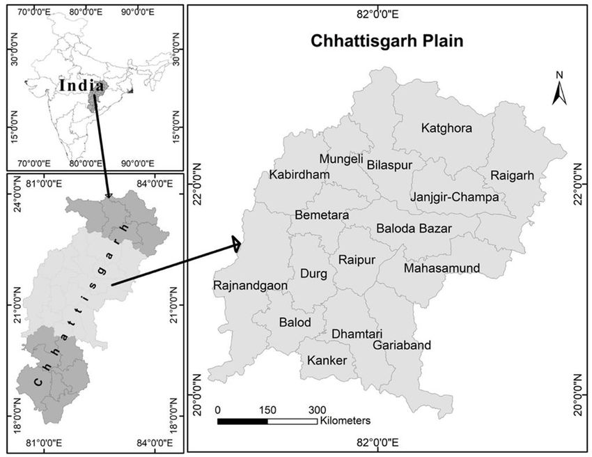
1948), a unique characteristic feature of     climate (Hema Malini, 1988). Further, water
PE which can be applicable to derive both     balance analysis is not only useful for the
thermal as well as moisture regime climatic   identification of climatic types but also useful
types (Subrahmanyam and Sastri, 1969a).       for the identification of drought spells, their
Thornthwaite developed a book-keeping         duration, intensity and spread and also to
procedure namely water balance which          assess the suitability of crops in a particular
is helpful in the evaluation of various       region. These types of analyses are useful for
hydrological elements like water storage,     the farmers and planners of agriculture (Hema
water surplus and water deficit, which        Malini and Pampa Choudhury, 2010). Thus,
in turn provide quantitative solutions to     Thornthwaite scheme has gained popularity
many hydrological questions in a given        even among the ecologists, agricultural
region (Hema Malini, 1993). A systematic      scientists and many others who carry out
analysis of water balance of any region       regional studies as its benefits are immense.
clearly explains the water need of a region       The main objective of the paper is to
and provides a more realistic and clear       assess the existing climate types of the
idea about the wetness and dryness of a       Chhattisgarh plain by applying thermal and

Fig 1: Chhattisgarh Plain: Location

94 | Transactions | Vol. 43, No. 1, 2021
moisture regime concepts of Thornthwaite           moisture affectivity (Subrahmanyam and
and Mather (1955) and to predict the impact        Hema Malini, 1978). For the luxuriant
of global warming on the present climatic          growth and development of vegetation,
patterns of Chhattisgarh plain.                    the two important climatic requirements
                                                   are thermal efficiency and moisture
Study area                                         affectivity. The tropical regions have high
Chhattisgarh Plain lies between19°47′ 14′′ N       thermal efficiencies on account of high air
and 23° 6′ 58′′N latitudes and 80° 23′ 55′′ E      temperatures and almost constant length
and 83° 47′ 50′′ E longitudes which covers an      of the day throughout the year. Moisture
area of 72184 Sq. Km. This extensive Plain         affectivity is not such simple parameter
is located in the central part of the State of     because it depends upon the precipitation
Chhattisgarh (Fig. 1). The average annual          regime, which in turn is governed by general
rainfall is more than 1500 mm in the eastern       circulation of the atmosphere. Analysis of
region, and 1300 mm in the western region.         thermal regime provides the information
The region is mainly drained by the river          regarding the available thermal potentiality,
Mahanadi and its tributaries. Because of the       which is essential for the growth of vegetation.
presence of flat and fertile soils with adequate   It is only where both the thermal efficiency
water supply, this region is prosperous in         and moisture affectivity are optimal that the
agriculture. The paper aims at analyzing           development of vegetation is very prosperous
the existing climatic types in Chhattisgarh        and therefore the ecosystems are well
plain and to assess whether there will be          balanced climatically (Subrahmanyam and
any change in the climatic patterns due to         Hema Malini, 1977).
temperature rise.
                                                   Thermal regime
Data and methodology                               Thornthwaite considered PE, a parametric
Water balance technique of Thornthwaite            index of thermal efficiency and is expression
and Mather (1955) has been applied for the         of day length as well as temperature of a
present climatic analysis. To compute the          region to classify the climates. PE which is
water balance, monthly minimum, maximum            also termed as Thermal Efficiency (TE) is not
temperature and monthly rainfall data for          only a growth Index but expresses growth in
about 30 years have been obtained from the         terms of the amount of water that is needed
records of India Meteorology Department            for the growth (Thornthwaite, 1948). Based
(IMD) for the seven IMD stations existing          on the annual values of PE/TE, five major
in the study area. Data on existing patterns       thermal provinces namely Megathermal,
of land use/land cover and forests have also       Mesothermal, Micro thermal, Tundra and
been obtained from the statistical handbook        Frost were identified by Thornthwaite. A
and economic review of Chhattisgarh (2013-         Mega thermal climate is the climate which
14) published by Directorate of Economics          experience highest temperatures throughout
and Statistics, Government of Chhattisgarh.        the years with PE/TE above 1140 mm.
                                                   Mesothermal climate experiences persistent
Climatic classification                            cold or heat conditions and experience PE
Thornthwaite’s scheme of classification of         between 570 mm and 1140 mm. Micro
climates (1948) is based on the fundamental        thermal climate is the one where mean annual
consideration of thermal efficiency and            temperatures are low and PE varies between

                                                                 Transactions | Vol. 43, No. 1, 2021 | 95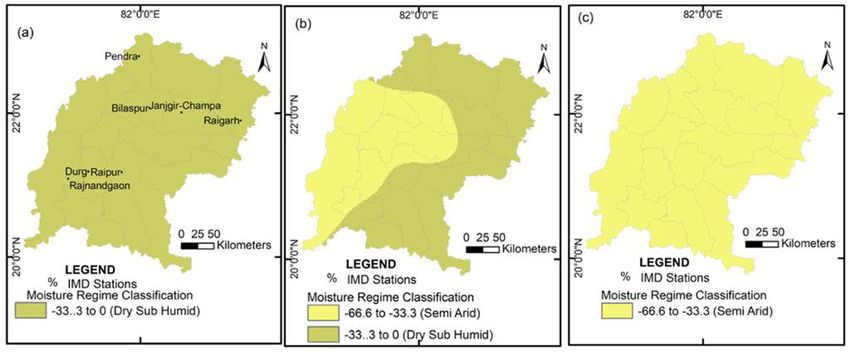
Table 1: Classification scheme of thermal regime
       Thermal Efficiency(mm)                Symbol                           Climatic Type
             Above 1140                         A'                            Megathermal
               1140-997                         B'₄
               997-855                          B'₃
                                                                              Mesothermal
               855-712                          B'₂
               712-570                          B'1
               570-427                          C'₂
                                                                              Microthermal
               427-285                          C'1
               285-142                          D'                               Tundra
              Below 142                         E'                                Frost
     Source: Thornthwaite and Mather, 1955

285 and 570 mm. Frost and Tundra are the cold              Thornthwaite made sub classification
climates with low thermal efficiency. To find         to find out the seasonal variation of TE by
out climate types based on thermal regime,            computing Summer Concentration of Thermal
the parameters namely annual Thermal                  Efficiency (SCTE). SCTE is the percentage
Efficiency and Summer Concentration                   of the sum of the thermal efficiencies for the
of Thermal Efficiency (SCTE) has been                 three highest summer months to the annual
computed for the main and sub classifications         total (Table 2).
respectively. Thornthwaite’s general scheme
                                                          Based on the scheme of main
of thermal regime classification is presented
                                                      classification (Table1) and sub classification
in Table 1 and Table 2 used as a basis to
                                                      (Table2) of Thornthwaite’s thermal regime,
demarcate major and sub thermal regime
                                                      it was revealed that all the seven stations of
categories. Scheme of Thornthwaite climatic
                                                      study area are experiencing major type of
classification to derive major climates based
                                                      Mega thermal type of climate (A’) as their
on Thermal regime classes is given in the
                                                      annual thermal efficiency values are above
Table.1.

Table 2: Thermal Regime Sub-classification
              SCTE (%)                       Symbol                           Climate Type
              Below 48.0                        a'                            Megathermal
               48.0-51.9                        b'₄
               51.9-56.3                        b'₃
                                                                              Mesothermal
               56.3-61.6                        b'₂
               61.6-68.0                        b'1
               68.0-76.3                        c'₂
                                                                              Microthermal
               76.3-88.0                        c'1
             Above 88.0                         d                                Tundra
     Source: Thornthwaite and Mather, 1955

96 | Transactions | Vol. 43, No. 1, 2021
Table 3: Sub classification of Megathermal (A’) and SCTE megathermal (a’) Climates
Thermal Efficiency (mm) Intensity Symbol SCTE (%) Symbol
1885 and above Very extreme A'6 34.0-31.9 a'6
1713-1884 Extreme A'5 36.3-34.0 a'5
1570-1712 Very high A'4 38.8-36.3 a'₄
1427-1569 High A'₃ 41.6-38.8 a'₃
1283-1426 Moderate A'₂ 44.6-41.6 a'₂
1140-1282 Low A'1 48.0-44.6 a'₁
Source: compiled by the authors
Table 4: Climatic classification of Chhattisgarh plain - thermal regime
Thermal Regime Classification- Present Situation
Stations Annual TE
Megathermal Type Symbol SCTE (%) Symbol
(mm)
Pendra 1394 Moderate A'₂ 39.26 a'₃
Raipur 1615 Very high A'₄ 35.80 a'5
Bilaspur 1433 High A'₃ 41.8 a'₂
Durg 1553 High A'₃ 36.40 a'₄
Raigarh 1575 Very high A'₄ 36.64 a'₄
JanjgirChampa 1579 Very high A'₄ 36.54 a'₄
Rajnandgaon 1605 Very high A'₄ 35.18 a'5
Source: computed by the authors
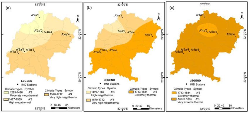
Fig 2 (a-c): Climate types of Chhattisgarh Plain – Thermal Regime. (a) Present condition
(b) Rise of 2°C temperature (c) Rise of 6°C temperature
Transactions | Vol. 43, No. 1, 2021 | 971140 mm and Megathermal sub type (a’) type. the GIS environment. Considering the spatial
To find out the variations in the intensity of extent of the study area it was found that about
major (A’) and sub type (a’) of Megathermal 14,717 Km2 experiences A’₂ Megathermal
types of climates the values above 1140 mm climate, about 19,328. Km2 comes under A’₃
of TE and below 48 % of SCTE were further Megathermal type of climate and more than
divided into sub categories respectively. half of the region (35,767Km2) experiences
Table 3 provides sub divisions of A’ and a’ A’₄ Megathermal type of climate.
categories of thermal regime. The spatial patterns of SCTE percentage
Table-4 shows that Pendra and its indicates that the northwestern and northern
adjacent parts in the north-west of the study parts of the study area, experience SCTE
region experience Megathermal A’₂ type above 37.5%, thus comes under the influence
of climate with the thermal efficiencies of a’₃ Megathermal sub type. Considerable
below 1425 mm. The north-eastern and the part of central Chhattisgarh plain (surrounding
central parts (area around Bilaspur and Durg) Bilaspur) experience SCTE above 41 percent,
experience A’₃ type of Megathermal climate thus, a’₂ megathermal sub-type of climate is
with thermal efficiency values ranging from observed here. The remaining area of the
1425 mm to 1567 mm. The south-western, plain including southern, south-western,
southern and south-eastern parts surrounding south-eastern and some part of the central
plain experience a’₄ and a’₅ type of climate.
Rajnandgaon, Raipur, Janjgir Champa and
Raigarh experience Megathermal A’₄ type of On the basis of the above analysis it is
climate with the thermal efficiencies above found that the Chhattisgarh plain comes
1567 mm (Fig.2 a). under Megathermal climate with varying
magnitudes of SCTE. The distribution
To understand the spatial distribution of thermal efficiency over Chhattisgarh
pattern of climates, isopleths of annual thermal Plain revealed that the entire region has
efficiencies values and the percentage of Megathermal types of annual and summer
summer concentration of thermal efficiencies thermal efficiencies, more than adequate to
have been interpolated to generate maps in support Megathermal type of vegetation.
Table 5: Moisture regime
Climatic Type Symbol Moisture Index (Im %)
Perhumid A 100 and above
Extremely humid B4 80 to 100
Very humid B3 60 to 80
Moderately humid B2 40 to 60
Low humid B1 20 to 40
Moist subhumid C2 0 to 20
Dry subhumid C1 -33.3 to 0
Semiarid D -66.7 to -33.3
Arid E -100 to -66.7
Source: Thornthwaite and Mather (1955)
98 | Transactions | Vol. 43, No. 1, 2021Moisture regime moisture conditions. Exceptional conditions
Thermal potentiality is responsible for the mean a surplus in a dry climate and a deficit in a
growth of greenery in any region. But it is moist climate (Hema Malini, 1993). This type
only moisture regime that determines the of analysis is very useful to identify the degree
luxuriance of vegetation development. Thus of intensity (large, moderate or little) of water
in eco-climatological investigations, both deficiency and water surplus in the moist and
thermal as well as the moisture factors are to dry climatic regions respectively (Tigga and
be considered to understand the real thermal Rao, 2011). Thornthwaite’s scheme has the
and moisture potentialities of a region limitation to explain for dry climate. Hence,
(Subrahmanyam and Hema Malini, 1979). Carter and Mather (1966) have extended the
classification and have given appropriate
To analyze climates, based on moisture
regime of any region it is essential to derive classes to varying degree of dryness. Table
the water balance elements namely Potential 6 represents the sub classification based on
Evapotranspiration (PE) water surplus (WS) seasonal variation in moisture effectiveness.
and water deficit (WD). These elements help In order to derive sub classification of
computing aridity index (Ia) and humidity moisture regime of Chhattisgarh plain based
index (Ih). Index of aridity is the ratio of water on seasonal variation, Index of aridity and
deficit to PE (Ia = (WD/PE) x 100) and Ih is Index of humidity are considered.
the ratio of water surplus to PE (Ih = (WS/PE) The analysis of moisture indices of
x100). As water surplus and water deficiency Chhattisgarh plain revealed that the plain
alternate seasonally they play an important experiences moisture index between -8.12
role in the determination of Index of Moisture and -32.7 percent. Thus, all the stations come
(Im) which determines the classification of under the category of dry sub humid climate
climates. Moisture index is computed with (C₁;Im= -33.3 to 0). Bilaspur, Rajnandgaon
the help of the following formula: and Durg in the western part of the study area
Im = Ih – Ia; Where, Im = Moisture Index, are experiencing lower range of moisture
Ih = Humidity Index, Ia = Aridity Index indices indicating the dryness in the climate.
Pendra in the extreme northern part of the
Thornthwaite (1955), in his scheme of plain is experiencing comparatively high
climatic classification used index of moisture moisture effectiveness (-8.0%).
(Im), as the basis to demarcate arbitrary
boundaries between major types of climate. The sub classification based on seasonal
Table 5 gives the moisture regimes (Im) variation of effective moisture indicates little
according to Carter and Mather (1966) in so or no water surplus (d) condition which means
far as the dry regions (Im< 0) are concerned that water deficiency prevails throughout
the year except in one or two months. Thus,
and categorizations of humid regions (Im>
as a whole the study area comes under the
0) is originally proposed by Thornthwaite
influence of ‘C1d’ type of climate. The spatial
(1948) is given in Table 5.
distribution of moisture indices indicates
To demarcate the variations within the that though the Chhattisgarh plain is broadly
broad categories, Thornthwaite had adopted coming under the influence of dry sub humid
the seasonality of adequate and exceptional climate (C1), there is a variation in moisture
Transactions | Vol. 43, No. 1, 2021 | 99Fig 3 (a-c): Climate types of Chhattisgarh plain – Moisture Regime. (a) Present condition
(b) Rise of 2°C temperature (c) Rise of 6°C temperature
Table 6: Moisture regime sub classification
Moist Climate (A, B, C₂) Aridity Index
r Little or no water deficiency 0-10
s Moderate summer water deficiency 10 to 20
w Moderate winter water deficiency 10 to 20
s Large summer water deficiency 20+
w Large winter water deficiency 20+
Dry Climates (C₁, D, E ) Humidity Index
d Little or no water surplus 0 to 16.7
s Moderate winter water surplus 16.7 to 33.3
w Moderate summer water surplus 16.7 to 33.3
s Large winter water surplus 33.3+
w large summer water surplus 33.3+
Source: Thornthwaite and Mather (1955)
effectiveness throughout the region. At Global warming and its impact
present, the northern parts of the plain is The climate models show the variations in
experiencing comparatively higher moisture both temperature and precipitation patterns
effectiveness than the central and western with significant regional variability due to
parts (Fig.3.a), while the sub classification anthropogenic activities (Giorgi, 2006).
indicates that the region is experiencing‘d’ Analysis of the past 140 years of temperature
type of climate with little or no water surplus. data of the world revealed that global
Thus, the plain is experiencing dry sub humid temperature is rising at a rapid rate. In several
climate with little or no water surplus (C1d) studies made by Basu (1990), Mithra (1991),
and the entire plain can support dry deciduous Liu and Chen (2000), Oliver and Hiddore
type of natural vegetation. (2002) Kothawale and Kumar (2005), IPCC
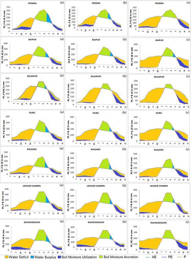
100 | Transactions | Vol. 43, No. 1, 2021Fig 4: Water Balance elements (mm) of Chhattisgarh Plain (a) Present condition
(b) Rise of 2°C temperature (c) Rise of 6°C temperature
Transactions | Vol. 43, No. 1, 2021 | 101(2007) Bhutiyani et al., (2007) and You et al of water balance predictive models for 2°C
(2008) warming trend has been reported in and 6°C rise of temperatures. Based on the
their respective study regions. These studies annual Thermal Efficiency (TE) of each
suggested an overall increase of temperature representative station, thermal regime types
between 0.4 °C and 0.8 °C over past century. of climates of Chhattisgarh plain were
Further, studies of Riebeek (2010) and US categorized.
Environment Protection Agency (2012)
The analysis revealed that with the rising
predicted a rise of temperature between
1.5°C and 5.8°C by 2100. These changes temperatures by 2°C and 6°C there will be
in temperature patterns certainly impact the a significant change in the existing thermal
water balance of any given region which regime climates of Chhattisgarh Plain. At
in turn alters the existing climatic patterns. present, Chhattisgarh Plain is experiencing
Hema Malini (1997, 2014) found shifting Megathermal (A’) climate with varying
of climatic pattern towards drier side of intensities such as low (A’1) moderate (A’₂),
the climatic spectrum in India as well as in high (A’₃) and very high (A’₄), extreme (A’5)
Hokkaido (Japan), if the temperatures rise and very extreme (A’6). Table 8represents
by 4°C. Keeping the change in the water thermal regime climates for the present and
balances of the study region with the rising with rise of temperatures.
temperatures, an attempt is made to assess the Table 8 reveals that with the temperature
possible changes in the climatic patterns of increase by 2°C and 6°C, thermal conditions
Chhattisgarh region. are intensified in the entire Chhattisgarh plain
Influence of Warming from the existing thermal regime conditions
(Fig. 2 a, b). The entire region will come
To assess any change in the existing climatic
under the influence of very high intensities of
pattern due to global warming, monthly
average water balances were recomputed Mega thermal climate without exception. The
for the predicted rise of temperatures after intensification is more with 6°C of increase
adding 2°C and 6°C for each month. Fig.4 (Fig. 2c).This means the thermal potential
(a, b, c) provides graphical representations of the region will be increased enormously
Table 8: Shifts in thermal regime climates of Chhattisgarh plain due to global warming
With Existing Temperature
With 2 °C Temperature Increase With 6 °C Temperature Increase
Conditions
Stations
TE in Megathermal TE in Megathermal TE in Megathermal
Symbol Symbol Symbol
mm type mm type mm type
Pendra 1394 Moderate A'₂ 1589 Very high A'₄ 1923 Very extreme A'6
Raipur 1615 Very high A'₄ 1790 Extreme A'₅ 2120 Very extreme A'6
Bilaspur 1433 High A'₃ 1576 Very high A'₄ 1846 Very high A'₅
Durg 1553 High A'₃ 1726 Extreme A'₅ 2059 Very extreme A'6
Raigarh 1575 Very high A'₄ 1733 Extreme A'₅ 2026 Very extreme A'6
Janjgir Champa 1579 Very high A'₄ 1741 Extreme A'₅ 1889 Very extreme A'6
Rajnandgaon 1605 Very high A'₄ 1773 Extreme A'₅ 2114 Very extreme A'6
Source: Computed by authors
102 | Transactions | Vol. 43, No. 1, 2021Table 9: Shifts of moisture regime in Chhattisgarh plain due to global warming
With Temperature Rise
Present Situation
Stations By 2.0 °C By 6.0 °C
Im% Climate type Symbol Im% Climate Type Symbol Im% Climate Type Symbol
Pendra -8.12 Dry Sub humid C₁ -19.4 Dry Sub humid C₁ -33.4 Semi-arid D
Raipur -24.9 Dry Sub humid C₁ -32.2 Dry Sub humid C₁ -42.8 Semi-arid D
Bilaspur -32.7 Dry Sub humid C₁ -38.9 Semi-arid D -47.8 Semi-arid D
Durg -29.1 Dry Sub humid C₁ -36.3 Semi-arid D -46.5 Semi-arid D
Raigarh -21.5 Dry Sub humid C₁ -28.7 Dry Sub humid C₁ -38.9 Semi-arid D
Janjgir Champa -24.3 Dry Sub humid C₁ -31.3 Dry Sub humid C₁ -36.7 Semi-arid D
Rajnandgaon -28.2 Dry Sub humid C₁ -34.9 Semi-arid D -45.5 Semi-arid D
Source: Computed by authors
with rising temperature. Table 9 shows the As a result, dryness will increase leading to
changes in the moisture regime climates in the shifting of dry sub humid climate towards
Chhattisgarh with temperature increase. semi-arid climate. Remedial measures can be
With 2°C of temperature increase, the adopted to combat the repercussions of the
areas around Bilaspur, Durg and Rajnandgaon global warming.
will experience semi-arid climate while References
remaining four stations will experience same
Bhutiyani, M. R., Kale, V. S., & Pawar, N. J.
dry sub humid climate (Fig.3b). With 6°C
(2007). Long-term trends in maximum,
increase of temperature all the station will
minimum and mean annual air temperatures
experience semi-arid type of climate (Fig.3c)
across the Northwestern Himalaya during the
and dry sub humid type of climate will be
twentieth century. Climatic Change, 85(1),
completely eliminated to support only thorn 159-177.
type of vegetation.
Carter, D. B., & Mather, J. R. (1966). Climatic
Conclusion classification for environmental biology.
Climate types based on Thornthwaite’s CW Thornthwaite Associates, Laboratory
thermal regime and moisture regime revealed of Climatology. Publ. in climatology, lab of
that at present the Chhatisgarh plain comes climate, Centerton, Vol. 19 (4).305-395.
under Megathermal climate as it has rich Giorgi, F. (2006). Climate change hot-spots.
thermal potential. However, because of Geophysical research letters, 33(8).
rainfall limitation, the region is experiencing
Griffiths, J. F. (1978). Applied climatology : An
dry sub humid type of moisture regime
Introduction (2nd ed.). Oxford University
climate. Further, assumption of temperature
Press.
increase by 2°C and 6°C indicates that
the thermal potential of the region may Intergovernmental Panel on Climate Change
be increased enormously and present day (IPCC) (2007). Climate Change 2007:
Megathermal climates may be intensified. Climate change impacts, adaptation and
Transactions | Vol. 43, No. 1, 2021 | 103vulnerability - Summary for policymakers. Malini B. H. (1997). Global warming and climate
Contribution of Working Group II to the change predictive models for temperate and
Fourth Assessment Report of the IPCC. tropical regions, The Deccan Geographer,
IPCC (1996). Climate Change 1995: Impacts, Vol.35 (1), Pp. 35-47.
adaptations and mitigation of climate change: Malini B. H., Sumiko K., Rao N. K., Reddy, V.
scientific-technical analyses, Contribution of B., & Naidu, T. G., (2014). Impact of global
working group II to the second assessment warming on cropping patterns – case studies
report of the Intergovernmental Panel on of India and Hokkaido island (Japan), Journal
Climate Change. (R. T. Watson, M. C. of Urban and Regional studies, Vol.1 (1), Pp.
Zinyowera, & R. H. Moss, Eds.) Cambridge
81- 91.
University Press.
Malini B. H., & Chaudhuri, P. (2010). Drought
Koppen, W., (1900). Versuch einer Klassification
Vulnerability and its implications on
der Kilimate, Vorzugsweise nach ihren
Agriculture in Orissa State. Punjab
Beziehungen zur Pflenzenwelt, Geograph. 2,
Geographer, 6, 1-15.
Vol. 6, pp. 593-611.
Koppen, W. (1936). Das Geographische system Miller, A. A. (1959). Climatology. New York:
der Kilimate. In: Handbuch der Klimatologic. Mehtewn London and E. P. Dulton and Co.
Getruder Borntraeger, Berlin, Vol.1, Part C. INC
Kothawale, D.R., and Rupa Kumar K. (2005). On Mithra, A.P. (1991). Global warming-green
the recent changes in surface temperature house effect on the environment ,The Hindu,
trends over India, Geophysical Research Kasturi and sons Ltd., Madras, Pp. 76-79.
Letters, 32, L18714. Oliver, J. E., & Hidore, J. J. (2002). Climatology -
Liu, X., & Chen, B. (2000). Climatic warming in An Atmospheric Science. Singapore: Pearson
the Tibetan Plateau during recent decades. Education Ptc. Ltd.
International Journal of Climatology: A
Riebeek Holli (2010). Global Warming: Feature
Journal of the Royal Meteorological Society,
articles. http://earthobservatory.nasa.gov/
20(14), 1729-1742.
Features/GlobalWarming/
Malini B. H. (1984). Water balance techniques and
their applicability. Research Bulletin No.22, Subrahmanyam, V. P., & Hema Malini, B.
Indian Geographical Studies, Geographical (1977). Studies in ecoclimatology of Andhra
Research Center. pp. 48-58. Pradesh- Thermal regime, The Deccan
Malini B. H. (1988) Ecoclimatological aspects Geographer, Vol. 15 (2), Pp.297- 306.
of drought prone area of Andhra Pradesh - Subrahmanyam, V. P., & Hema Malini, B. (1978).
Anantapur. Report submitted to University Drought prone areas of Andhra Pradesh. The
Grants Commission, New Delhi. Pp. 21-79. Deccan Geographer, Vol. 17 (2), Pp. 442-449.
Malini B. H. (1993). Daily water balance and
Subrahmanyam, V. P., & Sastry, C.V. S. (1969).
irrigation scheduling in Visakhapatnam
district-Andhra Pradesh. Report Submitted Climatic analogues for the dry regions of
to the University Grants Commission, New India. Tropical Ecology, Vol.10 (1),Pp.
Delhi. 34-44.
104 | Transactions | Vol. 43, No. 1, 2021Terjung, W. H., & Louie, S. S. (1972). Energy Agnisha Chakraborty*
input-output climates of the world: A Lecturer,
preliminary attempt. Archiv für Meteorologie, Prabhu Jagatbandhu College,
Geophysik und Bioklimatologie, Serie B, Andul, Howrah, West Bengal
20(2), 129-166.
B. Hema Malini
Thornthwaite, C. W. (1948). An approach Senior Fellow, ICSSR,
toward a rational classification of climate, Department of Geography,
Geographical Review, Vol. 38, (1), Pp. 55-94.
Andhra University,
Thornthwaite, C.W. & Mather, J.R. (1955). The Vishakhapatnam
water balance, Publication of climatology,
Laboratory of Climatology, Vol.5 (1), Pp. Anuja Tigga
1-104. Professor,
Thornthwaite, C. W. & Mather, J.R. (1957). Department of Geography,
Instruction and tables for computing potential Andhra University,
evapotranspiration and the water balance, Vishakhapatnam
Publi. In Climatology, Lab. of Climate, Vol.
10(3), Pp. 185-311. *Author for correspondence
E-mail: chakrabortyagnisha@gmail.com
Tigga, A., & Rao, G.V. N. (2011). Assessment
of climates in Jharkhand State- A moisture
regime approach, Eastern Geographer, Vol.
XVII (1), Pp. 79-84.
You, Q., Kang, S., Aguilar, E., & Yan, Y. (2008).
Changes in daily climate extremes in the
eastern and central Tibetan Plateau during
1961 to 2005. Journal of Geophysical
Research, 113.
Transactions | Vol. 43, No. 1, 2021 | 105You can also read