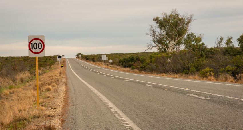
Indian Ocean Drive (Yanchep to Lancelin) Planning Study
←
→
Page content transcription
If your browser does not render page correctly, please read the page content below
FACT SHEET
APRIL 2021

Indian Ocean Drive (Yanchep to Lancelin)
Planning Study

Main Roads is undertaking a planning study for the Indian Ocean Drive between Breakwater
Drive, Yanchep and Seaview Drive, Lancelin.
The planning study aims to identify what    number of connection points, while            Some of the key points raised so far
the long-term requirements are for Indian   allowing for appropriate levels of lot and    include consideration of:
Ocean Drive, expected requirement           network access.
                                                                                          • 	Potential future residential, industrial,
for a dual carriageway and intersection
                                            It is important to understand that this          agricultural and tourism developments;
treatments. This comprehensive
                                            is a planning study only. No funding is       • 	Environmental constraints;
investigation will inform and guide the
                                            currently available for construction works.   • 	Emergency access and egress (bushfire,
future of Indian Ocean Drive within
the regional transport network and                                                           traffic incidents etc);
                                            WHAT HAVE WE DONE SO FAR?                     • 	Dark Sky and Astro-tourism
surrounding community.
                                            In December 2019, we started discussions         surrounding the Gingin Gravity
Once the ultimate road requirement and      with several key stakeholders, including         Discovery Centre and Observatory
location is agreed, we will identify and    the Department of Planning, Lands and         • 	Road safety initiatives;
protect a nominal road reserve boundary.    Heritage, Shire of Gingin, Wheatbelt
                                                                                          • 	Access requirements, and future
This will help provide certainty for        Development Commission and the
                                                                                             intersection designs along Indian
landholders.                                Department of Biodiversity, Conservation
                                                                                             Ocean Drive); and
While these road upgrades will have         and Attractions.
                                                                                          • 	Ag-lime routes and heavy vehicle
some impact on adjoining and nearby         The focus was on providing an overview           access requirements.
land and communities, we will minimise      of the study, and seeking input from each
this as much as possible by working                                                       Based on projected land-use changes and
                                            stakeholder on planning considerations
collaboratively with landowners.                                                          traffic growth, we have identified that a
                                            and expectations. In late 2020, in addition
                                                                                          dual carriageway is likely to be required
Direct lot accesses and local road          to the above, we met with the Office of
                                                                                          in the future. We have developed a
connections introduce potential conflict    Road Safety, the Department of Fire and
                                                                                          preliminary access strategy, which
points for traffic on the road network.     Emergency Services, the Gravity Discovery
                                                                                          identifies future intersection treatments
To optimise safety and efficiency on        Centre and Observatory, and Local
                                                                                          and upgrades at key locations that will
the network, we need to minimise the        Government Authorities.
                                                                                          improve safety and efficiency along the
                                                                                          route.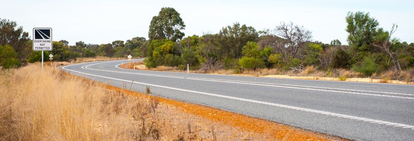
PRELIMINARY ACCESS STRATEGY
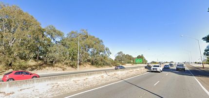
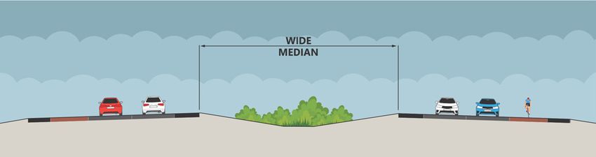
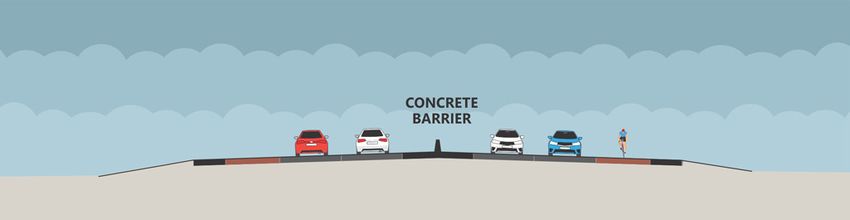
A future Indian Ocean Drive dual carriageway would have a 14 In locations where there are constraints on both sides, such as
metre wide, vegetated median. development or environmental issues, a narrow median with
concrete barrier would minimise impacts.
This type of carriageway is similar to Bussell Highway in Capel.
This type of reduced median width with central barrier is similar
to Tonkin Highway.
INTERSECTIONS
There are 18 intersections along the route which will require Based on analysis and consultation to date, Main Roads has
upgrading or modification to improve safety as traffic identified the following intersection types for consideration
volumes grow.
Intersection Proposed Access Treatment
and Intersection
Military Rd Reduced access, no connection (Military
Rd connecting south of Indian Ocean Dr,
to Wanneroo Rd)
Wilbinga Rd Relocate t-intersection north improving
sightlines and safety
Barragoon Rd Install roundabout
King Dr Reduced access, to left-in/left-out
Croot Pl Reduced access, to left-in/left-out
Gingin Brook Rd Upgrade to roundabout (realign eastern
end of Caraban Rd south, to tie-in with
Caraban Rd Gingin Brook Rd)
Glenrowan Rd Retain t-intersection
Sovereign Hill Dr Install seagull
Guilderton Rd Install seagull
Tuart Rise Install seagull
Seabird Dr Install seagull
Greenwood Coast Rd Retain current t-intersection
Bennies Rd Retain current t-intersection
Ledge point Rd Install seagull
K.W. Rd Install seagull
Lancelin Rd Install roundabout
Seaview Dr Reduced access to Left-in / Left-out
Direct property accesses Consolidate where feasible To be
investigated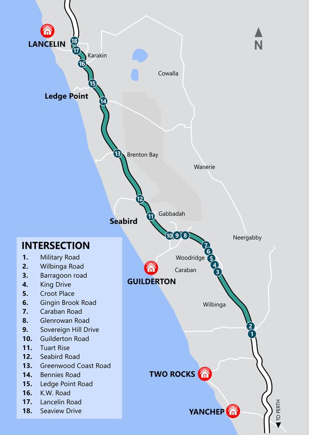
Roundabouts                                                           Seagull intersection
Roundabouts are proposed at side roads where surrounding              (turning and acceleration lanes)
land use is expected to build up in the future, including Gingin      Seagull intersections provide deceleration and acceleration lanes
Brook Road, Lancelin and Guilderton. Traffic volumes turning to       for left and right turning vehicles. These are used on medium
and from these roads are already significant, and are expected        volume side roads, particularly where there are high proportions
to continue to grow. Roundabouts improve safety by slowing            of heavy vehicles (e.g lime trucks), as it allows slower moving
vehicles through the intersection, and eliminating the risk of        vehicles to reach the operating speed before merging with traffic
right-angle crashes.                                                  on Indian Ocean Drive.

Left-in / Left-out                                                    T-intersection
Three locations have been identified for potential conversion         Side roads that have low traffic volumes will remain as
to left-in / left-out turning movements only, based on existing       T-intersections. However safety will be improved by adding
concerns and safety risks for right turning vehicles. Right turning   turn pockets for vehicles turning into the side road, as well as
vehicles will still have access via nearby intersections on Indian    including a wide central median to allow vehicles turning right
Ocean Drive, and parallel local roads that retain access but at       from the side road to stop in the median and wait for a gap in
lower speeds. This reduces possible conflict on Indian Ocean          traffic.
Drive, while improving efficiency and safety for all road users.

COMMUNITY ENGAGEMENT PROCESS
   As a priority, we started meeting with potentially impacted landowners adjacent to Indian Ocean Drive in late April 2021 to seek
   their feedback, including those whose properties may be impacted by a dual carriageway.
   From the wider community, we would like to understand what you think the future Indian Ocean Drive might look like. You can
   have your say in one of the following ways:

    Online consultation                                   Community Drop In sessions                   Email, phone or post
    Once you have reviewed the fact sheet,                Main Roads will be holding some local        You can email us via indianoceandrive@
    Main Roads will be undertaking some                   community Drop in Sessions. Details of       mainroads.wa.gov.au
    online consultation on the MySay                      these sessions will be available on our
                                                                                                       Call us on 138 138 and ask to speak
    platform mysaytransport.wa.gov.au A                   webpage mainroads.wa.gov.au/indian-
                                                                                                       with our Community Engagement
    link will be available on our webpage                 ocean-dr.
                                                                                                       Representative for the Indian Ocean
    mainroads.wa.gov.au/indian-ocean-dr
                                                          You can also register your interest via      Drive Planning Study.
                                                          indianoceandrive@mainroads.wa.gov.au
                                                                                                       Please phone or email us if you wish
                                                                                                       to register your preference to receive
                                                                                                       updates via Australia post.

HOW YOUR FEEDBACK IS USED                                                         HOW WILL I RECEIVE FEEDBACK?
All feedback will be reviewed to determine any changes that                       Our email subscriber database is the quickest way you can be
may be required, and how these might inform further changes                       updated as the study progresses.
to the preferred design. We will then provide the outcomes of
                                                                                  To ensure you receive information, please subscribe for project
this engagement process to landowners and the Indian Ocean
                                                                                  updates at mainroads.wa.gov.au/indian-ocean-dr
Drive communities.
                                                                                  Alternatively, you can contact us via email at
                                                                                  indianoceandrive@mainroads.wa.gov.au

This document can be provided in alternative formats upon request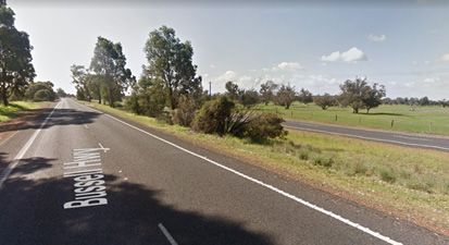


You can also read