Initial Study/Environmental Checklist Form for the All Right Self-Storage Project Santee, California - CUP2019-05/AEIS2019-10
←
→
Page content transcription
If your browser does not render page correctly, please read the page content below
Initial Study/Environmental
Checklist Form for the
All Right Self-Storage Project
Santee, California

CUP2019-05/AEIS2019-10
Prepared for
City of Santee
10601 Magnolia Avenue
Santee, CA 92071

Prepared by
RECON Environmental, Inc.
3111 Camino del Rio North, Suite 600
San Diego, CA 92108
P 619.308.9333

RECON Number 9603
January 2021
Initial Study Checklist/Environmental Checklist Form

TABLE OF CONTENTS

1.    Project Title ...................................................................................................... 1
2.    Lead Agency Name and Address .................................................................. 1
3.    Contact Person and Phone Number ............................................................ 1
4.    Project Location .............................................................................................. 1
5.    Project Applicant/Sponsor’s Name and Address ...................................... 1
6.    General Plan Designation ............................................................................. 1
7.    Zoning ................................................................................................................ 1
8.    Project Description ......................................................................................... 2
9.    Project Site Existing Conditions and Surrounding Land Use(s).......... 3
10.   Other Required Agency Approvals or Permits Required....................... 4
11.   Have California Native American tribes traditionally and culturally
      affiliated with the project area requested consultation pursuant to
      Public Resources Code Section 21080.3.1? ................................................. 4
12.   Statement of Environmental Findings ....................................................... 4
13.   Summary of Environmental Factors Potentially Affected..................... 5
14.   Determination .................................................................................................. 5
15.   Environmental Checklist Form .................................................................. 14
      15.1      Aesthetics ........................................................................................................... 16
      15.2      Agriculture Resources........................................................................................ 18
      15.3      Air Quality.......................................................................................................... 20
      15.4      Biological Resources........................................................................................... 28
      15.5      Cultural Resources............................................................................................. 31
      15.6      Energy ................................................................................................................ 34
      15.7      Geology and Soils ............................................................................................... 40
      15.8      Greenhouse Gas Emissions ............................................................................... 43
      15.9      Hazards and Hazardous Materials ................................................................... 45
      15.10     Hydrology and Water Quality ........................................................................... 49
      15.11     Land Use and Planning ..................................................................................... 52
      15.12     Mineral Resources.............................................................................................. 54
      15.13     Noise ................................................................................................................... 54
      15.14     Population and Housing .................................................................................... 65
      15.15     Public Services ................................................................................................... 66
      15.16     Recreation........................................................................................................... 67
      15.17     Transportation/Traffic ....................................................................................... 68

                                             All Right Self-Storage Project
                                                            i
Initial Study Checklist/Environmental Checklist Form

TABLE OF CONTENTS (cont.)

        15.18     Tribal Cultural Resources ................................................................................. 70
        15.19     Utilities and Service Systems ........................................................................... 72
        15.20     Wildfire ............................................................................................................... 75
        15.21     Mandatory Findings of Significance ................................................................. 76
16.0 Mitigation, Monitoring, and Reporting Program................................... 79
17.0 Checklist References .................................................................................... 83

FIGURES

1:      Regional Location ............................................................................................................ 7
2:      Project Location on USGS Map....................................................................................... 8
3:      Project Location on Aerial Photograph ........................................................................... 9
4a:     Phase I Site Plan ........................................................................................................... 10
4b:     Phase II Site Plan .......................................................................................................... 11
5a:     Phase I Landscape Concept Plan .................................................................................. 12
5b:     Phase II Landscape Concept Plan ................................................................................ 13
6:      Construction Noise Contours ........................................................................................ 57
7:      Daytime On-Site Noise Contours .................................................................................. 62
8:      Nighttime On-Site Noise Contours ............................................................................... 63

TABLE

1:      Air Quality Impact Analysis Trigger Levels ................................................................ 22
2:      Summary of Maximum Build-out Construction Emissions ........................................ 23
3:      Project Trip Generation ................................................................................................. 24
4:      Summary of Maximum Build-out Operational Emissions .......................................... 25
5:      Off-site Construction Vehicle Fuel Consumption ........................................................ 35
6:      On-site Construction Equipment Fuel Consumption .................................................. 35
7:      Vehicle Fuel/Electricity Consumption .......................................................................... 37
8:      Operational Electricity and Natural Gas Use .............................................................. 39
9:      Construction Noise Levels at Off-site Receivers .......................................................... 58
10:     Vehicle Traffic Noise Levels without and with Project ............................................... 59
11:     On-site Generated Noise Levels at Adjacent Property Lines ...................................... 61
12:     Cumulative Project List ................................................................................................ 78
13:     Mitigation, Monitoring, and Reporting Program ......................................................... 80

                                               All Right Self-Storage Project
                                                              ii
Initial Study Checklist/Environmental Checklist Form

TABLE OF CONTENTS (cont.)

APPENDICES

A:     Air Quality and Greenhouse Gas Model Results (California Emissions Estimator
        Model Output Files), prepared by RECON Environmental, Inc., August 20, 2020
B:     Biological Survey for the All Right Self-Storage Project, prepared by RECON
        Environmental, Inc., July 8, 2020
C:     Archaeological Survey for the All Right Self-Storage Project, prepared RECON
        Environmental, Inc., July 8, 2020
D:     Energy Use Calculations, prepared by RECON Environmental, Inc., August 20, 2020
E-1:   Report of Preliminary Geotechnical Investigation Cottonwood Industrial Site,
        prepared by Geotechnical Exploration, Inc., July 10, 2014
E-2:   Updated Geotechnical Investigation and Infiltration Testing, prepared by
        Geotechnical Exploration, Inc., March 28, 2018
E-3:   Update and Grading Plan Review, prepared by Geotechnical Exploration, Inc.,
        March 3, 2020
F:     Sustainable Santee Plan Project Consistency Checklist, prepared by RECON
        Environmental, Inc., July 10, 2020
G:     Phase I Environmental Site Assessment, prepared by Partner Engineering and
        Science, Inc., April 12, 2019
H-1:   Letter of Determination of No Hazard to Air Navigation, prepared by the Federal
        Aviation Administration, May 26, 2020
H-2:   San Diego County Regional Airport Authority Airport Land Use Commission
        Consistency Determination, August 19, 2020
I:     Hydrology/Hydraulics Study, prepared by Excel Engineering, March 3, 2020
J:     Storm Water Quality Management Plan, prepared by Excel Engineering,
        March 4, 2020
K:     Noise Analysis for the All Right Self-Storage Project, prepared by RECON
        Environmental, Inc., August 31, 2020
L:     Public Service Availability Forms, prepared by the Padre Dam Municipal Water
        District, December 3, 2019

                              All Right Self-Storage Project
                                            iii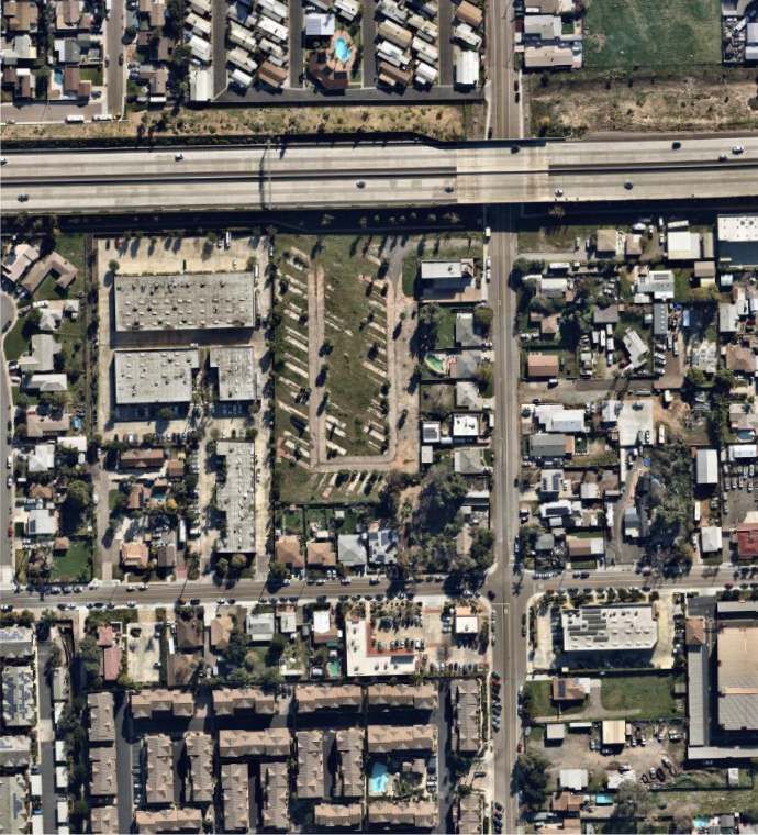
Initial Study Checklist/Environmental Checklist Form

                              CITY OF SANTEE
              INITIAL STUDY/ENVIRONMENTAL CHECKLIST FORM
                           CUP2019-05/AEIS2019-10

1. Project Title

All Right Self-Storage Project

2. Lead Agency Name and Address

City of Santee
10601 Magnolia Avenue
Santee, CA 92071

3. Contact Person and Phone Number

Christina Rios
Associate Planner
City of Santee
(619) 258-4100 x157
crios@CityofSanteeCa.gov

4. Project Location

8708 Cottonwood Avenue, Santee, CA 92071
Assessor’s Parcel Number 384-370-25-00

5. Project Applicant/Sponsor’s Name and Address

Mr. Olivier Andreu
All Right Storage, LP
11300 Sorrento Valley Road #250
San Diego, CA 92121

6. General Plan Designation

Existing: Light Industrial (IL) with Residential-Business (R-B) Overlay
Proposed: Light Industrial (IL) with Residential-Business (R-B) Overlay

7. Zoning

Existing: Light Industrial (IL)
Proposed: Light Industrial (IL)

All reports and documents referenced in this Initial Study are on file with the City of Santee,
Department of Development Services, 10601 Magnolia Avenue, Santee, CA 92071. Telephone
Number: (619) 258-4100, ext. 167. A digital copy is available from the City website:
http://cityofsanteeca.gov/services/project-environmental-review.

                                  All Right Self-Storage Project
                                             Page 1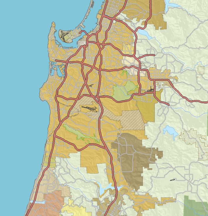
Initial Study Checklist/Environmental Checklist Form
8. Project Description
The All Right Self-Storage Project (project) site is located at 8708 Cottonwood Avenue on an
approximately 3.0-acre parcel (Assessor’s Parcel Number 384-370-25-00), located in the city
of Santee, California, north of State Route 52 (SR-52) and west of Cottonwood Avenue. The
project site is currently accessed via Cottonwood Avenue just north of the underpass beneath
SR-52. Land uses surrounding the project site include single-family residences to the north,
single-family residences and a commercial structure to the east, SR-52 to the south, and a
business park consisting of commercial/industrial uses to the west. Figure 1 shows the
project’s regional location. Figure 2 shows the project’s specific location on U.S. Geological
Survey map. Figure 3 shows an aerial photograph of the project site and vicinity.
The project proposes to construct a 148,458-square-foot (sf) self-storage facility which would
be developed in two phases. Phase I would construct a three-story, 78,080 sf, mechanically
air-conditioned self-storage structure within an incidental office (Building A); a one-story,
4,413 sf self-storage structure (Building B); and a one-story, 5,120 sf self-storage structure
with an 800 sf private garage, along with a 1,130 sf caretaker’s living unit as the second story
(Building C). Phase I would also provide 26 parking spaces on-site, along with 57 recreational
vehicle (RV) parking spaces for rent or for rental trucks for moving purposes. The project
would only allow for parking of these vehicles and would not include a service area.
Phase II would remove the recreational vehicle parking spaces for rent and construct a one
story, 8,309 sf self-storage structure (Building D) and a three-story, mechanically air
conditioned, 50,606 sf self-storage structure (Building E). Phase II would also add an
additional three parking spaces, resulting in a total of 29 parking spaces on-site. The proposed
site plans for Phases I and II are presented in Figures 4a and 4b, respectively. The proposed
landscape concept plans for Phases I and II are presented in Figures 5a and 5b, respectively.
A Mini Storage/Public Storage is subject to a conditional use permit (CUP) in the Light
Industrial (IL) zone and a Recreational Vehicle Storage Yard is subject to a minor conditional
use permit (MCUP) in the IL zone. Therefore, the project will require a CUP.
Additional project details are provided below:
• Site Access: The main entry would utilize the existing site access point on Cottonwood
Avenue, just north of the underpass beneath SR-52. The project would install two
6foot-tall security gates consisting of vertical open spaced bars on a metal frame. One
set would be located within the access road east of Building A and the other would be
located within the access road south side of Building A. Both security gates would be
accompanied by an adjacent pedestrian gate.
• Hours of Operation: The project would have the following hours of operation:
o Office Hours: Monday through Friday: 8:00 a.m. to 7:00 p.m. Saturday: 8:00 a.m.
to 6:00 p.m. Sunday: 9:00 a.m. to 3:00 p.m.
o Access Hours: Monday through Friday: 7:00 a.m. to 10: 00 p.m. Saturday and
Sunday: 7:00 a.m. to 6:00 p.m.
All Right Self-Storage Project
Page 2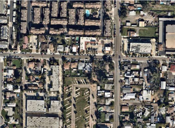
Initial Study Checklist/Environmental Checklist Form

   •   Retail Component/Rental of Moving Trucks: The project would include an office retail
       component within Building A that would sell packing and moving supplies and offer
       U-Haul or similar truck rental services.

   •   Loading and Unloading Areas: For the ground-based storage units, loading would
       typically take place from the designated loading area in front of the unit itself. For the
       interior units, the loading and unloading would take place in the areas close to the
       main hallways and the elevators. It is expected that the facility would have
       approximately six or seven customers on-site at any given time, and based on
       experience with similar storage facilities there would not be very much vehicular
       activity on the site at any time.

   •   Perimeter Fencing: The entire property would be surrounded by perimeter fencing.
       The project would construct wrought iron fences, approximately 75 inches in height,
       along the southern and western property boundaries. The project would also construct
       decorative masonry block wall fences with a minimum height of six feet adjacent to
       all existing residential land uses located north and east of the project site.

   •   Security Lighting and Cameras: The project site would be well lit to provide
       convenience and security at any time of day. The project would install wall packs on
       the buildings to provide both security and path of travel lighting for vehicles and
       pedestrians using the aisles between buildings and to access individual storage units.
       The RV and vehicle storage lot and rental parking area would be lit by pole lights. All
       project lighting would be implemented consistent with applicable security and
       municipal code requirements. A minimum of 20 security cameras with on-site and
       off-site monitoring features would also be installed throughout the facility.

9. Project Site Existing Conditions and Surrounding Land Use(s)

The 3.0-acre project site is currently undeveloped and consists entirely of Urban/Developed
Land composed of pavement and ornamental vegetation with no native habitat present. The
majority of non-paved areas consist primarily of non-native grasses with occasional trees.
The topography of the project area is relatively flat with an average elevation of 350 feet
above mean sea level. Based on historic aerial photographs, a portion of the project site was
occupied by a residence in 1953. By 1964, the parcel had been developed as a portion of a
mobile home park that continued in this configuration until 2010, by which time all of the
homes had been removed. The 2010 photograph also shows the same basic condition as is
currently found on the project site (Nationwide Environmental Title Research LLC 2020). As
shown on Figure 3, land uses surrounding the project site include single-family residences to
the north, single-family residences and a commercial structure to the east, SR-52 to the
south, and a business park with commercial/industrial uses to the west. Residential uses are
also located further west of the project site beyond the business park adjacent to the western
property boundary, as well as further north across Buena Vista Avenue. The commercial
structure to the east is approximately 28 feet in height, while the business park with
commercial/industrial uses to the west is approximately 18 feet in height. Although slightly
taller, the project’s proposed maximum height of 39 feet would be similar to these
surrounding uses.

                                  All Right Self-Storage Project
                                             Page 3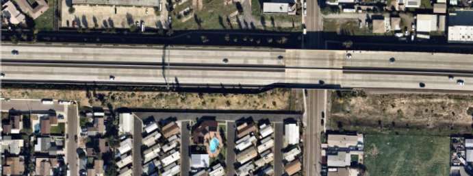
Initial Study Checklist/Environmental Checklist Form

10. Other Required Agency Approvals or Permits Required

General Construction Permit (San Diego Regional Water Quality Control Board)

11. Have California Native American tribes traditionally and culturally affiliated
    with the project area requested consultation pursuant to Public Resources
    Code Section 21080.3.1? If so, is there a plan for consultation that includes, for
    example, the determination of significance of impacts to tribal cultural
    resources, procedures regarding confidentiality, etc.?
In accordance with Assembly Bill (AB) 52, the Native American Heritage
Commission (NAHC) was notified of the project on February 5, 2020 and the appropriate
local tribes were notified of the project on August 27, 2020. On February 21, 2020, the NAHC
indicated that results of a record search of the NAHC Sacred Lands File (SLF) were positive.
As requested, the City of Santee (City) contacted the Kumeyaay Cultural Repatriation
Committee (KCRC) and notified 13 Native American tribes that were provided by the NAHC
to inform them of the proposed project and to request additional information of cultural
resources on the project site or in the area. The City did not receive responses regarding
cultural resources present on the project site or near the site. However, the City received a
response from the San Pasqual Band of Mission Indians requesting a Kumeyaay monitor
present during grading activities.

The City received a response regarding the AB 52 notice from the Jamul Indian Village
requesting a Kumeyaay approved tribal cultural monitor and requesting that the Kumeyaay
approved cultural monitor and a qualified archaeologist evaluate discovered cultural
resources together. These requests are included in Mitigation Measures CUL-1 and CUL-2.

Review of Figure 6-2 of the General Plan Conservation Element determined that the project
site is not located within an area identified as having moderate potential for register eligible
archaeological sites. However, as described in Sections 15.5.b and 15.5.c below, project
construction would have the potential to encounter unknown buried archaeological deposits
and human remains. These would be considered significant impacts. Implementation of
Mitigation Measures CUL-1 through CUL-3 would ensure that any unknown cultural or
tribal cultural resources or human remains discovered during project related ground
disturbing activities would be properly identified and protected over the long term.
Implementation of Mitigation Measures CUL-1 through CUL-3 would reduce impacts on
unknown tribal cultural resources to a level less than significant.

12. Statement of Environmental Findings
An Initial Study was prepared by the City to evaluate the potential effects of the project on
the environment. As Lead Agency under the California Environmental Quality Act (CEQA)
and based on the finding contained in the attached Initial Study, the City has determined
that the project would not have a significant effect upon the environment with
implementation of the proposed mitigation measures.

The City also finds that the Initial Study reflects the City’s independent judgement.

The location and custodian of the documents and any other materials which constitute the
record of proceedings upon which the City bases its determination to adopt this Mitigated

                                 All Right Self-Storage Project
                                            Page 4
Initial Study Checklist/Environmental Checklist Form

Negative Declaration are as follows: City of Santee, Department of Development Services,
10601 Magnolia Avenue, Santee, California.

13. Summary of Environmental Factors Potentially Affected

The environmental factors checked below would be potentially affected by this project,
involving at least one impact that is a “Potentially Significant Impact” as indicated by the
checklist on the following pages.

       Aesthetics                           Agriculture and Forestry        Air Quality
                                            Resources
       Biological Resources                 Cultural Resources              Energy
       Geology/Soils                        Greenhouse Gas Emissions        Hazards &
                                                                            Hazardous Materials
       Hydrology/Water Quality              Land Use/Planning               Mineral Resources
       Noise                                Population/Housing              Public Services
       Recreation                           Transportation                  Tribal Cultural
                                                                            Resources
       Utilities/Service Systems            Wildfire                        Mandatory Findings
                                                                            of Significance

14. Determination

   I find that the proposed project COULD NOT have a significant effect on the
   environment, and a NEGATIVE DECLARATION will be prepared.
   I find that although the proposed project could have a significant effect on the
   environment, there will not be a significant effect in this case because the
                                                                                             X
   mitigation measures described on an attached sheet have been added to the
   project. A MITIGATED NEGATIVE DECLARATION will be prepared.
   I find that the proposed project MAY have a significant effect on the
   environment, and an ENVIRONMENTAL IMPACT REPORT is required.
   I find that the proposed project MAY have a significant effect(s) on the
   environment, but at least one effect (1) has been adequately analyzed in an
   earlier document pursuant to applicable legal standards, and (2) has been
   addressed by mitigation measures based on the earlier analysis as described on
   attached sheets, if the effect is a “potentially significant impact” or “potentially
   significant unless mitigated.” An ENVIRONMENTAL IMPACT REPORT is
   required, but it must analyze only the effects that remain to be addressed.
   I find that although the proposed project could have a significant effect on the
   environment, there WILL NOT be a significant effect in this case because all
   potentially significant effects (a) have been analyzed adequately in an earlier
   ENVIRONMENTAL IMPACT REPORT or NEGATIVE DECLARATION
   pursuant to applicable standards and (b) have been avoided or mitigated pursuant
   to that earlier ENVIRONMENTAL IMPACT REPORT or NEGATIVE
   DECLARATION, including revisions or mitigation measures that are imposed
   upon the proposed project, and nothing further is required

                                   All Right Self-Storage Project
                                              Page 5
Cle ve lan d
San Marcos Escondido NF
k
e
r e
Carlsbad V
U
78 C
ek
nt a l
Batiquitos Lagoon
C
r e §
¦
¨
15 S a Y s a b e
Lake Hodges
o
i d
n d
c o
E s
Encinitas e r
R i v
t o
Ramona
i
u
Rancho
g
S A N D I E G O
ie
Santa Fe
C O U N T Y
D
n
a
Solana
S
Fairbanks Ranch
Beach
Poway
Del Mar
Barona
U
V
56 Lo s P en a sq uito s
Ca ny on P re sv Reservation
San Vicente
Reservoir
§
¦5
¨ USMC AIR
STATION
MIRAMAR Ri ve r
o
g
ie
S a n D
San Diego Santee V
U
67
Lakeside
§
¦8
¨
U
V
52 Winter Gardens
Mis sio n Tr ails
Re gio n al P a rk j
k Bostonia Harbison
Canyon
U
V
163
El Cajon Granite Hills Crest
Sycuan
U
V 125
Reservation
La Mesa Casa de Rancho
Oro-Mount San Diego r
Helix e
iv
R
Lemon ate r
Spring Valley t w
Grove
ee
Jamul
V
U
94
w
La Presa Jamul Indian
S
Coronado Village
Sw eetw ater
V
U
75 Reservoir
National
City U
V
54
re
ek
Bonita C
a
u r
LOS ¨
§
¦
805
lz
SAN BERNARDINO D
u
ANGELES
Chula Vista Lower Otay
Reservoir
ORANGE RIVERSIDE
O
t
a
y
R i ve r
Imperial
SAN DIEGO Beach
U
V
905
O
MEXICO M E X I C
0 Miles 5 [
j
k Project Location
FIGURE 1
Regional Location
\\serverfs01\gis\JOBS5\9603\common_gis\fig1.mxd 2/13/2020 fmmMap Source: USGS 7.5 minute topographic map series, El Cajon quadrangle, 1994, El Cajon Land Grant
0 Feet 2,000 [
Project Location
FIGURE 2
Project Location on USGS Map
M:\JOBS5\9603\common_gis\fig2_USGS.mxd 2/10/2020 fmmImage Source: Nearmap (flown January 2020)
ASPE NGLO W PL
STARWO O D LN
BRI GHT CT
DAWN CT
DAYBREA K LN
BUE NA VISTA AVE
B U ENA VALLEY DR
CO TTONW OOD AVE
EL TORO LN
EL MATADO R LN
V
U52
AVIS LN
IAN WAY
0 Feet 200 [
Project Location
FIGURE 3
Project Location on Aerial Photograph
M:\JOBS5\9603\common_gis\fig3_aerial.mxd 2/10/2020 fmmMap Source: Jerry Cox Architect
FIGURE 4a
Phase I Site Plan
M:\JOBS5\9603\env\graphics\fig4a.ai 06/08/20 lbMap Source: WM SMITH ASSOCIATES
FIGURE 4b
Phase II Site Plan
M:\JOBS5\9603\env\graphics\fig4b.ai 02/21/2020 bmaMap Source: Urban Arena
REFERENCE NOTES SCHEDULE
SYMBOL DESCRIPTION
NOTES:
1. ALL SIDEWALKS IN CITY RIGHT-OF-WAY ADJACENT TO STREETS TO 1 PROPOSED DRIVEWAY
5. MAINTENANCE: ALL REQUIRED LANDSCAPE AREAS SHALL BE
BE NATURAL GRAY CONCRETE WITH BROOM FINISH. MAINTAINED BY OWNER. LANDSCAPE AND IRRIGATION AREAS IN THE
PUBLIC RIGHT-OF-WAY SHALL BE MAINTAINED BY OWNER. THE
2 ENTRY SIGN CONCEPT_PLANT_SCHEDULE TOTAL PLANTING AREA: 8,094 SQ FT
2. ALL ONSITE PAVING TO BE NATURAL GRAY CONCRETE WITH LANDSCAPE AREAS SHALL BE MAINTAINED FREE OF DEBRIS AND
BROOM FINISH. 3 SITE ENTRY BOTANICAL NAME COMMON NAME WUCOLS SIZING
LITTER, AND ALL PLANT MATERIAL SHALL BE MAINTAINED IN A
HEALTHLY GROWING CONDITION. DISEASED OR DEAD PLANT 4 AUTOMATED VEHICULAR ENTRY GATE PROPOSED TREES
3. ALL LANDSCAPED AREAS, EXCEPT TURF AREAS, TO RECEIVE A 3" MATERIAL SHALL BE SATISFACTORILY TREATED OR REPLACED PER THE EVERGREEN & DECIDUOUS TREE W/ 20`-50` MATURE HT. - SUCH AS: 24" BOX MIN.
LAYER OF SHREDDED BARK MULCH. CONDITIONS OF THE PERMIT. 5 PEDESTRIAN ENTRY GATE ARBUTUS UNEDO STRAWBERRY TREE L
1 ACACIA STENOPHYLLA SHOESTRING ACACIA L
4. LANDSCAPED AREAS WITHIN THE PROJECT SHALL RECEIVE A FULLY 6. MINIMUM TREE / IMPROVEMENT SEPARATION DISTANCE: TRAFFIC 6 ADA RAMP KOELREUTERIA PANICULATA GOLDEN RAIN TREE L
AUTOMATIC IRRIGATION SYSTEM THAT PROVIDES 100% COVERAGE SIGNALS / STOP SIGN - 20 FEET; UNDERGROUND UTILITY LINES - 5
TO ALL PROPOSED PLANTING AREAS. THE IRRIGATION SYSTEM SHALL LOPHOSTEMON CONFERTUS BRISBANE BOX M
FEET (10' FOR SEWER); ABOVE GROUND UTILITY STRUCTURES - 10 7 CONCRETE PEDESTRIAN WALKWAY PODOCARPUS GRACILIOR
BE ZONED ACCORDING TO PLANT TYPES, SOLAR EXPOSURE, SLOPE FERN PINE M
FEET; DRIVEWAYS - 10 FEET, INTERSECTIONS (INTERSECTING CURB QUERCUS AGRIFOLIA COAST LIVE OAK VL
RATIO, AND TYPE OF SPRINKLER HEAD TO BE USED. DRIP AND LOW LINES OF TWO STREETS)- 25 FEET. 8 RV AND BOAT STORAGE 2 RHUS LANCEA AFRICAN SUMAC L
PRECIPITATION RATE SPRINKLER HEADS SHALL BE USED WHERE
APPLICABLE TO ENCOURAGE WATER INFILTRATION INTO THE SOIL 9 3
TRASH ENCLOSURE
AND DECREASE WATER RUN-OFF. THE DESIGN OF THE SYSTEM
SHALL PROVIDE ADEQUATE SUPPORT FOR THE VEGETATION 10 MODULAR WETLAND SYSTEM PROPOSED SHRUBS AND GROUNDCOVER SHRUBS
SELECTED. ABELIA X GRANDIFLORA GLOSSY ABELIA M 60% @ 5 GAL 36" O.C.
11 EXISTING 6` HIGH CHAINLINK FENCE TO REMAIN - PROTECT IN PLACE 40% @ 1 GAL 24" O.C.
AGAVE X SPECIES AGAVE L
12 ALOE X SPECIES ALOE L
PROPOSED 6` HIGH CHAINLINK FENCE
12 ARBUTUS UNEDO COMPACTA STRAWBERRY TREE 'COMPACTA' L
13 PARKING AREA BACCHARIS PILULARIS 'PIGEON PT' DWARF COYOTE BUSH L
CAREX PRAEGRACILIS CALIFORNIA FIELD SEDGE M GROUNDCOVER
14 STAIRCASE ACCESS CAREX TUMULICOLA BERKELEY SEDGE L 100% @ 1GAL
14 30" O.C. MIN.
CARISSA MACROCARPA `GREEN CARPET` GREEN CARPET NATAL PLUM L
DIANELLA TASMANICA `TAS RED` FLAX LILY L
12 13 12 DIETES IRIDIOIDES WHITE FORTNIGHT LILY L
ECHEVERIA X SPECIES ECHEVERIA L
7 12 8 7 LIGUSTRUM JAPONICUM `TEXANUM` WAX LEAF PRIVET M
9 PENNISETUM 'FAIRY TAILS' EVERGREEN FOUNTAIN GRASS M
5 5
PHORMIUM TENAX NEW ZEALAND FLAX L
4 RHAPHIOLEPIS INDICA SPECIES INDIAN HAWTHORNE L
ROSMARINUS OFFICINALIS HUNTINGTON CARPET ROSEMARY VL
TRACHELOSPERMUM JASMINOIDES `STAR` STAR JASMINE M
7
6 LANDSCAPE CALCULATIONS
TOTAL PARKING AREA: 75,295 SQ FT
5 REQUIRED PLANTING (10%): 7,529 SQ FT
PLANTING AREA ADJACENT PARKING: 3,973 SQ FT
4
11
12
10 12
12
FIGURE 5a
Phase I Landscape Concept Plan
M:\JOBS5\9603\env\graphics\fig5a.ai 02/21/2020 bmaMap Source: Urban Arena
REFERENCE NOTES SCHEDULE
SYMBOL DESCRIPTION
NOTES:
1. ALL SIDEWALKS IN CITY RIGHT-OF-WAY ADJACENT TO STREETS TO 1 PROPOSED DRIVEWAY
5. MAINTENANCE: ALL REQUIRED LANDSCAPE AREAS SHALL BE
BE NATURAL GRAY CONCRETE WITH BROOM FINISH. MAINTAINED BY OWNER. LANDSCAPE AND IRRIGATION AREAS IN THE
PUBLIC RIGHT-OF-WAY SHALL BE MAINTAINED BY OWNER. THE
2 ENTRY SIGN CONCEPT_PLANT_SCHEDULE TOTAL PLANTING AREA: 8,176 SQ FT
2. ALL ONSITE PAVING TO BE NATURAL GRAY CONCRETE WITH LANDSCAPE AREAS SHALL BE MAINTAINED FREE OF DEBRIS AND
BROOM FINISH. 3 SITE ENTRY BOTANICAL NAME COMMON NAME WUCOLS SIZING
LITTER, AND ALL PLANT MATERIAL SHALL BE MAINTAINED IN A
HEALTHLY GROWING CONDITION. DISEASED OR DEAD PLANT 4 AUTOMATED VEHICULAR ENTRY GATE PROPOSED TREES
3. ALL LANDSCAPED AREAS, EXCEPT TURF AREAS, TO RECEIVE A 3" MATERIAL SHALL BE SATISFACTORILY TREATED OR REPLACED PER THE EVERGREEN & DECIDUOUS TREE W/ 20`-50` MATURE HT. - SUCH AS: 24" BOX MIN.
LAYER OF SHREDDED BARK MULCH. CONDITIONS OF THE PERMIT. 5 PEDESTRIAN ENTRY GATE ARBUTUS UNEDO STRAWBERRY TREE L
1 ACACIA STENOPHYLLA SHOESTRING ACACIA L
4. LANDSCAPED AREAS WITHIN THE PROJECT SHALL RECEIVE A FULLY 6. MINIMUM TREE / IMPROVEMENT SEPARATION DISTANCE: TRAFFIC 6 ADA RAMP KOELREUTERIA PANICULATA GOLDEN RAIN TREE L
AUTOMATIC IRRIGATION SYSTEM THAT PROVIDES 100% COVERAGE SIGNALS / STOP SIGN - 20 FEET; UNDERGROUND UTILITY LINES - 5
TO ALL PROPOSED PLANTING AREAS. THE IRRIGATION SYSTEM SHALL LOPHOSTEMON CONFERTUS BRISBANE BOX M
FEET (10' FOR SEWER); ABOVE GROUND UTILITY STRUCTURES - 10 7 CONCRETE PEDESTRIAN WALKWAY PODOCARPUS GRACILIOR
BE ZONED ACCORDING TO PLANT TYPES, SOLAR EXPOSURE, SLOPE FERN PINE M
FEET; DRIVEWAYS - 10 FEET, INTERSECTIONS (INTERSECTING CURB QUERCUS AGRIFOLIA COAST LIVE OAK VL
RATIO, AND TYPE OF SPRINKLER HEAD TO BE USED. DRIP AND LOW LINES OF TWO STREETS)- 25 FEET. 8 RV AND BOAT STORAGE 2 RHUS LANCEA AFRICAN SUMAC L
PRECIPITATION RATE SPRINKLER HEADS SHALL BE USED WHERE
APPLICABLE TO ENCOURAGE WATER INFILTRATION INTO THE SOIL 9 TRASH ENCLOSURE
AND DECREASE WATER RUN-OFF. THE DESIGN OF THE SYSTEM
SHALL PROVIDE ADEQUATE SUPPORT FOR THE VEGETATION 10 MODULAR WETLAND SYSTEM 3 SHRUBS
PROPOSED SHRUBS AND GROUNDCOVER
SELECTED. ABELIA X GRANDIFLORA GLOSSY ABELIA M 60% @ 5 GAL 36" O.C.
11 EXISTING 6` HIGH CHAINLINK FENCE TO REMAIN - PROTECT IN PLACE 40% @ 1 GAL 24" O.C.
AGAVE X SPECIES AGAVE L
12 ALOE X SPECIES ALOE L
PROPOSED 6` HIGH CHAINLINK FENCE
12 ARBUTUS UNEDO COMPACTA STRAWBERRY TREE 'COMPACTA' L
13 PARKING AREA BACCHARIS PILULARIS 'PIGEON PT' DWARF COYOTE BUSH L
CAREX PRAEGRACILIS CALIFORNIA FIELD SEDGE M GROUNDCOVER
14 STAIRCASE ACCESS CAREX TUMULICOLA BERKELEY SEDGE L 100% @ 1GAL
14 30" O.C. MIN.
CARISSA MACROCARPA `GREEN CARPET` GREEN CARPET NATAL PLUM L
DIANELLA TASMANICA `TAS RED` FLAX LILY L
12 12 DIETES IRIDIOIDES WHITE FORTNIGHT LILY L
ECHEVERIA X SPECIES ECHEVERIA L
7 12 13 7 LIGUSTRUM JAPONICUM `TEXANUM` WAX LEAF PRIVET M
9 PENNISETUM 'FAIRY TAILS' EVERGREEN FOUNTAIN GRASS M
5 5
PHORMIUM TENAX NEW ZEALAND FLAX L
4 RHAPHIOLEPIS INDICA SPECIES INDIAN HAWTHORNE L
ROSMARINUS OFFICINALIS HUNTINGTON CARPET ROSEMARY VL
TRACHELOSPERMUM JASMINOIDES `STAR` STAR JASMINE M
7
6 LANDSCAPE CALCULATIONS
TOTAL PARKING AREA: 22,912 SQ FT
5 REQUIRED PLANTING (10%): 2,291 SQ FT
PLANTING AREA ADJACENT PARKING: 4,062 SQ FT
4
11
12
10 12
12
FIGURE 5b
Phase II Landscape Concept Plan
M:\JOBS5\9603\env\graphics\fig5b.ai 02/21/2020 bmaInitial Study Checklist/Environmental Checklist Form
15. Environmental Checklist Form
EVALUATION OF ENVIRONMENTAL IMPACTS:
1. A brief explanation is required for all answers except “No Impact” answers that are
adequately supported by the information sources a lead agency cites in the parentheses
following each question. A “No Impact” answer is adequately supported if the referenced
information sources show that the impact simply does not apply to projects like the one
involved (e.g., the project falls outside a fault rupture zone). A “No Impact” answer should
be explained where it is based on project-specific factors as well as general standards (e.g.,
the project will not expose sensitive receptors to pollutants, based on a project-specific
screening analysis).
2. All answers must take account of the whole action involved, including off-site as well as
on-site, cumulative as well as project-level, indirect as well as direct, and construction as
well as operational impacts.
3. Once the lead agency has determined that a particular physical impact may occur, then
the checklist answers must indicate whether the impact is potentially significant, less
than significant with mitigation, or less than significant. “Potentially Significant Impact”
is appropriate if there is substantial evidence that an effect may be significant. If there
are one or more “Potentially Significant Impact” entries when the determination is made,
an Environmental Impact Report is required.
4. “Negative Declaration: Less Than Significant With Mitigation Incorporated” applies
where the incorporation of mitigation measures has reduced an effect from “Potentially
Significant Impact” to a “Less Than Significant Impact.” The lead agency must describe
the mitigation measures, and briefly explain how they reduce the effect to a less than
significant level (mitigation measures from “Earlier Analyses,” as described in (5) below,
may be cross-referenced).
5. Earlier analyses may be used where, pursuant to the tiering, program Environmental
Impact Report, or other CEQA process, an effect has been adequately analyzed in an
earlier Environmental Impact Report or negative declaration. Section 15063(c)(3)(D). In
this case, a brief discussion should identify the following:
a. Earlier Analysis Used. Identify and state where they are available for review.
b. Impacts Adequately Addressed. Identify which effects from the above checklist were
within the scope of and adequately analyzed in an earlier document pursuant to
applicable legal standards, and state whether such effects were addressed by
mitigation measures based on the earlier analysis.
c. Mitigation Measures. For effects that are “Less than Significant with Mitigation
Measures Incorporated,” describe the mitigation measures which were incorporated
or refined from the earlier document and the extent to which they address site-specific
conditions for the project.
All Right Self-Storage Project
Page 14Initial Study Checklist/Environmental Checklist Form
6. Lead agencies are encouraged to incorporate into the checklist references to information
sources for potential impacts (e.g., general plans, zoning ordinances). Reference to a
previously prepared or outside document should, where appropriate, include a reference
to the page or pages where the statement is substantiated.
7. Supporting Information Sources: A source list should be attached, and other sources used
or individuals contacted should be cited in the discussion.
8. This is only a suggested form, and lead agencies are free to use different formats; however,
lead agencies should normally address the questions from this checklist that are relevant
to a project's environmental effects in whatever format is selected.
9. The explanation of each issue should identify:
a. the significance criteria or threshold, if any, used to evaluate each question; and
b. the mitigation measure identified, if any, to reduce the impact to less than
significance.
All Right Self-Storage Project
Page 15Initial Study Checklist/Environmental Checklist Form
15.1 Aesthetics
Would the project:
Less Than
Potentially Significant Less Than
Significant with Significant No
Issue Impact Mitigation Impact Impact
a. Have a substantial adverse effect
on a scenic vista?
b. Substantially damage scenic
resources, including but not
limited to, trees, rock
outcroppings, and historic
buildings within a state scenic
highway?
c. Substantially degrade the existing
visual character or quality of
public views of the site and its
surroundings? (Public views are
those that are experienced from a
publicly accessible vantage point).
If the project is in an urbanized
area, would the project conflict
with applicable zoning and other
regulations governing scenic
quality?
d. Create a new source of substantial
light or glare that would adversely
affect day or nighttime views in
the area?
Sources: Project Plans; City of Santee General Plan (Conservation, Community
Enhancement, and Circulation Elements); Santee Municipal Code.
a. No Impact. The City General Plan identifies existing visual resources including the San
Diego River and other waterway corridors, undeveloped hillsides and ridgelines, the Santee
Town Center, Santee Lakes and Mission Trails Regional Parks, and the San Diego Trolley.
The project site is not located adjacent to any of these visual resources, nor are there views
of any of these sites from the property. The project site is located within an urbanized
environment and is surrounded by commercial, commercial/industrial, residential, and
roadway uses. Additionally, the project site is not designated as open space, nor does it
possess views of any areas designated as open space. Therefore, the project would not have a
substantial adverse effect on a scenic vista. No impact would occur.
b. No Impact. There are no designated state scenic highways within Santee. The eastern
terminus of the segment of SR-52 that is designated as a state scenic highway (Santo Road
to Mast Boulevard) is located in the City of San Diego, approximately 3.1 miles to the
northwest, and as is not visible from the property. The project site does not possess any scenic
All Right Self-Storage Project
Page 16Initial Study Checklist/Environmental Checklist Form
resources such as trees and rock outcroppings and is unremarkable in character. As described
in Section 15.5.a below, there are no historic resources located on the project site. Therefore,
the project would not substantially damage any scenic resources within a state scenic
highway. No impact would occur.
c. Less Than Significant Impact. The project site is located within an urbanized
environment consisting of commercial, commercial/industrial, and residential uses located
near SR-52. The project site is currently undeveloped and consists primarily of non-native
grasses with occasional trees. A small amount of paved areas exists on the project site that
are associated with the previous uses as mobile home park. However, all mobile homes were
removed in 2010, and there are currently no structures on the project site.
The project would be consistent with the existing visual character because it would construct
a commercial facility within an area that currently consists of a mix of commercial,
commercial/industrial, and residential uses. The surrounding residential uses are currently
situated adjacent to other commercial and commercial/uses. Therefore, adding another
commercial use would be consistent with the existing mix of uses within the community. The
commercial structure to the east is approximately 28 feet in height, while the business park
with commercial/industrial uses to the west is approximately 18 feet in height. Although
slightly taller, the project’s proposed maximum height of 39 feet would be similar to these
surrounding uses. The project consists of five separate structures that have been designed
consistent with the applicable setback requirements from both the property line and other
project buildings. Consequently, all five buildings would avoid massing and be consistent
with the bulk and scale of the surrounding uses. The project has also been designed with and
will comply with applicable zoning regulations pertaining to scenic quality and would include
landscaping to enhance the visual quality of the project site. Therefore, the project would not
substantially degrade the existing visual character or quality of the site and its surroundings,
and impacts would be less than significant.
d. Less Than Significant Impact. Project construction would be limited to the City’s
allowable construction hours of 7:00 a.m. and 7:00 p.m. and is not anticipated to require
lighting. In the event that construction lighting is required, it would be properly shielded to
avoid spillover effects. The project would not include large uninterrupted expanses of glass
or any other highly reflective material that could generate glare during the daytime.
Although the project would introduce solar panels, these are designed to absorb light rather
than reflect it, and the solar panels would be coated with anti-reflective materials to
maximize light absorption. Furthermore, the proposed solar panels would be mounted on the
roof facing upwards and would not reflect light towards adjacent uses.
The project would include outdoor lighting typical of commercial uses. The project would
install wall packs on the buildings to provide both security and path of travel lighting for
vehicles and pedestrians using the aisles between buildings and to access individual storage
units. The RV and vehicle storage lot and rental parking area would be lit by pole lights.
Light spillover, trespass, and potential glare from project lighting are regulated by Section
13.30.030(B) of the Santee Municipal Code. The code requires that all lights and illuminated
signs must be designed and adjusted to reflect light away from any road or street, away from
All Right Self-Storage Project
Page 17Initial Study Checklist/Environmental Checklist Form
any adjoining premises, and shall be shielded or directed to not cause glare on adjacent
properties or motorists. Project lighting would be designed consistent with the requirements
of the Santee Municipal Code. The project would prepare a Photometric Light Study as a
conditional of approval that would document how the design would shield and direct all
illumination in a manner that would prevent spillover, trespass, and glare on adjacent
properties. Light associated with additional vehicle trips generated by the project would be
similar in character to what is currently generated by vehicles traveling along the existing
roadway network after dark. Therefore, the project would not create a new source of
substantial light or glare that would adversely affect day or nighttime views in the area, and
impacts would be less than significant.
15.2 Agriculture Resources
In determining whether impacts to agricultural resources are significant environmental
effects, lead agencies may refer to the California Agricultural Land Evaluation and City
Assessment Model (1997) prepared by the California Department of Conservation as an
optional model to use in assessing impacts on agricultural land and farmland. Would the
project:
Less Than
Potentially Significant Less Than
Significant with Significant No
Issue Impact Mitigation Impact Impact
a. Convert Prime Farmland, Unique
Farmland, or Farmland of
Statewide Importance (Farmland),
as shown on the maps prepared
pursuant to the Farmland Mapping
and Monitoring Program of the
California Resources Agency, to
non-agricultural use?
b. Conflict with existing zoning for
agricultural use, or a Williamson
Act Contract?
c. Conflict with existing zoning for, or
cause rezoning of, forest land (as
defined in Public Resources Code
Section 12220[g]), timberland (as
defined by Public Resources Code
Section 4526), or timberland zoned
Timberland Production (as defined
by Government Code Section
51104[g])?
d. Result in the loss of forest land or
conversion of forest land to non-
forest use?
All Right Self-Storage Project
Page 18Initial Study Checklist/Environmental Checklist Form
Less Than
Potentially Significant Less Than
Significant with Significant No
Issue Impact Mitigation Impact Impact
e. Involve other changes in the
existing environment, which, due to
their location or nature, could
result in conversion of Farmland to
non-agricultural use or conversion
of forest land to non-forest use?
Sources: City of Santee General Plan–Land Use Element; City of Santee Zoning Ordinance;
Department of Conservation–Farmland Mapping and Monitoring Program; Department of
Conservation–Land Conservation Act Maps.
a. No Impact. The project site and surrounding properties are not identified as Prime
Farmland, Unique Farmland, or Farmland of Statewide Importance. The Farmland Mapping
and Monitoring Program classifies the project site and surrounding properties as “Urban and
Built Up Land” (California Department of Conservation 2016). No impact would occur.
b. No Impact. The project site and surrounding properties are not zoned for agricultural
uses and are not subject to a Williamson Act contract. No impact would occur.
c. No Impact. The project site does not contain any forest or timberland as defined by Public
Resources Code Section 12220[g], Public Resources Code Section 4526, or Government Code
Section 51104(g) and is not zoned as forest or timberland. No impact would occur.
d. No Impact. The project site does not contain any forest or timberland as defined by Public
Resources Code Section 12220[g], Public Resources Code Section 4526, or Government Code
Section 51104(g). No impact would occur.
e. No Impact. Surrounding land uses include single-family residences to the north, single-
family residences and a commercial structure to the east, SR-52 to the south, and a Business
Park consisting of commercial/industrial uses to the west. There are no agricultural uses or
forestlands on-site or in the vicinity of the project site. Therefore, the project would not result
in conversion of farmland or forest land. No impact would occur.
All Right Self-Storage Project
Page 19Initial Study Checklist/Environmental Checklist Form
15.3 Air Quality
Where available, the significance criteria established by the applicable air quality
management or air pollution control district may be relied upon to make the following
determinations. Would the project:
Less Than
Potentially Significant Less Than
Significant with Significant No
Issue Impact Mitigation Impact Impact
a. Conflict with or obstruct
implementation of the applicable
air quality plan?
b. Result in a cumulatively
considerable net increase of any
criteria pollutant for which the
project region is non-attainment
under an applicable federal or state
ambient air quality standard?
c. Expose sensitive receptors to
substantial pollutant
concentrations?
d. Result in other emissions such as
those leading to odors adversely
affecting a substantial number of
people?
Sources: Project Description, City of Santee General Plan–Land Use Element; Air Quality
Model Results (California Emissions Estimator Model [CalEEMod] Output Files) prepared
by RECON Environmental, Inc. (August 20, 2020, Appendix A); San Diego Air Pollution
Control District (SDAPCD) Rules 20.1, 20.2, 20.3 (SDAPCD 2016); Office of Environmental
Health Hazard Assessment (OEHHA) Air Toxics Hot Spots Program Guidance Manual for
the Preparation of Risk Assessments (OEHHA 2015); California Air Resources Board (CARB)
Air Quality and Land Use Handbook (CARB 2005); and University of California, Davis
Institute of Transportation Studies Transportation Project-Level Carbon Monoxide Protocol
(U.C. Davis Institute of Transportation Studies 1997).
a. Less than Significant Impact. Following the California Clean Air Act, California was
divided geographically into 15 air basins for managing the state air resources on a regional
basis. Areas within each air basin are considered to share the same air masses and, therefore,
have similar ambient air quality. The project site is located within the San Diego Air
Basin (SDAB). Stationary sources of air emissions within each air basin are regulated by
regional air quality districts, of which the project is located within the jurisdiction of the
SDAPCD.
Air districts are tasked with regulating emissions such that air quality in the basin does not
exceed national or California ambient air quality standards (NAAQS and CAAQS); where
NAAQS and CAAQS represent the maximum levels of background pollution considered safe,
with an adequate margin of safety, to protect the public health and welfare. NAAQS and
All Right Self-Storage Project
Page 20Initial Study Checklist/Environmental Checklist Form
CAAQS have been established for six common pollutants of concern known as criteria
pollutants, which include ozone (O3), carbon monoxide (CO), sulfur dioxide (SO2), nitrogen
dioxide (NO2), lead (Pb), and respirable particulate matter (particulate matter less than 10
microns [PM10] and less than 2.5 microns [PM2.5]).
The SDAB is currently classified as a federal and state non-attainment area for ozone, and
as a state non-attainment area for PM10, and PM2.5. The SDAPCD prepared an air quality
plan, the 2016 Regional Air Quality Strategy (RAQS), to identify feasible emission control
measures intended to progress toward attaining NAAQS and CAAQS for ozone. Reducing
ozone concentrations is achieved by reducing the precursors to the photochemical formation
of ozone (volatile organic compounds and oxides of nitrogen [NOX]).
The growth forecasting for the RAQS is based in part on the land uses established by local
general plans. Thus, if a project is consistent with land use designated in the local general
plan, it can normally be considered consistent with the RAQS. Projects that propose a
different land use than is identified in the local general plan may also be considered
consistent with the RAQS if the proposed land use is less intensive than the current land use
designation. For projects that propose a land use that is more intensive than the current
zoning designation, detailed analysis is required to assess conformance with the RAQS.
The project site is currently designated and zoned as Light Industrial (IL). The project would
be consistent with the existing land use and zoning designations for the project site, and
therefore would be consistent with the growth assumptions of the General Plan. Additionally,
as discussed in Section 15.3.b below, project emissions would not exceed the project-level
significance thresholds. Therefore, the project would not result in an increase in emissions
that are not already accounted for in the RAQS, and impacts would be less than significant.
b. Less than Significant Impact. As discussed in Section 15.3.a above, NAAQS and
CAAQS have been established for six criteria pollutants (ozone, CO, SO2, NO2, lead, and
particulate matter). The City has not adopted air quality significance thresholds for these
pollutants, and the SDAPCD does not provide specific numeric thresholds for determining
the significance of air quality impacts under the CEQA Guidelines. However, the SDAPCD
does specify air quality impact analysis “trigger” levels for criteria pollutant emissions
associated with new or modified stationary sources (SDAPCD Rules 20.1, 20.2, and 20.3). The
SDAPCD does not consider these trigger levels to represent adverse air quality impacts;
rather, if these trigger levels are exceeded by stationary sources associated with a project,
the SDAPCD requires an air quality analysis to determine if a significant air quality impact
would occur. This analysis uses SDAPCD trigger levels shown in Table 1 as air quality impact
screening levels.
All Right Self-Storage Project
Page 21Initial Study Checklist/Environmental Checklist Form
Table 1
Air Quality Impact Analysis Trigger Levels
Emission Rate Emission Rate Emission Rate
Pollutant (pounds per hour) (pounds per day) (tons per year)
NOX 25 250 40
SOX 25 250 40
CO 100 550 100
PM10 -- 100 15
Lead -- 3.2 0.6
ROG1 -- 250 --
PM2.5 -- 67 10
SOURCE: SDAPCD, Rules 20.1, 20.2, 20.3 (SDAPCD 2016).
1 The reactive organic gases (ROG) threshold is based on federal General
Conformity de minimis levels for ozone precursors.
The project would result in short-term emissions from construction and long-term emissions
associated with project operation. Construction and operational emissions associated with
the project were modeled using CalEEMod version 2016.3.2 (see Appendix A), which
incorporates current air emission data. Planning methods, protocol, modeling methodology,
and assumptions are summarized below.
Construction Emissions
Construction-related activities are temporary, short-term sources of air emissions. Sources
of construction-related emissions include the following:
• fugitive dust from grading activities;
• equipment exhaust;
• off-gassing from architectural coatings (paints, etc.) and paving; and
• vehicle trips by workers, delivery trucks, and material-hauling trucks.
The project would be constructed in two phases. Each construction phase would last for
approximately 15 to 18 months, and there would be three to four years between the
completion of Phase I and the beginning of Phase II construction. Emissions were modeled
assuming each phase would require 18 months of construction activities and would occur
three years apart. This is the most conservative assumption because 18 months is the longer
anticipated construction duration and modeling a three-year gap between phases rather than
five years results in greater equipment emissions because construction equipment gets
cleaner over time due to CARB regulations.
Table 2 shows the total projected construction maximum daily emission levels for each
criteria pollutant. The CalEEMod output files for construction emissions for the project are
contained in Appendix A.
All Right Self-Storage Project
Page 22Initial Study Checklist/Environmental Checklist Form
Table 2
Summary of Maximum Build-out Construction Emissions
(pounds per day)
ROG NOX CO SOX PM10 PM2.5
Phase I
Site Preparation 4 41 22Initial Study Checklist/Environmental Checklist Form
(thereby replacing fleets with cleaner equipment), and requires that fleets comply with Best
Available Control Technology requirements.
Therefore, as project construction emissions would be well below these limits and the project
would implement standard construction measures in order to comply with SDAPCD rules
and regulations and CARB’s In-Use Off-Road Diesel-Fueled Fleets Regulation, construction
emissions would not result in regional emissions that would exceed the NAAQS or CAAQS
or contribute to existing violations. Therefore, construction of the project would not result in
a cumulatively considerable net increase of any criteria pollutant for which the project region
is non-attainment, and impacts would be less than significant.
Operational Emissions
Operation of the project would result in long-term emissions from mobile and area sources.
Mobile emissions were calculated based on the vehicle type and the trip rate for each land
use. Project trip generation rates for Phase 1 and Phase 2 were calculated using San Diego
Association of Governments (SANDAG) trip generation rates as well as a traffic study
prepared for a similar facility with RV storage. Table 3 summarizes the traffic generated by
the project.
Table 3
Project Trip Generation
Land Use Amount Trip Generation Rate Total Trips AM Peak PM Peak
Phase 1
Storage 87,613 square feet 2 trips/1,000 square feet1 175 11 16
RV and Boat Storage 57 spaces 0.022 trips/space2 1 0 0
Caretaker Unit 1 dwelling unit 6 trips/dwelling unit3 6 1 1
Total 182 12 17
Phase 2
Storage 146,528 square feet 2 trips/1,000 square feet1 293 18 27
RV and Boat Storage 0 spaces 0.022 trips/space2 0 0 0
Caretaker Unit 1 dwelling unit 6 trips/dwelling unit3 6 1 1
Total 299 19 28
1Trip rate obtained from SANDAG trip generation rates (SANDAG 2002)
2Trip rate obtained from the Transportation Access Analysis for the Sun Ridge Vista RV/Mini Storage
Facility in the city of San Diego (LOS Engineering, Inc. 2019)
3The SANDAG trip generation rate for multi-family residential uses was assumed for the caretaker unit
(SANDAG 2002).
As described above, construction of each phase is anticipated to last 15 to 18 months, and
there would be three to four years between phases. For calculating operational emissions,
Phase I was assumed to be operational in year 2022 and Phase II was assumed to be
operational in 2027. Based on regional data compiled by CARB as part of Emission Factors
2017 model, the average regional trip length for all trips in San Diego County will be 7.48
miles in 2022 and 7.22 miles in 2027 (CARB 2017). Default vehicle emission factors were
used. Area emissions include emissions from the use of landscaping equipment, consumer
products (aerosols, cleansers, etc.), and architectural coatings (e.g., paint). Area sources were
calculated based on regional use factors.
All Right Self-Storage Project
Page 24You can also read


