Cherrywood SDZ Green Routes Network - Report to Inform the Environmental Impact Assessment Screening Dun Laoghaire-Rathdown County Council ...
←
→
Page content transcription
If your browser does not render page correctly, please read the page content below
Cherrywood SDZ Green
Routes Network
Report to Inform the Environmental Impact Assessment
Screening

Dun Laoghaire-Rathdown County Council

Project number: 60599677

March 2022
Cherrywood SDZ Green Routes Network
                                                                                                Project number: 60599677

Quality information
Prepared by                      Checked by                    Verified by                Approved by

Noelle O'Leary                   Shauna Woods                  Niamh Kennedy              Brian McMahon
Elaine Keenan

Environmental Consultant         Associate Director -          Associate Director         Associate Director
                                 Planning                      Environment and Planning

Revision History
Revision             Revision date         Details            Authorized        Name              Position

01                   01 February 2022      Issue of a Work in BMcM              Brian McMahon     Associate Director
                                           Progress Report
                                           incorporating client
                                           comments

02                   08 February 2022      Final Draft        BMcM              Brian McMahon     Associate Director

03                   16 February 2022      Update following   BMcM              Brian McMahon     Associate Director
                                           client comments

04                   14 March 2022         Final              BMcM              Brian McMahon     Associate Director

Distribution List
# Hard Copies        PDF Required          Association / Company Name

Prepared for: Dun Laoghaire-Rathdown County Council                                                             AECOM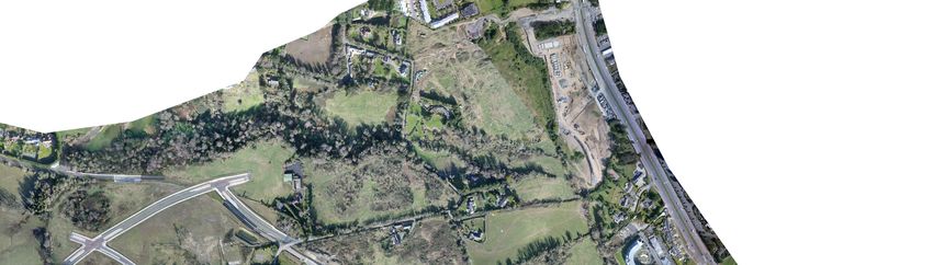
Cherrywood SDZ Green Routes Network
                                                                                        Project number: 60599677

Prepared for:
Dun Laoghaire-Rathdown County Council

Prepared by:
AECOM Ireland Limited
4th Floor
Adelphi Plaza
Georges Street Upper
Dun Laoghaire
Co. Dublin A96 T927
Ireland

T: +353 1 238 3100
aecom.com

.

© 2022 AECOM Ireland Limited. All Rights Reserved.

This document has been prepared by AECOM Ireland Limited (“AECOM”) for sole use of our client (the “Client”)
in accordance with generally accepted consultancy principles, the budget for fees and the terms of reference
agreed between AECOM and the Client. Any information provided by third parties and referred to herein has not
been checked or verified by AECOM, unless otherwise expressly stated in the document. No third party may rely
upon this document without the prior and express written agreement of AECOM.

Prepared for: Dun Laoghaire-Rathdown County Council                                                     AECOM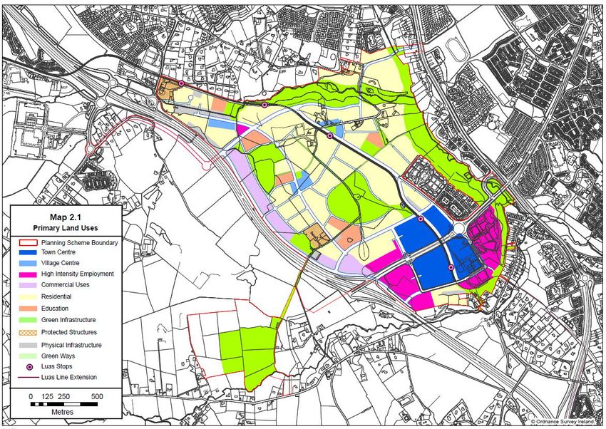
Cherrywood SDZ Green Routes Network
                                                                                                                                  Project number: 60599677

Table of Contents
1.      Introduction............................................................................................................................................ 1
        1.1       Background................................................................................................................................. 1
2.      Description of the Proposed Development .............................................................................................. 2
        2.1       Introduction ................................................................................................................................. 2
3.      EIA Screening Process........................................................................................................................... 3
        3.1       Introduction ................................................................................................................................. 3
        3.1.1 EIA Directive ............................................................................................................................... 3
        3.2       Legislation................................................................................................................................... 3
        3.2.1 Environmental Impact Assessment (EIA) ...................................................................................... 3
        3.2.2 Appropriate Assessment (AA) ...................................................................................................... 3
        3.3       Methodology ............................................................................................................................... 4
        3.3.1 Assumptions ............................................................................................................................... 5
        3.3.2 Legislative Grounds for an EIA..................................................................................................... 6
        3.3.2.1Planning and Development Regulation Screening ........................................................................ 6
        3.3.2.2Section 50, Roads Act 1993 (as amended) ................................................................................... 6
        3.3.3 Sub-Threshold Assessment ......................................................................................................... 7
        3.4       Characteristics of the Proposed Development .............................................................................. 8
        3.4.1 Size and Design of the Proposed Development ............................................................................ 8
        3.4.2 Cumulation with other Existing and / or Proposed Developments .................................................. 9
        3.4.3 Nature of any Associated Demolition Works ............................................................................... 10
        3.4.4 Use of Natural Resources, in Particular Land, Soil, Water and Biodiversity .................................. 10
        3.4.5 Production of Waste .................................................................................................................. 10
        3.4.6 Pollution and Nuisances ............................................................................................................ 10
        3.4.7 Risk of Accidents and / or Disasters Which are Relevant to the Project Concerned, Including Those
              Caused by Climate Change in Accordance with Scientific Knowledge ......................................... 11
        3.4.8 Utilities ...................................................................................................................................... 13
        3.4.9 Risks to Human Health .............................................................................................................. 13
        3.5       Location of the Proposed Development ...................................................................................... 14
        3.5.1 Existing and Approved Land-Use ............................................................................................... 14
        3.5.2 The Relative Abundance, Availability, Quality and Regenerative Capacity of Natural Resources in
              the Area (Land / Soil / Water and Biodiversity) ............................................................................ 16
        3.5.3 The Adsorption Capacity of the Natural Environment .................................................................. 17
        3.5.3.1Overview of the Site .................................................................................................................. 17
        3.5.3.2Wetlands, Riparian Areas and River Mouths............................................................................... 17
        3.5.3.3Costal Zones and the Marine Environment ................................................................................. 17
        3.5.3.4Mountain and Forest Parks ........................................................................................................ 17
        3.5.3.5Nature Reserves and Parks ....................................................................................................... 17
        3.5.3.6Areas classified or Protected Under Legislation, including Natura 2000 Areas Designated Pursuant
               to the Habitats Directive and the Birds Directive ......................................................................... 18
        3.5.3.7Areas in Which There Has Already Been A Failure to Meet the Environmental Quality Standards
               Laid Down in Legislation of the European Union and Relevant to the Project, or in Which It is
               Considered that there is Such a Failure...................................................................................... 19
        3.5.3.8Densely Populated Areas........................................................................................................... 19
        3.5.3.9Landscapes and Sites of Historical, Cultural or Archaeological Significance ................................ 20
        3.5.3.10       Landscape .......................................................................................................................... 22
        3.6       Type and Characteristics of Potential Impacts ............................................................................ 22
        3.6.1 Magnitude and Spatial Extent of the Impact................................................................................ 22
        3.6.2 The Nature of the Impact ........................................................................................................... 23
        3.6.2.1Population and Human Health ................................................................................................... 23
        3.6.2.2Water ........................................................................................................................................ 23

Prepared for: Dun Laoghaire-Rathdown County Council                                                                                                   AECOM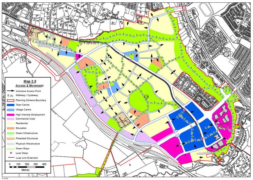
Cherrywood SDZ Green Routes Network
                                                                                                                                        Project number: 60599677

          3.6.2.3Land and Soils .......................................................................................................................... 24
          3.6.2.4Air Quality and Climate .............................................................................................................. 24
          3.6.2.5Noise and Vibration ................................................................................................................... 24
          3.6.2.6Cultural Heritage ....................................................................................................................... 25
          3.6.2.7Biodiversity ............................................................................................................................... 26
          3.6.2.8Landscape ................................................................................................................................ 29
          3.6.2.9Material Assets.......................................................................................................................... 30
          3.6.2.10         Waste ................................................................................................................................. 30
          3.6.3 The Transboundary Nature of the Impact ................................................................................... 31
          3.6.4 The Intensity and Complexity of the Impact ................................................................................ 31
          3.6.5 The Probability of the Impact ..................................................................................................... 31
          3.6.6 The Expected Onset, Duration, Frequency and Reversibility of the Impact .................................. 31
          3.6.7 The Possibility of effectively reducing the impact ........................................................................ 31
4.        Screening Conclusions and Recommendations..................................................................................... 32
5.        References .......................................................................................................................................... 34
Appendix A Screening Checklist ...................................................................................................................... 35
Appendix B Planning Application Search (2011 – 17/01/2022) .......................................................................... 40
Appendix C Drawings ..................................................................................................................................... 57

Figures
Figure 1-1 Proposed Development .................................................................................................................... 1
Figure 2-1 Route Sections along Scheme Route ................................................................................................ 2
Figure 3-1 Proposed Greenway Cross Section................................................................................................... 9
Figure 3-2 CFRAM Flood Map......................................................................................................................... 12
Figure 3-3 Map of Primary Land-Uses ............................................................................................................. 15
Figure 3-4 Cherrywood SDZ Access and Movement (Map 2.5 of the Cherrywood Planning Scheme) ................ 16
Figure 3-5 European Sites Within the Vicinity of the Proposed Development (Scott Cawley, 2022a) .................. 18
Figure 3-6 Natural Heritage Areas within the vicinity of the Proposed Development (Scott Cawley, 2022a)......... 19

Tables
Table 3-1 Mandatory Environmental Impact Assessment Criteria Established under the Planning and
Development Regulations ................................................................................................................................. 6
Table 3-2 Summary of the Mandatory Legislative Requirements for Environmental Impact Assessment (EIA)
Impact Screening under the Roads Act (as amended) ........................................................................................ 7
Table 3-3 Summary of the Sub-threshold Legislative Requirements for Environmental Impact Assessment
Screening ......................................................................................................................................................... 7
Table 3-4 Recorded Archaeological Sites ......................................................................................................... 20
Table 3-5 NIAH and Protected Structures......................................................................................................... 21
Table 3-6 Typical Allowable Vibration during Road Construction in Order to Minimise the Risk of Building Damage
 ...................................................................................................................................................................... 25

Prepared for: Dun Laoghaire-Rathdown County Council                                                                                                           AECOM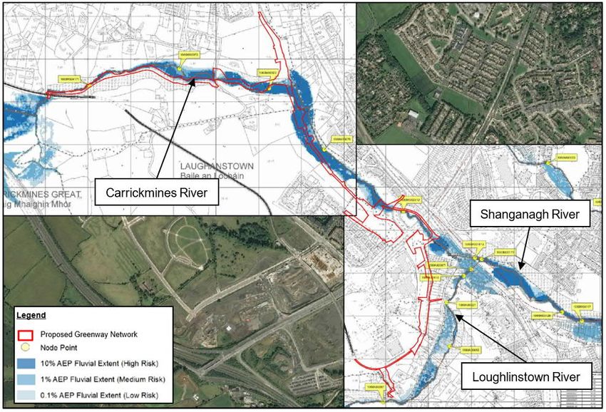
Cherrywood SDZ Green Routes Network
1. Introduction
1.1 Background
This report to inform the Environmental Impact Assessment (EIA) Screening Determination has been prepared on
behalf Dun Laoghaire-Rathdown County Council (hereafter referred to as the ‘Applicant’) to accompany their Part
8 Planning package for a greenway, cycle and pedestrian routes network for Cherrywood Strategic Development
Zone (SDZ) (hereafter referred to as the ‘Proposed Development’) in Cherrywood, Co. Dublin (here after referred
to as the ‘Proposed Development Site’).
This report sets out:
the screening methodology;
the scope of the Proposed Development; and
the Proposed Development’s potential to interact with the environment during the both the construction and
operational phases.
The purpose of the report is to inform the determination as to whether the Proposed Development requires an EIA.
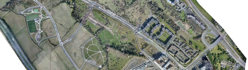
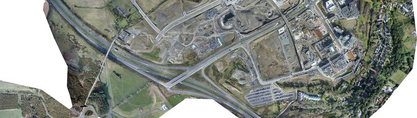
The Applicant is proposing to construct a circa (c.) 6.0km Greenway, Cycle and Pedestrian Routes Network for the
Cherrywood SDZ (refer to Figure 1-1). The objectives of the Proposed Development are to develop and design to
a detailed level a cycle and pedestrian network, incorporating Greenways, motorised traffic free cycle and
pedestrian links, and cycle and pedestrian infrastructure as part of the road network, for the area within and linking
to the Cherrywood SDZ.
As the Proposed Development is located within the Cherrywood SDZ, all plans and developments within this area
must comply with the policies and objectives of this zone.
Figure 1-1 Proposed Development
(also see Appendix C)
Prepared for: Dun Laoghaire-Rathdown County Council AECOM
1/63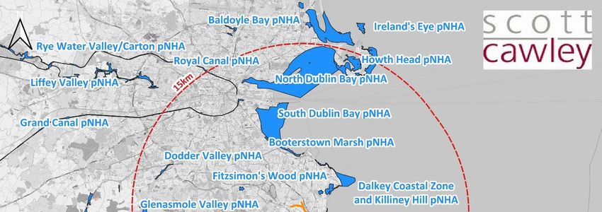
Cherrywood SDZ Green Routes Network

2.          Description of the Proposed Development
2.1         Introduction
The Applicant is proposing to construct a c.6.0km Greenway which provides a cycle and pedestrian greenway
network, for the area within the Cherrywood SDZ. The greenway network is based on the preliminary routing
indicated in the Cherrywood SDZ and will extend from Brides Glen Road in the south to Lehaunstown Road and
Brennanstown in the north. The proposed greenway will be 4.0m wide, designed in accordance with TII Publication
‘DN-GEO-03047-02 – Rural Cycleway Design (Offline). In the Druids Glen Woodland, an 800m long pedestrian
walking route is proposed, which will comprise resurfacing of existing pathways through the existing Druids Glen
Woodland.

The Proposed Development is located on a c. 9.45 hectares (ha) site (including greenway, paths and links,
earthworks and landscaping) in Cherrywood, Co. Dublin.

Figure 2-1 Route Sections along Scheme Route

Prepared for: Dun Laoghaire-Rathdown County Council                                                     AECOM
                                                                                                           2/63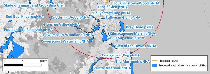
Cherrywood SDZ Green Routes Network

3.          EIA Screening Process
3.1         Introduction
This section outlines the legislative basis for “Screening” in order to decide whether the Proposed Development
requires the preparation of an Environmental Impact Assessment Report (EIAR).

3.1.1       EIA Directive
The European Communities (EC) EIA Directive 85/337/EC, codified by Directive 2014/52/EU, lists those projects
that require an EIAR (Annex I) and those projects for which an assessment must be undertaken to determine if
they are probable to result in likely significant effects (Annex II). For Annex II projects, individual Member States
can choose to institute specific thresholds or project specific considerations, or a combination of both of these
approaches to arrive at a decision regarding the requirement for an EIAR.

Annex II developments that do not exceed the thresholds for the mandatory requirement to prepare an EIAR are
categorised as sub-threshold and must be assessed on a case-by-case basis to determine whether or not they are
likely to have significant impacts on the existing environment. The likelihood of a significant environmental effect is
the principal matter around which consideration of the requirement for an EIAR is based. Annex III sets out the
criteria to be examined when carrying out EIA screening.

A significant environmental effect has the potential to occur as a result of the nature of the proposed development,
the scale, massing or magnitude of the proposed development and the intended location of the development in
relation to particular environments sensitive to the development.

In Ireland, generally the process of ascertaining whether a development requires an EIA is determined by the
Planning and Development Act 2000 (as amended) which takes into consideration the Planning and Development
Regulations 2001 (as amended). and the Roads Act 1993 (as amended).

3.2         Legislation

3.2.1       Environmental Impact Assessment (EIA)
The EIA Directive (Directive 85/337/EEC) requires an environmental assessment to be carried out prior to
development consent being granted for projects considered likely to have a significant effect on the environment.
The amended Directive 2014/52/EU improves the level of environmental protection for the environment and pays
greater attention to emerging threats and challenges such as resource efficiency, climate change and disaster
prevention.

The Planning and Development Act 2000 (as amended) has been amended by the EU (Environmental Impact
Assessment) (Amendment) Regulations 2019 to take account of the requirements of the EIA Directive 2014/52/EU.
Annex III of the EIA Directive is specifically referenced in Section 50(1)(e) of the Roads Act 1993, as amended, to
be considered when carrying out EIA screening.

3.2.2       Appropriate Assessment (AA)
Council Directive 92/43/EEC of 21 May 1992 on the conservation of natural habitats and of wild fauna and flora,
which is more commonly known as ‘the Habitats Directive’, requires Member States of the European Union (EU)
to take measures to maintain or restore, at favourable conservation status, natural habitats and wild species of
fauna and flora of Community interest. The provisions of the Habitats Directive require that Member States
designate Special Areas of Conservation for habitats listed on Annex I and for species listed on Annex II. Similarly,
Directive 2009/147/EC on the conservation of wild birds (more commonly known as ‘the Birds Directive’) provides
a framework for the conservation and management of wild birds. It also requires Member States to identify and

Prepared for: Dun Laoghaire-Rathdown County Council                                                           AECOM
                                                                                                                 3/63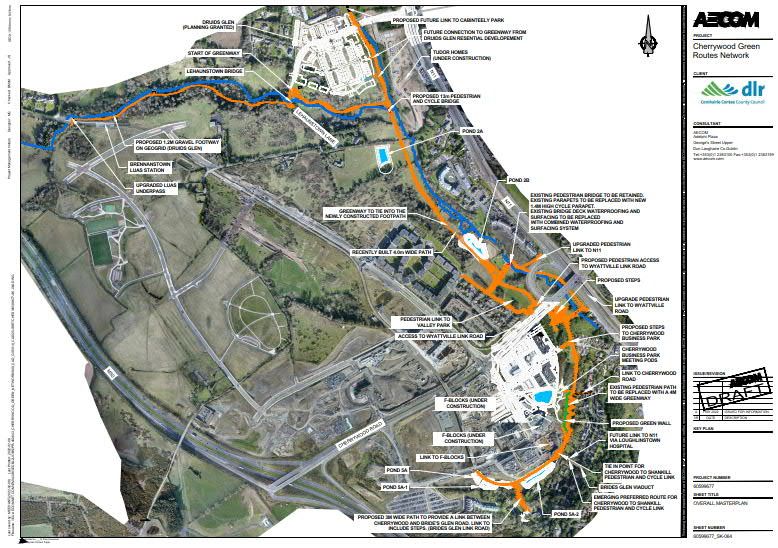
Cherrywood SDZ Green Routes Network
classify SPAs for rare or vulnerable species listed on Annex I of the Directive, as well as for all regularly occurring
migratory species. The complete network of European sites is referred to as ‘Natura 2000’.
Under article 6(3) of the Habitats Directive, any plan or project which is not directly connected with or necessary to
the management of a European site but would be likely to have a significant effect on such a site, either individually
or in combination with other plans or projects, must be subject to an ‘Appropriate Assessment’ (AA) of its
implications for the SAC / SPA and its nature conservation objectives.
In Ireland, the requirements of Article 6(3) are transposed into national law by Part 5 of the European Communities
(EC) (Birds and Natural Habitats Regulations) 2011 (S.I. No. 477 of 2011)) (more commonly referred to as the
‘Habitats Regulations’) and Part XAB of the Planning and Development Act 2000.
The Proposed Development was subject to an Appropriate Assessment (AA) Screening, which was conducted by
Scott Cawley (Scott Cawley, 2022a). This AA Screening determined:
“the potential impacts associated with the proposed route do not have the potential to affect the receiving
environment and, consequently, do not have the potential to affect the conservation objectives supporting
the qualifying interest / special conservation interests of any European sites. Therefore, the proposed
route is not likely to have significant effects on any European sites”.
It also concluded that there was no potential for any other plan or project to act in-combination with the Proposed
Development to result in significant effects on any European site.
Therefore, it was recommended that the application for consent for the Proposed Development does not require
an Appropriate Assessment (AA) and the preparation of a Natura Impact Statement (NIS).
3.3 Methodology
The screening was undertaken in line with Section 3.2 of the EPA’s ‘Guidelines on the Information to be contained
in Environmental Impact Assessment Report (DRAFT)’ (EPA, 2017). The assessment also takes into consideration:
the ‘Environmental Impact Assessment of National Road Schemes - A Practical Guide’ (TII 2008),
the Department of Housing Planning and Local Government’s (DHPLG) ‘Guidelines for Planning
Authorities and An Bord Pleanála on carrying out Environmental Impact Assessment’ (DHPLG, 2018); and
the Environment, Heritage and Local Government guidance document “Environmental Impact
Assessment (EIA) Guidance for Consent Authorities regarding Sub-threshold Development”.
Additionally, the screening process can be aided using the checklists contained in the EC Environmental Impact
Assessment of Projects: Guidance on Screening’ (EC, 2017), in particular the “Screening Checklist” and the
“Checklist of Criteria for Evaluating the Significance of Environmental Impacts”.
The screening checklist completed for the Proposed Development, is contained in Appendix A of this report.
Ascertaining whether this Proposed Development requires an EIA is determined by reference to mandatory and
discretionary provisions set out in the Planning and Development Act 2000 (as amended)).
A ‘road’ is a defined under the Roads Act 1993 (as amended) to include;
(a) any street, lane, footpath, square, court, alley or passage,
(b) any bridge, viaduct, underpass, subway, tunnel, overpass, overbridge, flyover, carriageway (whether
single or multiple), pavement or footway,
(c) any weighbridge or other facility for the weighing or inspection of vehicles, toll plaza or other facility
for the collection of tolls, service area, emergency telephone, first aid post, culvert, arch, gulley,
Prepared for: Dun Laoghaire-Rathdown County Council AECOM
4/63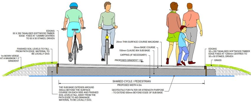
Cherrywood SDZ Green Routes Network

                         railing, fence, wall, barrier, guardrail, margin, kerb, lay-by, hard shoulder, island, pedestrian refuge,
                         median, central reserve, channelliser, roundabout, gantry, pole, ramp, bollard, pipe, wire, cable, sign,
                         signal or lighting forming part of the road, and

             (d)         any other structure or thing forming part of the road and

             (i)         necessary for the safety, convenience or amenity of road users or for the construction, maintenance,
                         operation or management of the road or for the protection of the environment, or

             (ii)        prescribed by the Minister.

Furthermore, a ‘Cycleway’ is referred to in Section 68 of the Roads Act 1993 (as amended) as follows:

1.      In this section “cycleway” means a public road or proposed public road reserved for the exclusive use of pedal
        cyclists or pedal cyclists and pedestrians.
        a.     A road authority may construct (or otherwise provide) and maintain a cycleway.
        b.     Where a road authority constructs or otherwise provides a cycleway it shall by order declare, either-
                    i.    the cycleway is for the exclusive use of pedal cyclists, or
                    ii. that the cycleway is for the exclusive use of pedal cyclists and pedestrians.
        c.     any person who uses a cycleway in contravention of an order under paragraph (b) shall be guilty of an
               offence.
In respect of the above definition under Section 68 of the Roads Act 1993, as amended. The Proposed
Development is considered to be a public road; therefore, this EIA screening will be assessed under Section 50 of
the Roads Act 1993 (as amended).

3.3.1          Assumptions
The EIA screening undertaken assumes the construction of the Proposed Development would comply with
regulatory, best practice and incorporate environmental controls, such as an approved Construction Environmental
Management Plan (CEMP). The CEMP would include best practice and regulatory pollution control measures such
as noise, vibration and dust controls, emergency response including an emergency spill response plan, Waste
Management Plan (WMP), procedures for dealing with unexpected archaeological discoveries, and health and
safety provisions. The CEMP would also include details of any environmental monitoring requirements;
communication protocols, and particular measures as set out within the environmental reports accompanying this
Part 8 Planning application such as the Ecology Impact Assessment (EcIA) and the Archaeological & Architectural
Assessment as well as any mitigation measures set out by the conditions associated with planning approval (if
granted). It is assumed all mitigation, compensatory measures and enhancement measures set out within the
accompanying environmental reports (e.g. the Ecology Impact Assessment and the Archaeological & Architectural
Assessment) would be implemented during the construction and operational phases of the Proposed Development.
A CEMP is therefore to be produced by the appointed Contractor prior to construction. This requirement will be
included within the contract for the Proposed Development.

Where waste materials would need to be taken off-site for segregation or disposal, it has been assumed the
contractor would ensure this is undertaken by a licensed haulier under chain of custody procedures to an
appropriately licensed waste facility as per the Waste Management Plan (WMP). The waste hierarchy should also
be considered as part of the WMP.

Prepared for: Dun Laoghaire-Rathdown County Council                                                                      AECOM
                                                                                                                            5/63
Cherrywood SDZ Green Routes Network
3.3.2 Legislative Grounds for an EIA
3.3.2.1 Planning and Development Regulation Screening
The Proposed Development does not fall under any of the developments requiring an EIA as listed under Schedule
5, Part 1 of the Planning and Development Regulations 2001 (as amended). The Proposed Development could be
considered to align with Schedule 5, Part 2, Infrastructure Projects, item 10 (b) (iv), of the Planning and
Development Regulations 2001 (as amended). The criteria is contained in Table 3-1 however while this has been
included for completeness, the Proposed Development is considered a road development under the Roads Act
1993 (as amended) (see Section 3.3). Where Part 2 10 (b) (iv) references a business district this is defined as a
district within a city or town in which the predominant land use is retail or commercial (Schedule 5, Part 2 of the
Planning and Development Regulations, 2001).
Table 3-1 Mandatory Environmental Impact Assessment Criteria Established under the Planning and
Development Regulations
Mandatory Regulatory Reference Mandatory Criteria Met?
Part 2 (10) (b) (iv) Urban development which would S.I. 600 of 2001 of the No - The overall Proposed
involve an area greater than 2 hectares in the case of a Planning and Development Development is 9.45 ha and
business district, 10 hectares in the case of other parts of falls below 10 hectares in the
1 Regulations 2001, as amended
a built-up area and 20 hectares elsewhere . case of other parts of a built-
up area. The Proposed
S.I. 93 of 1999 of European Development is not
Communities (EIA) considered to fall within a
Regulations, as amended business district.
The Proposed Development does not fall under any of the developments requiring an EIA as listed under Schedule
5, Part 1 of the Planning and Development Regulations 2001 (as amended) and does not meet the criteria of
Schedule 5, Part 2 of the Planning and Development Regulations 2001 (as amended). As such the Proposed
Development does not require a mandatory EIA under the Planning and Development Regulations 2001 (as
amended).
3.3.2.2 Section 50, Roads Act 1993 (as amended)
Table 3-2 outlines the mandatory criteria considered under legislation during this EIA screening assessment.
It has been assessed that the Proposed Development does not trigger the mandatory criteria for a road
development under Section 50 of the Roads Act 1993 (as amended).
Given the potential for significant environmental effects resulting from potential cultural heritage, water and
biodiversity impacts during the construction of the Proposed Development it was determined a sub threshold
assessment was required for the Proposed Development to identify if an EIA is required.
1
In this paragraph, “business district” means a district within a city or town in which the predominant land use is retail or
commercial use.
Prepared for: Dun Laoghaire-Rathdown County Council AECOM
6/63Cherrywood SDZ Green Routes Network
Table 3-2 Summary of the Mandatory Legislative Requirements for Environmental Impact Assessment (EIA)
Impact Screening under the Roads Act (as amended)
Mandatory
Mandatory Regulatory Reference Criteria
Met?
S. 50.- (1) (a)(i) of the Roads
Construction of a motorway No
Act, 1993 (as amended)
S. 50.- (1) (a)(ii) of the Roads
Construction of a busway No
Act, 1993 (as amended)
S. 50.- (1) (a)(iii) of the
Construction of a service area Roads Act 1993 (as No
amended)
The construction of a new road of four or more lanes, Article 8 of the Roads
or the realignment or widening of an existing road so Regulations, 1994 (Road
as to provide four or more lanes, where such new, development prescribed for
Any prescribed type of No
realigned or widened road would be eight kilometres or the purposes of S.
road development more in length in a rural area, or 500m or more in 50(1)(a)(iv) of the Roads Act
consisting of the length in an urban area. 1993 (as amended)
construction of a
proposed public road or Article 8 of the Roads
the improvement of an Regulations, 1994 (Road
existing public road. The construction of a new bridge or tunnel which would development prescribed for
No
be 100 metres or more in length. the purposes of S.
50(1)(a)(iv) of the Roads Act,
1993 (as amended)
Source: Roads Act 1993, as amended
3.3.3 Sub-Threshold Assessment
Where the Proposed Development does not meet, or exceed, the applicable threshold (Table 3-2), the likelihood
of the Proposed Development having significant effects on the environment needs to be considered. The
discretionary (or sub-threshold) requirements are based on an assessment of the likely significant environmental
effects of the Proposed Development.
The Roads Act 1993 (as amended), outlines circumstances under which an EIA for a sub-threshold road project
may be required; these are summarised in Table 3-3.
Table 3-3 Summary of the Sub-threshold Legislative Requirements for Environmental Impact Assessment
Screening
Sub-threshold Requirements Regulatory
Reference
If An Bord Pleanála (ABP) considers that any road development proposed (other than development to
which paragraph (a) applies) consisting of the construction of a proposed public road or the improvement
S. 50(1)(b) of the
of an existing public road would be likely to have significant effects on the environment it shall direct that
Roads Act, 1993
the development be subject to an environmental impact assessment.
(as amended)
Where a road authority or, as the case may be, the Authority considers that a road development that it
proposes (other than development to which paragraph (a) applies) consisting of the construction of a S. 50(1)(c) of the
proposed public road or the improvement of an existing public road would be likely to have significant Roads Act, 1993
effects on the environment, it shall inform An Bord Pleanála in writing prior to making any application to (as amended)
the Bord for an approval referred to in section 51(1) in respect of the development.
(i) a European Site within the meaning of Regulation 2 of
In particular, where a proposed development the European Communities (Birds and Natural Habitats)
(other than development to which paragraph
Regulations 2011 (S.I. No. 477 of 2011)
(a) applies) consisting of the construction of a
proposed public road or the improvement of S. 50(1)(d)(i-vi) of
(ii) land established or recognised as a nature reserve
an existing public road would be located on the Roads 1993 (as
within the meaning of section 15 or 16 of the Wildlife Act
— amended)
1976 (No. 39 of 1976)
(iii) land designated as a refuge for fauna or flora under
section 17 of the Wildlife Act 1976 (No. 39 of 1976)
Prepared for: Dun Laoghaire-Rathdown County Council AECOM
7/63Cherrywood SDZ Green Routes Network
Sub-threshold Requirements Regulatory
Reference
(iv) land designated a natural heritage area under
section 18 of the Wildlife (Amendment) Act 2000
(v) A Nature Reserve within the meaning of sections 15
or 16 of the Wildlife Act, 1976. (vi) Refuge for Fauna
(vi) Refuge for Fauna under section 17 of the Wildlife Act,
1976.
The road authority or the Authority, as the case may be, proposing the development shall decide whether or not the proposed
development would be likely to have significant effects on the environment.
Where a decision is being made pursuant to this subsection on whether a road development that is
S. 50(1)(e) of the
proposed would or would not be likely to have significant effects on the environment, An Bord Pleanála,
Roads Act, 1993
or the road authority or the Authority concerned (as the case may be), shall take into account the relevant
(as amended)
selection criteria specified in Annex III.
(i) make the decision available for inspection by
Where a road authority or the Authority, as members of the public, and S. 50(1)(f) of the
the case may be, makes a decision under Roads Act, 1993
paragraph (d) it shall — (ii) make an electronic version of the decision available (as amended)
on its website.
Source: Roads Act 1993, as amended
As per Section 50(1)(e) of the Roads Act 1993 (as amended) in considering whether a project is likely to have
significant environmental effects, given the potential for likely significant effects on the environment resulting from
potential cultural heritage, water and biodiversity impacts during the construction of the Proposed Development the
criteria set out in Annex III of the Directive 2014/52/EU, must be assessed. The criteria is as follows:
Characteristics of Proposed Development;
Location of Proposed Development; and
Type and Characteristics of Potential Impacts.
Consent authorities must have regard to these criteria in forming an opinion as to whether or not a sub-threshold
development is likely to have significant effects on the environment.
As per the EPA’s Draft Guidance, a significant effect can be defined as “An effect which, by its character, magnitude,
duration or intensity alters a sensitive aspect of the environment” (EPA, 2017).
3.4 Characteristics of the Proposed Development
3.4.1 Size and Design of the Proposed Development
The Proposed Development will be 4.0m wide and will be a shared use facility, used by pedestrians and cyclists.
The path will be segregated from traffic for the entirety of the route. It is proposed that the Proposed Development
will comprise of a thin course macadam surface. The proposed bound surface pavement construction will be made
up of the following and as is shown in Figure 3-1.
20mm thin surface course;
55mm base course;
150mm Clause 804 subbase (machine laid to achieve correct ride quality); and
Capping (where necessary).
Prepared for: Dun Laoghaire-Rathdown County Council AECOM
8/63Cherrywood SDZ Green Routes Network
Figure 3-1 Proposed Greenway Cross Section
Softwood timber kerbs are proposed for this greenway. It is proposed instead to extend the subbase to 300mm
beyond the surface course on each side, as is shown in Figure 3-1.
The Proposed Development also includes a pedestrian path (0.8km long 1.2m wide max), which will be constructed
through Druids Glen. It is proposed to retain the existing path width though the Druids Glen, c. 1.2m wide, but will
be narrowed if there will be an unacceptable impact on existing trees or ecology.
The overall length of the Proposed Development is c. 6.0km. The Proposed Development Site covers an area of
c. 9.45ha (including greenway, paths and links, earthworks and landscaping). One new bridge has been proposed,
crossing the Carrickmines River. The proposed bridge has been designed with a total span of 12.75m. The bridge
has been designed using steel, with concrete abutments.
3.4.2 Cumulation with other Existing and / or Proposed Developments
A desktop search of proposed and existing planning applications was undertaken on the 17 January 2022. The
search used publicly available data from MyPlan.ie ‘National Planning Application’ database, Dun Laoghaire-
Rathdown County Council (DLRCC) planning application portal and An Bord Pleanála’s (ABP) online database.
The purpose of the search is to assess the cumulation with other existing and / or proposed developments. The
scope of the search was based on a 2.0km radius taken from the approximate centre point of the Proposed
Development. The initial search flagged planning applications within a period dating back to 2011. A specified
criteria informed the search and omitted any refused, invalid and withdrawn applications. The criteria then focused
on foreseeable developments to be considered in line with the Proposed Development. In respect of this, any small
scale residential type developments, such as; extensions and modifications, minor amendments to existing
dwellings and changes of use were omitted from the search.
The relevant planning application search is listed Appendix B. The findings show small, medium and large-scale
developments within the 2.0km scope that have been approved. In addition, an extended search was undertaken
for Part 8 applications from the DLRCC online database. A number of the identified planning permissions relate to
the Cherrywood SDZ area including planning reference DZ18A/0854. This Proposed Development includes a
section of greenway as proposed under planning reference DZ18A/0854. This Proposed Development is not
functionally dependent on planning reference DZ18A/0854 as this Proposed Development has included the
greenway that is located within the red line boundary of planning reference DZ18A/0854.
In consideration of the Proposed Development being located within an SDZ of this magnitude, there will be
temporary and transient impacts from noise, traffic and dust associated with construction of the Proposed
Prepared for: Dun Laoghaire-Rathdown County Council AECOM
9/63Cherrywood SDZ Green Routes Network
Development in-combination with the surrounding developments. Should the development of a number of large
developments identified within the planning search occur at the same time there is potential for negative effects of
slight to moderate significance, however these would be temporary in duration, occurring during the construction
phase only. Planning approved developments within the Cherrywood SDZ will be phased.
There is likely to be a positive, long-term, slight to moderate cumulative impact from the Proposed Development
with other cycleway and pedestrian routes in the area.
3.4.3 Nature of any Associated Demolition Works
There will be no demolition works associated with the Proposed Development. However, upgrading and redesign
of some existing footpaths will occur which could result in the generation of wastes to be taken off-site.
3.4.4 Use of Natural Resources, in Particular Land, Soil, Water and Biodiversity
Some aggregates such as asphalt for the road / cycle surfacing; Clause 804 stone for the sub-base layer; concrete
for foundations and granite kerbs / flag stones will be imported to the Proposed Development Site and used during
the construction phase; however, exact quantities are unknown at this stage.
All imported materials will be sourced from licensed suppliers. It is assumed a water supply will be required during
the construction phase however it is unknow if water mains will be utilised or if the water required will be tankered
onto site.
Should the water mains be utilised, all relevant permissions should be sought prior to construction, such as written
agreement from Irish Water and relevant stakeholders. At no point will water be abstracted from rivers or streams.
3.4.5 Production of Waste
There will be waste produced during the construction phase of the Proposed Development. Whilst the exact amount
of this waste has not been evaluated, the Contractor will be required to prepare a Construction and Demolition
Waste Management Plan (CDWMP) and any waste produced as part of the development will be dealt with in
accordance with all relevant waste management legislation and guidance.
3.4.6 Pollution and Nuisances
Potential pollution pathways and nuisances for consideration include increases in exhaust emissions to air as a
result of construction machinery; noise and vibration from equipment use; social effects as a result of temporary
traffic diversions; leaks and spills of hydrocarbon containing materials used, and runoff of material to nearby
watercourses.
It is recommended that normal construction mitigation measures are implemented through the contractor’s CEMP,
which should include noise and vibration limits as per best management practices and mitigation measure for dust
during the construction phase. In addition, the contractor’s CEMP should also include an emergency response
procedure for any spills that may occur during the construction phase.
The likelihood and severity of these effects will be minimised through compliance with best practice construction
management practices as defined in the contractor’s CEMP.
While there have been no reports of potential contamination at the Proposed Development Site, it should be
considered when removing any material off-site.
Prepared for: Dun Laoghaire-Rathdown County Council AECOM
10/63Cherrywood SDZ Green Routes Network
3.4.7 Risk of Accidents and / or Disasters Which are Relevant to the Project Concerned, Including
Those Caused by Climate Change in Accordance with Scientific Knowledge
An accident, in the context of the Proposed Development, means an unplanned event caused by a man-made
activity or asset resulting in death, injury, or immediate or delayed serious damage to the environment. A disaster
in the context of the Proposed Development, is a naturally occurring phenomenon such as an extreme weather
event (e.g. storm, flood, extreme temperatures) or ground-related hazard events (e.g. subsidence, landslide,
earthquake) with the potential to cause an event or situation that leads to immediate or delayed serious damage
to human health, welfare and/or the environment and requires the use of resources beyond those of the developer
or its contractors to manage.
A major accident, in the context of the Proposed Development, means an uncontrolled event caused by a man-
made activity or asset that may result in immediate or delayed serious damage to human health, welfare and / or
the environment and requires the use of resources beyond those of the proposed developer or its contractors to
manage.
Important considerations are the potential risks of the Proposed Development causing an accident and / or disaster
during the construction and operational phases, and the vulnerability of the Proposed Development to potential
man-made and natural disasters.
The size of the Proposed Development is not of a sufficient size or scale for a major accident or disaster to occur
during the construction phase as normal construction mitigation measures (such as the contractors Health and
Safety plan, an approved contractor’s CEMP and approved methods of work) will be adhered to on the Proposed
Development Site. As mentioned in Section 3.4.6 above, the implementation of appropriate control measures
(including an emergency spill response plan) and best management practices will reduce the risk of accidents from
polluting substances entering soil and groundwater.
There may be minor emissions of greenhouse gases to the atmosphere from truck movements and the operation
of site construction equipment; however, a significant impact is not considered likely given the type and scale of
the development. During the operational phase, there will be no emissions to air as the Proposed Development is
non-vehicular.
The Loughlinstown watercourse to the North of the site was classed as an Area for Further Assessment (AFA)
during the CFRAM Programme.
The Flood Risk Management Plan (FRMP) for the Avoca - Vartry River Basin (Unit of Management 10) described
the Loughlinstown area as an Area for Further Assessment (AFA). The FRMP Flood Extents suggest the
Loughlinstown area is vulnerable and sensitive to climate change scenarios. The Flood Extents produced by the
CFRAM suggest that the Proposed Development extent is within Flood Zone A and Flood Zone B, (Figure 3-2).
The primary source of flood risk to the site is fluvial flooding.
Prepared for: Dun Laoghaire-Rathdown County Council AECOM
11/63Cherrywood SDZ Green Routes Network
Figure 3-2 CFRAM Flood Map
The OPW Flood maps for the area indicate a previous flood event (Dated Flood - 24/10/2011) in the southern
section of the Proposed Development Site2.
A Flood Risk Assessment (FRA) was carried out by AECOM for the Proposed Development (AECOM 2020a). The
report concluded:
“The Stage 1 – Flood Risk Identification identified that the site is likely to be impacted by fluvial flooding
with flooding identified in the CFRAM study, Dunlaoghaire County Council Strategic Flood Risk
Assessment (DLRCC SFRA) and County Development Plan and a planning application for a development
at ‘Beech Park’.
The Stage 2 – Initial Flood Assessment determined that the proposed project would be classified as
“water-compatible” development as it is “amenity/open space”. The construction of the scheme within
‘Flood Zone A’ is appropriate without the need for further justification.
A new bridge structure is proposed on the Carrickmines River just upstream of the confluence with the
Cabinteely Stream. A hydraulic modelling exercise has been subsequently undertaken to determine the
flood levels at this location and the impact of the new bridge structure to satisfy the requirements of OPW
as part of the Section 50 Application process. This modelling exercise found that the bridge would have
a very limited impact in a localised area in the vicinity of the structure.”
The required section 50 has been applied for and consented.
Based on the above, the risk of the of the Proposed Development being particularly vulnerable to, or which the
Proposed Development has a particular capacity to exacerbate accidents and/or disasters, is considered low.
2
OPW Flood Maps Accessed 11/09/2020
Prepared for: Dun Laoghaire-Rathdown County Council AECOM
12/63Cherrywood SDZ Green Routes Network
3.4.8 Utilities
AECOM have contacted utility providers in relation to the Proposed Development. The following utility providers
have utilities in the Proposed Development Site.
Eir – Lehaunstown Lane (adjacent to the Linear Park).
ESB Networks;
─ There are two underground ESB ducts in the Cherrywood Business Park, which run up to
Lehaunstown Valley (south).
─ There are ESB overhead cables crossing over Lehaunstown Valley (south) and Druids Glen.
Gas Network Ireland (GNI) – A 250 PE 4 bar, is found in Lehaunstown Valley (south), adjacent to the D-
loop.
Water Services DLRCC.
─ Two foul pipes are found in the Lehaunstown Valley (North and South).
─ A watermain is also found in the Lehaunstown Valley (South). Irish water will be contacted as part of
the detailed design procedures.
─ An Asbestos 20-inch watermain pipe is located in the Cherrywood Business Park. Consultation will be
undertaken with Irish Water and DLRCC Water Services regarding the location of the pipe. Slit
trenches will be undertaken to find an accurate level of this pipe prior to detailed design and
construction. The diversion of this pipe is not anticipated as part of the Proposed Development.
It has been assumed that affected utilities infrastructure will be protected in-situ, where possible.
If utility diversions and realignments are required during the construction phase, these should be carried out in
accordance with relevant guidance documents, such as Gas Networks Ireland’s publication ‘Safety advice for
working in the vicinity of natural gas pipelines’; the ESB’ Code of Practice for Avoiding Danger from Overhead
Electricity Lines’, 2008 and the HSA ‘Code of Practice for Avoiding Danger from Underground Services’, 2010.
Should service diversions be deemed necessary, it is assumed close liaison with the relevant service providers will
be carried out.
3.4.9 Risks to Human Health
With the implementation of appropriate mitigation measures during the construction phase (including an emergency
spill response plan and measures outlined within the Contractor CEMP), the risks to human health; for example,
due to water contamination or air pollution is considered low.
In addition to this, there will be no emissions to air during the operational phase as the Proposed Development is
non-vehicular; therefore, risks to human health, such as air pollution, during the operational phase is also
considered low.
Prepared for: Dun Laoghaire-Rathdown County Council AECOM
13/63Cherrywood SDZ Green Routes Network
3.5 Location of the Proposed Development
3.5.1 Existing and Approved Land-Use
In consideration of Section 166 under Part XI of the Planning and Development Regulations 2001 (as amended),
it states;
(1) Where, in the opinion of the Government, specified development is of economic or social importance
to the State, the Government may be order, when so proposed by the Minister, designate one or more
sites for the establishment, in accordance with the provisions of this Part, of a strategic development zone
to facilitate such development.
(2) The Minister shall, before proposing the designation of a site or sites to the Government under
subsection (1), consult with any relevant development agency or planning authority on the proposed
designation.
(b) specify the type or types of development that may be established in the strategic development
zone.
As the Proposed Development Site is situated within a Strategic Development Zone (SDZ), A Planning Scheme for
the SDZ has been approved by An Bord Pleanála. The SDZ consists of c. 360ha of land and is expected to provide
approximately 7,700 residential units in a new town centre and three new villages. The Planning Scheme has set
out the specified objectives in which the Proposed Development aims to achieve.
Seven primary land uses have been identified: Town Centre, Village Centre, High Intensity Employment,
Commercial uses, Residential, Education and Green Infrastructure. The Proposed Development focuses on the
proposed green infrastructure, which is set out in the Cherrywood SDZ as “A network and hierarchy of green
infrastructure will be incorporated throughout the area to form a legible, accessible and pleasant outdoor
environment.”
Figure 3-3 shows the proposed Green Infrastructure in the Cherrywood SDZ.
Prepared for: Dun Laoghaire-Rathdown County Council AECOM
14/63Cherrywood SDZ Green Routes Network
Figure 3-3 Map of Primary Land-Uses
In reference to the Proposed Development, the Green Infrastructure (GI) chapter within the Planning Scheme3, has
set out objectives, particularly;
GI 22 - To require the improvement and continuation of the Linear Park adjacent to Cherrywood Business
Park and proposed Town Centre to link with surrounding greenways and habitats, Bride’s Glen Road and
Bride’s Glen Luas Stop.
GI 37 - To promote greenways which reflect and contribute to the distinctive character and appearance of
their settings.
GI 53 - Encourage awareness among local communities of the existence of important greenways,
treelines and ecological connectivity to ensure their retention and management for future generations.
GI 71 - To promote a child-centred approach, based where appropriate on ‘home-zone’ principles, that
enables children to:
• Move freely and safely around their neighbourhood;
• Play within sight of their home;
• Play in the natural environment;
• Play at purposefully designed play facilities.
3
https://www.dlrcoco.ie/sites/default/files/atoms/files/2017_planning-scheme-chapter-5.pdf
Prepared for: Dun Laoghaire-Rathdown County Council AECOM
15/63Cherrywood SDZ Green Routes Network
GI 77 - To require the design, as an integral component of the Cherrywood Urban Form Development
Framework (see Figure 6.1) of a clear, legible and inviting network of civic open space, incorporating
pedestrian and cycle links, between Tully Park and Bride’s Glen. Civic open spaces shall be located at
pedestrian focal points e.g. adjacent to the Tully Park Greenway, Luas stops, Wyattville Road pedestrian
link. This provision shall be set out with regard to the qualitative and quantitative requirements of the
current County Development Plan.
The Cherrywood Planning Scheme identified a network of walking and cycling facilities in Cherrywood as shown
in Figure 3-4 (Map 2.5 of the Cherrywood Planning Scheme). Cherrywood has been designed with a hierarchy of
streets where the main vehicular traffic will be directed onto the major routes. The overall plan is based on 5- and
10-minute walking distances (400-800m) from public transport / district and neighbourhood centres, so it should be
safe to walk and cycle between all principal nodes within the SDZ lands.
Figure 3-4 Cherrywood SDZ Access and Movement (Map 2.5 of the Cherrywood Planning Scheme)
3.5.2 The Relative Abundance, Availability, Quality and Regenerative Capacity of Natural Resources
in the Area (Land / Soil / Water and Biodiversity)
As outlined in Section 3.4.4, construction materials, including stone, asphalt, concrete and granite will be imported
from outside the area during the construction phase. Other than this imported material, the use of natural resources
is not required to facilitate provision of the Proposed Development.
Should the water mains be utilised during construction, all relevant permissions should be sought prior to
construction, such as written agreement from Irish Water and relevant stakeholders. At no point will water be
abstracted from rivers or streams.
The Proposed Development is not anticipated to result in any significant environmental effects on the quality and
regenerative capacity of natural resources in the area (including land/soil/water and biodiversity).
Prepared for: Dun Laoghaire-Rathdown County Council AECOM
16/63You can also read