DESKTOP STUDY - Castle of Good Hope Integrated Conservation Management Plan 2020 - 2024 September 2018 - Castle Of Good ...
←
→
Page content transcription
If your browser does not render page correctly, please read the page content below
Castle of Good Hope

Integrated Conservation Management Plan
              2020 - 2024

            DESKTOP STUDY

             September 2018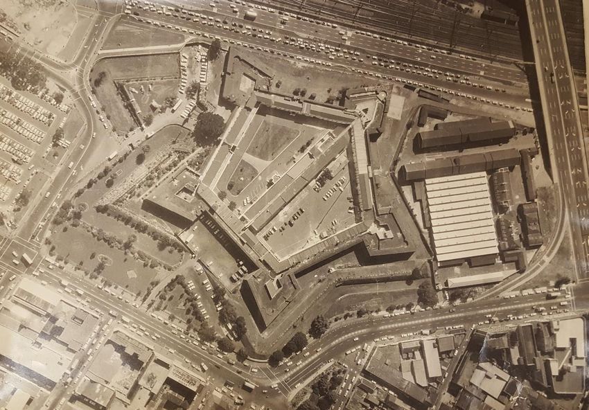
Vision

The Castle Control Board shall be a globally significant, truly accessible centre of excellence that
showcases South Africa’s shared heritage.

                                                 Mission

The Castle Control Board is a service-orientated public entity, striving to create an environment
where national pride serves to:

    •   Build an internationally known and recognised cultural and heritage brand for Ubuntu,
        dialogue, nation-building and human rights recognition;
    •   Guarantee the development of a smooth functioning, self-sustaining, “must-see” iconic
        visitor and learner destination;
    •   Optimises its tourism potential and accessibility to the public; and
    •   Preserve and protect its cultural and military heritage by elevating it to United Nations
        Educational, Scientific and Cultural Organisation (UNESCO) World Heritage status.

                                                           -   From the Annual Performance Plan 2018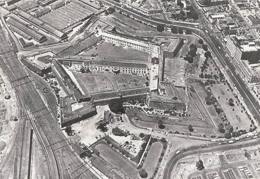
Table of Contents

List of Figures ......................................................................................................................................... iii
List of Maps ............................................................................................................................................ iv
List of Acronyms ...................................................................................................................................... v
1.         Introduction ................................................................................................................................ 1
     1.1       The Integrated Conservation Management Plan in context................................................... 1

     1.2       The Purpose of Desktop Study ................................................................................................ 2

2.         What is the Castle? ..................................................................................................................... 2
3.         The VOC Network........................................................................................................................ 4
       3.1.1          Influences on Fortification .............................................................................................. 5

       3.1.2          Dutch Systems of Fortification ........................................................................................ 6

       3.1.3          Fortifications and its placement within the landscape ................................................... 8

4.         Historical overview of the Castle of Good Hope ....................................................................... 14
5.         Spatial Themes .......................................................................................................................... 29
     5.1       Settlement at the Cape ......................................................................................................... 29

     5.2       Fortifications at the Cape ...................................................................................................... 29

     5.3       Cape Town Spatial Development .......................................................................................... 35

6.         Development of the Built Fabric of the Castle .......................................................................... 39
     6.1       Where are the sensitive archaeological areas of the Castle? ............................................... 53

7.         What is significant about the Castle? ....................................................................................... 56
     7.1       Tangible and Intangible Values ............................................................................................. 56

     7.2       Assessment of authenticity ................................................................................................... 57

       7.2.1          NHRA criteria that are applicable ................................................................................. 57

8.         Where the Castle fits within World Heritage ............................................................................ 58
     8.1       Identification of similar WHSs ............................................................................................... 58

9.         Conclusion ................................................................................................................................. 67
10.        Bibliography .............................................................................................................................. 69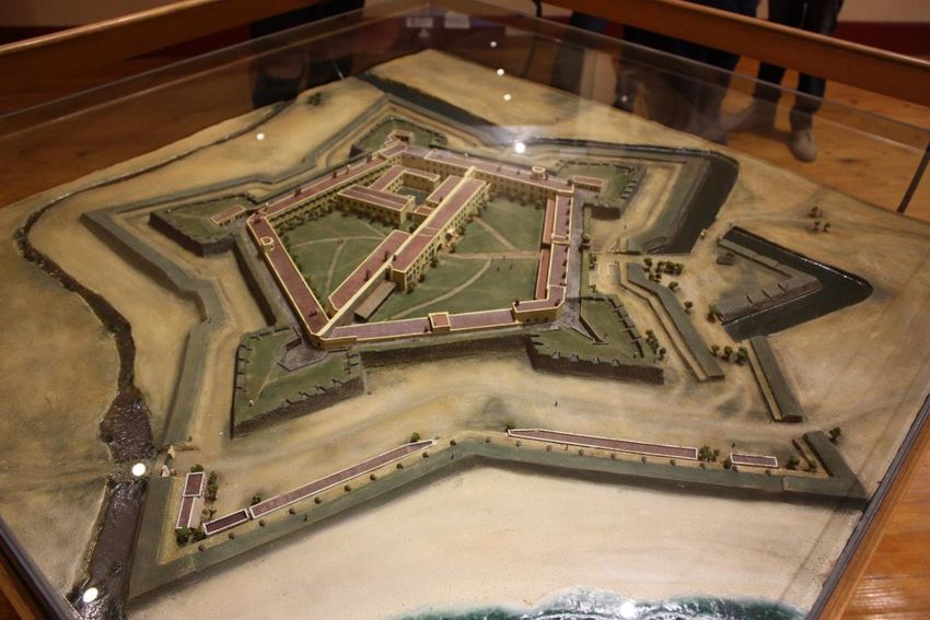
List of Figures
Figure 1: Ground Plan of the Entire fort by Simon Stevin and diagram from Vesting Gronichem ......... 6
Figure 2: Ground Plan of Fort Bourtang showing important terminology in the Old Dutch System of
fortification ............................................................................................................................................. 7
Figure 3: New Netherlands Fortification system at Coevorden 1790 -1795 and the development of
Bastions ................................................................................................................................................... 8
Figure 4: The Old Netherlands “Oudnederlandse stelsel” and the New Netherlands System
“Nieuwnederlandse stelsel” for fortification .......................................................................................... 8
Figure 5: Base Type of Dutch forts in Sri-Lanka and their distribution ................................................. 10
Figure 6: Extract from Lady Anne Barnards Panorama of the Cape (1) ................................................ 19
Figure 7: Extract from Lady Anne Barnards Panorama of the Cape (2) ............................................... 19
Figure 8: Extract from Lady Anne Barnards Panorama of the Cape (3) ................................................ 20
Figure 9: William Burchell's Vignette of the Castle Gates (1815) ......................................................... 21
Figure 10: Cetshwayo at the Castle c.a 1879 ........................................................................................ 22
Figure 11: Renovations to the "Ballroom", now the Fehr Collection Museum, 1937 .......................... 24
Figure 12: Demolition of Royal Engineers Buildings 1952 .................................................................... 25
Figure 13: A man walks past graffiti on the Castle walls between Buuren and Catzenellebogen ........ 26
Figure 14: Pickets from the ANC Observatory branch, Cape Town ...................................................... 27
Figure 15: President Vorster with the Springboks National Rugby Team inside the Castle in 1979 .... 28
Figure 16: Map of the Fort of Good Hope and the surrounding lands, between Table Bay and False
Bay......................................................................................................................................................... 36
Figure 17: Plan of the Fort of Good Hope, the Company’s Gardens and adjoining buildings and
stables ................................................................................................................................................... 37
Figure 18: Plan of the Company's Fort of Good Hope, gardens and buildings, as well as the confined
area for the beginning of a City for Free Citizens ................................................................................. 38
Figure 19: Progression of the Construction of the Castle of Good Hope ............................................. 40
Figure 20: Kasteel de Goede Hoop 1681 (1) ......................................................................................... 41
Figure 21: Kasteel de Goede Hoop 1681 (2) ......................................................................................... 41
Figure 22: Front Entrance gate to the Castle with the VOC emblems .................................................. 42
Figure 23: Model of the Castle showing Imhoff Battery before demolition and before Land
Reclamation of the Foreshore .............................................................................................................. 43
Figure 24: The Seaward Battery Lines c. 1847 ..................................................................................... 44
Figure 25: The Imhoff Battery c. 1850 .................................................................................................. 44

                                                                                                                                                            iii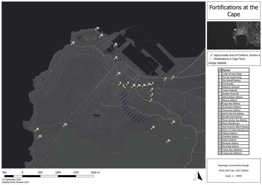
Figure 26: The Imhoff Battery c. 1860 .................................................................................................. 45
Figure 27: Castle and Railway Lines early 1900s................................................................................... 45
Figure 28: Castle c. 1950 showing the railway lines present ................................................................ 46
Figure 29: The Castle in 1967 with the railway lines removed ............................................................. 47
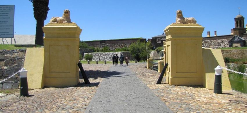
Figure 30: The Lions on the Outer Entrance Gateway Pillars, originally hollow clay, replaced with
replica cast ............................................................................................................................................ 49
Figure 31: Front Courtyard where Blocks B & F meet c 1920 ............................................................... 50
Figure 32: The Front Courtyard of the Castle following the restoration in 1993 ................................. 50
Figure 33: Rear Courtyard where Blocks B & C meet during restoration & excavation of Dolphin Pool
1983 ...................................................................................................................................................... 51
Figure 34: Rear Courtyard following restoration .................................................................................. 51
Figure 35: Rear Courtyard where Blocks C & D meet during restoration 1983 .................................... 52
Figure 36: The rear courtyard after restoration ................................................................................... 52
List of Tables
Table 1: Forts in the VOC Network ....................................................................................................... 11
Table 2: Defence Structures on the Cape Peninsula before 1850 ........................................................ 31
Table 3: National Heritage Resources Act Criteria................................................................................ 57
Table 4: Comparison of the Castle of Good Hope to similar World Heritage Sites .............................. 59
Table 5: Comparison of WHS Criteria ................................................................................................... 66
List of Maps
Map 1: The Castle of Good Hope ............................................................................................................ 3
Map 2: The VOC Trade Network during the Dutch Golden Age ............................................................. 5
Map 3: Map showing locations of Fortifications in and around Cape Town c. 1800 ........................... 30
Map 4: Archaeological Investigations at the Castle of Good Hope ...................................................... 54
iv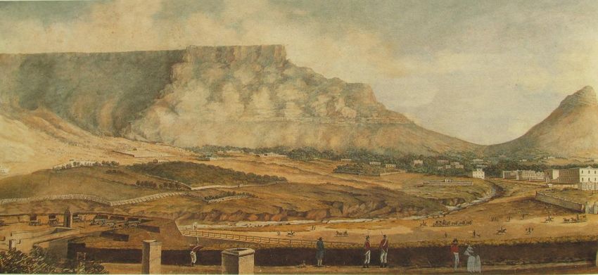
List of Acronyms

ANC      African National Congress
CCB      Castle Control Board
DEA      Department of Environmental Affairs
DKG      Donker Gat
DSM      Darling Street Moat
NHRA     National Heritage Resources Act
SADF     South African Defence Force
SAHRA    South African Heritage Resources Agency
OUV      Outstanding Universal Value
UNESCO   United Nations Educational, Scientific and Cultural Organization
VOC      Vereenigde Oostindische Compagnie

                                                                            v
1. Introduction

1.1 The Integrated Conservation Management Plan in context
The Castle of Good Hope is the oldest surviving colonial building in South Africa and has been
recognised as a site of heritage significance since the late 19th century when efforts to have it
demolished were rejected. In 1936, the Castle of Good Hope was the first site in South Africa to be
declared a National Monument, its significance being self-evident. In 1999, with the commencement
of the National Heritage Resources Act (No. 25 of 1999) (NHRA), the Castle of Good Hope was
included as a “former National Monument” and was essentially treated as a Provincial Heritage Site.
In October 2016, the South African Heritage Resources Agency (SAHRA) declared the Castle of Good
Hope a National Heritage Site), in terms of Section 27 (5) of NHRA. The statement of significance has
been recorded at the time of declaration as follows:

        STATEMENT OF SIGNIFICANCE:

        It is understood that the Castle of Good Hope is arguably the oldest fortress and building in
        South Africa. It is currently the oldest functioning Dutch colonial building of the period. It has
        retained its function as military site and centre of ceremonial military activity of the Cape
        Regiments. It currently houses the William Fehr Collection, the Military Museum and is home
        to the Cape Town Highlanders Regiment. The Castle of Good Hope represents an aesthetic
        particular to fortifications built by the Dutch.

                                                           (Government Gazette, 14 October 2016)

In all of these various states of being, the Castle of Good Hope has never had a directed exploration
of its significance.

In line with the Vision and Mission, the Castle Control Board (CCB) aims to preserve and protect its
cultural and military heritage by elevating it to United Nations Educational, Scientific and Cultural
Organisation (UNESCO) World Heritage status. The concept of World Heritage was developed by
UNESCO to determine cultural and natural heritage that is irreplaceable, unique and authentic, not
only for the nation to which they belong, but also for humanity as a whole. It is considered that the
degradation, erosion or loss of heritage of global significance, would be a loss of all the peoples of
the world. As such, a site of World Heritage status is based on its Outstanding Universal Value (OUV).

While intentions exist to pursue a Nomination Dossier for the Castle of Good Hope, a road map
towards World Heritage Site status starts with the development of its 1st Integrated Conservation
Management Plan (ICMP). The ICMP is essentially a guiding document for the management of the
Castle of Good Hope for the period 2020-2024. Such a Plan is required by UNESCO to sustain and
conserve the heritage it contains, and to safeguard its significance. Once inscribed as a World
Heritage Site, the ICMP should be updated every five years. Within that period there will be regular
monitoring and periodic State of Conservation Reports to be submitted to UNESCO by the State
Party namely, the Department of Environmental Affairs (DEA). These plans have to be updated
periodically to reflect changing realities and address challenges that may emerge as time passes.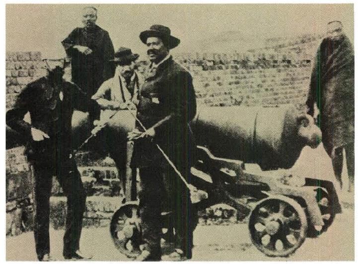
1.2 The Purpose of Desktop Study
The purpose of this Desktop Study is to provide a context of the Castle of Good Hope, and is the first
step towards the development of the Integrated Conservation Management Plan (ICMP). As such
the Desktop Study explores the historical context and overview, spatial themes, significance in line
with the NHRA and World Heritage criteria and where the Castle of Good Hope fits within World
Heritage. Moreover, the Desktop Study will form the basis for the Situational Analysis (or Status Quo
Report) that will describe all aspects pertaining to the management and operations of the site, and
ultimately feed into the ICMP.
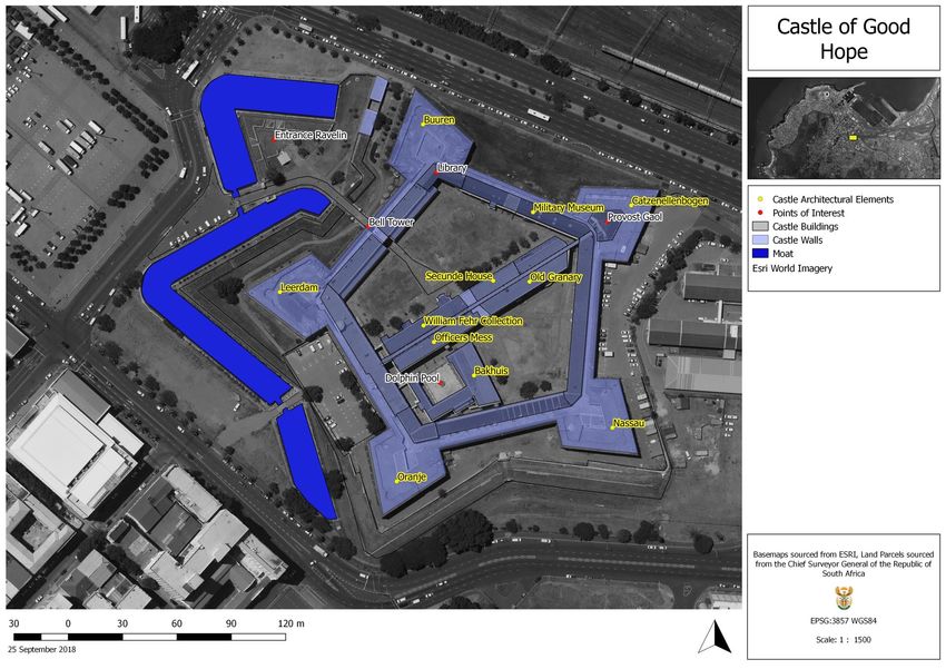
2. What is the Castle?
The Castle of Good Hope, also referred to as the ‘Castle’, is situated near Cape Town’s central
business district and is bounded by Strand Street, Darling Street, Castle Street and Sir Lowry Road. It
was built as a Dutch fortress on the beach of Table Bay to defend the newly established settlement.
Subsequently land was reclaimed in front of it for the building of the Imhoff Battery (1744–1896),
the railway lines and station (1859), and the harbour (1930’s).
It is South Africa’s oldest colonial building, and, apart from being a tourist attraction, it currently
houses offices for the military and other organisations, a military museum, part of the William Fehr
art collection and a restaurant.
The main defensive walls of the Castle were built in the shape of a pentagon with shear stone walls
facing outwards and buildings, accommodating various uses, facing into the remaining central
courtyard (bailey). The courtyard was then bisected by a building that created two courtyards, an
outer courtyard near the entrance, and an inner courtyard. A pointed stone bastion was built at the
five corners of the pentagon, each being named after the principal titles of the Dutch Prince.
2
Map 1: The Castle of Good Hope
3. The VOC Network
The Vereenigde Oostindische Compagnie (VOC) or ‘Dutch East India Company’ was a multinational
corporation that lasted from 1602 until 1795. The Company was originally established as a chartered
company to trade with India and Indianised Southeast Asian countries. It started out as a corporate
entity which acted like a state, an empire and even a world in its own right (Raben, 2013). The
‘Dutch Golden Age’ lasted from 1580 to about 1680 (Klingelhofer, 2010). In 1619, the Company
forcibly established a central position in the city of Jayakarta, Indonesia, changing its name to
Batavia (now Jakarta). In the following two centuries, it effectively established trade ports and
safeguarded their interest by taking over surrounding territory. By the turn of the century, the VOC
had established trade and outposts in west and southern Africa, Asia, and the Americas
(Klingelhofer, 2010).

In these foreign colonies, the VOC had the power to wage war, negotiate treatise, establish formal
colonies, imprison and execute convicts. Dutch commercial interests were not, however,
unchallenged. During the second half of the 17th century, competition for the West African trade was
fierce, to a large extent fuelled by the continued growth of the Atlantic slave trade. European
powers scrambled for African outposts. Competition was played out against a backdrop of shifting
alliances, wars, and political intrigue. Forts were frequently raided, occupied and reoccupied by
other European powers. By 1700, the Portuguese, Dutch, English, French and Brandenburgers
(Prussia) had established trade posts in West Africa with varying success.

The VOC’s more than 350 settlements varied from small trading posts to large-scale European style
fortifications, stretching between the two pivots of the Cape of Good Hope and Batavia, present day
Jakarta on the Island of Java (Klingelhofer, 2010). As a result of strong western competition during
the seventeenth century, VOC forts followed the development in complexity in Western Europe.
Map 2: The VOC Trade Network during the Dutch Golden Age 1

3.1.1 Influences on Fortification
The longevity and permanence of the VOC in its trade ports was largely dependent on the European-
style fortresses that turned out to be almost unconquerable. The VOC’s warehouse and
administration would always be located within the fortress with the rest of the city outside its walls
(Mostert, 2009). Trade posts were established based on the goods or service these could deliver,
and therefore the importance of the goods to be located within the fort itself, not to be disrupted by
any local power or European rivals. Forts against local power were often simpler structures, while
those against European powers needed to stand against more sophisticated weapons. The
fortifications built by the VOC were based on the specific military architecture in use at the Dutch
Republic at the time. In Medieval Europe, the period between 500 and 1500, defence works were
built by means of thick-walled castles and comparable town ramparts. A revolution in warfare
commenced with the introduction of firearms around 1450. Masonry walls could no longer
withstand cannon, and earthen ramparts were added to strengthen existing masonry defence works.
In the second half of the 16th century, the Italian art of fortification was introduced in the
Netherlands, and subsequently further improved by Dutch military theoreticians like Simon Stevin,
to become complicated geometric designs that did not leave any angle where the defending artillery
could not reach. It was this particular Oudnederlandse Stelsel, the Old Netherlands System, of
fortification that would be exported by the VOC (Klingelhofer, 2010). Forts became symbols of

1
 https://theartisticnautilus.wordpress.com/about/the-dutch-east-india-company-trade-in-the-dutch-golden-
age/

                                                                                                           5
power, as these could not only protect the city but could also control a sea-lane or serve as a base of
operations of a fleet (Mostert, 2009).
3.1.2 Dutch Systems of Fortification
In Europe, the Dutch were at the forefront of fortress design, a highly scientific and specialised
profession. The VOC, however, did not hire such specialists to its forts, instead it made use of local
city architects of the larger VOC settlements such as Batavia or Colombo. They made these fortress
designs based on the methods and handbooks that were developed by Simon Stevin and his
contemporaries who developed standardised plans for fortresses and only needed to be adapted to
the local environment (Mostert, 2009). In 1594, Stevin published De Sterctenbouwing (The Building
of Fortifications) in which he gave guidelines on the construction of Fortresses. In this paper Stevin
also gave much attention to the use of water as a defensive system (Cataloque Exhibition University
Library Leiden, 2004:6) (Weebers et. al., 2013). The codified fort developed by Simon Stevin was
characterised by its bastioned arrangement and referred to as the Old Netherlands Fortification
System “Oudnederlandse stelsel”. The system is characterised by bastions situated at right angles to
the curtain wall, and by the use of a small breastwork “Fausse Braye” at the foot of the wall, and the
inner edge of the moat to protect the main defence work (Fitchett, 1996). Figure 1 shows the use
thought behind the use of bastions to avoid dead angles. The distance between two bastions was
prescribed as the maximum effective range of a musket. An ideal fort was supposed to have a four
or preferably five-sided ground plan. Construction of a fort started with the outlining of the desired
ground plan, using stakes and measurement chains. Subsequently, the moat was dug and the
excavated soil used to erect the curtain wall, a high wall with an exterior slope of 65 degrees. The
rampart was lined with sods and brushwood. At the rear, a rampart walk was constructed for the
defenders. Standing on the rampart walk the soldiers could lay their musket on the slightly
downwards-sloping parapet of the main rampart and fire. At the field side of the moat was a
covered way, protected by the glacis, an embankment sloping toward the open country, giving a
clear field of fire to the defenders.
Figure 1: Ground Plan of the Entire fort by Simon Stevin and diagram from Vesting Gronichem 2
2
https://adcs.home.xs4all.nl/stevin/index-en.html and
https://vestinggorinchem.wordpress.com/vesting/beschrijving-vestingwerken/
6Figure 2: Ground Plan of Fort Bourtang showing important terminology in the Old Dutch System of fortification 3
The “Nieuwnederlandse stelsel” by Van Coehoorn was adapted to the level terrain of The
Netherlands and the most notable characteristic was that none of the defences should be visible on
approach. Van Coehoorn and his contemporary Vauban designed fortresses of various sizes and
designs and placing them at strategic locations. Vauban advocated a system to be adapted to local
conditions (Seeman, 1993). The new Netherlands fortification system made use of larger Bastions as
seen in Figure 2 that are no longer placed at a right angle to the curtain wall. The use of Ravelins are
and the “Fausse-Braye” is now omitted. The New Netherlands System is exemplified in the city walls
at Coevorden in Figure 3 of Schullers plan dating from the 1790’s. Very little of Coehoorn’s work
remain today, but by the time of his death in 1704 the new system replaced the old system (Fitchett,
1996).
3
Klingelhofer 2010.
7Figure 3: New Netherlands Fortification system at Coevorden 1790 -17954 and the development of Bastions5
Figure 4: The Old Netherlands “Oudnederlandse stelsel” and the New Netherlands System “Nieuwnederlandse
stelsel” for fortification6
3.1.3 Fortifications and its placement within the landscape
As a general rule, the complexity of the fortification mirrored the complexity of its use, while the
dimensions, the nature, and landscape of a site to be fortified defined the design of a fortification
(Klingelhofer, 2010). The locations of the fortifications were chosen on the basis of geographic,
military and political factors. With the introduction of Dutch military architecture in African and
Asian territories, it was met with a few problems. Geographic conditions proved to be a restriction to
the realisation of the prescribed ideal fort layouts. Fortifications built in the Old-Netherlands style
required a considerable area and, most importantly, a flat site, to fit in the outworks and glacis.
Suitable locations in mountainous VOC territories were hard to find. As a response, the VOC became
a master of pragmatism especially for the construction of outposts. Outposts were built to keep an
4
Fitchett, 1996.
5
Klingelhofer, 2010.
6
Fitchett, 1996.
8eye on production, to serve as temporary warehouses, and to hold back attacks. The most common
type of fort was the four-sided fort with four bastions. This type can be subdivided on the basis of
three varieties of bastions: four bastions, two diagonally opposite bastions and half bastions. Fewer
bastions or reducing their size meant less earth to be moved. A fortress was usually sited in close
proximity to fresh water. Adjustments to the Dutch systems can be found on Mauritius, where the
VOC faced only international challengers, but the diversity in fortification design is most clearly
recognisable on Sri Lanka (former Ceylon), where the VOC had both local and international
opposition. As a result, Ceylon presented a showcase from the elaborate to the humble, with every
location adjusted to its function in the VOC system of protecting trade and interests. Ceylon grew to
be one of the main possessions of the company, whereas Mauritius dwindled in its existence from a
possible alternate for the Cape colony to a constant sorrow and loss to the Company (Klingelhofer,
2010).
Comparison of forts in the VOC network
Forts in the VOC network could be classified into two categories, namely main forts or secondary
forts each relevant for its specific function.
Main forts included:
a. Forts as major administrative, military and economic centres;
b. Forts at strategic locations to safeguard the monopoly on trade goods; and
c. Forts as centres for storage of trade goods.
Secondary forts, mainly outposts, were mostly used as additional defence to forts placed in a
vulnerable position and were often structures that had the capacity to store goods.
Types of Forts
A classification system based on the base shape and number of bastions has been used to describe
the various types of forts found within the VOC network. Figure 5 shows the various types first found
just within Sri-Lanka. These forts were either designed for local or international warfare, and their
location on the coast or the interior had an impact on their design. Coastal forts typically needed to
face European conquerors, and therefore needed better structures to withstand the attack of more
sophisticated weapons, often in the form of naval vessels.
9Figure 5: Base Type of Dutch forts in Sri-Lanka and their distribution7
7
Jayasena, R. and Floore, P. 2010. Dutch Forts of Seventeenth Century Ceylon and Mauritius: An Historical
Archaeological Perspective. First Forts. Volume 60. Series: History of Warfare. pp. 235 – 260.
10The below table describes various significant fortresses within the VOC network. Some have been
destroyed over the years or have been reused for purposes other than their intended military use.
Table 1: Forts in the VOC Network
Fort Name and Design and Function Status
Location
Castle of Batavia, Main Fort: (replaced old fort): Destroyed
Jakarta Administrative, Military, Economic
Base: Type 4 for European warfare
Location: Coastal
1638 Fort Frederik Base: Type 2, rebuilt later to Type 4 Destroyed by hurricane in 1638
Hendrik, Mauritius (17th century) Burned down 1707
Style: Part timber Burned again by abandonment of
company in 1710
1665 Fort Frederick, Main Fort: Safeguard Monopoly on 1672 forced out by the French
Sri-Lanka trade Structure is overgrown and in
Base: seems like a Type 9 for dilapidated state
European warfare
Style: Dutch overtaken from
Portuguese
Location: Coastal, still in position
1609 Fort Nassau, Main Fort until Fort Belgica was built Main structure is visible but not in
Banda, Indonesia in 1673: Administrative, Military, use and dilapidated
Economic. First fort built and not
conquered (VOC warfare)
Base: Type 4 for European warfare
Style: Old Dutch on Old Portuguese
foundations, interesting bastions.
Location: Coastal
1673 Fort Belgica, Main Fort: Administrative, Military Restored in 1991
Indonesia and Economic
Base: Type 7 for European warfare
(renovated to this form in 1673. It
was a modest square)
Style: Old Dutch with imported stone
Location: Coastal, Overlooking fort
Nassau
Colombo, Main Fort: Administrative, Military, Destroyed
Sri-Lanka Economic
Base: Type 8 for European warfare
11Fort Name and Design and Function Status
Location
Style: Taken from the Portuguese,
partly rebuild to Old Dutch System
Location: Coastal
Jaffna, Sri Lanka, Main Fort: Administrative, Military, Although the structure of the
(Expanded after Economic pentagon is visible it seems that
1658) Base: Type 5 Only Local warfare the structure is in a dilapidated
Style: Captured from Portuguese and state
expanded in Old Dutch System Part of it is currently used by the
Location: Coastal, still in position Garrison
1663 Galle, Main Fort: Administrative, Military, Listed as a UNESCO site. An entire
Sri-Lanka Economic old town is still functioning within
Base: Seems like a Type 8 for the fortified walls. Damaged by
European warfare Tsunami in 2004
Style: Old Dutch system with Fausse
Braye and main rampart but
difference in material used. Captured
from Portuguese, but fortified by the
Dutch. The entire town is enclosed
by 14 bastions.
Location: Coastal, still in position
1628 Batticaloa, Main Fort: Safeguard Monopoly on The fort is still in reasonable
Sri-Lanka trade condition and currently houses
Base: Type 11 for European warfare several local administrative
Style: Captured from the Portuguese, departments government in new
additions made by the Dutch buildings, which are located within
the old structure. Still in original
position on the seafront
1672 Negombo, Main Fort: Storage on trade goods Ruins
Sri-Lanka Location: Interior
1640 Matara, Main Fort: Storage on trade goods Parts of the wall are visible on
Sri-Lanka Base: Seems like a Type 9 Google Earth
Style: Captured from Portuguese,
rebuild by Dutch in 1640
Location: Coastal
1765 Star Redoubt, Secondary Fort: Defence structure Good condition, now museum
Matara build but never tested in battle
Base: Type 3
12Fort Name and Design and Function Status
Location
Style: Dutch
Location: Coastal, Protecting the
main fort
1680 Katuwana Fort Secondary Fort: Fieldwork to Matara Visible on google earth,
Base: Type 5 for European warfare overgrown, not in use.
Style: Old Dutch System, bastions as
right angles to curtain wall
Location: Interior
Semarang, Java, Main fort: Storage on trade goods Destroyed, but Semarang is
Indonesia Base: Type 7 considered to be the best
Style: Old Dutch Style bastions preserved colonial settlement
Location: Coastal
1720 Fort Main Fort: Storage on trade goods Abandoned and Stripped in 1729
Lydsaamheid, Base: Type 11 for European warfare
Maputo, Style: Reconstructed Portuguese fort
Mozambique ruins
Location: Interior
1642 Elmina, Main fort: Storage on trade goods UNESCO World Heritage site
West Africa Base: Type 10
Style: Taken by Portuguese by VOC
Location: Coastal
Cape of Good Hope, Main Fort: Safeguard Monopoly on
South Africa trade
Base: Type 7 for European warfare.
Style: Old Dutch System, but local
rocks used for ramparts
Location: Coastal
This list of samples of fortified structures was explored to see how the Castle of Good Hope
compares to other VOC structures and whether some of them are still intact. From this short list, the
Castle of Good Hope is one of only a few structures with a Type 7 pentagonal base according to
Klingelhofer’s classification (2010); the only other two in this list are Fort Jaffna and Belgica in
Indonesia, that are both in dilapidated condition. None of the samples show the internal division for
additional defence that the Castle has.
From historic maps, the Castle of Batavia lines up in terms of its grid and layout to the layout of the
Castle of Good Hope, but unfortunately the Castle of Batavia does not exist anymore. Some of the
13other coastal forts show better integrity, with their placement on the sea still intact, whereas the
context of the Castle of Good Hope has been eroded with the infill of the coastline.
4. Historical overview of the Castle of Good Hope
Summary of the history of the Castle of Good Hope and the Cape
The Castle of Good Hope is the second fortress built by the Dutch East India Company on the shores
of Table Bay. The Castle has served as a focal point of colonial expansion in Southern Africa and has
played an integral role in the increasingly globalised network of colonial traders and merchants from
its creation to the present day. The history of the Castle cannot be isolated from the history of the
broader processes of colonial expansion, the development of Cape Town and the creation of two
European empires (Dutch and British).
With the landing of Jan Van Riebeeck in 1652, work on the construction of Fort de Goede Hoop (the
Fort – first fortress) was started immediately. The Fort was completed within a year but was already
deemed unsatisfactory in its intended purpose of defending the settlement from attacks by land or
sea due to the need for constant upkeep. The Fort was built along the lines of the Old Dutch
Fortification system initially pioneered in the Renaissance. The torrential rains of the Cape dissolved
the largely clay breastworks thereby requiring constant upkeep. These factors coupled with the need
for improved fortifications at the Cape, due to the outbreak of the Anglo-Dutch War (1664-1667),
resulted in the decision to construct a new fortress at the Cape.
A location for the Castle was chosen to the East of the settlement. The New Castle was to be built in
accordance with the pentagonal designs of Sebastiaan van Noijen, initially introduced in Dutch
Fortifications in the 1550s (Fitchett, 1996). The initial site clearing and foundation construction was
initiated in 1665, with the construction of the first Bastion (Leerdam) beginning the following year
(1666) (Fitchett, 1996). By the end of 1671, Leerdam was complete as well as the two curtain walls
on either side of the Bastion. The completion of the Catzenellenbogen (1672), Oranje (1673), Nassau
(1673) and Buren (1674) Bastions followed. The Castle was completed in 1679, however, the
Leerdam Bastion collapsed almost immediately, requiring the bastion to be rebuilt. In 1680, the
Commander of the Cape, Simon van der Stel, moved into the completed commanders’ quarters.
The completed curtain walls and bastions of the Castle were complemented with the construction of
buildings within the fortifications, including barracks, workshops, slave quarters, governor’s
residence, stables, and a church. At the centre of the Castle a well was dug to provide water in case
of a siege. Between 1682 and 1684, the entrance to the Castle was shifted from the ocean facing
curtain wall between Buren and Catzenellebogen, to the North West facing curtain wall between
Leerdam and Buren (Fitchett, 1996). The cross wall that bisects the old bailey of the Castle was built
following recommendations from the VOC commissioner in 1685, to lessen the area that could be
fired on within the Castle. Buildings were soon built on either side of the new cross wall, including
the new commanders residence, and the offices of the Secunde, or “second” to the Commander
(Johnson Barker & Museum, 2003).
The Castle was protected by a moat, which was fed from a stream from the Table Valley. In 1703, on
the recommendations of Commissioner Harman de Wilde, and with the approval of the Heeren17,
14the moat was deepened and extended to surround the Castle. The main entrance was also further
fortified.
The 1700s saw major expansion of the fortifications at the Cape, with the construction of the
Chavonne’s battery between 1715 and 1726, the construction of Fort Knokke in 1743, the
completion of the French lines and the commencement of the construction of the Imhoff Battery in
1744, and the construction of the Amsterdam Battery in 1784 (See Map 3 )(Johnson Barker &
Museum, 2003).
A detailed history of the development of the Castle of Good Hope is covered in Section 5 below.
Initial Expansion of the Colony
The initial settlement at the Cape was quickly found to be inadequate for the purposes of
replenishing supplies for passing ships. The solution was to create a farming class who could be
taxed and traded with for the VOC to better provide provisions to the passing ships. The initial farms
were granted in 1657, however the arrival of Simon Van der Stel in 1679 resulted in larger areas
being opened up to colonial settlement, particularly in the Stellenbosch District (Guelke, 1984). The
needs of the Company were rapacious. The requirements of fresh water and vegetables could largely
be covered by the new farming class, however the carrying capacity of the pasturage around the
various farms was inadequate. The result was that the Company resolved to procure most of their
meat supplies through trade with the Khoekhoen pastoralists on the edges of the now expanding
colony. This arrangement inevitably led to conflict with many cases of stock theft on both sides.
Usually, these incidents were addressed through military action by the Company.
The result almost always went the way of the settlers, with the Khoekhoen being pushed further and
further out of their traditional lands. The principle cause for conflict was usually disagreements
between the settlers and the Khoekhoen over the stock trade. These disagreements were made
worse by the general view that the VOC took of the Khoekhoen, one of a fractious, loosely cohesive
group of herders who under the leadership of various headmen, were indistinguishable from each
other. While one leader would be favoured at a time, such as Dorha (Klaas) of the Chainouqua,
others would be painted as villains, such as Gonnema of the Cochoquas (Theal, 1909). Following an
attack on a hunting party and later the Oudepost outpost in Saldanha Bay, the VOC started a series
of punishing raids on parts of the local Khoekhoen population, eventually driving Gonnema into the
mountains for a time (Theal, 1909). As a result, a tenuous peace was reached, with some groups of
Khoekhoen becoming allied with the colony.
The governance of Simon van der Stel resulted in prosperous expansion of the Colony (to the
detriment of the Khoekhoen). With his eventual retirement in 1699, his son, Willem Adriaan van der
Stel was promoted to the governorship. The Cape colony as it emerged out of the 1600s into the
1700s was expanding. The simmering conflict between the colony and the Khoekhoen over access to
land and ownership of stock flared up again in the early 1700s. The reprisal raids of the colony were
often comprised of both soldiers and farmers, however there were several instances of farmers
taking matters into their own hands and raiding on their own terms. The result was for the governor
Willem Adrian Van der Stel, to only allow reprisal raids to be undertaken by soldiers, rather than a
mixed militia of soldiers and farmers (Theal, 1909).
15The free burghers at the Cape were both dependent on and limited by the VOC monopoly on certain
trade goods. This led to increased tension between the Burghers and the Colony administration at
the Cape. The disagreement came to a head when a grievance, alleging abuse of the Company’s
Monopoly at the Cape by the Capes Senior Officials, was lodged with the VOC administrators in
Batavia. This grievance was ignored. Eventually a separate petition was secretly sent directly to
Holland. One of the authors of this separate petition, Adam Tas, was imprisoned in the “Donker Gat”
in the Castle from March 1706 until May the following year. The Governor began a process of
persecuting and purging anyone that he saw as challenging his authority. The eventual arrival of the
yearly merchant packet from Holland came with directives from the VOC for the recall of the
governor and the restitution of the civic rights to the Free Burghers.
VOC governance at the Cape
The Castle played a pivotal role as the seat of government in the Cape Colony. The Cape colony was
governed remotely by the VOC from their headquarters in Batavia (now Jakarta, Indonesia) until
1735 when it was given its own semi-independence (Mentzel, 1785). The Colony was originally
established under a commander, later increased to a Governor during the tenure of Simon van der
Stel in 1691.
A Council of Policy administered the Colony. It constituted the Governor, the Secunde (Vice
Governor), the fiscal (chief legal official), the commander of the Castle, and four senior merchant
officials from the VOC, including the director of the bureau, the Dispensir, the Warehouse -master
and shop-keeper. Once a week, the Council would meet in the council chambers of the government
house within the Castle. All petitions and governance tasks were controlled and administered by the
council. The Council had several sub councils, such as the Council of Justice that handled judicial
proceedings, the matrimonial chamber that recorded and formalised marriages, and the Orphan
Chamber (Mentzel, 1785).
Life in the Castle in the 1700s
Life in the Castle between 1700 and 1795 was largely limited to military and governance issues. The
government of the Colony was housed in the Castle, as well as the military command and a jail.
Contemporary accounts of the daily life in the Castle are limited, with Mentzel’s descriptions of his
experiences between 1733 and 1741 being one of the most detailed descriptions. However even his
descriptions lack detail in certain areas.
One of the primary functions of the garrison at the Cape was to keep time. The hour would be
sounded by ringing a bell by hand. Two “rondegangers” monitored an hour-glass and manually
recorded the hours as they passed. The Bell was installed in the bell tower in 1697 (Johnson Barker &
Museum, 2003).
Each day would start with an inspection of the Castle by a small patrol and the Castle entrance
would be unlocked. The work day would begin at 6am for labourers and slaves, with the soldiers
assembling for a parade at 7am. An elaborate switching of the guard would follow at 8am. The
Council, whether political or judicial, would convene at 9am and continue with their work till 11am
when everyone would take a break for the midday meal. At 1pm, the slaves and labourers would
return to work; however, the company officials would only return to work at 2pm. Officials would
16end work at 4pm, with labourers and slaves following at 6pm. The garrison drummers would then
sound the appel until 7pm. This would call all the soldiers back to the Castle, where a roll call would
take place. Following the roll call, evening prayers would be held in the Governors Hall. The Castle
Gate would be closed with the pedestrian Wicket Gate remaining open until 10pm when the Castle
gate would be locked. The sergeant of the guard would perform an inspection at 11pm. Then, on the
turn of every hour until 4am, the on-duty guards would perform a circular inspection of the Castle
(Mentzel, 1784).
Slaves at the Cape
From 1658 to 1795, slavery was practiced at the Cape under the VOC and continued until the
eventual emancipation of the slaves in 1834, under the British administration. A small number of
slave servants were present at the Colony from 1658 when the initial group of slaves were brought
to the Cape from the area of modern day Guinea (R. Ross, 1983). The population of slaves at the
Cape numbered around 838 at the beginning of the 1700s.
A small pox outbreak in 1713 decimated the Colony populace, but its effect on the Khoekhoen
populace was far greater. Large sections of the Khoekhoen Population were wiped out. The various
farmers who had in some instances relied on employing seasonal local labour, usually consisting of
the local Khoekhoen were not able to harvest their produce.
By 1717, the free-burgher class numbered around 400 settlers, with the Colony covering around half
a million hectares in the South-Western Cape (Guelke, 1984). The year 1717 was important, as a
decision was taken to lessen the importation of labour from Europe and instead to focus on using
slave labour. Skilled labour at the Cape was hard to come by with the Colony having to take
advantage of immigration wherever they could. The arrival of the French Huguenots and recruitment
of Europeans through the Orphan chamber in Europe resulted in some levels of increased
immigration, however this was not enough for the increasing demand for labour at the Cape.
While slaves had been at the Cape from the late 1600s, these had been mostly limited to male slaves
from South East Asia. After 1717, slaves were imported to the Cape in increasing quantities. Many of
the slaves were initially brought from Eastern India and Sri Lanka, however this shifted to South East
Asia, and eventually incorporated many slaves from the Mozambique and Madagascar Slaving
Operations. The total slave population was recorded at 14 747 in 1793, 29 861 in 1806 and 36 169 in
1834 (Worden, 2017).
Slaves were initially kept at Fort de Goede Hoop and contributed to some of the construction of the
Castle. However, following the Castle’s completion, slaves were mostly limited to domestic servants
within the Castle itself. Most slaves outside the Castle were used as labourers for the farming sectors
of the Colony. The Cape experience is different from that of the North American experience, as
most farmers owned less than 10 slaves, while only the most wealthy farmers had more than 20
(Worden, 2017).
The largest group of slaves was owned by the VOC and were kept at the Company Slave Lodge at the
foot of the Company’s Gardens. This building also housed lunatics and the overflow of the
neighbouring hospital (Worden, Van Heyningen & Bickford-Smith, 1998). From the development of
the Slave Lodge in 1680 (Fransen & Cook, 1980).
17The British take the Cape
The French revolution in 1789 disrupted many aspects of Western European society and
revolutionary armies fought several campaigns across Europe. In 1795, the Prince of Orange Willem
V fled Holland. As the British Empire was allied with the Dutch, a British fleet was dispatched to Cape
Town, to prevent the Colony from falling into French hands. The Fleet arrived on the night of 11 June
1795 in False Bay. The colonial forces were required to abandon the fortifications in Simons Town,
and made a stand at Muizenburg, making use of the terrain to concentrate the British forces
(Johnson Barker & Museum, 2003).
The British forces were able to advance past the Muizenburg position, as they were supported by
ships in the bay. The Colony fought a delaying action, deploying a hastily constituted Khoi Regiment.
The British advanced to modern day Mowbray before the colony was forced to surrender to the
advancing soldiers. The surrender was signed at Rustenburg on the 16th of September 1795 (Johnson
Barker & Museum, 2003). The British invasion was meant to be temporary, however the Cape
remained under British control until 1803 with the signing of the treaty of Amiens. The Castle was
never brought under direct fire, and was occupied by the British garrison following the surrender
(Worden et al., 1998).
The British did not find a warm welcome at the Cape. There was great animosity between the
Burgher Senate (the top six burgher citizens) and the new British administration. Many toasts were
given to the founder, Jan van Riebeeck, and a proposal was made to name Cape Town
“Riebeeckstad”, however the British continued the use of “Cape Town”(Worden et al., 1998).
General Craig, leader of the British ground forces in the Battle of Muizenberg, was installed as acting
governor until a proper British Governor could be sent to the Cape. Craig was relieved by the Earl of
McCartney as Governor in 1797 (Theal, 1908). McCartney chose to live in the Government house in
the Company’s Garden (Tuynhuis) (Anne Lindsay Barnard & Wilkins, 1901). Lady Anne Barnard and
her husband, Andrew Barnard arrived with the Governor and occupied the Governor’s residence in
the Castle.
Lady Anne Barnard at the Castle
A prolific letter writer, Lady Anne Barnard described many aspects of the Castle of Good Hope, as
well as various elements of Cape Town Society. She noted that the soldiers of the garrison were not
interested in the society orientated events of the Cape, as she herself was. Instead they were
concerned with drinking and gaming. The Barnard’s Quarters in the Castle were to her “a palace,
containing such a suite of apartments as makes me fancy myself a princess” (Barnard & Wilkins,
1901 Page 59). She redecorated the Governors quarters, styling the interiors of the buildings as an
English house with additional furniture. She proposed developing a party scene to encourage the
local Dutch women and military ensigns to socialise together (Anne Lindsay Barnard & Wilkins,
1901).
Lady Anne Barnard was a skilfully deployed politician. Historically, the society at the Cape was
heavily influenced by the Dutch, with most of the Burghers considering themselves Dutch citizens.
There was a degree of cultural difference, and a general feeling of distrust between the citizens of
the Cape and their new British administration. Lady McCartney did not accompany her husband and
18so it fell to Lady Barnard to shoulder many of the responsibilities, as one of the highest-ranking
members of the British Government at the Cape. She was important in enmeshing and enculturating
the Cape Dutch Society with the governing British elite.
Lady Anne’s descriptions of the Castle include the dolphin pool, the Governor’s residence, including
the size and shape of the rooms, as well as the various balls and events she hosted. Her descriptions
were useful, and the images and paintings that she created of the views from the Castle show an
interesting portrait of the Castle during this time.
Eventually, Lady Anne left the Cape in 1803 when the Colony was ceded back to the Dutch following
the signing of the treaty of Amiens. Her Panorama, drawn from the centre of the Castle shows in
detail the state of the fortifications at the time of the first British occupation.
Figure 6: Extract from Lady Anne Barnards Panorama of the Cape (1)8
Figure 7: Extract from Lady Anne Barnards Panorama of the Cape (2) 9
8
Barnard & Barker, 2009.
9
Ibid.
19Figure 8: Extract from Lady Anne Barnards Panorama of the Cape (3)10
The British permanently annex the Cape
The period in which the Cape was returned to the Batavian Republic was short lived as a British fleet
again arrived in Table Bay in January 1806. The British landed in Melkbosstrand and fought a battle
against the colonial forces behind Blouberg Hill. The Colony defenders were beaten back, with the
colony commander, General Janssen retreating towards Stellenbosch, intending to regroup and
launch a counter attack, however the British marched on to Cape Town. Cape Town was declared an
open city, and a treaty of capitulation was signed at the site of present day Treaty Road in
Woodstock. Throughout this time, the Castle did not fire a shot, nor was it fired upon (Johnson
Barker & Museum, 2003).
Unlike the previous time the Cape was annexed by the British, during the second conquest there was
an intention to permanently establish the Cape as a British colony. A re-assessment of the
fortifications at the Cape was begun soon after the colonial capitulation. New fortifications were
developed in Wynberg, as well as various upgrades around the Cape. Additions to the Castle
included the addition of a layer of brick work on top of the battlements. When William Burchell
visited the Cape in 1815, he drew a vignette of the Castle gates, clearly indicating the Castle
battlements without the brick layer (Burchell, 1822). The bricks were only added in the 1830s
(Johnson Barker & Museum, 2003).
10
Barnard & Barker, 2009.
20Figure 9: William Burchell's Vignette of the Castle Gates (1815)11
For much of the 1700s and into the 1800s, the Castle had been the seat of governance and military
command. Already during the first British annexation of the Cape, the Governor had moved out of
the Castle, preferring the Government house in the Gardens (Tuynhuis). The Second British period at
the Cape further disrupted the traditional seat of Power, with the government offices moving out of
the Castle and into the former VOC slave lodge at the foot of the Company’s Garden (1811). The
former Slave lodge became the High Court, with the military command remaining at the Castle of
Good Hope (Johnson Barker & Museum, 2003). As a result, the Castle became almost entirely a
military structure. Weekly military shows were held on the grand Parade, attended by the elite of
Cape Town. However, the social aspect of the Castle was gone and the new British administration
leased many of the military structures for private use, and demolished many others, including the
French lines. The Castle continued as a military structure and the main headquarters of the military
in the Cape Colony.
19th Century Military Action
Throughout the early and mid-19th century, the Colony was engaged in numerous border skirmishes
with the AmaXhosa on the Eastern Frontier of the Colony. The expansion of the colonial settlers into
the Eastern cape was increasingly leading to conflict over good grazing areas in the Zuurveld. The
conflicts had originally flared up during the last decades of VOC rule at the Cape, (1779, 1789 and
1799), however with the new British administration, conflicts became more protracted and of
greater impact to the colonial interests in South Africa. With border conflicts in the 18th century
mostly being handled by a combined force of Burgher Militia and VOC military forces, the new
British administration could not rely on this model to be effective in the long run. Because of
growing anti-British sentiment, and with areas of the Colony often in open revolt, the British colonial
government had to increase its own military involvement on the Eastern Frontier.
While the border wars of the 19th century happened at a considerable distance from the Castle,
many of the reinforcements sent to the Eastern Frontier were managed and housed for a time in the
Castle. Nine border wars were fought in total, between the colonial forces and the Xhosa, with the
latter eventually being defeated, due to in part the military action and the killing or imprisonment of
11
Burchell, 1822.
21their leaders on Robben Island, and the killing of their Cattle by the Xhosa themselves in hopes of
the Prophesies of Nongqawuse coming true (Peires, 1989).
Anglo-Zulu War
The Xhosa Chiefs imprisoned on Robben Island, Makhanda (Nxele), Siyolo, Maqoma and XhoXHo
were not the only African leaders brought to the Cape in Exile (H. Deacon, 1996). Following the
Battle of Islandwana in January 1879, the British fought a campaign to remove the Zulu King
Cetshwayo, who was defeated at the battle of Ulundi in July of 1879, and sent to Cape Town to live
in the Castle (Meredith, 2007). He was given quarters in the part of the Castle that now houses the
Military Museum. He was allowed to walk a section of the battlements, mostly around the
Catzenellebogen Bastion.
Figure 10: Cetshwayo at the Castle c.a 187912
Anglo-Boer War
While most of the military action in the Anglo-Boer War was concentrated in the northern sections
of South Africa, many of the regiments headquartered at the Castle were involved in the conflict.
The Cape Highlanders, the Cape Mounted Rifles and various artillery battalions were all
headquartered in the Castle. Many of the regiments were founded in the late 19th century and have
seen action in the Anglo-Zulu War, the Anglo Boer War, and the first and second world wars. With
12
Bisset, Kroukamp, & Le Roux, 1985.
22You can also read