Internet Presentation of Real Estate Market Data in North Rhine-Westphalia (NRW), Germany
←
→
Page content transcription
If your browser does not render page correctly, please read the page content below
Holger Wanzke, Internet Presentation of Real Estate Market Data in North Rhine-Westphalia Fachbeitrag
Internet Presentation of Real Estate Market Data in
North Rhine-Westphalia (NRW), Germany*
Holger Wanzke
Summary covers a town or district, and its members are volunteers
The committees of experts on real estate value in NRW pro- who are highly familiar with the real estate market. These
vide standard ground values and general pricing information are local real estate experts, such as architects, building
for developed real estate throughout the country, which is surveyors, estate agents, experts from banks and sworn
freely accessible via the Internet portal BORISplus.NRW. The experts.
information is derived from purchase contracts completed in Each committee of experts is supported by an office,
NRW every year, which are registered and evaluated by the which is usually located at the land surveying and ca‑
committees. dastral office or the town planning office. The offices
The Internet portal »www.borisplus.nrw.de« is based on the receive copies of all real estate contracts that are com‑
German spatial data infrastructure and uses international pleted within the respective town, and the relevant infor‑
OGC standards such as WMS and WFS, which means the mation is fed into a purchase price database. This results
standard ground values can also be used for the geoportals of in a large amount of data, which can be used to deliver
private operators. mathematic-statistical evaluations for the analysis of the
The initial version, BORIS.NRW, was launched in 2003 and local real estate market. On this basis, the committees of
was replaced in October 2008 by the redesigned version experts have the following tasks:
BORISplus.NRW. 17000 registered users and more than one n provide information on market value based on the pur‑
million hits per month are a sign of high acceptance, not least chase price database,
thanks to a service that is mostly free of charge. n derive data to assess the current real estate market,
n produce an annual publication of data in the form of
Zusammenfassung a standard ground value map and a real estate market
Die Gutachterausschüsse für Grundstückswerte in NRW stellen report,
in dem Internetportal BORISplus.NRW für jedermann flächen‑ n prepare valuation reports on fair market value and rent
deckend Bodenrichtwerte und eine allgemeine Preisauskunft value.
für bebaute Grundstücke bereit. Basis sind die in NRW jährlich
abgeschlossenen Kaufverträge, die von den Gutachteraus‑ The responsibility for organisation and task distribution
schüssen registriert und ausgewertet werden. lies with the 16 federal states, each using their own or‑
Das Internetportal »www.borisplus.nrw.de« basiert auf der ganisational model. North Rhine-Westphalia currently
deutschen Geodateninfrastruktur und nutzt internationale has 79 committees of experts, based at the offices of city
OGC‑Standards wie WMS und WFS. Dadurch können die Bo‑ and district councils.
denrichtwerte auch in den Geoportalen von privaten Betrei‑
bern genutzt werden.
Die erste Version als BORIS.NRW startete schon 2003, 2 Building a Spatial Data Infrastructure in
BORISplus.NRW ging mit neuem Design im Oktober 2008 ins Germany
Internet. 17000 registrierte Nutzer und über eine Million Sei‑
tenaufrufe pro Monat zeigen die große Akzeptanz, die auch In 2003, the German Federal Government decided to build
auf einem weitgehend kostenfreien Angebot basiert. a national spatial data infrastructure. This is controlled
by a steering committee in which the different levels of
government are represented.
1 Committees of Experts on Real Estate Values The spatial data infrastructure in Germany (SDI‑DE)
in Germany is a joint project of the federal, state and local govern‑
ments. The aim of the SDI‑DE is to establish a nation‑
The committees of experts on real estate values in Ger‑ wide and cross-departmental network of spatial data in
many were first introduced by law in 1960. Their aim was Germany to ensure that geoinformation will become a
and still is to provide transparency in the real estate mar‑ more important factor in decision-making processes in
ket in order to prevent excessive and erroneous trends. administrative, economic and political sectors. Apart
The special set‑up of the committees of experts has
proved very successful throughout its history of almost * Lecture held at the International Workshop on Spatial In‑
50 years. formation for Sustainable Management of Urban Areas, FIG
The responsibility for the committee of experts gener‑ Commission 3, Workshop 2009, Mainz, Germany, 2–4 February
ally lies with the federal state. Each committee of experts 2009.
134. Jg. 3/2009 zfv 163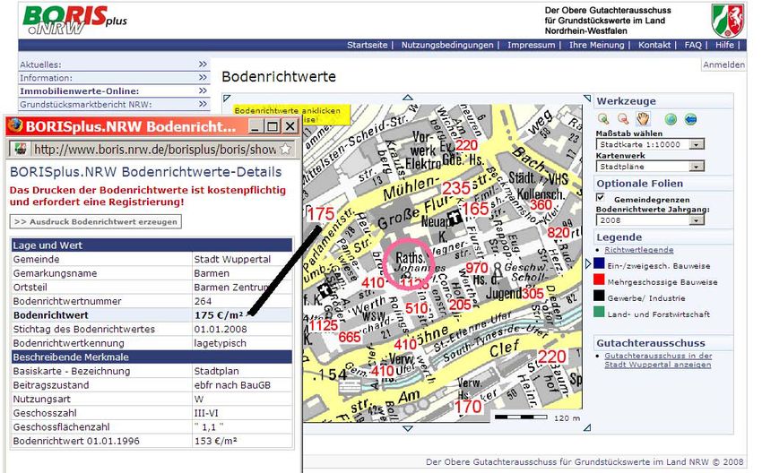
Fachbeitrag             Holger Wanzke, Internet Presentation of Real Estate Market Data in North Rhine-Westphalia

from the monitoring of national trends, the SDI‑DE will         n   It is also possible to purchase an »official« printout of
also observe developments at a European (INSPIRE) and               the relevant section of the standard ground value map
global (GSDI) level.                                                including explanations on letter-headed paper.
                                                                n   The real estate market report is available online as a
The SDI‑DE steering committee has the following tasks               PDF document – either as a general version (market
(www.gdi‑de.org):                                                   transparency for everyone), which can be downloaded
n develop a concept for an open SDI in Germany that                 free of charge or as a full version (required valuation
  will form part of a future European spatial data infra‑           data for experts), subject to charge.
  structure (GDI‑DE 2007),                                      n   Access to items available on BORIS.NRW that are sub‑
n control and coordinate the measures taken by state,               ject to charge requires an one-off registration with the
  local and federal governments in terms of the develop‑            Centre for Geoinformation of the federal state of NRW
  ment, continuation and implementation of standards                and the allocation of user identification by email. Once
  in European and international spatial data infrastruc‑            these steps have been completed, the user can access
  tures,                                                            the relevant data using his/her password and will
n define model projects for the implementation of net‑              be charged according to the cost of the information
  worked spatial data portals in Germany; based on the              downloaded.
  principle »some develop it and everybody can use it«,         n   A standardised dataset of the standard ground values
n ensure the compulsory provision of the national geo‑              (BoRi.xls) is available nationwide. This is published by
  database (NGDB) by the public authorities at federal,             the committees of experts on an annual basis.
  state and local level.                                        n   The dataset BoRi.xls is an independent product which
                                                                    can be purchased and used by third parties, subject to
                                                                    a licence agreement.
3 The »BORIS.NRW« project                                       n   In terms of the marketing of the BoRi.xls dataset, the
                                                                    Internet is only used for advertising and sales are pro‑
With the arrival of the Internet at the end of the 90s, the         cessed via the usual channels.
committees of experts faced the challenge of using this
new medium for the provision of real estate data. For this      Since its launch, BORIS.NRW has become the most suc‑
purpose, a project group was formed in NRW in 1998.             cessful e‑government project of the federal state of NRW.
A link portal was set up to collate the addresses and           17000 users have registered to purchase services through
services of the 79 committees of experts on real estate         the website and more than one million hits are recorded
value in NRW. Some of these also provided their standard        every month.
ground value maps as scanned tiles via the Internet.               BORIS.NRW contains standard ground values, i. e.
   The major breakthrough came with the creation of the         market information on undeveloped real estate. It does
standard ground value information system BORIS.NRW              not provide any information on real estate that has al‑
in 2003 (»BOdenRIchtwertinformationsSystem NRW«).               ready been developed.
                                                                   However, this has now changed with the introduction
BORIS.NRW includes the following essential elements             of the enhanced version BORISplus.NRW in 2008, which
(Dietrich et al. 2004):                                         informs users about price levels of single-family resi‑
n One common Internet portal to access all standard             dences and condominiums in NRW.
   ground values in NRW. It allows an address search
   by municipality, street name and house number or a
   geographical search by a series of scales of different       4 The Enhanced Version »BORISplus.NRW«
   official maps.
n For each selected address the user receives a map sec‑        Five years after BORIS.NRW was launched, it was time for
   tion containing details of the relevant standard ground      the Internet presence to be redesigned for three reasons:
   values.                                                      1.	As the demand for real estate market data of condo‑
n The explanatory characteristics of the standard ground            miniums and single-family residences increased, stan‑
   value can be activated by additional functions (left             dard ground values alone were no longer sufficient.
   mouse button, pop‑up window).                                2.	The technical concept of BORIS.NRW was conceived
n The user has the option of selecting one of the follow‑           between 2001 and 2002 – at a time when spatial data
   ing map backgrounds:                                             infrastructures were only developed conceptually, and
   – German Base Map 1: 5000,                                       standards such as those of the OGC had not yet been
   – Digital Topographic Map 1: 10000,                              sufficiently defined and established. For this reason,
   – Topographic Map 1: 50000,                                      BORIS.NRW was based on a proprietary design; maps,
   – Local Map 1: 10000/20000.                                      data and services were encapsulated within the pro‑
n The standard ground values plus characteristics can be            gramme.
   accessed free of charge.

   164   zfv   3/2009 134. Jg.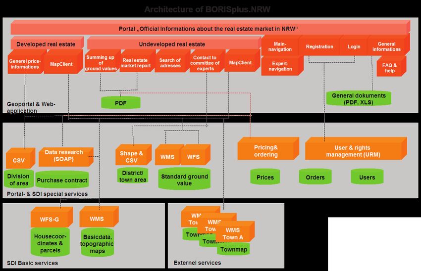
Holger Wanzke, Internet Presentation of Real Estate Market Data in North Rhine-Westphalia Fachbeitrag
Fig. 1: Architecture of
BORISplus.NRW (published
with friendly permission
[Karusseit 2008])
3. From 2004 on, federal and state governments agreed to n Data layer (green): This layer contains spatial data,
develop model projects for implementing the national map data and thematic data supporting the service
spatial data infrastructure. One of these model projects layer.
(in addition to the project »protected areas«) was the
creation of a national information system for standard
ground values. The project was successfully launched 4.1 Information on Standard Ground Values of
in NRW and was to be expanded to the remaining Undeveloped Real Estate
federal states. The project, called »networked standard
ground value information system« (VBORIS), defined Standard ground values are determined on an annual
the integration of standard ground value information basis by the committee of experts. The values are based
into a spatial data infrastructure (Liebig 2008). on a statistical analysis of completed purchase contracts
for undeveloped real estate. The contracts are categorised
These new concepts were implemented in BORISplus. in terms of the characteristics that determine their value
NRW. Based on an open spatial data infrastructure, it uses (size, usability, …) and are then assigned a standard value
standardised architectures such as WMS, WFS, and WCS (Schmeck 2007).
etc. The data model of the standard ground values con‑ Information available on BORISplus.NRW can be ac‑
forms to the national standard. The background maps for cessed by entering an address (house number) or a ca‑
the presentation of standard values and purchase prices dastre (parcel). The map section contains details about
are available from spatial data servers on the Internet. the standard ground values of the surrounding areas.
The thematic data of the standard ground values can be A mouse click on the value opens another window which
made available to other users for application in their real shows the relevant characteristics. The standard ground
estate portals, subject to the relevant licence agreement. value of the real estate can be determined with a cer‑
tain amount expertise by analysing the standard ground
The chart shows the architecture and different layers of values of the surrounding areas.
BORISplus.NRW:
n Application layer (red): This layer includes the web
applications which provide access to the entire system 4.2 General Pricing Information on Developed Real
via the geoportal. Estate
n Service layer (orange): This layer includes the portal
services, thematic services and basic services (also ex‑ The general pricing information is based on a specific da‑
ternal) on which the application layer is based. tabase search. The committees of experts receive all pur‑
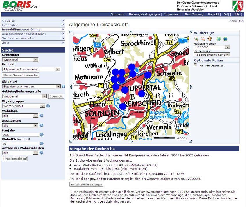
134. Jg. 3/2009 zfv 165Fachbeitrag Holger Wanzke, Internet Presentation of Real Estate Market Data in North Rhine-Westphalia
The screenshot shows the result of the
database search as a mean value, plus
sample size and standard deviation. For
reasons of data protection, the loca‑
tions of sample cases are anonymised
for the purpose of this search.
The search, including the on-screen
information, is free of charge; a PDF
printout may be purchased. For billing
purposes, the user is requested to com‑
plete an one-off registration process.
Monthly bills are issued by the Centre
for Geoinformation NRW.
This pricing information cannot re‑
place a qualified valuation according to
legal requirements, as it does not take
into account all value-specific factors
Fig. 2: Screenshot of standard ground value information (www.borisplus.nrw.de) and no site surveys are carried out.
5 Looking ahead
With the reform of the German Inheri‑
tance Tax Law, which took effect on
1 January 2009, the committees of ex‑
perts face new tasks when it comes to
valuating real estate.
With the Internet portal BORISplus.
NRW we have created a platform that
can provide even more data prepared by
the committees via online access. Our
goal for the next few years is therefore
to use this platform to provide more
specific data required for valuation by
real estate experts in a simple and cost-
effective way.
References
Karusseit, Oliver: BORISplus.NRW – Informations‑
portal für Boden- und Immobilienwerte. In: LDVZ –
Nachrichten 2/2008, Zeitschrift des Landesamtes für
Datenverarbeitung und Statistik des Landes NRW,
ISSN 1616-377X, S. 32–37.
Fig. 3: Screenshot of general pricing information (www.borisplus.nrw.de) Lenkungsgremium GDI-DE: Architekturkonzept
GDI-DE, Version 1.0, 2007. Internetpublikation:
chase contracts completed within their areas – for NRW www.gdi-de.org/
Liebig, Siegmar: GDI – Projekt VBORIS. In: FuB – Flächenmanagement und
the number of contracts amounts to approx. 150000 a Bodenordnung, ISSN 1616-0991, Jg. 70, Nr. 5, 2008, S. 212–216.
year. A database search allows the selection of specific Schmeck, Joachim: Die Entwicklung eines ImmobilienRichtwertInformati‑
onsSystems für Wohnimmobilien in Nordrhein-Westfalen. In: Nachrich‑
purchase contracts, which most closely match the selec‑ ten aus dem Öffentlichen Vermessungswesen Nordrhein-Westfalen, NÖV
tion criteria. 1/2007, ISSN 1863-4176, S. 28–46.
Wanzke, Holger: Das BOdenRichtwertInformationsSystem des Oberen Gut‑
achterausschusses und der Gutachterausschüsse für Grundstückswerte in
Possible criteria may include: NRW. In: Nachrichten aus dem Öffentlichen Vermessungswesen Nord‑
n address (town, part of town), rhein-Westfalen, NÖV 1/2007, ISSN 1863-4176, S. 18–27.
n type of property (condominium, terraced house, …),
Author’s address
n location, Holger Wanzke
n year of construction, Chairman of the Committee of Experts on Real Estate Value in the
City of Wuppertal
n fittings and fixtures,
Johannes-Rau-Platz 1, 42269 Wuppertal, Germany
n size. holger.wanzke@stadt.wuppertal.de
166 zfv 3/2009 134. Jg.You can also read


