Investor Presentation - GOLD CORP. CNSX: GTCH OTCQB: GGLDF - Getchell Gold Corp.
←
→
Page content transcription
If your browser does not render page correctly, please read the page content below
GOLD CORP.
Investor
Presentation
February 2021

CNSX: GTCH
OTCQB: GGLDF

                page 1
Forward Looking Statements
  Certain of the statements made and information contained herein are “forward-looking information”. These statements relate to future events or the Company's
  future performance. Statements, other than statements of historical fact, may be forward-looking statements. Generally, these forward-looking statements can
  be identified by the use of forward-looking terminology such as “anticipates”, “plans”, “budget”, “scheduled”, “continue”, “estimates”, “forecasts”, “expect”, “is
  expected”, “project”, “propose”, “potential”, “targeting”, “intends”, “believes” or variations of such words and phrases or statements that certain actions, events
  or results “may”, “could”, “would”, “might”, or “will be taken”, “occur” or “be achieved” or the negative connotation thereof. These statements involve known and
  unknown risks, uncertainties and other factors that may cause actual results or events to differ materially from those anticipated in such forward-looking
  statements. The Company believes that the expectations reflected in those forward-looking statements are reasonable, but no assurance can be given that
  these expectations will prove to be correct and such forward-looking statements included in this presentation should not be unduly relied upon by readers, as
  actual results may vary. In particular, this presentation contains forward-looking statements, pertaining to the following: capital expenditure programs,
  development plans, treatment under governmental and taxation regimes, expectations regarding the Company's ability to raise capital, expenditures to be
  made by the Company on its properties and work plans to be conducted. With respect to forward-looking statements, the Company has made assumptions
  regarding, among other things: uncertainties relating to receiving mining, exploration and other permits; the impact of increasing competition; unpredictable
  changes to the market prices for gold, copper, and other minerals; exploration and developments costs for its properties; the availability of additional financing
  and farm-in or joint-venture partners; anticipated results of exploration and development activities; and the Company’s ability to obtain additional financing on
  satisfactory terms. The Company’s actual results could differ materially from those anticipated in these forward-looking statements as a result of the risk factors
  set forth below and elsewhere in this presentation: volatility in the market price for minerals; uncertainties associated with estimating resources; geological,
  technical, drilling and processing problems; liabilities and risks, including environmental liabilities and risks, inherent in mineral operations; fluctuations in
  currencies and interest rates; incorrect assessments of the value of acquisitions; unanticipated results of exploration activities; competition for, amongst other
  things, capital, undeveloped lands and skilled personnel; lack of availability of additional financing and farm-in or joint venture partners; and unpredictable
  weather conditions. Although the Company has attempted to identify important factors that could cause results to differ materially from those contained in
  forward-looking statements, there may be other factors that cause results not to be as anticipated, estimated or intended. There can be no assurance that such
  statements will prove to be accurate, as actual results and future events could differ materially from those anticipated in such statements. Accordingly, readers
  should not place undue reliance on forward-looking statements. Readers are cautioned that the foregoing lists of factors are not exhaustive. The Company
  does not undertake to update or revise any forward-looking statements, whether as a result of new information, future events or otherwise, except in
  accordance with applicable securities laws.
  The technical information in this document has been reviewed by Scott Frostad, P. Geo., who is a Qualified Person as defined by National Instrument 43-101.
  He is independent of the Company.

                                                                                                                                                                        page 2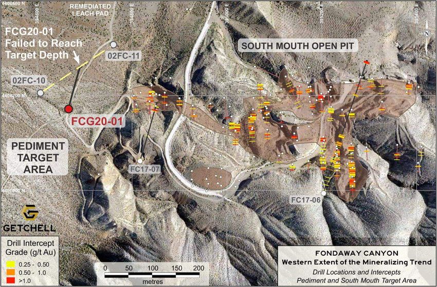
Capital Structure (as at Sept 2020)
                                                                                                                                                         0.50

 • Shares Outstanding: 66.6 M                                                                                                                            0.40

 • Warrants:           22.1 M @ $0.17*                                                                                                                   0.30

 • Stock Options:       5.6 M @ $0.20*
                                                                                                                                                         0.20

                                                                                                                                                         0.10

                                                                      Feb   Mar    Apr   May   Jun       Jul   Aug      Sep    Oct   Nov    Dec    Jan

 Management & Board                                                                              2020                                             2021

     WILLIAM WAGENER                                   MIKE SIEB                                                     Jim Mustard
     Chairman, Chief Executive                         President and Director                                        Independent Director
     Officer and Director

     Mr. Wagener is an internationally experienced     Mr. Sieb has been a director and officer of                   Mr. Mustard is a seasoned capital markets and
     mining executive who has been involved in the     numerous publicly-traded companies over his 30                mining professional, bringing over 30 years of
     exploration, development and operation of         year career with his expertise extending across               expertise in business and project development to
     resource projects across the globe in a variety   multiple commodities and jurisdictions. He is                 the Company.       He was VP of Investment
     of commodities. He has held numerous              currently a Director of various junior mining                 Banking at PI Financial, past President of
     executive positions in publicly traded resource   companies and he is Senior Project Manager for                Canada Zinc Metals and was a VP and Senior
     companies. Mr. Wagener received a Bachelor        the feasibility stage Mariana Lithium Brine                   Mining Analyst at Haywood Securities for 11
     of Science in Mining Engineering from the         Project in Argentina. Mr. Sieb holds an MBA and               years.     In addition to a strong technical
     University of Missouri - Rolla.                   a Bachelor of Science degree in Geology.                      background, he has developed a considerable
                                                                                                                     capital market and investment network. Mr.
                                                                                                                     Mustard is a registered Professional Engineer
                                                                                                                     with the Association of Professional Engineers
* weighted average                                                                                                   and Geoscientists of BC.                    page 3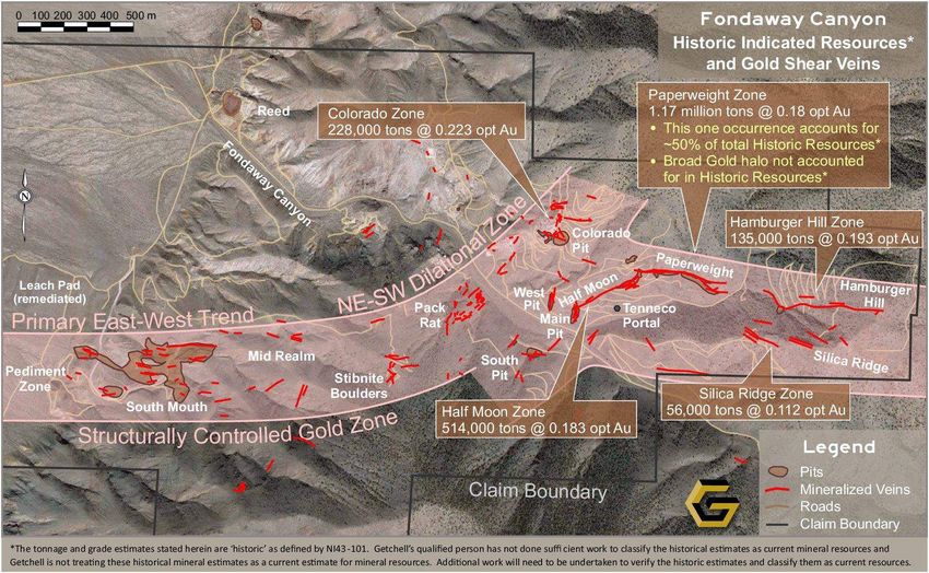
Nevada
                                              Nevada: Impressive Gold Stats*
                                                  • 23 major gold mines
                                                  • Ranked 4th in the world for gold production
                                                  • 5.5 million oz of gold produced annually
                                                  • 152 million oz of gold produced in last 30
                                                     years valued at ~US$280 billion (at today’s
                                                     gold price)

                                            Consistently ranked as one of
                                             Top 5 Mining Jurisdictions
                        Producing                   in the world
                        Gold Mines

                                                                                                   page 4
    *USGS 2017 Annual Report on Gold + Nevada Division of Minerals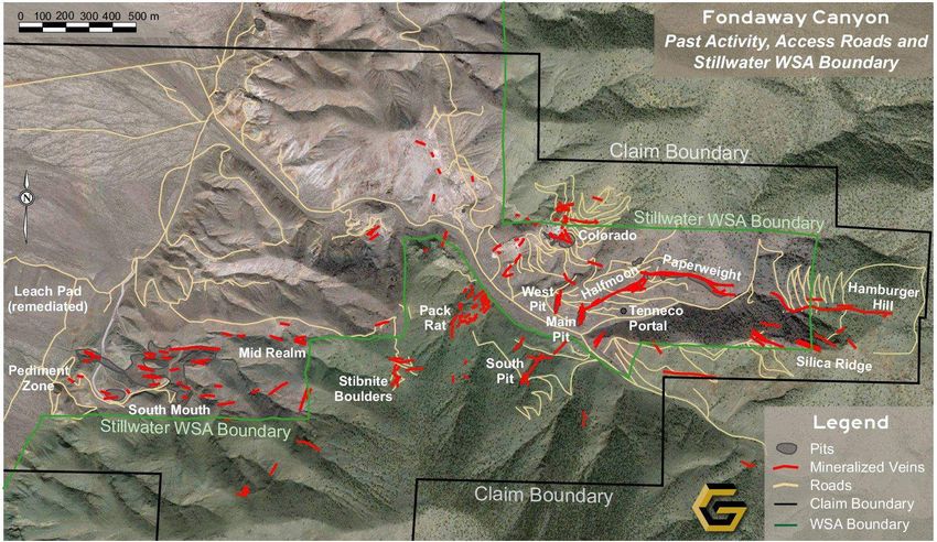
Nevada Projects
                                                                                                                                        Advanced Exploration Projects
                                                                                                                                        with Past Production:
                                                                                                                                         ➢ Fondaway Canyon*
                                                                                                                                         ➢ Dixie Comstock

                                                                                                                                        Active Exploration:
                                                                                                                                         ➢ Star
                                                                                                                                         ➢ Hot Springs Peak

                                                                                                                                       Fondaway Canyon
                                                                                                                                       *Historic Gold Resource Estimate:
                                                                                                                                        ♦ Indicated: 409,000 Oz @ 6.18 Au g/t
                                                                                                                                        ♦ Inferred: 660,000 Oz @ 6.40 Au g/t
* The resource estimate was was completed by Techbase International Ltd of Reno, Nevada, and is contained within a NI 43-101 report dated April 3, 2017 commissioned by Canarc Resource Corp of Vancouver, B.C., Canada.
  compiled from drill holes that could be validated (591 holes @ 49,086 m). Using a method of polygons along each shear vein, a minimum 0.10 opt Au and 1.8 m horizontal vein width was used as cut-off parameters; twelve veins had
  sufficient composited intercepts within the sulfide mineralization for the estimate. No capping or cutting of grades was applied. The historical resource estimate used classifications in accordance with NI 43-101 standards, namely,
  “indicated” and “inferred”. A review and/or re-calculation of the historic resource is required by an independent Qualified Person to confirm these as current resources as defined by NI 43-101. A qualified person has not done sufficient   page 5
  work to classify the historical estimate as current mineral resources; and the issuer is not treating the historical estimate as current mineral resources.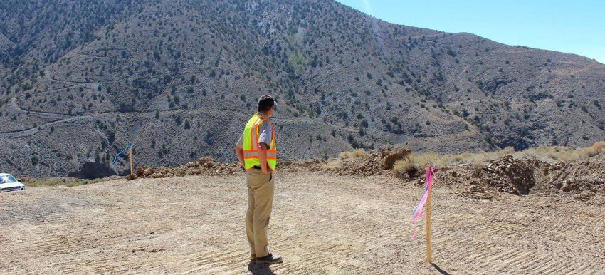
Fondaway 2017 Historic Indicated Resources*

                                              page 6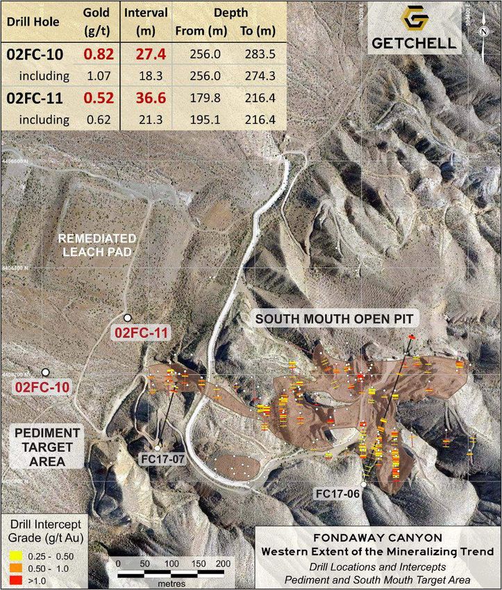
Fondaway Canyon
 East-West Gold Bearing Shear Zone
 with Wide and Well Mineralized
 NE-SW Dilational Zone

                                                                           Plan View
                                                                           3D Looking North

Multiple
Target Areas
Open Along
Strike and at
Depth

                        Exploration Model
                        Showing Gold Mineralized Domains Defined to Date               page 7
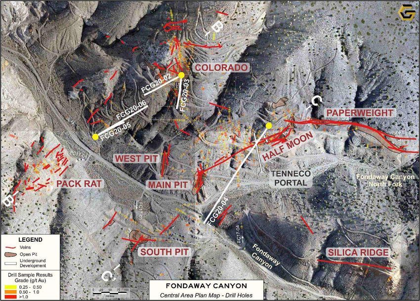
Fondaway 2020 Drill Locations

                                                                                       • Pediment Target Area:
                                                                                        1 Hole (FCG20-01) to
                                                                                        test a broad zone of
                                                                                        gold mineralization
                                                                                        previously intersected
                                                                                        in 2002; and

                                                                                       • Central Target Area:
                                                                                        5 Holes (FCG20-02 to
                                                                                        06) to extend the
                                                                                        known mineralization
                                                                                        and to characterize the
                                                                                        mineralization for
                                                                                        geological and
                                                                                        resource modelling

➢ Six-hole 2,000m drill program completed late 2020: Holes FCG20-01 through FCG20-06
                                                                                                         page 8
Fondaway Canyon - Central Area Panorama

 ➢ Gold Mineralization at Surface

 ➢ Significant Gold Mineralizing System
   with Huge Potential

                       FCG20-03      FCG20-04

Looking Northeast                               Circa 1990   page 9
Fondaway Canyon Central Area – 2020 Drill Program

                                           ➢ Central Area is heart of the
                                             defined gold mineralization
                                             and historic resources

                                           ➢ 2020 Drilling is focused on
                                             two NE-SW gold corridors

                                           ➢ Objective was to
                                             characterize the gold
                                             mineralization, test the
                                             geological model, and
                                             extend the known
                                             mineralization

                                           ➢ Significant area exists to
                                             expand on known gold
                                             mineralization

                                                                        page 10
Long Section - Colorado to Pack Rat ( Circa 2016 )
B’ B
➢ 15% of Total
Historic Resources
at Colorado Zone
➢ Historic Resource
Estimation Overly
Constrained by
High Cut Off Grade
( >3.43 g/t Au )
➢ Homestake Drill
Hole HFC-02 Not
Included in Historic
Resources Due to
Distance from Other
Holes
page 11Long Section - Colorado to Pack Rat ( Circa 2017 )
B’ B
➢ Three Holes Drilled
on this Section in
2017
➢ Significant Intervals
of Gold
Mineralization
Reveal Apparent
Continuity
➢ No Material Change
Until 2020 When
Getchell Options
Property and
Produces New
Geological Model
page 12Long Section - Colorado to Pack Rat ( 2020 )
Colorado
Pit
➢ Three holes drilled
on this section
• FCG20-02,
• FCG20-05, and
• FCG20-06
➢ One hole drilled
oblique to this
section: FCG20-03
page 13Fondaway Canyon Central Area – 2020 Drill Program
Pack
Rat
South
Pit
Good Separation
Between Drill Holes
to Test Broad Zone
of Gold Mineralization
page 14Long Section - Colorado to Pack Rat ( 2020 )
➢ 2020 drill program
was designed to:
o Test geologic model,
o Characterize
mineralization, and
o Extend mineralization
➢ Historic intersections
were NOT twinned
o Note: FCG20-05 was
drilled perpendicular
to HFC-02
page 15Long Section - Colorado to Pack Rat ( Jan 2021 ) FCG20-02
FCG20-03
➢ As projected:
Intersected broad
intervals of gold
mineralization within
the target window
➢ Gold grades are
higher than anticipated
➢ FCG20-03
encountered a
>100m thick overall
zone of gold
mineralization
➢ Successfully extended
the gold mineralization
to the southwest page 16Long Section - Colorado to Pack Rat ( Jan 2021 ) – NEW
ZONE
➢ Unexpectedly
intersected a broad
high grade interval
distinct from known
Gold trends in the
area.
➢ 6.2 g/t Au / 21.9m
Including:
9.6 g/t Au / 12.0m
20.4 g/t Au / 3.2m
➢ Alteration and
mineralization is similar
to the high grade gold
conduits observed
elsewhere on the
property page 17Long Section - Colorado to Pack Rat ( Feb 2021 ) FCG20-05
FCG20-06
➢ Intersected >100m
thick intervals of gold
mineralization within
the target window.
FCG20-05
1.8g/t Au / 90.0m
FCG20-06
1.5g/t Au / 37.7m and
1.1g/t Au / 38.3m
➢ 150m step out
demonstrated
continuity of the
Colorado SW Zone
➢ Open laterally and
down dip page 18Central Area Plan - Colorado SW Extension Potential
Plan View shows the
potential >800 metre
extent of the gold
FC17-01 mineralization:
Intercept
o Extending from surface
at Colorado and down-
dip to the southwest
o Through FCG20-05’s
90m intersection grading
FC17-05
1.8 g/t Au and
o Extending through drill
hole FC17-01’s gold
intercept
page 19FCG20-05 Colorado SW Extension Gold Zone – Core Photo
Brecciated, Bleached with Quartz Stockwork Depth (m) Length (m) Au (g/t)
222.2 – 223.6 1.4 3.1
223.6 – 224.7 1.1 19.2
224.7 – 226.2 1.4 5.5
226.2 – 227.6 1.4 3.7 page 20FCG20-05 Colorado SW Extension Gold Zone – Core Photo
Brecciated, Bleached with Quartz Stockwork Depth (m) Length (m) Au (g/t)
240.5 – 241.4 0.9 2.0
241.4 – 242.4 1.0 10.8
242.4 – 243.5 1.1 1.6
243.5 – 245.0 1.5 5.6
page 21Half Moon Area – Historical + 2020 Drill Program (FCG20-04)
➢ Drill hole FCG20-04 was
collared north of where the
Half Moon Vein is exposed on
surface and drilled to the
southwest.
➢ FCG20-04 was designed to:
o Pierce the Half Moon
Shear Vein to characterize
the mineralization; and
o Extend the gold
FC17-04 mineralization intersected
FC17-05
Intercept in hole FC17-04 down-dip
to the southwest
page 22Half Moon Section – Historic Work
Half Moon Shear Vein ➢ In 1989, Tenneco Minerals Corporation completed 165 metres
at Surface (540 feet) of underground development (adit and drift) to access,
bulk sample and assess the high-grade Half Moon shear vein;
one of the prominent gold mineralized quartz rich shear zones
within the central area of the Project
➢ Gold mineralization in the Half Moon area has been traced for a
375m vertical extent and remains open to depth
Main Pit
(looking NE)
Photographs from left to right – i) Underground development face at the Half Moon shear vein; and
ii) Tenneco adit portal circa 1990. page 231989 UG Drift on Half Moon Shear Vein – Development Face Samples
High Grade Gold
➢ 12.4 g/t Au across full 4.3m width
of the most eastern drift face
(1125E)
➢ 19.4 g/t Au over 3.1 metres,
including 24.1 g/t Au over 1.8 m,
at drift face 1040E
➢ 12.0 g/t Au over 3.2 metres,
including 21.8 g/t Au over 1.5 m,
at drift face 1031E;
➢ The characteristics of the gold
mineralization at Fondaway
support the Company evaluating
the Project’s potential for both
open pit bulk tonnage and high High Grade Gold
grade underground mining
page 24Long Section – Half Moon to South Pit Gold Zones (2020)
C’ 800m C
➢ Hole FCG20-04 drilled
to the SW on the
Paperweight / Half Moon
to South Pit long section
➢ Designed to:
o Pierce the Half Moon
vein to characterize the
mineralization; and
o Extend the gold
mineralization
intersected in hole
FC17-04 down-dip to the
southwest
page 25Long Section – Half Moon + North Fork Gold Zones (Feb 2021)
FCG20-04 800m
Half Moon Shear Vein
➢ Intersected the Half Moon
shear vein 54m vertically
below surface:
o 8.6g/t Au / 9.8m
➢ Further down hole
Intersected two splays to
the Half Moon shear vein:
o 2.7 g/t Au / 9.8m
o 6.3 g/t Au / 3.3m
page 26FCG20-04 Half Moon Shear Vein – Core Photo
Brecciated, Bleached with Quartz Shear Vein Depth (m) Length (m) Au (g/t)
108.1 – 108.8 0.7 16.2
108.8 – 109.8 1.0 9.9
109.8 – 111.0 1.2 9.8
111.0 – 112.2 1.2 8.6
112.2 – 113.4 1.2 13.4 page 27Long Section – Half Moon + North Fork Gold Zones (Feb 2021)
FCG20-04 800m
North Fork Gold Zone
➢ Intersected >100m of gold
mineralization
➢ Intersected:
o 2.5 g/t Au / 58.0m
including
o 3.5 g/t Au / 36.1m; and
o 2.8 g/t Au / 13.4m NEWLY IDENTIFIED
➢ Drill hole FCG20-04 ended
in mineralization
➢ Extended gold zone with
200m step out
➢ Open laterally and down
dip page 28FCG20-04 North Fork Gold Zone – Core Photo
Brecciated, Bleached with Quartz Stockwork Depth (m) Length (m) Au (g/t)
414.6 – 415.8 1.2 9.2
415.8 – 416.5 0.7 22.1
416.5 – 417.5 1.1 10.6
417.5 – 418.6 1.1 6.4
418.6 – 419.8 1.2 7.8 page 29Half Moon + North Fork Gold Zones (Feb 2021)
Central Area (looking North)
FCG20-04
Paperweight
Main
Pit
Fondaway
Canyon
Half Moon Shear Vein
Stockpiles from UG Drift
page 30North Fork Gold Zone
Plan View shows the
potential >800 metre extent
of the gold mineralization:
FC17-01
Intercept
o Starting from surface at
Paperweight and Half
Moon, then extending
down-dip to the southwest;
o along the shallowly dipping
North Fork Gold Zone
NORTH FC17-04 intersected by holes
FC17-05
FORK
Intercept FC17-04 and FCG20-05;
FC17-05 and
Intercept
o Extending through
FC17-05’s gold intercept.
page 31Fondaway Central Area CNSX: GTCH
OTCQB: GGLDF
2020 Drill Program Results Summary
➢ Successfully showed the gold mineralization is thick
and broad, including sizable very high-grade gold
shear structures that are key contributing
characteristics at the Fondaway Canyon Gold Project
➢ Significantly extended the gold mineralization
➢ Revealed the gold mineralization remains open
laterally and down-dip with strong indications that the
mineralization continues, but has yet to be drill tested
➢ Looking to 2021 being a very busy and exciting year
page 32CNSX: GTCH
OTCQB: GGLDF
page 33Getchell Gold Corp.
➢ Fondaway Canyon
• Pediment Target Area
➢ Other Properties
• Star
• Dixie Comstock
APPENDIX
➢ Fondaway Canyon
• Stillwater WSA
• 2017 Drill Intercepts
CNSX: GTCH
OTCQB: GGLDF
page 34Fondaway Canyon Western Extent – Historic Exploration and Mining
Pediment and South Mouth Area
➢ South Mouth Open Pit – 155,000 tonnes oxidized
material mined 1989-1990
➢ Predominately shallow historical drilling
➢ Recent drilling reveals gold at depth and open
➢ Underexplored
Pediment Target Area:
➢ 2002 drilling intersected new gold occurrence
➢ Broad gold intercepts
➢ Distinct ‘Stand Alone’ Carlin style gold
mineralization target
➢ Not followed up until Getchell Gold’s 2020 drill
program
page 35Pediment Target Area: FCG20-01 Drill Site (looking South)
Stillwater Range
Western
Flank
Carson Sinks
page 36Pediment Target Area: FCG20-01 Drill Results
➢ FCG20-01 Targeted the
midway point between the
two gold mineralized
intervals intersected by
holes 02FC-10 and 02FC-
11 to characterize and
model the mineralization
geometry
➢ FCG20-01 was lost within a
fault zone prior to reaching
the target depth
➢ The last series of samples
at the bottom of the hole
showed an increase in gold
values potentially indicative
of the approaching gold
mineralized zone
➢ The plan is to redrill the
Pediment Target during the
next phase of drilling
page 37Getchell Gold – Other Nevada Projects CNSX: GTCH
OTCQB: GGLDF
Star Point
Situated 60 kms north
of Fondaway Canyon
page 38Star Project comprises two main
mineralized occurrences:
Star Point (Cu)
➢Historic near surface, high-grade Copper
oxide (tenorite) mining operation operated
from the late 1940s through the mid-1950s
➢Underlain by a magnetic high anomaly,
possibly indicative of a buried intrusion
Gold Knob
Star South (Cu-Au-Ag)
➢Historic artisanal shallow mining area that
contains at surface high grade Copper-
Gold-Silver mineralization along northeast French Boy
trending faults and along the thrust fault
boundary at surface page 39Star Point (Cu)
➢ Historical development is focused on a
300 x 300 m area comprising various pits,
portals, shafts, open cuts, and associated
dumps
➢ The high-grade copper mineralization is
associated with quartz veins hosted within
shear zones
➢ A 2011 surface sampling program returned
Gold Knob
13 samples grade >0.5% Cu that include 9
samples grading >1% Cu from 79 grab
samples collected
➢ The higher-grade copper samples are
collected from dumps associated with the French Boy
main workings, with the highest reporting
grades of 4.25, 3.00 and 2.35% Cu page 40Star South (Cu-Au-Ag)
➢ Located 2 kms south of the Star Point
Mine and is comprised of a series of pits,
artisanal adits and associated dumps
within a 300 x 150 m E-W trending area
➢ The adits appear to follow high-grade
copper-gold-silver mineralization hosted
within quartz veins associated with shears
➢ A significant portion of the samples
Gold Knob
collected reported impressive grades of
copper, gold and silver in combination
➢ Of the 89 samples collected:
• 40 samples grade >1% Cu
• 21 samples grade >1 g/t Au including French Boy
3 reporting >5 g/t Au, and
• 20 samples grade >30 g/t Ag including
5 reporting >100 g/t Ag. page 41Star South (Cu-Au-Ag)
Notable sampling results sorted by metal weighting:
Sample ID Cu (%) Au (g/t) Ag (g/t)
SP-122 2.45 9.26 310.0
SP-111 4.21 3.44 311.0
SP-088 0.30 9.48 32.3
SP-124 0.81 6.85 193.0
SP-066 3.02 4.08 147.0
SP-105 7.25 0.06 12.6
SP-085 1.97 3.43 151.0
SP-079 0.86 3.40 86.0
SP-086 3.25 1.18 52.0
SP-067 3.78 0.62 43.4
SP-068 0.46 3.59 62.9
SP-075 2.48 1.70 38.7
French Boy
SP-069 2.41 1.71 43.4
SP-108 4.27 0.08 10.0
page 42Star Point
➢ Historic, near surface,
high-grade copper
oxide (tenorite) historic
mining operation
potentially underlain by
a magnetically defined
intrusion containing
high chargeability and
a very strong conductor
(low resistivity target)
Gold Knob
➢ 2020 exploration
program included
additional detailed IP
survey coverage over
the Star Point mine area French Boy
and delineated two
priority targets
page 43Star South
➢ Historic artisanal shallow
mining area that contains
at surface high grade
copper-gold oxide
mineralization (tenorite)
along northeast trending
faults and along the thrust
fault boundary at surface
➢ 2020 exploration program
included additional
detailed IP survey
coverage over the Star
South High-Grade area
and delineated two French Boy
priority targets.
page 44Dixie Comstock Property Overview
➢ Situated 17 kms NE of Fondaway Canyon on the eastern flank of the Stillwater range
➢ Low-sulfidation, epithermal gold system localized along a moderately dipping range-front normal fault
➢ The mine was discovered in 1934 and produced an
estimated 4,600 oz of gold from 10,000 tons of ore during
intermittent operation from 1938 to 1970. Ore grades
ranged from 0.5 to 3.0 opt Au and small pockets of >15 opt Au
ore were mined; all production has taken place within 100 ft
of the present surface (Open Pit and 4 UG levels)*
➢ 1991 Historic Resource estimate**:
✓ 146,000 ounces of gold in 4.26 million tonnes
grading 1.06 g/t Au at a cut-off grade of 0.34 g/t Au
➢ Mineralization remains open down-dip and to the east
* Vikre, Peter G., Gold Mineralization and Fault Evolution at the Dixie Comstock Mine, Churchill County, Nevada; Economic Geology, v. 89, pp. 707-719
**The historic geologic resource estimate was completed by Mine Development Associates of Reno, Nevada, and is contained within a report dated March 1991 commissioned by Horizon Gold Corporation.
The resource estimate was compiled only from drill holes (179 holes totalling 19,679 m), a sufficient amount to deem the historic resource as reliable. The kriged block model was constructed based on a N45E major axis direction with a
30 degree dip and clipped using three separate mineralized zones (high grade, low grade and hot springs mineralization) with a minimum 0.01 opt (0.34 g/t) Au cut-off. No capping or cutting of grades was applied.
The tonnage and grade estimate stated herein is ‘historic’ as defined by NI43-101 and did not use resource classifications in accordance with NI 43-101 standards, instead a single indivisible resource category was defined, a ‘Geologic
Resource’. A qualified person has not done sufficient work to classify the historical estimates as current mineral resources and the qualified person is not treating these historical mineral estimates as a current estimate for mineral
resources. Additional work will need to be undertaken to verify the historic estimates and classify them as current resources. page 45Dixie Comstock Claims & Drill Hole Locations
Project Layout and Drill Holes
Colored by Grade x Thickness
Valley
Selected Drill Hole Composites*
Road
Hole Type gpt Au Interval ft Interval m
2008-2 Core 1.970 225 68.6
82-11 RC 2.165 200 61.0
82-15 RC 3.938 230 70.1
83-26 RC 1.572 330 100.6
84-28 Core 2.440 97 29.6
84-29 Core 6.294 74.5 22.7
86-35 RC 0.734 335 102.1
86-37B RC 4.879 195 59.4
86-43 RC 4.503 225 68.6
86-88 RC 1.547 180 54.9
88-11 RC 1.496 230 70.1
Dixie Comstock
Claims 88-126 RC 1.559 165 50.3
88-14 RC 2.799 185 56.4
88-18 RC 3.947 205 62.5
88-6 RC 5.527 70 21.3
88-8 RC 1.025 210 64.0
14 13 88-9 RC 4.564 125 38.1
23 24 90-24 RC 2.912 150 45.7
0.2 gpt Au cut
BLM
Wilderness Study
Area *These are historic drill results obtained from previous operators. A qualified person for
⚫ 10 m contours
Getchell Gold Corp. has not done sufficient work to confirm these results.
page 46Fondaway Canyon – Past Activity and WSA Boundary
The Fondaway Canyon property is adjacent to and partially overlain by the Stillwater Wilderness Study Area (WSA). Congress mandated the wilderness study
under the Federal Land Policy and Management Act of 1976 (FLPMA). The WSA closed the area within the WSA boundary to mineral entry, which means no
new mining claims can be staked or new activities initiated in that area.
In a statement about Wilderness Study Areas on their website, the BLM states, “Since 1980, Congress has reviewed some of these areas and has designated
some as wilderness and released others for non-wilderness use. Until Congress makes a final determination on a WSA, the BLM manages these areas to
preserve their suitability for designation as wilderness.”
The US Bureau of Land Management issued its final
Environmental Impact Statement EIS) on the Stillwater
WSA in 1987 concluding that, “Under the Proposed
Action, the 94,607 acre Stillwater Range WSA would be
recommended Non-Suitable for wilderness designation”
(BLM, 1987).
Since drilling, road building, mining, and milling
activities were already underway at Fondaway Canyon
when the WSA was established in 1976, these
activities, in the same manner and degree, were
grandfathered under a 1983 determination by the BLM
(BLM, 1983). Past operators (Tundra Gold Mines, Mill
Creek Mining, and Tenneco) constructed roads,
conducted drilling programs and performed other
exploration activities within the WSA boundary under
this determination.
The majority of the known mineralization at Fondaway
Canyon lie outside of the WSA boundary.
page 472017 Drill Hole Gold Intercepts: FC17-01 to FC17-03
Hole Gold ppm From (ft) To (ft) Interval (ft) From (m) To (m) Interval (m)
FC17-1 3.743 248.0 268.0 20.0 75.6 81.7 6.1
including 14.200 251.0 253.0 2.0 76.5 77.1 0.6
and including 5.663 260.0 265.0 5.0 79.2 80.8 1.5
1.658 463.0 491.0 28.0 141.1 149.7 8.5
including 4.747 472.0 476.0 4.0 143.9 145.1 1.2
and including 3.157 481.0 486.0 5.0 146.6 148.1 1.5
1.479 685.0 705.0 20.0 208.8 214.9 6.1
including 6.411 693.0 696.0 3.0 211.2 212.1 0.9
2.102 1047.0 1070.0 23.0 319.1 326.1 7.0
including 3.584 1062.0 1066.5 4.5 323.7 325.1 1.4
1.456 1091.3 1190.0 98.7 332.6 362.7 30.1
FC17-2 2.327 621.0 653.0 32.0 189.3 199.0 9.8
including 3.512 621.0 627.0 6.0 189.3 191.1 1.8
and including 6.106 632.0 637.0 5.0 192.6 194.2 1.5
2.270 660.0 692.0 32.0 201.2 210.9 9.8
including 7.851 660.0 667.0 7.0 201.2 203.3 2.1
1.774 830.5 1037.0 206.5 253.1 316.1 62.9
including 4.392 882.0 893.5 11.5 268.8 272.3 3.5
and including 4.479 932.0 942.5 10.5 284.1 287.3 3.2
and including 6.148 1007.0 1017.0 10.0 306.9 310.0 3.0
FC17-3 0.789 285.0 330.5 45.5 86.9 100.7 13.9
2.828 402.5 617.0 214.5 122.7 188.1 65.4
including 10.200 402.5 407.0 4.5 122.7 124.1 1.4
and including 3.512 416.0 420.0 4.0 126.8 128.0 1.2
and including 3.724 429.0 432.8 3.8 130.8 131.9 1.2
and including 3.017 448.0 453.5 5.5 136.6 138.2 1.7
and including 7.692 507.0 539.0 32.0 154.5 164.3 9.8
and including 7.707 591.0 603.0 12.0 180.1 183.8 3.7
and including 7.062 612.0 617.0 5.0 186.5 188.1 1.5 page 482017 Drill Hole Gold Intercepts: FC17-04 to FC1707
Hole Gold ppm From (ft) To (ft) Interval (ft) From (m) To (m) Interval (m)
FC17-4 1.800 879.0 959.0 80.0 267.9 292.3 24.4
including 6.354 881.0 884.0 3.0 268.5 269.4 0.9
and including 5.578 906.0 911.2 5.2 276.1 277.7 1.6
and including 6.957 936.8 941.0 4.2 285.5 286.8 1.3
2.910 1026.0 1036.3 10.3 312.7 315.9 3.1
including 4.438 1034.0 1036.3 2.3 315.2 315.9 0.7
2.828 1080.0 1107.2 27.2 329.2 337.5 8.3
including 5.908 1095.0 1107.2 12.2 333.8 337.5 3.7
3.344 1302.0 1314.0 12.0 396.8 400.5 3.7
including 6.817 1307.0 1311.5 4.5 398.4 399.7 1.4
0.858 1328.2 1362.0 33.8 404.8 415.1 10.3
including 3.440 1344.0 1348.0 4.0 409.7 410.9 1.2
2.385 1461.0 1475.5 14.5 445.3 449.7 4.4
including 6.786 1466.5 1469.0 2.5 447.0 447.8 0.8
FC17-5 2.713 674.0 686.0 12.0 205.4 209.1 3.7
including 5.191 676.0 681.0 5.0 206.0 207.6 1.5
2.285 705.5 717.1 11.6 215.0 218.6 3.5
including 5.450 708.5 712.5 4.0 216.0 217.2 1.2
4.186 1052.0 1065.0 13.0 320.6 324.6 4.0
including 13.400 1052.0 1055.0 3.0 320.6 321.6 0.9
3.371 1097.0 1110.0 13.0 334.4 338.3 4.0
including 4.576 1097.0 1105.0 8.0 334.4 336.8 2.4
3.479 1133.0 1175.0 42.0 345.3 358.1 12.8
including 5.971 1140.0 1160.0 20.0 347.5 353.6 6.1
and including 3.137 1171.0 1175.0 4.0 356.9 358.1 1.2
FC17-6 0.689 464.5 497.0 32.5 141.6 151.5 9.9
0.625 534.0 561.5 27.5 162.8 171.1 8.4
1.294 1196.0 1216.0 20.0 364.5 370.6 6.1
FC17-7 2.061 531.0 548.0 17.0 161.8 167.0 5.2 FC17-7 lost at top of target zone
including 5.990 536.0 540.0 4.0 163.4 164.6 1.2 page 49You can also read