Japan Manko - Ramsar Information Sheet
←
→
Page content transcription
If your browser does not render page correctly, please read the page content below
RIS for Site no. 996, Manko, Japan

                                     Ramsar Information Sheet
                                     Published on 13 July 2016
                                     Update version, previously published on : 15 May 1999

                                                      Japan
                                                        Manko

                                                             Designation date     15 May 1999
                                                                 Site number      996
                                                                 Coordinates      26°11'44"N 127°41'05"E
                                                                        Area      58,00 ha

https://rsis.ramsar.org/ris/996
Created by RSIS V.1.6 on - 18 May 2020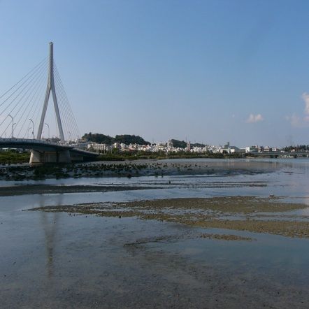
RIS for Site no. 996, Manko, Japan

 Color codes
  Fields back-shaded in light blue relate to data and information required only for RIS updates.
  Note that some fields concerning aspects of Part 3, the Ecological Character Description of the RIS (tinted in purple), are not expected to be
  completed as part of a standard RIS, but are included for completeness so as to provide the requested consistency between the RIS and the
  format of a ‘full’ Ecological Character Description, as adopted in Resolution X.15 (2008). If a Contracting Party does have information available
  that is relevant to these fields (for example from a national format Ecological Character Description) it may, if it wishes to, include information in
  these additional fields.

 1 - Summary
                                       Manko is an estuary tidal flat which is formed at the meeting point of the Kokuba River flowing in Naha
                                       City and Noha River flowing in Tomigusuku City. It is located 3 kilometers upstream inland and is affected
                                       by tidal fluctuations. A maximum of 47 hectares of mudflat appears at low tide. This site is an important
                                       stop-over place for migratory waterbirds because there are abundant juvenile fishes and benthos, such as
                               Summary
                                       fries or lugworms which are specific to blackish tidal flat. Many shorebirds, such as Pacific Golden Plover
                                       (Pluvialis fulva), Dunlin (Calidris alpina) and Eurasian Curlew (Numenius arquata) are often observed.
                                       Threatened and vulnerable species such as Black-faced Spoonbill (Platalea minor), Far Eastern Curlew
                                       (Numenius madagascariensis) and Saunder’s Gull (Larus saundersi) are also observed.

Summary, S1 - Page 1
RIS for Site no. 996, Manko, Japan

 2 - Data & location
 2.1 - Formal data
 2.1.1 - Name and address of the compiler of this RIS
                                            Name      Mr. Manabu Nishimura
                                Institution/agency    Naha Nature Conservation Office, Kyushu Regional Environmental Office, Ministry of the Environment
                                                      1-15-15, Higawa, Naha-shi, Okinawa-ken, 900-0022, JAPAN
                                  Postal address

                                           E-mail     NCO-NAHA@env.go.jp
                                           Phone      +81-98-836-6400
                                               Fax    +81-98-836-6401

 2.1.2 - Period of collection of data and information used to compile the RIS
                                        From year     2005
                                           To year    2014

 2.1.3 - Name of the Ramsar Site
            Official name (in English, French or
                                       Spanish)
                                                      Manko

 2.1.4 - Changes to the boundaries and area of the Site since its designation or earlier update
                                         (Update) A. Changes to Site boundary Yes      No
                                              (Update) B. Changes to Site area No change to area

 2.1.5 - Changes to the ecological character of the Site
   (Update) 6b i. Has the ecological character of the Ramsar Site (including
                                                                                Yes (actual)
                       applicable Criteria) changed since the previous RIS?
                                                       (Update) Are the changes Positive    Negative   Positive & Negative
       (Update) Changes resulting from causes operating beyond the site’s
                                                                  boundaries?
   (Update) Please describe any changes to the        Criterion 6 is no longer applicable because the estimated population size of Black-faced Spoonbill
        ecological character of the Ramsar Site,      (Platalea minor) has been continuously increasing and therefore the number of Black-faced Spoonbills at
      including in the application of the Criteria,   Manko now falls below 1% of its current population size.
             since the previous RIS for the site.
    (Update) Is the change in ecological character negative, human-induced
                                                                                Yes
           AND a significant change (above the limit of acceptable change)

 2.2 - Site location
 2.2.1 - Defining the Site boundaries
 b) Digital map/image

                                                      Boundary of Manko is the same as that of the Special Protection Area within the Manko National Wildlife
              Boundaries description (optional)
                                                      Protection Area, following the boundaries of the roads and the rivers.

 2.2.2 - General location
   a) In which large administrative region does
                                     the site lie?
                                                      Naha City and Tomigusuku City, Okinawa Prefectue

      b) What is the nearest town or population
                                       centre?
                                                      The Center of Naha City, Okinawa Prefecture

 2.2.3 - For wetlands on national boundaries only
          a) Does the wetland extend onto the territory of one or more other
                                                                             Yes       No
                                                                  countries?

Data & location, S2 - Page 1
RIS for Site no. 996, Manko, Japan
b) Is the site adjacent to another designated Ramsar Site on the
Yes No
territory of another Contracting Party?
2.2.4 - Area of the Site
Official area, in hectares (ha): 58
Area, in hectares (ha) as calculated from
GIS boundaries
58.53
2.2.5 - Biogeography
Biogeographic regions
Regionalisation scheme(s) Biogeographic region
Udvardy's Biogeographical The Palaearctic Realm, Ryukyu islands, Mixed island System
Provinces
Data & location, S2 - Page 2RIS for Site no. 996, Manko, Japan
3 - Why is the Site important?
3.1 - Ramsar Criteria and their justification
Criterion 2 : Rare species and threatened ecological communities
Criterion 4 : Support during critical life cycle stage or in adverse conditions
3.2 - Plant species whose presence relates to the international importance of the site
3.3 - Animal species whose presence relates to the international importance of the site
Species Species
qualifies contributes IUCN CITES CMS
under under Pop. %
Phylum Scientific name Common name Period of pop. Est. occurrence Red Appendix Appendix Other Status Justification
criterion criterion Size List I I
2 4 6 9 3 5 7 8
CHORDATA Chroicocephalus VU
/ saundersi Saunders's Gull VU on Japan Red List A key staging site
AVES
CHORDATA Falco peregrinus VU on Japan Red List, Nationally Endangered Species (the Law
LC for the Conservation of Endangered Species of Wild Fauna and
/ Peregrine Falcon
AVES Flora, the Government of Japan)
CHORDATA Numenius Eastern EN
/ madagascariensis Curlew;Far VU on Japan Red List A key staging site
AVES Eastern Curlew
CHORDATA Platalea minor Black-faced EN
/ EN on Japan Red List, A key staging site
Spoonbill
AVES
CHORDATA Sternula albifrons VU on Japan Red List, International Endangered Species (the
LC Law for the Conservation of Endangered Species of Wild Fauna
/ Little Tern
AVES and Flora, the Government of Japan)
3.4 - Ecological communities whose presence relates to the international importance of the site
Why is the Site important?, S3 - Page 1RIS for Site no. 996, Manko, Japan
4 - What is the Site like? (Ecological character description)
4.1 - Ecological character
This brackish tidal flat is located approximately 3 kilometers upstream from the mouth of two rivers, lined
by mangroves mostly consisted of Kandelia ovobata . Mangroves cover approximately 7 hectares. The
climate is warm and constant with no distinct seasonal changes, but the mangrove trees bloom and/or
produce viviparous seeds during spring and summer. The mudflats exposed at low tide are the habitat for
an abundance of benthos and fishes, including crabs, lugworms, gray mullets and tilapias, which provide
the birds with food.
4.2 - What wetland type(s) are in the site?
Marine or coastal wetlands
Wetland types (code and Local name Ranking of extent (1: greatest - 4: least) Area (ha) Justification of Criterion 1
name) of wetland type
F: Estuarine waters 1 30
G: Intertidal mud, sand or 2 28
salt flats
4.3 - Biological components
4.3.1 - Plant species
Other noteworthy plant species
Scientific name Common name Position in range / endemism / other
Bruguiera gymnorhiza
Kandelia obovata
Rhizophora mucronata
4.3.2 - Animal species
Other noteworthy animal species
Phylum Scientific name Common name Pop. size Period of pop. est. %occurrence Position in range
/endemism/other
Acentrogobius VU on Japan Red List
CHORDATA/ACTINOPTERYGII viridipunctatus
Auriculodes incrassatum CR on Japan Red List
MOLLUSCA/GASTROPODA
Blauneria quadrasi VU on Japan Red List
MOLLUSCA/GASTROPODA
Butastur indicus Grey-faced Buzzard VU on Japan Red List
CHORDATA/AVES
Charadrius alexandrinus Kentish Plover;Snowy VU on Japan Red List
CHORDATA/AVES Plover
Cybister tripunctatus VU on Japan Red List
ARTHROPODA/INSECTA lateralis
Himantopus himantopus Black-winged Stilt VU on Japan Red List
CHORDATA/AVES
Japalura polygonata VU on Japan Red List
CHORDATA/REPTILIA polygonata
Laemodonta siamensis VU on Japan Red List
MOLLUSCA/GASTROPODA
Lanius cristatus Brown Shrike EN on Japan Red List
CHORDATA/AVES
Pericrocotus divaricatus Ashy Minivet VU on Japan Red List
CHORDATA/AVES
Plestiodon marginatus VU on Japan Red List
CHORDATA/REPTILIA marginatus
Tadorna tadorna Common Shelduck VU on Japan Red List
CHORDATA/AVES
Taenioides cirratus EN on Japan Red List
CHORDATA/ACTINOPTERYGII
Taenioides limicola VU on Japan Red List
CHORDATA/ACTINOPTERYGII
Tringa totanus eurhina Common Redshank VU on Japan Red List
CHORDATA/AVES
4.4 - Physical components
4.4.1 - Climate
Climatic region Subregion
C: Moist Mid-Latitude Cfa: Humid subtropical
climate with mild winters (Mild with no dry season,
hot summer)
More on climate: Average temperature is 22.3 degrees Celsius. Annual rainfall is 2087.1 mm (average
from 1891 to 2011).
4.4.2 - Geomorphic setting
What is the Site like?, S4 - Page 1RIS for Site no. 996, Manko, Japan
a) Minimum elevation above sea level (in
metres)
0
a) Maximum elevation above sea level (in
metres)
0
More than one river basin
Coastal
Please name the river basin or basins. If the Manko is an estuary tidal flat which is formed at the meeting point of the Kokuba River flowing in Naha
site lies in a sub-basin, please also name City and Noha River flowing in Tomigusuku City. It is located 3km upstream inland and affected by tidal
the larger river basin. For a coastal/marine fluctuations.
site, please name the sea or ocean.
4.4.3 - Soil
Mineral
(Update) Changes at RIS update No change Increase Decrease Unknown
Organic
(Update) Changes at RIS update No change Increase Decrease Unknown
No available information
Are soil types subject to change as a result of changing hydrological
Yes No
conditions (e.g., increased salinity or acidification)?
Please provide further information on the Soil type is mainly clay (montmorillonite illite, kaolinite).
soil (optional)
4.4.4 - Water regime
Water permanence
Presence? Changes at RIS update
Usually permanent water No change
present
Source of water that maintains character of the site
Presence? Predominant water source Changes at RIS update
Water inputs from surface No change
water
Marine water No change
Water destination
Presence? Changes at RIS update
Marine No change
Stability of water regime
Presence? Changes at RIS update
Water levels fluctuating No change
(including tidal)
Please add any comments on the water Water depth is 2 m at the average tidal level. Tidal variation: Average tidal level alt. 5.2 cm, average high
regime and its determinants (if relevant). tidal level alt. 98 cm, average low tidal level alt. -111.8 cm (at Naha part, from 2006 to 2010).
Use this box to explain sites with complex Hydrology: Inflow and outflow 326,061 m3/day (March 12 - 13, 1998).
hydrology:
4.4.5 - Sediment regime
(Update) Changes at RIS update No change Increase Decrease Unknown
(Update) Changes at RIS update No change Increase Decrease Unknown
(Update) Changes at RIS update No change Increase Decrease Unknown
(Update) Changes at RIS update No change Increase Decrease Unknown
Sediment regime unknown
Please provide further information on An alluvium of Holocene sediment is ranged in this area and local Ryuku limestones are also found. The
sediment (optional): alluvium along Kokuba River is vast and some of the layers are around 15 to 20 m thick.
4.4.6 - Water pH
(Update) Changes at RIS update No change Increase Decrease Unknown
(Update) Changes at RIS update No change Increase Decrease Unknown
Alkaline (pH>7.4)
(Update) Changes at RIS update No change Increase Decrease Unknown
Please provide further information on pH pH 7.2 - 8.1 (at Naha Ohashi Bridge, 2010).
(optional):
4.4.7 - Water salinity
Mixohaline (brackish)/Mixosaline (0.5-30 g/l)
(ECD) Dissolved gases in water DO 3.6 - 6.5 mg/L (at Naha Ohashi Bridge, 2010).
4.4.8 - Dissolved or suspended nutrients in water
Eutrophic
What is the Site like?, S4 - Page 2RIS for Site no. 996, Manko, Japan
(ECD) Dissolved organic carbon
BOD < 0.5 - 2.9 mg/L (at Naha Ohashi Bridge, 2010).
4.4.9 - Features of the surrounding area which may affect the Site
Please describe whether, and if so how, the landscape and ecological
characteristics in the area surrounding the Ramsar Site differ from the i) broadly similar ii) significantly different
site itself:
Surrounding area has greater urbanisation or development
Surrounding area has higher human population density
Surrounding area has more intensive agricultural use
The upstream part and middle stream part of the catchment area are agricultural fields and the
downstream part is mostly cities. The catchment is covered with Shimajiri layer mudstones and the
Jahgaru soil which is made by weathering of the mudstones distributed widely over the catchment. The
Please describe other ways in which the
climate in the catchment area is the same as Manko and its surrounding areas. The mean annual rainfall
surrounding area is different:
in the catchment is ca.1,900mm. Regarding geographical features, there are mostly rolling hills with less
than 100m difference of elevation, and most of the rainwater flows into rivers because there are few areas
to accumulate rainwater on the ground.
4.5 - Ecosystem services
4.5.1 - Ecosystem services/benefits
Provisioning Services
Ecosystem service Examples Importance/Extent/Significance
Food for humans Sustenance for humans Medium
(e.g., fish, molluscs, grains)
Regulating Services
Ecosystem service Examples Importance/Extent/Significance
Erosion protection Soil, sediment and nutrient Medium
retention
Cultural Services
Ecosystem service Examples Importance/Extent/Significance
Recreation and tourism Nature observation and
nature-based tourism
Scientific and educational Educational activities and Medium
opportunities
Important knowledge
Scientific and educational systems, importance for
research (scientific
reference area or site)
Scientific and educational Major scientific study site
Supporting Services
Ecosystem service Examples Importance/Extent/Significance
Supports a variety of all life
forms including plants,
animals and
Biodiversity microorganizms, the genes Medium
they contain, and the
ecosystems of which they
form a part
Other ecosystem service(s) not included More on Provisioning services: Fisheries of mangrove crabs, Scylla serrata and Scylla olivacea, are
above: conducted here for livelihoods in an inland water area.
Have studies or assessments been made of the economic valuation of
Yes No Unknown
ecosystem services provided by this Ramsar Site?
4.5.2 - Social and cultural values
4.6 - Ecological processes
What is the Site like?, S4 - Page 3RIS for Site no. 996, Manko, Japan
5 - How is the Site managed? (Conservation and management)
5.1 - Land tenure and responsibilities (Managers)
5.1.1 - Land tenure/ownership
Public ownership
Category Within the Ramsar Site In the surrounding area
Provincial/region/state
government
Local authority,
municipality, (sub)district,
etc.
Public land (unspecified)
Private ownership
Category Within the Ramsar Site In the surrounding area
Other types of
private/individual owner(s)
Provide further information on the land The whole area of the Ramsar Site is public water.
tenure / ownership regime (optional):
5.1.2 - Management authority
Please list the local office / offices of any Naha Nature Conservation Office, Kyushu Regional Environmental Office, Ministry of the Environment
agency or organization responsible for
managing the site:
Provide the name and title of the person or
people with responsibility for the wetland:
Mr. Manabu Nishimura
1-15-15, Higawa, Naha-shi, Okinawa-ken, 900-0022, JAPAN.
Postal address:
Tel: +81-98-836-6400, Fax:+81-98-836-6401
E-mail address: NCO-NAHA@env.go.jp
5.2 - Ecological character threats and responses (Management)
5.2.1 - Factors (actual or likely) adversely affecting the Site’s ecological character
Human settlements (non agricultural)
Factors adversely Actual threat Potential threat Within the site Changes In the surrounding area Changes
affecting site
Housing and urban Medium impact No change unknown
areas
Transportation and service corridors
Factors adversely Actual threat Potential threat Within the site Changes In the surrounding area Changes
affecting site
Roads and railroads Medium impact Medium impact unknown unknown
Natural system modifications
Factors adversely Actual threat Potential threat Within the site Changes In the surrounding area Changes
affecting site
Vegetation clearance/ Medium impact unknown unknown
land conversion
Invasive and other problematic species and genes
Factors adversely Actual threat Potential threat Within the site Changes In the surrounding area Changes
affecting site
Problematic native High impact increase No change
species
Pollution
Factors adversely Actual threat Potential threat Within the site Changes In the surrounding area Changes
affecting site
Garbage and solid Medium impact unknown No change
waste
More on vegetation clearance/land conversion:
Please describe any other threats (optional):
- Rapid expansion of afforested mangrove and parching of tidal flat by sediment within the Ramsar Site.
5.2.2 - Legal conservation status
How is the Site managed?, S5 - Page 1RIS for Site no. 996, Manko, Japan
National legal designations
Designation type Name of area Online information url Overlap with Ramsar Site
Special Protection Area of National Manko Special Protection Area within
Wildlife Protection Area Manko National Wildlife Protection Area whole
Non-statutory designations
Designation type Name of area Online information url Overlap with Ramsar Site
Important Bird Area Manko tidal flat
whole
Other non-statutory designation Manko (500 important wetlands in
Japan(2002)) whole
5.2.3 - IUCN protected areas categories (2008)
IV Habitat/Species Management Area: protected area managed mainly
for conservation through management intervention
5.2.4 - Key conservation measures
Legal protection
Measures Status
Legal protection Implemented
Human Activities
Measures Status
Harvest controls/poaching Implemented
enforcement
Communication, education,
and participation and Implemented
awareness activities
Research Implemented
More on legal protection: Manko is designated as Special Wildlife Protection Area under the “Law for the
Other:
Protection of Birds and Mammals and Hunting" of Japan. In this area, capture of wild birds and mammals,
installation of artificial structures, reclamation of water body, and tree logging are prohibited without
permission by the Minister of the Environment, Japan.
5.2.5 - Management planning
Is there a site-specific management plan for the site? Yes
Has a management effectiveness assessment been undertaken for the
Yes No
site?
If the site is a formal transboundary site as indicated in section Data
and location > Site location, are there shared management planning Yes No
processes with another Contracting Party?
There is "Manko Waterbird and Wetland Center" next to the site. Students from the mainland of Japan
visit the center as part of schoo trip;
Manko Churakagi (cleaning) Event for general public (once a year) including cleaning activities and nature
observation programs: 100–200 participants;
Please indicate if a Ramsar centre, other Kokuba River Mizu Ashibi Event for general public (once a year) including cleaning activities and nature
educational or visitor facility, or an observation programs: ca.160 participants;
educational or visitor programme is Workshop for wise use of Manko by Manko Natural Environment and Conservation Liaison Council;
associated with the site: Environmental Meeting by Children in Okinawa (once a year) participated by ca.20 children who take part
in conservation activities in Ramsar sites of Okinawa;
Bird watching and nature observation programs of benthos such as fishes or crabs in mud with
interpretation by experts, experience-based water quality survey, dyeing program using mangrove,
lectures on nature and sampling of live creatures for parents and their children, etc. are often conducted.
5.2.6 - Planning for restoration
Is there a site-specific restoration plan? Yes, there is a plan
5.2.7 - Monitoring implemented or proposed
Monitoring Status
Plant community Implemented
Animal community Implemented
Birds Implemented
How is the Site managed?, S5 - Page 2RIS for Site no. 996, Manko, Japan
6 - Additional material
6.1 - Additional reports and documents
6.1.1 - Bibliographical references
2012 Measurement result of water quality, Okinawa Prefecture
2007 Revised plan of official Manko Wildlife Protection Area, Ministry of the Environment, Japan
2005 Revised Red Data Okinawa, threatened wildlife in Okinawa Prefecture, Okinawa Prefecture
2008 Report of Conservation project examination and survey in Manko National Wildlife Protection Area,
Ministry of the Environment, Japan
6.1.2 - Additional reports and documents
i. taxonomic lists of plant and animal species occurring in the site (see section 4.3)
ii. a detailed Ecological Character Description (ECD) (in a national format)
iii. a description of the site in a national or regional wetland inventory
iv. relevant Article 3.2 reports
v. site management plan
vi. other published literature
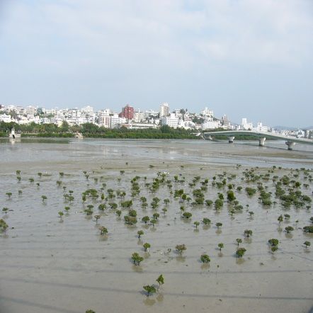
6.1.3 - Photograph(s) of the Site
Please provide at least one photograph of the site:
Manko from Haryu Bridge ( Manko from Toyomi Bridge (
Ministry of Environment, the Ministry of Environment, the
Government of Japan, 20-12- Government of Japan, 02-02-
2005 ) 2006 )
6.1.4 - Designation letter and related data
Designation letter
Transboundary Designation letter
Date of Designation 1999-05-15
Additional material, S6 - Page 1You can also read