Kennett Greenway Chandler Mill Road - Design and Engineering Task Order No. 9
←
→
Page content transcription
If your browser does not render page correctly, please read the page content below

Kennett Greenway
Chandler Mill Road

Design and Engineering
   Task Order No. 9

Kennett Greenway Chandler Mill Road Design & Engineering
        Task Order No. 9
 Final Design and Engineering
Welcome to the technical part of
           the show.

  • $628,397.00
  • Preliminary Engineering +
    Final Design and
    Engineering = 16% of
    Construction Estimate
  • 6/7 Months to Complete
  • Engages Permitting Agencies
  • Includes Pilot Project
  • Some Focused Public
    Engagement
  • List of Exceptions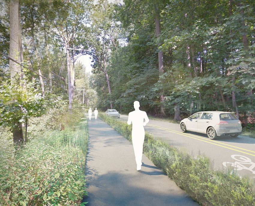
How can we pay for the Chandler Mill Trail & 5-Points?

                                                                                                                                                                                        Kennett Greenway Chandler Mill Road Design & Engineering
There are many potential funding sources that can be combined into final plan. It is assumed that these are the prioritized projects through 2024. They will not leave substantial funds for
other large General Fund projects without additional funding sources (e.g. Magnolia underpass or South St. engineering & construction). We do anticipate Sewer projects & Open Space
purchases as they are funded separately.

 FUNDING PLAN FOR CHANDLER MILL TRAIL & 5-POINTS

 Cost of Prioritized Projects for 2021-2024
 Chandler Mill Trail                                            $5,196,000
 5-Points Roundabout                                            $3,133,643
                                                                $8,329,643

 Grant Funding
 Greenway Grant remaining                                       $1,343,542
 5-Points Roundabout Grant                                      $2,193,550
                                                                $3,537,092
 Funding Required                                               $4,792,551

 Funding Sources - Known
 Budgeted as use of annual operating revenue (2021)               $230,000
 Budget overage 2021 (funded specifically from                    $350,000
 reimbursement of grant expenses paid in 2020)
 Use of Traffic Impact Fees for 5-points                           $77,000
 Use of Fee In Lieu of Open Space for Chandler Mill                $42,000
 Total Funding Sources - Known                                    $699,000
 Remaining Funding Needed                                       $4,093,551
 Other Potential Funding Sources
                                                                             There are many factors that will
 Budgeted as use of annual operating revenue (2022+)                         drive the final combination of
 Use of Reserves                                                             funding sources. To be
 Use of Loan Proceeds (existing loan or new)                                 discussed as the project
 Use of Open Space Funds (maintenance portion; full analysis to be           progresses.
 American Recovery Act Funding (pending further grants) or other grants
May 12, 2021

Township of Kennett, Chester County
801 Burrows Run Road
Chadds Ford, PA 19317

RE: Proposal for Task Order 9 - Task Order 9 – Full Design Services Chandler Mill Road Greenway
Segment

Dear Eden,

Following this letter is our proposal for Task Order 9 under the current Master Services Agreement.

If you have any questions regarding this scope of work, please contact me by phone 667-401-8472
or by email at jdowdell@biohabitats.com. If this proposed scope and fee, are acceptable, please
sign below to fully execute the Agreement and give formal notice to proceed.

Once signed, please return a copy of the full Agreement to: contracts@biohabitats.com or to the
mailing address above.

Sincerely,
Biohabitats, Inc.

                                       Jennifer Dowdell, Project Manager May 12, 2021
_____________________________             _____________________________     ________
Signature                                 Name, Title                       Date

Client: Township of Kennett
Execution of this Task Order authorizes Biohabitats to initiate the Work Plan in accordance with the
Scope of Work, Schedule, Fee and terms as provided in the Master Services Agreement dated
June 3, 2020. If this Agreement is not accepted within 30 days from the date of receipt, the offer to
perform the described Services may be withdrawn and Biohabitats may renegotiate this proposal.

_____________________________              _____________________________              ________
Signature                                  Name, Title                                Date

©Biohabitats, Inc.

                                                 1
SCOPE AND FEE PROPOSAL
Task Order 9 – Full Design Services Chandler Mill Road Greenway Segment
Township of Kennett Master Services Agreement – Kennett Greenway
May 12, 2021
TASK ORDER 9 UNDERSTANDING
The project team will prepare full design documents appropriate for Kennett Township’s use to put out
to bid the Chandler Mill Road Greenway Segment. This task order includes associated public
engagement and team coordination and meetings with the client, community, and relevant permitting
agencies. The basis of design for the scope outlined herein is the previous due diligence efforts (Task
Order 4) and the preliminary engineering study completed under Task Order 7. All activities presented in
this proposal are interrelated and must be accepted and executed as a singular scope of work. There is
no phasing or task breakdown associated with this scope of work as all items have the potential to be
performed and invoiced concurrently. Additional bid documents under a separate scope of work would
be required to phase construction, if deemed necessary. The client for this project is Kennett Township,
with Christina Norland (Square Roots Collective) serving as the owner’s representative/project manager
for the client.
SCOPE OF WORK
1. Biohabitats will act as consultant team project manager and provide input on ecological
considerations for the Chandler Mill Road Greenway Segment advising on native plant palette and
providing insights on wetland delineation. The bulk of this final design effort is led by team
subconsultants: McMahon Associates (with specialized subconsulting provided by GeoStructures
and Lotus Environmental) with design support from Unknown Studio and permitting and
stormwater management support from Meliora.
2. Members of the project team will participate in select meetings to support the following:
a. Internal team coordination
b. Permitting and agency meetings
c. Coordination with the Township
d. Public engagement sessions (2)
3. The Client shall provide the following information or services within 7 days of notice to proceed, as
required for performance of its services outlined herein:
a. Coordination in support of pilot project implementation as described below
b. Right of way acquisition coordination
c. Contact with public safety, fire, and emergency services as needed
d. Coordination on utility relocation as needed
e. Permission from private property owner(s) for Biohabitats to perform additional wetland
delineation on their property as described below.
f. Permit application fees, when due
4. Biohabitats will perform a routine wetland delineation to supplement the delineation conducted in
November 2020 along Chandler Mill Road, document the formal wetland delineation results by
revising the November 30, 2020, memorandum, and coordinate with surveyor.
5. Exclusions and expectations for Township support on certain scope items are listed within the work
plan in bold italics.
© Biohabitats, Inc. Restore the Earth and Inspire Ecological Stewardship 1SCOPE AND FEE PROPOSAL Task Order 9 – Full Design Services Chandler Mill Road Greenway Segment Township of Kennett Master Services Agreement – Kennett Greenway May 12, 2021 6. The scope of work does not include identification, assessment, or remediation of hazardous, toxic, or radioactive waste. 7. Revisions and changes in graphics and documents, when such revisions are inconsistent with approvals or instructions previously given by the client; required by the enactment or revision of codes, laws, or regulations subsequent to the preparation of such documents; or the preparation of alternates or deductive change orders requested by the client, shall be considered extra services and may require adjustments to the fee and schedule. 8. The services to be performed pursuant to this agreement are strictly limited to those expressly set forth herein. No additional services will be provided unless requested and agreed to in writing. 9. This proposed scope and fee is valid for a period of 60 days, after which it may be negotiated. © Biohabitats, Inc. Restore the Earth and Inspire Ecological Stewardship 2
SCOPE AND FEE PROPOSAL
Task Order 9 – Full Design Services Chandler Mill Road Greenway Segment
Township of Kennett Master Services Agreement – Kennett Greenway
May 12, 2021

PROPOSED WORK PLAN
DESIGN DEVELOPMENT
The final design will be based on the Preliminary Engineering Evaluation for the Greenway Trail along
Chandler Mill Road, dated March 5, 2021, submitted by McMahon Associates, Inc.

The following design guidelines and publications will be utilized for the final design and preparation of
plans:
    a. PennDOT Design Manual, Part 2 (DM-2): Highway Design, Publication 13M, March 2015 Edition
    b. A Policy on Geometric Design of Highways and Streets (Green Book), Sixth Edition (2011),
        America Association of State Highway and Transportation Officials (AASHTO)
    c. Guide for the Planning, Design and Operation of Pedestrian Facilities, (2004), American
        Association of State Highway and Transportation Officials (AASHTO)
    d. Pennsylvania’s Traffic Calming Handbook (2012), PennDOT Publication 383
    e. Guide for the Development of Bicycle Facilities (2012), American Association of State Highway
        and Transportation Officials (AASHTO) or latest revisions to these guidelines.

Initial Permitting Agency Meeting
Meliora will lead the coordination of the initial Joint Permit Pre‐Application meeting with PaDEP, US COE
(Army Corps of Engineers) and any other agencies PaDEP identifies as relevant to the Pre‐application
meeting. Since work portions of the trail will be constructed in the Floodway and Floodplain, our team
recommends that this meeting occur as soon as it can be scheduled before other work is begun in this
scope. This is the Township’s opportunity to review the Schematic Design (developed during Preliminary
Engineering task order) with the agencies, confirm the anticipated permitting requirements, and identify
if there are any issues or concerns from the regulatory perspective that could impact the proposed
design.

Supplemental Topographic Survey & Additional Wetland Delineation
McMahon will supplement the topographic survey that was completed during the preliminary
engineering phase as follows:
    1) Detailed floodway cross sections at sixteen (16) critical locations along Red Clay Creek; floodway
       and embankment cross sections along the length of three (3) washout embankment areas and
       survey of the hydraulic opening of the Brokaw property bridge and Chandler Mill Road bridge
       for the purpose of completing the Hydrologic and Hydraulic Study for the project.
    2) Additional downstream data at each drainage pipe outfall.
    3) Detailed survey of the TLC nature trail and mill race historic boundary.
    4) Supplemental topographic survey within project areas of anticipated steep fills or significant
       observable stream erosion.
    5) Completion of a final Right-of-way and property line mosaic for the five (5) properties that
       require right-of-way acquisition.

© Biohabitats, Inc.            Restore the Earth and Inspire Ecological Stewardship                         3
SCOPE AND FEE PROPOSAL
Task Order 9 – Full Design Services Chandler Mill Road Greenway Segment
Township of Kennett Master Services Agreement – Kennett Greenway
May 12, 2021
6) Stakeout of the geotechnical borings.
Biohabitats will perform a routine wetland delineation to supplement the delineation conducted in
November 2020 along Chandler Mill Road within the vicinity of the proposed trail. This supplemental
wetland delineation will target the east side of Chandler Mill Road opposite Wetland W3 (Biohabitats’
November 30, 2020 Wetland Delineation Memo) and, as needed, any areas noted by state or federal
regulators during the initial permitting meeting. Biohabitats assumes that the limits of the supplemental
wetland delineation will not extend further than 50 feet beyond the proposed trail. The formal wetland
delineation boundary and documentation will be consistent with the 1987 Corps of Engineers Wetlands
Delineation Manual -Technical Report 87-1 (ACE 1987) and the 2012 Corps of Engineers Regional
Supplement to the Corps of Engineers Wetland Delineation Manual: Eastern Mountains and Piedmont
Region (Version 2.0). Biohabitats will hang wetland delineation flagging along all delineated wetlands
and enumerate the flags. All flags within the proposed survey limits will be surveyed by McMahon
team’s licensed surveyor. The wetland flag locations will also be field-located using a handheld
Differential GPS unit capable of achieving sub-meter precision.
Biohabitats will document the finding of the supplemental wetland delineation by revising Biohabitats’
November 30, 2020 Wetland Delineation Memorandum. The memorandum will be revised to include a
revised map of the delineated features (using GPS wetland flagging points) as well as any photographs
and data forms from the supplemental delineation. Biohabitats will also provide a GIS shapefile of
wetland delineation flag locations and the delineated wetlands. Biohabitats will coordinate with the
surveyor on the wetland delineation field work schedule and flag locations via phone calls and/or email.
One Lane/Two Way Pilot
McMahon will work with the Township to set-up the temporary One Lane/Two Way configurations at
both locations shown on the Preliminary Engineering Evaluation. Our team will provide sketches and
mark-outs of the temporary configuration in the field, as well as a tabulation of the required signs and
traffic control devices. This task will involve multiple field visits for the initial implementation and
observation once the configuration is in operation. McMahon will record and process the operation of
the temporary One Lane/Two Way configuration with Miovision cameras and will measure the traffic
volumes and speeds within the One Lane/Two Way configuration. Our team will evaluate the data for
two (2) peak periods and summarize the results. The Township will be responsible for the furnishing of
all materials and labor for the temporary installation. The Township or Owner Representative will also
be responsible for any additional qualitative evaluations and for gauging public opinion on the One
Lane/Two Way Pilot.
Landscape Architectural Design Development
Unknown Studio will provide the lead design on placemaking and landscape architecture supporting
McMahon and Meliora. The landscape architecture scope specifically includes design and Design
Development level documentation of:
• Boardwalks
• Planting Median, Riparian Planting & Viewshed Design
© Biohabitats, Inc. Restore the Earth and Inspire Ecological Stewardship 4SCOPE AND FEE PROPOSAL
Task Order 9 – Full Design Services Chandler Mill Road Greenway Segment
Township of Kennett Master Services Agreement – Kennett Greenway
May 12, 2021
• Gateway Design (in coordination with traffic engineer)
• Planting Design
• Soils Recommendations (in coordination with stormwater engineer)
• Paving Material Recommendations (build up and profile specifications by Civil)
• Key Placemaking Details (overlooks, fixtures, medians)
• Furnishings, fencing, fixtures
In addition, Unknown Studio will support schematic level studies looking at any rerouting of the trail in
order to avoid key trees. Unknown Studio will participate in a one-time Value Engineering process.
Unknown Studio will also take a primary role in preparing presentations to the Township and key
stakeholders in this Phase Unknown can prepare the following in support of design development: up to
4-eye level renderings; SD-level trail studies; monthly Slide Deck exported to pdf format; Draft DD Set*
for Coordination; 100% DD Set* for Coordination and Client Review (*Title Block, Base CAD, Survey
coordination will be by others. Unknown Studio will provide landscape sheets in plan and detail / section
for key placemaking and enlarged plans only), and DD Level Specifications.
Geotechnical Engineering
For geotechnical investigation and design purposes, the preliminary design has designated a total of ten
(10) reinforced slope embankments on the plans with the understanding that these will be optimized
and revised based on the findings and progression of design factors, while some portions could possibly
be augmented or eliminated during final design. Certain critical areas may require the use of retaining
walls due to their stream setting, active bank erosion, and other existing conditions. Other sections will
be built alongside existing wetlands featuring soft, organic soil deposits and shallow groundwater levels.
Except for reinforced slope embankment #1 which has a reinforced and total height of 15 ft, the slopes
on the preliminary plans have a maximum reinforced height of 5 ft. Also, reinforced slope embankment
#4 could require additional, larger-scale fills if an alignment which deviates farther from the edge of the
road is to be considered. The toe slopes range from zero to 1.5H: 1V.
The Pennsylvania Geologic Survey assigns the bedrock geology below most of the site to the Glenarm
Wissahickon Formation (Xgw), which mainly consists of oligoclase mica schist—a foliated and
metamorphosed rock with high mica content. The north and south ends are underlain by Mafic Gneiss -
dark, medium grained; includes rocks of probable sedimentary origin. The latter have the appearance of
banded granite. The depth to rock can vary considerably depending on weathering and mineral
constituents but is expected to range from 20 to 40 ft. Wetland areas feature soft, fine-grained, organic
silt and clay deposits with shallow groundwater, while the floodplains next to the stream are expected
to contain alluvial silt, sand, and gravel deposits with potential cobbles and a few boulders above the
residual horizons, or soils derived from the in-place weathering of the bedrock.
Test Borings for Embankments (27) and Path (10)
Prior to initiating the fieldwork, McMahon will stake out and survey the 37 test boring locations per the
latest planned locations. GeoStructures will then place a PA 1-Call for field mark-out of underground
utilities and coordinate with the various entities involved in order to avoid any lines nearby. As needed,
any conflicting borings will be shifted away from underground lines or surface obstructions. The team
will also perform a detailed view of the existing field conditions and check for stream bank erosion,
© Biohabitats, Inc. Restore the Earth and Inspire Ecological Stewardship 5SCOPE AND FEE PROPOSAL
Task Order 9 – Full Design Services Chandler Mill Road Greenway Segment
Township of Kennett Master Services Agreement – Kennett Greenway
May 12, 2021
bedrock outcrops, poor surface drainage, wetlands, evidence of existing fill, boulders, etc. The need for
a private utility locator is not anticipated since all of the field exploration will be done along Chandler
Mill Road. It is also assumed that the Township will perform any site clearing needed to access the
boring locations. It should be noted that in addition to the 35 borings marked by McMahon on their
plans, our team added two (2) borings at Station 52+75 to be accomplished with special, portable tripod
equipment, for a total of 37 test borings. The other 35 borings will be done either with a truck rig or a
track mounted rig. The embankment and path borings will be taken to the following depths or to refusal
on rock if the rock is shallower than the specified minimum depths.
• 20 Embankment borings with steep toe slopes or next to stream: 25 ft min. or to dense, residual soil
• 7 Embankment borings with mild toe slopes: 15 ft min. or to dense, residual soil
• Path borings: 10 ft min.
The drilling and sampling will be conducted in conformance with ASTM standards under the supervision
of our field engineer. The standard penetration test (SPT) will be performed at regular intervals to
sample the overburden and determine soil density/consistency for correlation to engineering
properties, shear strength and elastic properties. Hand-held penetrometer readings will be taken in fine-
grained soils for correlation to unconfined compressive strength (UCS) of the soils. Our team will collect
two (2) composite samples of the alluvial deposits for laboratory classification in order to determine
particle-size distribution for scour analysis. Rock coring and spin casing methods will not be needed
unless boulder obstructions are encountered that must be drilled through. McMahon will prepare
detailed field logs of the borings, including drilling methods, sampling intervals, materials encountered,
groundwater levels, SPT blow counts, etc. Upon completion, the boreholes will be checked for
groundwater and then backfilled with the soil cuttings.
Pavement Cores (16), Roadway Borings (8), and CBR Samples (4)
Pavement cores and roadway borings will be obtained for the purpose of evaluating the condition of the
pavement adjacent to the proposed construction. At eight locations, our team will take two (2)
pavement cores (one in each lane) and complete one (1) roadway boring with CBR sampling through
one of the core locations. The borings require MPT or traffic control. If these services are not provided
by the Township our team can provide these services for an additional fee of $1,750 per day (8 days
may be needed). The borings will be taken to a depth of 10 ft and involve continuous SPT sampling as
described above in Task 1. The thickness of the subbase stone will be measured and then California
Bearing Ratio (CBR) samples will be taken by drilling two (2) offset auger holes to a depth of 5 ft next to
the selected roadway boring, then collecting the soil cuttings. Upon completion, the boreholes will be
backfilled with the soil cuttings, and the upper foot or two will be grouted. The pavement cores will be
examined and photographed and detailed logs will be prepared to document the thickness, type, and
condition of each asphalt course plus stone subbase thickness and subgrade composition.
Geotechnical Laboratory Testing
McMahon’s geotechnical subcontractor, GeoStructures will visually classify each soil sample for
engineering purposes. Then selected soil samples will be subjected to index and classification testing in
our AASHTO-accredited soils laboratory per the methods of the Unified Soil Classification System (USCS).
These laboratory tests will involve water content (ASTM D2216), Atterberg limits (ASTM D4318),
particle-size analysis (ASTM D422), and in some cases, organic matter content (ASTM D2974). Water
© Biohabitats, Inc. Restore the Earth and Inspire Ecological Stewardship 6SCOPE AND FEE PROPOSAL
Task Order 9 – Full Design Services Chandler Mill Road Greenway Segment
Township of Kennett Master Services Agreement – Kennett Greenway
May 12, 2021
content tests will be done on a number of other samples to profile changes in soil moisture with depth.
Two (2) composite samples of the alluvial soils will be subjected to particle-size and hydrometer testing
for scour analysis purposes. Standard Proctor (ASTM D698), CBR (ASTM D1883), and classification tests
as described above will be performed on the 8 bulk roadway subgrade samples.
Geotechnical Analysis and Report
The field and laboratory data will be analyzed to characterize the subsurface soil and groundwater
conditions for geotechnical purposes. On the basis of our findings and the latest project information,
GeoStructures will develop general geotechnical criteria and recommendations for design and
construction of the RSS embankments and path. Upon completion, McMahon and Geostructures will
put together a geotechnical report that includes and/or addresses the following items:
• Site Location Map
• Site Geologic Map
• Geotechnical Investigation Plan
• Test Boring Profiles and/or Sections
• Test Boring Logs
• Pavement Core Logs
• Geotechnical Laboratory Testing Results
• Parameters for 1H: 1V, geogrid-reinforced RSS analysis and design, including:
o Shear strength and allowable bearing capacity of foundation soil
o Retained soil properties and lateral earth pressures
o Geogrid-reinforced zone material specifications
o Toe slope soil properties
o Subsurface drainage in backfill zone and inside the 100-year floodplain
o Facing/armor/scour protection against floodwaters
o D50 particle size for scour countermeasures
o General benching requirements
o o Subgrade preparation and base stabilization
o o Undercuts and structural fill requirements
o o Design CBR value(s) for roadway
o o Construction testing and inspection
• Subgrade preparation and undercuts below asphalt path
• It is assumed that the designs for the standard, reinforced slope embankment (mild toe slope
and away from the edge of the streambank) will be handled as a shop drawing submittal by the
Contractor during construction.
• GeoStructures will identify areas where alternatives to reinforced slope embankment such as
gabion retaining walls or 1.5H: 1V, unreinforced gravel slopes should be considered
Geotechnical Engineering and Optimization during Final Design
Upon completion of our geotechnical report, GeoStructures will coordinate with McMahon during final
design where alternatives and/or optimization are to be implemented. This may entail switching from
reinforced slope embankment to gabion type retaining walls—either gravity or geogrid-reinforced with
setback batter. Our team may also be able to identify areas where less costly, 1.5H:1V, unreinforced
gravel embankments are feasible. Our geotechnical engineering services will involve global stability
© Biohabitats, Inc. Restore the Earth and Inspire Ecological Stewardship 7SCOPE AND FEE PROPOSAL
Task Order 9 – Full Design Services Chandler Mill Road Greenway Segment
Township of Kennett Master Services Agreement – Kennett Greenway
May 12, 2021
analysis to determine the minimum geogrid length at certain critical sections next to the streambank or
which have toe slopes of 3H: 1V or steeper. Other sections might be warranted depending on the
findings from our subsurface exploration and testing. The deliverables for this analysis include output of
the slope run models and a typical section.
Hydrologic and Hydraulic (H&H) Study
McMahon will submit a Flood Insurance Study (FIS) Data Request for the West Branch of the Red Clay
Creek to be utilized with the H&H Study. Our office will review this data and any other available existing
information and perform a field view of the site. During the field reconnaissance, McMahon will collect
pertinent hydrologic and hydraulic information and photo document the project location. McMahon will
perform a hydrologic analysis that will include the development of peak flood discharges for the 2-
through 500-year flood events. Peak flood discharges will be computed utilizing regional regression
equations developed by the Pennsylvania USGS in the Scientific Investigations Report 2008-5102:
“Regression Equations for Estimating Flood Flows at Selected Recurrence Intervals for Ungaged Streams
in Pennsylvania.” McMahon will also perform hydraulic modeling of the stream utilizing the USACE HEC-
RAS computer model. Geometric data will be developed from the detailed topographic survey and
hydraulic parameters will be estimated based on field inspection. The existing conditions model will
extend approximately 500 feet upstream from the project limits and downstream of the existing
Chandler Mill Road structure. The proposed hydraulic models will include the existing conditions, the
proposed condition (trail embankment along the three (3) washout embankment areas) and any
temporary construction conditions. The analysis will include scour calculations and rip-rap sizing for the
proposed embankment.
McMahon will prepare a detailed H&H Study report for submittal to the PA Department of
Environmental Protection (PADEP) as part the Joint Permit Application for the project. The report will be
prepared in accordance with PennDOT Publication 13M (DM-2) Chapter 10.7.A. We anticipate two
rounds of comments from the PADEP for approval of the study.
Public Engagement1 (PE1) - Public Trail Day and Design Discussion
Unknown Studio recommends a mid-task ‘open house’ style public engagement event, around month 3.
The objective for this is to:
• Garner enthusiasm for recreational opportunities in the corridor
• Raise awareness of the project
• Elicit specific feedback on options currently being studied, for instance final material
selections, furnishings, viewsheds, placemaking and ecology.
Unknown Studio will work with the client group to design a ‘Chandler Mill Open House’ in coordination
with the Township and client. The Township will be responsible for all publicity, closure of the road and
tables /easels. Activities are to be determined, but may include:
• Poster Session including illustrative plans and updated renderings for garnering feedback at a
central location (e.g. TLC parking)
• Creek walk with Biohabitats’ ecologist
• Kids’ mapping activity / viewshed activity
• QR code generated public survey
© Biohabitats, Inc. Restore the Earth and Inspire Ecological Stewardship 8SCOPE AND FEE PROPOSAL
Task Order 9 – Full Design Services Chandler Mill Road Greenway Segment
Township of Kennett Master Services Agreement – Kennett Greenway
May 12, 2021
• Design of an online version of poster session and google-survey to be open for one-week
subsequent to the Open House
• Synthesis of survey results and public feedback for design team and client review
• Presentation of results at prescheduled client check in
Meetings
• Initial meeting with permitting agencies
• Internal team kickoff and ongoing team coordination
• Client kickoff
• Monthly coordination with Township
• Public Trail Day (PE1) as described above
CONSTRUCTION DOCUMENTATION
Final Design and Plan Preparation
McMahon will complete final design refinements to the proposed Chandler Mill Road Greenway
Segment preliminary design based on the feedback received during public involvement. The design
refinements include potential modifications to the one-lane/two-way configurations, alignment
revisions to eliminate impacts to some of the major preservable trees and the section of pedestrian path
that is adjacent to the TLC trail. The final design will include designing the proposed trail embankment
(geosynthetic reinforced slope (GRS), gabion wall, etc.) based on the results of the geotechnical
engineering and H&H Study, design of fourteen (14) drainage pipe crossings and any structural elements
such as short boardwalk sections and significant drainage outfall structures. During final design,
McMahon will work with Unknown Studios and Meliora to coordinate the design of the landscaping
features and stormwater management elements. McMahon will meet with emergency services
to review the design and the fire truck analysis as requested. Any major design changes requested by
the Township or as a result of the public involvement and unforeseen conditions, will be completed
under a separate addendum proposal as authorized by the Township.
McMahon will be the engineer of record and sign and seal the title sheet of the entire construction plan
set which will include additional plans from Unknown Studio and Meliora (see below). The construction
plan set will include the following:
• Title Sheet
• Location Map and General Notes
• Typical Path and Roadway Section Details, indicating existing and proposed pavement structure
type and depths, proposed shoulder work, mill and overlay, buffer widths and materials,
pedestrian path width and materials and embankment elements
• Construction Improvement Plans and Profile (geometric, drainage, grading and ADA compliance)
for Chandler Mill Road Greenway Trail, drawn to 1” =25’ scale or other appropriate scale to suit
the design Signing and Pavement Marking Plans
• Maintenance and Protection of Traffic Plans
© Biohabitats, Inc. Restore the Earth and Inspire Ecological Stewardship 9SCOPE AND FEE PROPOSAL
Task Order 9 – Full Design Services Chandler Mill Road Greenway Segment
Township of Kennett Master Services Agreement – Kennett Greenway
May 12, 2021
Unknown Studio will support the engineering and prime consultants and will provide the lead design on
placemaking and landscape architecture. Our landscape architecture scope specifically includes design
and Construction Document level documentation of:
• Boardwalks
• Planting Median, Riparian Planting & Viewshed Design
• Gateway Design (in coordination with traffic engineer)
• Planting Design
• Soils Recommendations (in coordination with stormwater engineer)
• Paving Material Recommendations (build up and profile specifications by Civil)
• Key Placemaking Details (overlooks, fixtures, medians)
• Furnishings, fencing, fixtures
Unknown Studio will participate in a one-time Value Engineering process. Unknown Studio will also take
a primary role in preparing presentations to the Township and key stakeholders. Unknown’s relevant
deliverables will include: Detailed design studies, monthly Slide Deck exported to pdf format, draft CD
Set* for Coordination and/or bidding / permit, 100% CD Set* for Construction, *Title Block, Base CAD,
Survey coordination will be by others. Unknown Studio will provide landscape sheets in plan and detail /
section for key placemaking and enlarged plans only and Construction Document Level Specifications.
Cost Estimate – McMahon will prepare an engineer’s opinion of cost estimate for construction during
the design phase (60% and 90%) and when the design and plans are finalized. The opinion of
construction costs will reflect the final design bidding quantities based on the plans and Civil 3D CAD
drawings, including mobilization, maintenance and protection of traffic. The unit costs for the
construction items will be based on recent PennBid and PennDOT ECMS bidding data as well as data
that McMahon has from past projects.
Environmental Permitting
Meliora will lead the following elements of Environmental Permitting:
• Design and documentation of the Stormwater Management Plans and Stormwater Management
Report to meet the PaDEP NPDES and Chester County Conservation District requirements for
stormwater management. Meliora will sign and seal the Stormwater Management Plans and
Stormwater Management Report.
• Design and documentation of the Erosion & Sediment Control Plans and E&S Report to meet the
PaDEP NPDES and Chester County Conservation District requirements for erosion & sediment
control. Meliora will sign and seal the Erosion & Sediment Control Plans and E & S Report.
• Preparation and submission of the PaDEP NPDES Post‐Construction Stormwater Management
and Erosion & Sediment Control Permit application and resubmissions to the Chester County
Conservation District. We are assuming one response to agency comments and resubmission.
• Preparation and submission of the Joint Permit Application submission and resubmission to
PaDEP/US COE, including preparation of the application and compilation of various supporting
materials provided by Team members. We are assuming one response to agency comments and
resubmission to obtain approval and permit coverage under the applicable PA Chapter 105 and
106 permits (general and/or individual).
© Biohabitats, Inc. Restore the Earth and Inspire Ecological Stewardship 10SCOPE AND FEE PROPOSAL
Task Order 9 – Full Design Services Chandler Mill Road Greenway Segment
Township of Kennett Master Services Agreement – Kennett Greenway
May 12, 2021
• Fees for permitting will be handled directly by the Township and are not included in
this proposal.
The PNDI completed during the preliminary engineering evaluation indicates three resource agency
conflicts, including the PA Department of Conservation and Natural Resources, PA Fish and Boat
Commission, and USFWS. McMahon’s sub-consultant, Lotus Environmental will be responsible for the
completion of a Phase 1 Habitat Assessment for bog turtles as the project site is located within Chester
County, a known bog turtle county. The completed Phase 1 Habitat Assessment will be submitted by
Meliora to USFWS for final clearance.
Phase 1 Habitat Assessment for Bog Turtles
The project area will be field investigated to determine if wetlands exist within 300 feet of the project
area, and if present, a Phase I Bog Turtle Habitat Assessment will be completed for all wetlands within
the 300-foot boundary (if access is available for parcels). The task includes a Phase I Bog Turtle Habitat
Assessment or memo to the file as needed, but does not include Phase II Bog Turtle studies.
The survey will examine the presence of suitable hydrology (typically spring-fed with shallow surface
waters or saturated soils present year-round), soils which are usually permanently saturated organic or
mineral soils - soft, mucky soils), and dominant vegetation of low grasses and sedges, often with a scrub-
shrub wetland component. Draft copies will be submitted electronically.
Lotus will not formally delineate wetlands beyond the project area identified in the Wetland Delineation
Memo prepared by Biohabitats dated November 30, 2020. Lotus assumes four days field work for two
people to identify and map the locations of all wetlands within the 300-foot buffer associated with the
project. Two additional field days are assumed for completing the habitat assessment forms. It is
assumed that up to 10 wetlands will need to be evaluated as part of this investigation.
Meliora will coordinate with the PA Department of Conservation and Natural Resources and PA Fish and
Boat Commission to receive a project clearance from both agencies. If additional field studies are
required to receive clearances from the three resources agencies, then the additional work will be
completed under an addendum proposal as authorized by Biohabitats.
Team members will attend a pre-application meeting with the PADEP, Army Corps of Engineers and
Chester County Conservation District. McMahon will coordinate with Meliora to provide all final design
elements for the project as well as the H&H Study for submission with the Joint Permit. In addition,
Lotus Environmental will complete the cultural resources coordination with PA SHPO and preparation of
the Environmental Assessment Form as required for the Joint Permit. These services will be completed
as follows:
Cultural Resources
The cultural resource work conducted under this contract will comply with pertinent state legislation,
including the Pennsylvania History Code, P.L. 414, No. 72 and Commonwealth of Pennsylvania Act Nos.
1970-120 and 1978- 273. Lotus will prepare and submit a Project Review Form (PRF) for submission to
© Biohabitats, Inc. Restore the Earth and Inspire Ecological Stewardship 11SCOPE AND FEE PROPOSAL Task Order 9 – Full Design Services Chandler Mill Road Greenway Segment Township of Kennett Master Services Agreement – Kennett Greenway May 12, 2021 the PA State Historical and Museum Commission (PHMC). The PRF will initiate the consultation with the State Historic Preservation Office (SHPO) for the project. Background Research: Lotus will review county and local histories, historic maps, and aerial photographs as appropriate to assist with determining the age of the resources along the corridor. Based on preliminary research, the project area extends through the Lower Red Clay Creek Locally Designated Historic District, which was documented in 2017 but has not been evaluated for National Register eligibility. Windshield Survey: Lotus will conduct a windshield survey of the study area and take photographs of resources 50 years and older if access is available. Above-ground historic resources associated with parcels adjacent to Chandler Mill Road are set back from the road and may not be visible from public rights-of-way. Lotus will include general photographs of the project area as appropriate. Project Review Form: Lotus will prepare a Project Review Form (PRF) to initiate coordination with the State Historic Preservation Office (SHPO). The PRF will include a project description, plans, a USGS map, and photographs of the project area and above ground historic resources as available. Lotus will submit the PRF to the SHPO through the PA-SHARE system, the SHPO’s online cultural resources database and project portal. If additional field studies (detailed above-ground resource or archaeology investigations) are required based on PA SHPO’s initial review, then the additional work will be completed under an addendum proposal as authorized by Biohabitats. Preparation of an Environmental Assessment (EA) Form As part of the Environmental Assessment (Form 3150-PM- BWEW0017A Rev 6/2017) for the JPA, Lotus will complete Modules S1 (Project Summary), S2 (Resource Identification and Characterization), S3 (Identification and Description of Potential Project Impacts) and S4 (Mitigation Plan). Specific to Module S2, Lotus will complete the project location map, and identify all resources noted in Section S2.A (within a 1-mile radius of the project). Characterization of resources required under Section S2.D will be completed utilizing the PA Riverine Condition Level 2 Rapid Assessment Protocol and PA Wetland Condition Level 2 Rapid Assessment Protocol methodology, which includes: evaluation of wetland/stream impact areas and development of assessment areas, development of background data and mapping, field investigation, completion of data forms. Lotus will also calculate the Slope Category and Watershed Size for impacted riverine resources and Hydrogeomorphic (HGM) classification and Palustrine Community Classification. Lotus assumes six (6) wetlands and four (4) streams will require assessment Rapid Assessment Protocol. Specific to Module S3, Lotus will compete the summary table of proposed impacts identify permanent/temporary and direct/indirect impacts. Tables will also be created outlining the sub-facility details related to bridges, culverts, pipes, etc. Engineering details may include bridge height/width, H&H methodologies, pipe size and capacity/velocity, etc. Resource Function Effects (Section S3.D) will be assess for the project as a whole, and consider hydrologic, biochemical, habitat, and recreational resources. For completion of the Antidegradation Analysis (Section S3.E), Lotus assumes that based on the type of project (trail project) no antidegradation information from a Chapter 102 permit application © Biohabitats, Inc. Restore the Earth and Inspire Ecological Stewardship 12
SCOPE AND FEE PROPOSAL
Task Order 9 – Full Design Services Chandler Mill Road Greenway Segment
Township of Kennett Master Services Agreement – Kennett Greenway
May 12, 2021
will be available and will be noted as such in the EA. The Preliminary Engineering Evaluation Report
related to the development of alternatives will be included in Section S3.F Alternatives Analysis. Specific
to Module S4, Lotus will outline the measures to avoid or minimize aquatic resource impacts, and detail
the measures selected to repair, rehabilitate, or restore impacted resources. It is assumed that there
will be deminimis wetland impacts and a Mitigation Plan (Section S4.C) and Monitoring Plan (Section
S4.D) will not be required.

Right-of-Way Coordination
McMahon will prepare right-of-way plats and legal descriptions for the proposed permanent easements
and exhibits for the temporary construction easements for the Whittle, DiAndrea, Hutz, Brokaw and TLC
properties. In addition, our office will be available for two (2) meetings with each property owner and
four (4) meetings with the Township. This proposal does not include right-of-way appraisal
coordination – any such coordination would be conducted on a Time & Materials basis with approval
from the Township.

Utility Coordination
McMahon will notify the Pennsylvania One Call System of design and construction activity for the
project and will send plans and request markups and as-built plans from utilities with involvement at
this location. As utility plans are received, they will be checked against the field data to verify utility
locations and will then be plotted on the survey base plan. Based on this utility information, our office
will identify all known utilities that will need to be relocated to the best of our ability. McMahon will
coordinate with the facility owners during the design to determine the impacts to the existing facilitate
and if relocation is needed. At this time, we do not anticipate any major underground utility impacts or
the need for major utility coordination and subsurface utility exploration/engineering. However, the
project will require the relocation of a few utility poles. Our office will coordinate with the effected
utility companies for the relocation work prior to bidding the project. This proposal does not include
subsurface utility engineering (SUE).

Public Engagement 2 – Final Design Presentation
Unknown Studio recommends an ‘open house’ style public engagement event to review final design.
The objectives for these are to:
    • Garner enthusiasm for recreational opportunities in the corridor
    • Raise awareness of the project
    • Elicit specific feedback on final design direction
    • Share information about timeline

Unknown Studio will work with the client group to design a ‘Chandler Mill Open House’ in coordination
with the Township and client. The Township will be responsible for all publicity, closure of the road and
tables /easels. Activities are to be determined, but may include:
    • Poster Session including illustrative plans for garnering feedback at a central location (e.g. TLC
        parking)
    • QR code generated public survey

© Biohabitats, Inc.            Restore the Earth and Inspire Ecological Stewardship                       13
SCOPE AND FEE PROPOSAL
Task Order 9 – Full Design Services Chandler Mill Road Greenway Segment
Township of Kennett Master Services Agreement – Kennett Greenway
May 12, 2021
• Design of online version of poster session and google-survey to be open for one-week
subsequent to open house
• Synthesis of survey results and public feedback for design team and client review
• Presentation of results at prescheduled client check in
Meetings:
• Internal team coordination
• Monthly coordination with Township
• Public Session (PE2) as described above
BID DOCUMENTS
Preparation of Bid Documents
The specific work to be completed for this task includes completion of quantity calculations, preparation
of all general and technical specification and pre-bid construction schedule required to complete the
bidding documents associated with the project. The final construction plans and bid documents (100%)
will be submitted to the Township for final review and approval. These bid documents would be for a
single phase approach to construction. Additional bid documents under a separate scope of work
would be required to phase construction of the Chandler Mill Road Greenway Segment, if deemed
necessary. The specifications will be in accordance with PennDOT’s Publication 408, project specific
special provisions and any applicable Township standards. Other bidding tasks to be completed by
McMahon will include preparation of the legal advertisement for prospective bidders for placement in
the local newspaper, issuance of any addenda to prospective bidders (if necessary), responding to
contractor questions, conducting bid opening and evaluating bids, and recommendation to the
Township on bid award and issuance of Notice of Award and Notice to Proceed letters to the contractor.
McMahon will upload all of the plans, specifications and bidding documents onto the Pennsylvania’s
electronic document and bid management program, PennBid.
Meetings:
• Internal team coordination
• Monthly coordination with Township
Time & Materials Extra Meetings (with approval from Township)
Extra meetings will be conducted on a Time and Materials (T&M) basis, to provide further support for
property owner right of way and other coordination meetings not explicitly described in the scope
description above.
© Biohabitats, Inc. Restore the Earth and Inspire Ecological Stewardship 14SCOPE AND FEE PROPOSAL Task Order 9 – Full Design Services Chandler Mill Road Greenway Segment Township of Kennett Master Services Agreement – Kennett Greenway May 12, 2021 SCHEDULE The Biohabitats Team (McMahon, Meliora, Unknown, Lotus, and GeoStructures) is available to begin work on this scope upon notice-to-proceed and will adhere to a schedule mutually agreed upon with Kennett Township. A more detailed schedule will be developed upon notice to proceed. This scope assumes that design work will begin in June 2021 and be completed by the end of December 2021. Any unforeseen delays can extend this schedule. The project will not be ready for bidding until the right-of-way is secured and the environmental permits are approved and obtained. This process could potentially extend into the first quarter of 2022. FEE Compensation to Biohabitats for the services described herein are in accordance with the Scope of Work, Work Plan and Schedule specified above. The Chandler Mill Road Final Greenway Segment design, as one significant effort encompassing the multiple interrelated tasks described above, is submitted as a LUMP SUM fee. There is no phasing or task breakdown associated with this scope of work as all items have the potential need to be performed and invoiced concurrently. Additional bid documents under a separate scope of work would be required to phase construction, if deemed necessary. A ‘schedule of values’ can be developed upon approval and acceptance of this proposal. This ‘schedule of values’ will provide additional detail on costs associated with various elements of the final design process described above, allowing Kennett Township the ability to confirm funding allocations associated with invoicing and payment. Despite the ‘schedule of values’, all work outlined in this proposal will be performed and invoiced as work is completed. The LUMP SUM fee including expenses to perform this work is as follows. ITEM LUMP SUM FEE Design Development, Construction Documents & Bid Documents $ 628,397.00 Our team can provide support for additional meetings or other items not covered in the scope of work above on a Time and Materials basis utilizing the following rates for applicable team members. BIOHABITATS 2021 STANDARD RATES Labor Classification Rate Principal $225 Senior Construction Manager $175 © Biohabitats, Inc. Restore the Earth and Inspire Ecological Stewardship 15
SCOPE AND FEE PROPOSAL
Task Order 9 – Full Design Services Chandler Mill Road Greenway Segment
Township of Kennett Master Services Agreement – Kennett Greenway
May 12, 2021

Project Manager / Sr Eng / Sr Soil Scientist     $160
Senior Technical Staff                           $145
Technical Staff                                  $130
Technician                                       $115

These rates are subject to change annually every March.

McMahon and Associates Rates
Senior Project Manager = $175
Project Manager/Survey Manager = $155
Senior Project Engineer = $135
Project Engineer = $120
Staff Engineer/Survey Party Chief = $100
Technician/Admin/Survey Tech = $80
Field Personnel = $50

Meliora Rates
Principal = $205
Sr Civil/ PM = $145
Project Engineer = $130.00
Principal Structural Engineer = $205.00
Civil Engineer IV = $125
Civil Designer III = $110
Civil Designer = $105
Jr CAD/ GIS Tech = $75.00

Unknown Rates
Principal $230
Senior Landscape Architect $155
Project Manager/ Landscape Architect $125
Landscape Designer/ Designer $115
Staff Designer/ Renderer/ Modeler $80

© Biohabitats, Inc.            Restore the Earth and Inspire Ecological Stewardship   16
You can also read