LAND USE TYPE ALLOCATION INFORMED BY URBAN ENERGY PERFORMANCE: A USE CASE FOR A SEMANTIC-WEB APPROACH TO MASTER PLANNING - Cumincad
←
→
Page content transcription
If your browser does not render page correctly, please read the page content below
LAND USE TYPE ALLOCATION INFORMED BY URBAN ENERGY
PERFORMANCE: A USE CASE FOR A SEMANTIC-WEB
APPROACH TO MASTER PLANNING

A USE CASE FOR A SEMANTIC-WEB APPROACH TO MASTER PLANNING

                ZHONGMING SHI1 , PIETER HERTHOGS2 , SHIYING LI3 ,
                ARKADIUSZ CHADZYNSKI4 , MEI QI LIM5 ,
                AUREL VON RICHTHOFEN6 , STEPHEN CAIRNS7 and
                MARKUS KRAFT8
                1,2,3,6,7
                          ETH Zurich, Singapore-ETH Centre, Singapore, Singapore
                1,2,6,7
                        {shi|herthogs|vonrichthofen|cairns}@arch.ethz.ch
                3
                  shiying.li@sec.ethz.ch
                4,5
                    CARES, Cambridge Centre for Advanced Research and Education in
                Singapore, Singapore, Singapore
                4,5
                    {arkadiusz.chadzynski|mei.qi.lim}@cares.cam.ac.uk
                8
                  CARES, Cambridge Centre for Advanced Research and Education in
                Singapore, Singapore, Singapore; University of Cambridge,
                Cambridge, United Kingdom; Nanyang Technological University,
                Singapore, Singapore
                8
                  mk306@cam.ac.uk

                Abstract. Cities are growing fast and facing unprecedented challenges
                as urban populations grow and resources are becoming scarce. A city’s
                master planning involves a series of decision-making processes and
                requires knowledge from various domains. Urban planners are seeking
                computational support. We present a use case of land use type or
                building function allocations informed by urban energy performance as
                a pilot demonstrator for a semantic-web approach to these challenges.
                The software used for energy performance assessment was the City
                Energy Analyst. Using a quarter in downtown Singapore as an example,
                the results indicated 70% to 80% residential supplemented by other
                land use types favours efficient use of district cooling systems and
                photovoltaic panels. Urban planners may use the results to narrow down
                the search space of land use type ratios for the selected mixed-use area
                in Singapore. The use case serves as a pilot demonstrator for a broader
                research scope, the project Cities Knowledge Graph. To support master
                planning, the project aims to build an extendable plat-form to integrate
                more datasets and evaluation software for various urban qualities and
                domains.

                Keywords. Urban planning; knowledge graph; City Energy Analyst;
                simulation; energy-driven urban design; urban form.

PROJECTIONS, Proceedings of the 26th International Conference of the Association for Computer-Aided
Architectural Design Research in Asia (CAADRIA) 2021, Volume 2, 679-688. © 2021 and published by the
Association for Computer-Aided Architectural Design Research in Asia (CAADRIA), Hong Kong.
680 Z. SHI ET AL.
1. Introduction
Urban areas and populations keep growing with no sign of slowing (United
Nations, 2018). Urban planning is experiencing unprecedented challenges. For
example, cities are responsible for approximately 75% of the primary energy use
and 60% of the greenhouse emissions globally (UN-Habitat, 2012). Buildings
are one of the main energy-use sectors of cities. Recent studies show that energy
considerations should be integrated into multiple stages of an urban project, as
early as the master-planning stage (Shi et al., 2020). Land use type allocation is
one of the main tasks in a city’s master planning, and it defines the buildings’
functions or land use types in each block.
Land use type allocation, and master planning in general, involves a
series of decision-making processes. Planning cities draws on transdisciplinary
approaches of knowledge formation across various disciplines (von Richthofen,
2018). Growing proliferation of data and increasing computational power offer
unprecedented possibilities for future planning tools (Batty, 2018). However,
computational tools from different domains are usually developed and executed
independently. As the aim of master planning is to develop a coherent synthesis
between inputs and needs from different domains, there is a challenge to ensure
the interoperability of domain-related tools and respective datasets. Semantic Web
Technologies can be used to link data across domains and to tackle various aspects
of urban planning (Gomes et al., 2012).
2. Background: the Cities Knowledge Graph Project
The present paper reports on work done as part of a multi-year research project that
develops approaches to computationally support multi-domain interoperability
and synthesis in city planning. The ‘Cities Knowledge Graph (CKG)’ project
(Cities Knowledge Graph, 2021), which started in April 2020, applies semantic
web technology to develop a pilot planning support system to help bridge gaps
between individual knowledge domains (such as energy, mobility, or built form),
supporting planners in synthesizing that knowledge into an integrated view of
the future city. The CKG is an effort which brings together existing expertise
on knowledge graph platforms (Eibeck et al., 2020) and city planning (Cairns
and Tunas, 2019). The project’s core aim is to demonstrate the potential of
semantic web technology for city planning support, building on an understanding
of prior work and research gaps in the domain of semantic city planning support
(von Richthofen et al., 2021) in order to develop particular innovations. A key
innovation is the ability to generate various alternative scenarios (called “parallel
worlds”) to represent cross-domain city planning scenarios or digital twins of cities
(Eibeck et al., 2020). CKG is part of a larger endeavour of knowledge modelling
called the World Avatar (Menon et al., 2019; Pan et al., 2016; Zhou et al., 2018).
The architecture of the CKG platform is a combination of a back-end system
(knowledge graph platform) and a front-end interface to collect requests from
urban planners. This work presents a pilot use case as the first exploration for the
CKG platform. The layered architecture of this system works as follows. First,
we build on a collection of ‘common languages’ (i.e. ontologies) that describeLAND USE TYPE ALLOCATION INFORMED BY URBAN 681
ENERGY PERFORMANCE: A USE CASE FOR A
SEMANTIC-WEB APPROACH TO MASTER PLANNING
concepts and their relationships for different knowledge domains used in planning.
In the use case, we demonstrate relating the concepts used in master-planning
(i.e. land use) to those in urban building energy modelling (i.e. occupancy).
Second, we use these ontologies to create a linked network (i.e. a semantic web)
of knowledge domains, data related to these domains, and even software used by
these domains. In the use case, we demonstrate linking the datasets acquired from
the planning authority’s open database and those for energy simulations. Third, we
incorporate artificial intelligence, in the form of agents that work on the knowledge
graph to better control information flows (to automate information retrieval or data
conversion, operate software, or generate visualizations); answer multi-domain
queries; and recognize new patterns and infer master-planning knowledge. In the
use case, we pilot the processes of controlling the information flows by creating
a series of possible planning scenarios, conducting assessment, reasoning for
master-planning knowledge and generating output diagrams.
3. Method
In the use case, we aim to determine the ratios of these use types in-formed
by urban energy performance. As an example, we use a quarter of downtown
Singapore, where most of the street blocks are planned yet vacant. Figure 1
illustrates the area in the Singapore Master plan (Urban Redevelopment Authority,
2014). The gross plot ratio of each street block is defined, and the land use
is colour-coded as white, which allows a combination of up to nine use types,
including residential, office, shop, hotel, serviced apartments, recreation club,
association, convention or exhibition centre, or entertainment. Different land use
type mixes entail different performance or efficiency of the energy supply systems
(Shi et al., 2017). In this example, we assume the district’s cooling demand is
serviced by a district cooling system (DCS), and the district’s total electricity
demand is supplied by electricity generated by building-integrated photovoltaic
panels (PV) as an addition to the city electricity grid.
Figure 1. The selected area in downtown Singapore in the Singapore Master Plan.
Figure 2 illustrates our workflow. The methodology is structured according
to four actions of master-planning. In the CKG, planning actions performed
by the platform’s multi-agent system are categorized as either Representation,
Evaluation, Creation, or Knowledge Management actions (von Richthofen et al.,
2021). The Knowledge Management action collects the required site data for the682 Z. SHI ET AL. creation of planning scenarios (Section 3.2.1), executes data format conversions (Section 3.1.2), and conducts results analysis and reasoning in Section 4. The Creation action uses a parametric model to generate different scenarios of use type mixes based on the experimental design in Section 3.2. These design scenarios are assessed by Evaluation for their energy performance using the City Energy Analyst (CEA), an open-source toolbox for urban building energy modelling (The CEA team, 2020) (Section 3.3). The action of Representation is reflected throughout the three-step method and the results. Figure 2. The workflow of the use case and the corresponding actions of master-planning. 3.1. KNOWLEDGE MANAGEMENT 3.1.1. Site data We acquired the site data for the creation of various planning scenarios of land use type allocations from Open Street Map. Modifications were made based on the Singapore Master Plan, which is available at URA Space operated by Singapore’s planning authority (Urban Redevelopment Authority, 2014). The site data includes street centerlines and borderlines of each street block in shapefiles, and the plot area ratio of each street block. Other input parameters were retrieved from the literature of existing studies of high-density areas of Singapore. Details can be found in Section 3.2.1. 3.1.2. Data conversion The 3D city models produced in the Creation of planning scenarios are converted to the format required for City Energy Analyst. Figure 3 presents the UML (Universal Modeling Language) class diagram of these inputs’ features and formats.
LAND USE TYPE ALLOCATION INFORMED BY URBAN                                      683
                ENERGY PERFORMANCE: A USE CASE FOR A
             SEMANTIC-WEB APPROACH TO MASTER PLANNING

  Figure 3. The UML class diagram of the master-planning ontologies used in this work. The
 selected area is subdivided into lots, which consist of three subclasses based on the land use
type, including general plots, street plots, and non-buildable plots like water-bodies. Building
 outlines are bounded by general plots. Each item of the features is defined based on an open
   data platform of Singapore’s planning authority named URA Space, comprising datasets
 across governmental sectors (Urban Redevelopment Authority, 2014). In addition, the use of
      IRI (Internationalized Resource Identifiers) helps identify and link the data point.

3.2. CREATION OF PLANNING SCENARIOS
3.2.1. Land use type allocations
The selected district contains 35 street blocks, 30 of which are planned using
a gross plot ratio, which sets the maximum amount of allowable built area
on a particular plot as a ratio to the plot’s surface area). The five remaining
vacant street blocks either are envisioned as open spaces or contain conservation
buildings. Each block has one building, and the site coverage is set at 0.47. Each
building’s footprint follows a podium building pattern, which is offset by the
block’s borderline (Shi et al., 2020). Figure 4(a) shows 3D geometries conforming
to the maximum planning settings above. Some of the nine land use types under the
white-colour code have similar characteristics of energy use, in terms of occupancy
and schedule. For simplification in this first-step demonstrator, we group similar
ones. Thus, the number of use types is reduced to five, including residential, office,
shop, exhibition, and entertainment.
684 Z. SHI ET AL.
Figure 4. (a) the 3D scenario of master-planning made in Creation; (b) the piping network
layout used in all samples.
3.2.2. Experimental design
To explore the impacts on urban energy performance of various ratios of the five
defined use types, we try to evenly distribute the sampled da-ta point of the ratio
of each use type and exhaust their combinations. We follow two steps. First,
we group all thirty buildings of the district into ten groups of approximately the
same gross floor area. The grouping only considers the gross floor area as a recent
work indicates the impact of buildings’ spatial locations on DCS’s efficiency is
relatively insignificant (Shi et al., 2021b). Second, we assign one of the five use
types to these ten groups. Each group can only have one use type. Together, the
ten groups can feature one, two, three, four, or all of the five use types. In this
way, there are 1001 scenarios of various use type allocations. The ratio of each
use type can be 0% to 100%, with a step of 10%.
3.3. EVALUATION FOR ENERGY PERFORMANCE
We use the City Energy Analyst (CEA) v3.13 (The CEA team, 2020) to simulate
building energy demand (Section 3.3.1), PV electricity yields (Section 3.3.2), and
district cooling system design and operations (Section 3.3.3). The metrics for
assessing the energy performance are explained in Section 3.3.4.
3.3.1. Energy demand
The energy demand simulations are conducted for each scenario created in the
previous section. The inputs comprise the building geometries, the occupancy
profiles based on the land uses, and the energy supply-related data. These
data, including the temperature set points, the ratios of air-conditioned area, the
HVAC (Heating, ventilation, and air conditioning) technology selections, and
building envelope properties, and the Singapore weather conditions, are available
in the CEA database (The CEA team, 2020). CEA adopts occupancy schedules
adjusted to Singapore conditions based on the ASHRAE standard schedules.
The simulation outputs include hourly demand for space cooling, electricity for
appliances, and domestic hot water in kWh. CEA converts these three types of
energy demand into a single metric: total electricity demand from the city grid.LAND USE TYPE ALLOCATION INFORMED BY URBAN 685
ENERGY PERFORMANCE: A USE CASE FOR A
SEMANTIC-WEB APPROACH TO MASTER PLANNING
3.3.2. Photovoltaic panels
CEA simulates the photovoltaic (PV) electricity yields based on the results of
a validated solar radiation simulation tool named DAYSIM (MIT Sustainable
Design Lab, 2020). The shading effects of building geometries are accounted for.
The results of the solar radiation simulations are also used in the energy demand
simulations for solar heat gains. Based on a recent study in Singapore (Shi et al.,
2021a), the annual solar radiation threshold for installing PV panels is set at 800
kWh/m2. The PV panel type used in the simulations is generic monocrystalline
panels with a nominal efficiency of 0.16. The output is hourly PV electricity yields
in kWh.
3.3.3. District cooling systems
We assume all the buildings within the district are serviced by a single-plant district
cooling system (DCS). Figure 4(b) presents the DCS cooling plant integrated with
the transit station, the piping network following the street layout, and buildings
connected at the centroid of the building footprint in the CEA simulations. The
pipe insulation is made of polyurethane, and its thermal conductivity is 0.023
W/mK. The supply temperature of the chilled water from the DCS cooling plant
is ˜5.4 °C, and the plant COP (coefficient of performance) is ˜4.4. The choice
of DCS technology remains the same in all iterations. The DCS cooling plant
consists of vapour compression chillers and cooling towers. The outputs of the
CEA simulations include the sizes of these DCS components, determined by the
peak cooling demand and the thermal loss in the piping network. As the cooling
demand fluctuates over time, the DCS does not function at its maximum at all
times.
3.3.4. Assessment of urban energy performance
The metrics used for assessing the energy performance of the PV panels and the
DCS are selected based on two recent studies (Shi et al., 2020, 2021). For PV
panels, the metric used is solar energy penetration calculated as:
Solar energy penetration = P V el/ELgrid[−](1) (1)
where PVel is the annual PV electricity yield in kWh; ELgrid is the annual total
electricity demand from the city grid in kWh when no PV panels are installed.
Higher solar energy penetration indicates higher integration of on-site solar energy
into the electricity supply mix. For DCS, the metric is chiller capacity factor, which
measures the utilization of the chillers throughout a year. It is calculated as:
Chiller capacity factor = Qc/Qs, nom[−](2) (2)
where Qc is the annual cooling energy supplied by the DCS in MWh; Qs, nom is
the annual cooling energy that the chillers in the DCS cooling plant can supply in
MWh, provided they functioning at their nominal capacity. Higher chiller capacity
factor indicates more efficient DCS.686 Z. SHI ET AL.
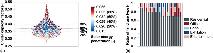
4. Results
Figure 5(a) presents the results of our energy performance assessment for the 1001
planning scenarios of various land use type allocations, by their simulated chiller
capacity factor and solar energy penetration. The scenarios in the top 20% of
solar energy penetration show a broad range of performances on chiller capacity
factor and vice versa. There are 22 planning scenarios that are in the top 20%
for both energy performance metrics. Figure 5(b) presents the ratios of land use
types for these 22 planning scenarios (vertical bars). The majority have 70%˜80%
residential use. On one hand, high residential ratios necessarily imply high solar
energy penetration, as residential use has a lower energy intensity than the other
land uses (photovoltaic electricity yield is the same for all 1001 planning scenarios,
as all scenarios feature the same built form). On the other hand, during the daytime,
the negligible (solar) energy use of mostly absent residents is supplemented by the
cooling demand of other land use types. Hence, despite solar energy penetration
favouring residential use, up to 30% of other uses leads to more optimal land use
type allocation scenarios, as these scenarios feature high chiller capacity factors,
as they reduce the number of idle hours of the district cooling plant.
Figure 5. (a) The energy performance is assessed for the 1001 planning scenarios. The chiller
capacity factor and solar energy penetration are displayed by the y-axis and the colour
gradient. 5-quantiles are observed. (b) The ratio of land use type of the 22 planning scenarios
(vertical bars) performing top 5% on both solar energy penetration and chiller capacity factor.
5. Discussion
The use case presented above will be part of a pilot demonstrator for the Cities
Knowledge Graph (CKG) project. In this demonstrator, an urban planner uses an
interface to raise the question: “In the selected mixed-use district, how do different
ratios or combinations of land use type influence district energy performance?”
After querying relevant datasets, conducting (CEA) evaluations, and reasoning,
the CKG platform would return the needed knowledge of master-planning to the
planner as represented in Figure 5 (b). Such energy-driven knowledge helps
narrow down the design space for land use type allocation.
Keeping in mind the broader framework in which the presented use case will
function, there are three main limitations and challenges of the present paper.
Firstly, on the topic of simulation accuracy, the building geometries produced
in the action of Creation are simplified as boxes, which affects the accuracy
of electricity yield simulations, due to shading effects. Ideally, in future, theLAND USE TYPE ALLOCATION INFORMED BY URBAN 687
ENERGY PERFORMANCE: A USE CASE FOR A
SEMANTIC-WEB APPROACH TO MASTER PLANNING
level of details of future 3D city models should be scalable, according to the
respective master-planning questions. Similarly, for the accuracy of the energy
demand simulation, specific occupancy data for each land use type should be
used. Secondly, considering the practicality of the simulation, we should note
the computational expense of the use case is high (CEA simulations require
high computational power). At a project level, we should consider integrating
alternative simulation software and experimental design methods, so we can adapt
accuracy and computational expenditure depending on the planning task. Thirdly,
the presented use case of course demonstrates but two aspects of an energy
performance assessment. Simulations could take into account many more criteria
that affect district-scale energy performance, as well as other domains (such as
mobility, pollution, and outdoor thermal comfort) that introduce different or even
contradicting parameters to determine land use type allocation.
Exploring how to support such complex planning interactions is a main aim
of the CKG project, linking available cross-domain multi-scale urban datasets
and respective evaluation software to support the decision-making processes of
master-planning. The presented use case is the first step in this exploration.
6. Conclusions
In this paper, we have presented a pilot use case of land use type allocations
informed by urban energy performance using a semantic-web approach. The
metrics of solar energy penetration and chiller capacity factor are used for
assessing the energy performance of photovoltaic panels and district cooling
systems. Based on the experimental settings in this work, it is advised the
residential use type should be kept 70%-80% supplemented by one or two or three
use types of office, shop, exhibition, and entertainment. Urban planners may use
the results to narrow down the search space and make decisions for the ratios of
mixed-use projects. Furthermore, this work builds towards a pilot demonstrator
of a broader research scope - the Cities Knowledge Graph (CKG). The pilot
use case demonstrated CKG’s threefold approach of relating concepts, linking
datasets from various domains involved in master-planning as wells as automation
of planning scenario generation, assessment, reasoning and visualization. CKG
seeks to automate these processes and offer cross-domain master-planning support
through a user interface to interact with urban planners. Also, CKG aims
to integrate additional datasets and software of various urban planning related
domains, beyond energy, using a semantic-web approach.
Acknowledgements
This research is supported by the National Research Foundation, Prime Minister’s
Office, Singapore, under its Campus for Research Excellence and Technological
Enterprise (CREATE) programme.
References
Urban Redevelopment Authority, U.R.A.: 2014, “URA SPACE” . Available from (accessed 5 December 2017).688 Z. SHI ET AL.
Batty, M.: 2018, Inventing Future Cities, MIT Press.
Cairns, S. and Tunas, D.: 2019, Future Cities Laboratory: Indicia 02, Lars Muller Publishers.
Eibeck, A., Chadzynski, A., Lim, M.Q., Aditya, K., Ong, L., Devanand, A., Karmakar, G.,
Mosbach, S., Lau, R., Karimi, I.A., Foo, E.Y.S. and Kraft, M.: 2020, A Parallel World
Framework for scenario analysis in knowledge graphs, Data-Centric Engineering, 1, e6.
Eibeck, A., Lim, M.Q. and Kraft, M.: 2019, J-Park Simulator: An ontology-based platform
for cross-domain scenarios in process industry, Computers & Chemical Engineering, 131,
106586.
Gomes, J., Urbano, P., Montenegro, N. and Duarte, J.: 2012, A computer-aided urban planning
tool driven by semantic web ontologies‘, 7th Iberian Conference on Information Systems
and Technologies (CISTI 2012).
Cities Knowledge Graph, C.K.G.: 2021, “no title given” . Available from (accessed 14 December 2021).
MIT Sustainable Design Lab, initials missing: 2020, “Daysim” . Available from (accessed 7 September 2020).
Menon, A., Krdzavac, N.B. and Kraft, M.: 2019, From database to knowledge graph — using
data in chemistry, Current Opinion in Chemical Engineering, 26, 33-37.
United Nations, initials missing: 2018, “World Urbanization Prospects, 2018 revision” .
Available from (accessed 4 November 2016).
Pan, M., Sikorski, J., Akroyd, J., Mosbach, S., Lau, R. and Kraft, M.: 2016, Design technologies
for eco-industrial parks: From unit operations to processes, plants and industrial networks,
Applied Energy, 175, 305-323.
von Richthofen, A.: 2018, Urban Elements: Advanced Studies in Urban Design, ETH Zurich.
von Richthofen, A., Herthogs, P., Lim, M.Q., Cairns, S. and Kraft, M.: 2021, Semantic City
Planning Support: a literature review, Unpublished manuscript, NA, NA.
Shi, Z., Fonseca, J.A. and Schlueter, A.: 2017, A review of simulation-based urban form
generation and optimization for ener-gy-driven urban design, Building and Environment,
121, 119-129.
Shi, Z., Fonseca, J.A. and Schlueter, A.: 2021a, A parametric method using vernacular urban
block typologies for investigating interactions between solar energy use and urban design,
Renewable Energy, 165, 823-841.
Shi, Z., Fonseca, J.A. and Schlueter, A.: 2021b, Floor area density and land uses for efficient
district cooling systems in high-density cities, Sustainable Cities and Society, 65, 102601.
Shi, Z., Hsieh, S., Fonseca, J.A. and Schlueter, A.: 2020, Street grids for efficient district cooling
systems in high-density cities, Sustainable Cities and Society, 60, 102224.
The CEA team, initials missing: 2021, “City Energy Analyst v3.13” . Available from (accessed 10 November 2020).
UN-Habitat, initials missing: 2012, “Energy” . Available from (accessed 8 November 2016).
Zhou, L., Zhang, C., Karimi, I.A. and Kraft, M.: 2018, An ontology framework towards
decentralized information management for eco-industrial parks, Computers & Chemical
Engineering, 118, 49-63.You can also read