Landcover classification using texture-encoded convolutional neural networks: peeking inside the black box
←
→
Page content transcription
If your browser does not render page correctly, please read the page content below
Spatial Knowledge and Information Canada, 2019, 7(6), 3

Landcover classification using texture-
encoded convolutional neural networks:
peeking inside the black box
MALIK KARIM                                      COLIN ROBERTSON
Department of Geography and Environmental        Department of Geography and Environmental
Studies, Wilfrid Laurier University              Studies, Wilfrid Laurier University
malikkarim360@gmail.com                          crobertson@wlu.ca

                                                 patterns in the landscape. This finding
ABSTRACT                                         suggests the potential generalizability of
                                                 texture-based CNNs and that classification
Pattern recognition, object detection, and       errors associated with such models might be
image classification are typical areas in        lower than that of traditional CNNs.
which contemporary computer vision
algorithms are being deployed. In high-          1. Introduction
resolution      remotely     sensed     image
classification problems, texture features can    Landcover classification is becoming
be crucial to the recognition of different       increasingly vital and more sophisticated as
landcover classes. Using a classical             remotely sensed data are now available at
convolutional neural network (CNN) and           high temporal and spatial resolutions.
texture-encoded      CNN      variant,   early   Landcover information is crucial for
concatenation CNN (EC-CNN), we explore           monitoring, and reporting on transitions in
the relevance of texture-based features in       vegetation types across time and space
landcover classification. In this paper, we      (Albert and Gonz, 2017). Remotely sensed
demonstrate the utility of using shallow         image classification represents a domain in
layers of a CNN for learning discriminative      which computer vision methods are now
local texture features in very high-resolution   widely       applied.     Landcover      type
images. We apply these models to a case          discrimination is a typical task in which
study problem involving ground lichen            machine learning algorithms are frequently
classification in a tundra ecosystem and         deployed. The recent successes of artificial
found that the texture EC-CNN out-               neural networks in object detection, pattern
performed the non-texture based classical        recognition and scene classification tasks
CNN. Given that deep learning models are         have resulted in growing interest in
often perceived as “black-boxes”, in order to    exploring the capabilities of these models
illustrate how effective texture models          (Hinton et al., 2012). While traditional
represent landcover features, we extract         landcover mapping methods focus on
feature maps from each model to provide a        spectral homogeneity of classes as the basis
visual interpretation of the texture patterns    for discrimination, there are several cases
learned by the various models. The CNN           where the spatial arrangement of features
model saliency maps contain more localized       on the landscape is a key discriminant
patterns which are not easily interpretable,     feature. Forest fragmentation, thermokarst,
visually. The EC-CNN model on the other          and vegetation patterns in arid ecosystems
hand contain patterns that are more              are all typically recognized by their texture
intuitive and representative of fine-grained     (i.e., spacing and arrangement) rather than
textures. Furthermore, almost all filters in     their     spectral    characteristics.  Most
the model detected locally significant           traditional classification techniques and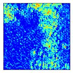
2   Landcover classification using texture-encoded convolutional neural networks

classifiers are unable to achieve high            boxes”, we adapt existing approaches to
accuracy in these settings due to high data       compare activation feature maps from the
dimensionality and scale dependencies             CNN models (Jacobs and Goldman, 2010;
(Basu et al., 2018). On recognizing this          Selvaraju et al., 2017). The contributions of
limitation, there has been increasing             this paper are therefore two-fold: (a) design
interest in approaching texture mapping           of a simple texture-encoded CNN for
using ANN techniques (Lloyd et al., 2004).        landcover classification, and (b) use of
Andrearczyk and Whelan (2016) found that          computer vision techniques to visualize and
a texture explicit CNN model out-performed        gain insight into how well the models learn
the state-of-the art models in texture            texture patterns.
datasets. In a related study, Cimpoi and
Vedaldi (2015) demonstrated CNN models            2. Experimental methods
capability to detect textural classes in scenes
characterized by diverse texture categories .
                                                  2.1 Texture-encoded CNN model design
Research in landcover classification and
                                                  CNNs consist of filter banks capable of
landscape comparison has demonstrated
                                                  extracting hierarchical spatial features using
the potential of CNNs, especially in
                                                  a weight-sharing framework (Cimpoi et al.,
determining similarities in urban land use
                                                  2015). Texture analysis and synthesis has
patterns (Albert and Gonz, 2017). Despite
                                                  been implemented in CNNs and proven to
the level of improvements achieved using
                                                  represent discriminative local features
CNNs, the fact that higher hierarchical
                                                  (Gatys et al., 2015; Ustyuzhaninov et al.,
features are often used to perform
                                                  2016). Our design of a texture-based CNN is
classifications in classical CNNs raises
                                                  motivated by previous findings that lower-
questions        pertaining      to      their
                                                  layers pool dense orderless features and
generalizability, transferability and error
                                                  capture relevant local patterns as compared
rate across domains, locations, and datasets.
                                                  to higher-layers which contain global shape
Higher-level CNN features or activations
                                                  information (Cimpoi et al., 2015). Our
lack geometric invariance, thus diminishing
                                                  approach is also inspired by Andrearczyk
their robustness and generalization power
                                                  and Whelan (2016) technique that derives
for classification and mapping across
                                                  an energy feature vector from the
variable scene configurations (Gong et al.,
                                                  penultimate pooling layer and concatenates
2014). Lower-layer feature maps however
                                                  them with the first fully connected layer.
contain significant local information that
capture texture and hence extracting and
                                                  In the context of landscape or landcover
concatenating such features could build
                                                  classification and similarity search, global
texture explicit models which are robust and
                                                  shape information present in fully
less prone to classification errors. Research
                                                  connected layers is of little relevance as
on the use of dense lower CNN features
                                                  spatial patterns often bear no uniquely
information in classification task is limited.
                                                  defined geometry across space and time.
This necessitates the specification of explicit
                                                  Our method encompasses the concatenation
texture models capable of learning and
                                                  of multi-layer features and learning a
accurately representing textured landcovers.
                                                  representation of the data generating
                                                  process concurrently. In the feature fusion
We specify a texture-encoded CNN for
                                                  framework, feature maps from three
feature extraction and classification of
                                                  hierarchical layers are concatenated; these
lichen for a landscape in a low-tundra
                                                  are subsequently flattened to feature vectors
ecosystem in Northwest Territories, Canada.
                                                  to construct the first fully connected (FC)
We further compare a classical CNN with
                                                  layer. Here, we attempt to derive a non-
that of our texture-based model. Given that
                                                  existing fully connected layer FC1 via
CNNs are to some degree, considered “black
                                                  merging features from all preceding layers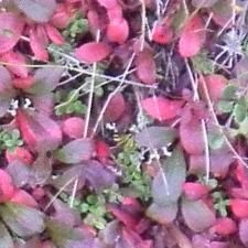
Landcover classification using texture-encoded convolutional neural networks 3
(i.e., pool1, pool2, and pool3). The classical photographs from a study site at Daring
CNN is also designed in parallel to enable Lake, Northwestern Territories, Canada are
performance comparison with the texture used in this study. Spatial resolutions of the
CNN. Figure 1 depicts the architecture of a sample imagery are 0.05 cm and 1 cm for
classical CNN and a texture-encoded CNN. the ground photos and UAV, respectively.
The architecture of both CNNs (i.e., the size To generate the training samples, high
of hidden layers) is adapted from the VGG resolution ground-truth photos from the
model (Simonyan and Zisserman, 2014), study site were tiled into 225 × 225 patches
with slight modifications in the first and of homogenous landcover categories. We
second hidden layers to learn 96 features. also generated 225 × 225 non-homogeneous
Table 1.0 provides further information tiles comprising all the three vegetation
regarding the model architecture. categories. These are reserved for probing
into CNN layers to unravel what the models
have learned. The tile dimensions used are
significant enough to contain relevant
discriminative features in the 5 × 5 receptive
field of the CNN filters (Basu et al., 2015).
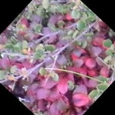
The lichen class contains 1300 samples
while the green and colored vegetation
a) categories comprise 1000 images in each
class, resulting in 3300 patches. The green
vegetation class mainly comprise sedges,
birch and alder shrubs and grasses, while
the colored vegetation category represents
primarily dwarf shrubs in the genus
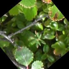
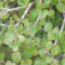
Arctostaphylos (i.e., bearberry). Figure 2.0
depicts samples of the landcover classes.
The ground photos are used exclusively for
b) model training, and classification is
implemented on 450 × 450 tiles of UAV
Figure 1.0 A classical CNN (a) and a texture-based EC-CNN imagery. The rectified linear unit (ReLU)
(c)
method is employed in the convolutional
layers and fully connected layers to effect
Table 1.0 Models depth and layer structure non-linear input transformation. All images
are standardized to zero mean and unit
variance. Image standardization is essential
cov1 cov2 cov3 FC1 FC2 to mitigating the ReLU signal saturation
and ensuring convergence of the gradient
64×5×5 96×5×5 96×5×5 128 128 descent algorithm (Nair and Hinton, 2010).
ECCNN pl2×2, pl2×2, pl2×2, ×1 ×1 In training, the stochastic gradient
str 2 str 2 str 2 algorithm with cross-entropy cost function
is used. The learning rate, momentum and
64×5×5 96×5×5 96×5×5 128 number of iterations are set to 0.01, 0.9 and
CNN pl2×2, pl2×2, pl2×2, ×1 50, respectively. In order reduce overfitting,
str 2 str 2 str 2
a 50% drop-out is applied to both
convolutional and fully connected layers.
Shutting 50% hidden units (drop-out) is an
2.2 Sample preparation and model effective regularization technique for
training minimizing potential overfitting. The
Imagery from an unmanned aerial vehicle learning rate, and momentum were held
(UAV) as well as georeferenced ground unchanged. An epoch of 50 was selected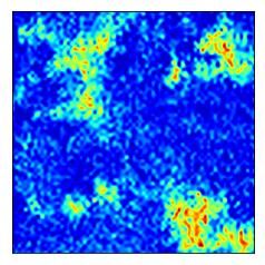
4    Landcover classification using texture-encoded convolutional neural networks

after training the models for incremental                      its losses and accuracies peaking after 40
iterations of 20, 30, 40, and 50. The models                   epochs but do not exhibit clear stability. It is
performance did not improve appreciably                        possible that the CNN requires additional
after 40 epochs, thus the selection of 50                      training time to learn. However, it should be
epochs for training both models. The                           noted that CNNs are susceptible to over
training, validation and test data comprise                    training, resulting in poor performance on
60%, 20% and 20%, respectively. The                            unseen data.
experiment is conducted with CPU
implementation using Keras + Tensorflow                           a)                              b)
in Python. Training duration is 9 hours on
i7-3930K CPU @ 3.20GHz, and 52.0GB
windows computer.

                                                               Figure 3.0 Training and validation history; classical CNN (a)
                                                               and a texture-based EC-CNN (b)

                                                               Figure 4.0(b-c) illustrates tundra vegetation
                                                               classification using the models. The maps
Figure 2.0 Samples of landcover types in the study site;       appear to be difficult to distinguish visually,
lichen (first column), green vegetation (second column), and   though close examination reveals some shift
colored vegetation (third column)                              in spatial distribution of the landcover
                                                               types, notably, the colored vegetation class.
                                                               In order to enable direct class comparison, a
3. Results and discussion                                      difference map (Figure 4.0d) between 4.0b
                                                               and 4.0c is generated. It can be noticed that
The model accuracy reports on the test                         the models show large discrepancy in
sample     are     97.50%     and    96.52%,                   classifying the color vegetation class, while
respectively, for EC-CNN and CNN models;                       agreeing closely in lichen and green
this suggests a marginal improvement in                        vegetation prediction. It appears that the
performance of the texture-based model                         observed disagreement stems from shift in
compared to the classical CNN, and                             class allocation of pixels between the green
probably accounts for the close similarity in                  and color vegetation types. This may be
the classification results outputted by the                    explained by the fact that the two categories
models. A plausible cause of this slight                       contain predominantly similar textures.
difference in test accuracy can be attributed                  Hence the models are relying on spectral
to the relatively small training sample size                   signatures to discriminate. It must be
used. With sample size of 2640 (60% of                         emphasized that ground photos were mostly
3300) used in training and validation (20%                     samples from the similar locations as the
of 3300), the traditional CNN is likely to                     UAV images. Though the imagery come in
demonstrate competitive performance.                           different spatial resolutions, training on
Figure 3.0 shows training/validation losses                    ground photos and predicting vegetation
and training/ validation accuracies for both                   classes on UAV mitigates the effects of
models. It can be observed that the EC-CNN                     potential overfitting in training data being
losses and accuracies peak and stabilize                       transferred to the classification stage. This
after 25 epochs. The CNN on other hand has                     also tests as well as exposes the potential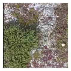
Landcover classification using texture-encoded convolutional neural networks 5
generalizability of the models on an unseen
dataset.
Our approach to probing the performance of
the models in the classification of the
various landcover categories surprisingly Original Maps EC-CNN CNN
reveals that the texture-based model
prediction of the landcover types is visually a)
intuitive and interpretive; in fact, visual
inspection shows that the model has learned
relevant feature maps about lichen
composition and configuration, and that it is
easier for users to link, for example, what
the model thinks is lichen in the original b)
map to the class activation maps extracted
from layer three (cov3) of EC-CNN model.
This implies the model predictions may be
more robust and accurate despite the
competing performance seen in the CNN. In
Figure 5.0, class activation maps (CAM)
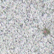
Figure 5.0. Class activation maps for Lichen. First column
extracted from lichen filters found in the shows sample UAV images, second column (EC-CCN model
models (cov3 layers) shed light on the CAM), and third column (C-CNN model CAM)
patterns learned by each model to
discriminate lichen. It can be observed that 4. Conclusion
the EC-CNN features are denser than the
CNN features which exhibit sparsity and In this paper, we demonstrate the
smoothness. robustness of texture-based CNN in a lichen
dominated tundra ecosystem classification
Original Maps EC-CNN CNN task. Using gradient-based class activation
a) b) c) maps as in (Selvaraju et al., 2017), we show
that our texture-encoded CNN can be more
effective and less error prone in
classification problems as its CAMs are
more intuitive and visually depict a
particular landcover class the model
d) predicts. Further research is essential to
Prediction agreement testing the accuracy of the texture model on
Green Vegetagtion
Color Vegetation
benchmark texture datasets. It is also worth
Lichen exploring the performance of different
architectures of the texture model. The
effectiveness of texture-based features in
change detection and landscape similarity
search is another research area worth
investigating.
Figure 4.0. Classification of UAV map (a), using EC-CNN
(b), CNN (c), and difference map (d) derived from (a) and
(b)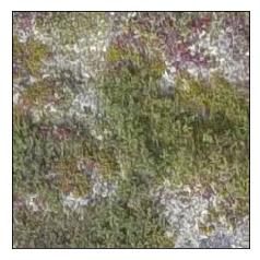
6   Landcover classification using texture-encoded convolutional neural networks

                                                       Features Yunchao. In European
                                                       Conference on Computer Vision, 392–
                                                       407.
Acknowledgements                                  Hinton, G. E., Srivastava, N., Krizhevsky, A.,
The authors acknowledge       NSERC     for            Sutskever, I., Salakhutdinov, R. R.,
supporting this research.                              Yosinski, J., Lipson, H. (2012).
                                                       Improving      neural     networks     by
References                                             preventing co-adaptation of feature
                                                       detectors, 1–18.
                                                  Jacobs, D. E., & Goldman, D. B. (2010).
Albert, A., & Gonz, M. C. (2017). Using
                                                       Cosaliency : Where People Look When
    Convolutional Networks and Satellite
    Imagery to Identify Pa erns in Urban               Comparing Images.
    Environments at a Large Scale, 1357–          Lloyd, C. D., Berberoglu, S., Curran, P. J., &
    1366.                                              Atkinson, P. M. (2004). A comparison
Andrearczyk, V., & Whelan, P. F. (2016).               of texture measures for the per-field
                                                       classification of Mediterranean land
    Using filter banks in Convolutional
    Neural       Networks     for   texture            cover. International Journal of
                                                       Remote Sensing, 25(19), 3943–3965.
    classification R. Pattern Recognition
                                                  Nair, V., & Hinton, G. E. (2010). Rectified
    Letters, 84, 63–69.
                                                       Linear Units Improve Restricted
Basu, S., Ganguly, S., Mukhopadhyay, S.,
                                                       Boltzmann Machines. Proceedings of
    DiBiano, R., Karki, M., & Nemani, R.
                                                       the 27th International Conference on
    (2015). DeepSat-A Learning framework
                                                       Machine Learning, (3), 807–814.
    for Satellite Imagery.
Basu, S., Mukhopadhyay, S., Karki, M.,            Simonyan, K., & Zisserman, A. (2014). Very
    DiBiano, R., Ganguly, S., Nemani, R., &            deep convolutional networks for large-
    Gayaka, S. (2018). Deep neural                     scale image recognition. arXiv preprint
                                                       arXiv:1409.1556.
    networks for texture classification—A
    theoretical analysis. Neural Networks,        Selvaraju, R. R., Cogswell, M., Das, A.,
                                                       Vedantam, R., Parikh, D., & Batra, D.
    97, 173–182.
Cimpoi, M., Maji, S., & Vedaldi, A. (2015).            (2017).        Grad-CAM:           Visual
                                                       Explanations from Deep Networks via
    Deep filter       banks    for  texture
                                                       Gradient-Based              Localization.
    recognition      and      segmentation.
                                                       Proceedings of the IEEE International
    Computer       Vision   and    Pattern
                                                       Conference on Computer Vision, 2017–
    Recognition (CVPR), 2015 IEEE
                                                       Octob, 618–626.
    Conference On, 3828–3836.
                                                  Ustyuzhaninov, I., Brendel, W., Gatys, L. A.,
Gatys, L. A., Ecker, A. S., & Bethge, M.
    (2015). Texture Synthesis Using                    & Bethge, M. (2016). Texture Synthesis
    Convolutional Neural Networks, 1–9.                Using Shallow Convolutional Networks
Gong, Y., Wang, L., Guo, R., & Lazebnik, S.            with Random Filters, 1–9.
    (2014). Multi-Scale Orderless Pooling
    of Deep Convolutional Activation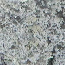
You can also read