Langlade County Outdoor Recreation Plan - Also covering the municipalities within Langlade County - ncwrpc
←
→
Page content transcription
If your browser does not render page correctly, please read the page content below
Langlade County
   Outdoor Recreation Plan
  Also covering the municipalities within Langlade County

                             2017-2021
              Effective January 1, 2017 to December 31, 2021

Prepared by: North Central Wisconsin Regional Planning Commission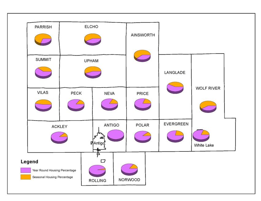
Langlade County Board of Supervisors
David J. Solin, Chairperson
Pete Pennington, Chairperson
Ronald M. Nye, Chairperson
Julie Ann Webb James R. Jansen
Robert Benishek Duff Leaver
Arlene Bonacci Holly Matucheski
Richard J. Burby Douglas Nonnenmacher
Vernon Cahak Joseph Novak III
Dale A. Dahms Larry Poltrock
Carol Feller Gottard Angela Schreiber
Samuel E. Hardin Richard Schuh
Richard H. Hurlbert Don Scupien
Langlade County Forestry and Recreation Committee
Ronald M. Nye, Chairman
Samuel E. Hardin
Duff Leaver
Joseph Novak III
Don Scupien
Principal authors of this plan
Erik Rantala, Langlade County Forestry Administrator
Fred Heider, AICP, NCWRPC Planner
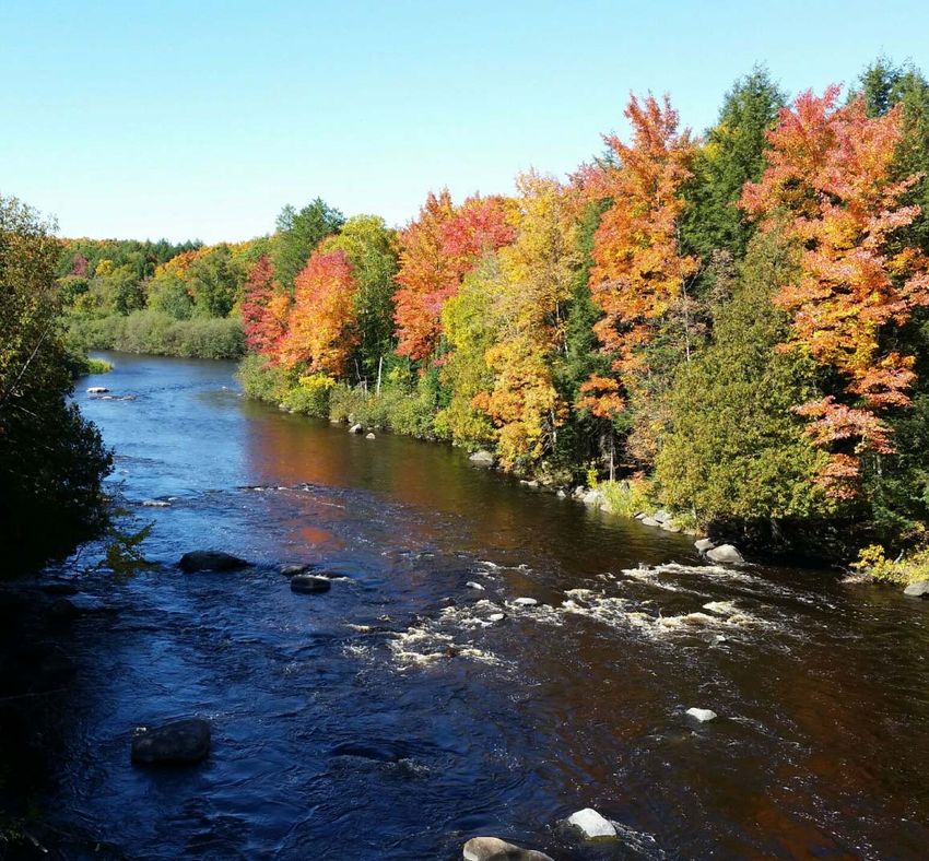
Cover Photo: Wolf River, Langland County Forestry and Recreation Department
December 2016
This plan was prepared under the direction of the Langlade County Forestry & Recreation
Committee by the North Central Wisconsin Regional Planning Commission.
For more information contact:
NORTH CENTRAL WISCONSIN REGIONAL PLANNING COMMISSION
210 MCCLELLAN STREET, SUITE 210
WAUSAU, WI 54403
Phone: 715-849-5510 www.ncwrpc.org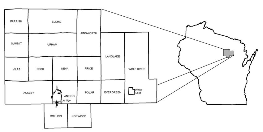
ABSTRACT

TITLE:     LANGLADE COUNTY OUTDOOR RECREATION PLAN
           2017-2021 Effective January 1, 2017 to December 31, 2021

SUBJECT:   This report assesses the existing recreation system in Langlade County, identifies
           recreation needs based upon public input and recreation standards, sets forth
           goals and objectives to be used as guidelines in formulating recreation plans, and
           establishes recommendations for improving the recreation system over the next
           five years.

           Submission of this adopted ORP to the Wisconsin Department of Natural
           Resources establishes eligibility for the county and local units of government to
           apply for a variety of Federal and State Aids. This requirement can be found in
           Chapter NR 50, Wisconsin administrative code for the following programs;
           Federal Land and Water Conservation Fund Program (LWCF), Aids for a the
           Acquisition and Development of Local Parks (ADLP), Urban Green Space
           Program (UGS) and Urban Rivers Grant Program (URGP).

           Non-profit groups, foundations, and the general public may also use this
           document to coordinate their own private efforts for developing outdoor
           recreation facilities.

DATE:      December 2016

AGENCY:    Langlade County Forestry and Recreation Department
           Fairgrounds
           1633 Neva Road
           Antigo, WI 54409

CONTACT:   Erik Rantala, Administrator
           Langlade County Forestry and Recreation Department
           715-627-6300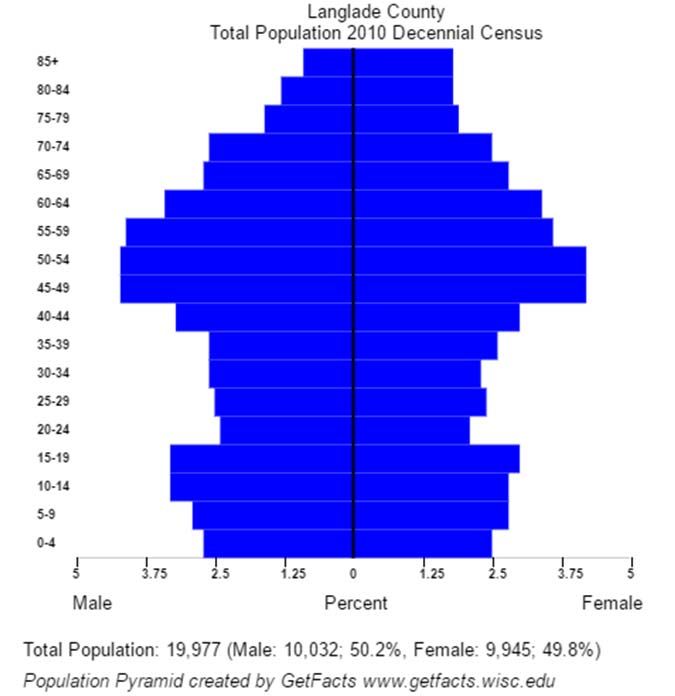
TABLE OF CONTENTS
                                                                 CHAPTERS:

1. INTRODUCTION .................................................................................................................................... 1
          - Purpose .................................................................................................................................. 1
          - Statutory Base For This Plan .............................................................................................. 1
          - Plan Components................................................................................................................. 1
          - Reference Plans .................................................................................................................... 2

2. DESCRIPTION OF LANGLADE COUNTY .................................................................................... 6
           - Physical Characteristics ....................................................................................................... 6
           - Social Characteristics ........................................................................................................... 9

3. EXISTING RECREATION FACILITIES ......................................................................................... 13
           - Introduction ........................................................................................................................ 13
           - County Forest ..................................................................................................................... 13
           - Wolf River State Trail ........................................................................................................ 13
           - Town of Peck Forests ....................................................................................................... 13
           - Points of Interest................................................................................................................ 14
           - Public Access Points to Water Bodies ............................................................................ 15
           - School District Facilities ................................................................................................... 15
           - Parks and Conservancy Areas .......................................................................................... 16
           - Forested Lands – Not State or County Owned ............................................................ 42
           - Ice Age National Scenic Trail ........................................................................................... 42
           - Private Outdoor Recreation Facilities ............................................................................. 42

4. OUTDOOR RECREATION NEEDS ASSESSMENT ................................................................... 43
         - Introduction ........................................................................................................................ 43
         - Recommendations and Projects Completed 2012-2016 .............................................. 43
         - Public Participation ............................................................................................................ 48
         - Other Plan References....................................................................................................... 57
         - Needs Driven Park Planning ............................................................................................ 57

5. GOALS AND OBJECTIVES ................................................................................................................ 58

6. RECOMMENDATIONS & CAPITAL IMPROVEMENTS .......................................................... 59
         - Countywide Recommendations ....................................................................................... 59
         - County Forest Management Unit Recommendations .................................................. 63
         - Local Government Recommendations ........................................................................... 64
         - County Capital Improvements 2017-2021 ..................................................................... 65

7. IMPLEMENTATION STRATEGIES ................................................................................................ 66

8. PROVISIONS FOR UPDATING ........................................................................................................ 71
TABLES and FIGURE: Figure 1 Location ...................................................................................................................................... 6 Table 1 Langlade County Population Projections............................................................................ 9 Figure 2 Population Pyramid..................................................................................................................... 9 Figure 3 Year Round and Seasonal Housing, 2014 ................................................................................ 10 Table 2 Langlade County Demographics ........................................................................................ 11 Table 3 Langlade County Civilian Labor Force ............................................................................. 12 Table 4 Langlade County Employment by Industry, 2014 ........................................................... 12 Table 5 Langlade County – Special Use Areas ............................................................................... 20 Table 6 Langlade County – County Facilities ................................................................................. 21 Table 7 City of Antigo – Outdoor Recreation................................................................................ 22 Table 8 City of Antigo – Outdoor Recreation................................................................................ 23 Table 9 Village of White Lake – Outdoor Recreation................................................................... 24 Table 10 Town of Ackley – Outdoor Recreation ............................................................................ 25 Table 11 Town of Ainsworth – Outdoor Recreation ...................................................................... 26 Table 12 Town of Antigo – Outdoor Recreation ............................................................................ 27 Table 13 Town of Elcho – Outdoor Recreation .............................................................................. 28 Table 14 Town of Evergreen – Outdoor Recreation ...................................................................... 29 Table 15 Town of Langlade – Outdoor Recreation ........................................................................ 30 Table 16 Town of Neva – Outdoor Recreation ............................................................................... 31 Table 17 Town of Norwood – Outdoor Recreation ....................................................................... 32 Table 18 Town of Parrish – Outdoor Recreation ............................................................................ 33 Table 19 Town of Peck – Outdoor Recreation ................................................................................ 34 Table 20 Town of Polar – Outdoor Recreation ............................................................................... 35
Table 21       Town of Price – Outdoor Recreation ............................................................................... 36

Table 22       Town of Rolling – Outdoor Recreation............................................................................ 37

Table 23       Town of Summit – Outdoor Recreation........................................................................... 38

Table 24       Town of Upham – Outdoor Recreation ........................................................................... 39

Table 25       Town of Vilas – Outdoor Recreation ................................................................................ 40

Table 26       Town of Wolf River – Outdoor Recreation ..................................................................... 41

Table 27       New Campground 5-Year Capital Improvement Plan ................................................... 65

                                                               MAPS:

Map 1          Potential Trails and Legacy Areas ........................................................................................ 5

Map 2          Outdoor Recreation ............................................................................................................. 17

Map 3          City of Antigo Outdoor Recreation ................................................................................... 18

Map 4          Village of White Lake Outdoor Recreation ...................................................................... 19

Map 5          Forest Management Units ................................................................................................... 62

                                                     ATTACHMENTS:

A.      Langlade County Wisconsin Bicycle Map
B.      Outdoor Recreation Online Survey Results
C.      Park Design and Location Criteria
D.      State and Federal Outdoor Recreation Funding Programs
Chapter 1
INTRODUCTION
PURPOSE
The primary purpose of this recreation plan is to provide continued direction toward meeting the
current and future recreation needs of the county. This is accomplished through an inventory and
analysis of outdoor recreational facilities, and the establishment of recommendations to meet
identified needs.
Adoption of this plan by the Langlade County Board and subsequent acceptance by the Wisconsin
Department of Natural Resources (WisDNR), will continue eligibility of the county and its local
units of government for the Federal Land and Water Conservation Fund Program (LWCF), Aids for
the Acquisition and Development of Local Parks (ADLP), Urban Green Space Program (UGS) and
Urban Rivers Grant Program (URGP). Adoption by all municipalities is not necessary if they wish
to cooperate with Langlade County to use this plan for grant applications. Local government grant
applications have a better chance of approval if Langlade County applies on their behalf.
Non-profit groups, foundations, and the general public may also use this document to coordinate
their own private efforts for developing outdoor recreation facilities.
STATUTORY BASE FOR THIS PLAN
This Outdoor Recreation Plan (ORP) was prepared pursuant to Wisconsin Statute §23.30 Outdoor
Recreation Program. This section serves to “promote, encourage, coordinate, and implement a
comprehensive long-range plan to acquire, maintain, and develop for public use, those areas of the
state best adapted to the development of a comprehensive system of state and local outdoor
recreation facilities and services...”
Submission of this adopted ORP to the Wisconsin Department of Natural Resources establishes
eligibility for the county and local units of government to apply for a variety of Federal and State
Aids for outdoor recreation (Chapter NR 50.06(4), Wisconsin administrative code).
PLAN COMPONENTS
This plan addresses the outdoor recreation needs for county facilities, the Village of White Lake, and
all 17 towns. The City of Antigo has its own plan, and is included for reference.
Background information on Langlade County was compiled to develop an understanding of the
environmental and social characteristics of the county and their meaning for outdoor recreation. An
inventory of existing recreational facilities exists in Chapter 3 of this plan.
The existing recreation system was analyzed to determine current and potential future deficiencies.
A combination of public survey compilation, standards analysis, and the Wisconsin Statewide
Langlade County ORP NCWRPC Page 1
2017-2021Comprehensive Outdoor Recreation Plan (SCORP) were utilized to define recreational and open space needs. Goals and objectives were created to guide the direction of recreational planning efforts within Langlade County. The recommendations are general strategies and five-year capital improvement programs for recreation facility development. A series of possible tools to aid implementation of these recommendations are set forth. This plan concludes with a note on updating to insure that it remains relevant to the needs of the county over the entire five-year span. REFERENCE PLANS Langlade County was involved in recreation planning as early as 1964, when a County Forest Plan developed by the Wisconsin Department of Natural Resources (WDNR) addressed potential recreation facilities with the county forests. In 1974, WDNR developed a plan that focused on county forests and addressed recreation needs within the local municipalities countywide. Langlade County, the City of Antigo, and the Village of White Lake directed North Central Wisconsin Regional Planning Commission (NCWRPC) to develop consecutive 5-year outdoor recreation plans starting in 1979. This 2011-2016 plan was written to continue the parks and recreation program established in the Langlade County Outdoor Recreation Plans since 1979. Plan summaries that affect outdoor recreation in Langlade County are referenced below, and Map 1 shows any referenced routes: Statewide Comprehensive Outdoor Recreation Plan (SCORP) 2011-2016 NOTE: This plan is being updated in 2016/2017. Every five years, the Wisconsin DNR publishes a SCORP as required by the Federal Land and Water Conservation Fund Act of 1965. At its core, this SCORP is used to help allocate federal funds equitably among local communities, but the document also transcends many levels of outdoor recreation discussion and policy. At the national level, this SCORP recognizes the America’s Great Outdoors (AGO) initiative, which is based on the idea that the protection of the country’s natural heritage is a nonpartisan objective shared by all Americans. The AGO encourages state and local communities to develop local conservation and recreation initiatives. This document shows a clear vision of how preserving and improving recreation opportunities in Wisconsin fits within a broader national initiative of conservation and recreation. North Central Wisconsin Regional Bicycle Facilities Network Plan NOTE: This plan is being updated in 2016/2017. This 2004 document is intended to guide the development of an interconnected bikeway system for the North Central Wisconsin Region. Potential trails are identified and an improvement description was created for each county that trails existed to facilitate how the plan can become reality in a cost efficient manner. Langlade County trails within this regional plan come from the 1999 Citizen Bike Route Initiative Plan. That plan established a network of on-road bike routes and asks WisDOT to Langlade County ORP NCWRPC Page 2 2017-2021
improve STH 64 to accommodate bicycles between Antigo and Merrill.

State Trails Network Plan
   This 2003 document clarifies a Wisconsin Department of Natural Resources (WDNR) role and
   strategy in the provision of all types of trails. The plan identifies a series of potential trail
   corridors that would link existing trails, public lands, natural features, and communities. This
   statewide network of interconnected trails would be owned and maintained by municipalities,
   private entities, and partnerships of the two. Preserving transportation corridors, such as old rail
   lines, is specifically discussed as a very important strategy in the creation of recreational and
   alternative transportation corridors. These trails are shown on Map 1.

   Segment 19—Langlade County to Michigan
   NCWRPC note: The right-of-way no longer exists, so this segment is not described.

   Segment 56—Argonne to Shawano
   NCWRPC note: This is now the Wolf River State Trail from Crandon south to White
   Lake.

   This is an active rail corridor with abandonment expected in fall of 2000 on the segment from
   Crandon to White Lake. Argonne is on the Dresser to Michigan corridor in the north, and
   Shawano links to the Mountain Bay Trail in the south of the corridor. The Crandon to
   Tomahawk corridor and the White Lake to Antigo corridor link to the Langlade County to
   Michigan corridor to form a loop. An old abandoned corridor east of White Lake in the future
   could link this corridor to the Nicolet State Trail or connect it to road routes. This corridor runs
   along the east shore of Lake Metonga at Crandon, then runs south through forested lake areas of
   the Nicolet National Forest. In Langlade County it follows the Wolf River for about seven miles
   and continues south through the Northwest portion of the Menominee Indian Reservation,
   terminating at Shawano and its connection to the Mountain Bay Trail.

   Segment 70—Antigo to White Lake
   NCWRPC note: The right-of-way no longer exists, so this segment is not described.

Langlade County Forest Comprehensive Land Use Plan
   This 2006-2020 document contains the Langlade County Forest Access Plan. A summary of
   this plan's conclusions was inserted into the public participation part of Chapter 4 – Outdoor
   Recreation Needs Assessment.

Langlade County ORP                                                                NCWRPC      Page 3
2017-2021
Wisconsin Land Legacy Report 2006-2056
   This report is a comprehensive inventory of the special places that will be critical to meet future
   conservation and outdoor recreation needs for the next fifty years. Some of the questions asked
   to guide creation of this report were: Which lands and waters remain unprotected that will be
   critical for conserving our plants and animals and their habitats? What gaps exist now (and will
   likely emerge in the future) in providing abundant and satisfying outdoor recreation? How can
   we most effectively build upon the state's existing investment in protected lands to fill
   conservation and recreation gaps? What special places will our children and grandchildren wish
   we had protected? The study focused on identifying what of our state or regionally significant
   green infrastructure remains to be protected.

   The Land Legacy report recommends protection of these lands by using federal, state, and local
   funding opportunities; along with possibly creating new kinds of incentives for landowners,
   working to draft comprehensive plans, or offering different types of technical assistance.

   Each Langlade County Legacy Area is summarized below with 5 stars representing the highest
   level for that category:

      CN Chequamegon-Nicolet                             PR Prairie River
      National Forest
      Size                                  Large        Size                               Medium
      Protection Initiated             Substantial       Protection Initiated              Moderate
      Protection Remaining               Limited         Protection Remaining             Substantial
      Conservation Significance                          Conservation Significance
      Recreation Potential                               Recreation Potential

      EC East and West Branches of the
      Eau Claire River                                   RD Red River
      Size                           Medium              Size                                 Small
      Protection Initiated          Moderate             Protection Initiated              Limited
      Protection Remaining          Moderate             Protection Remaining            Substantial
      Conservation Significance                          Conservation Significance
      Recreation Potential                               Recreation Potential

      LA Langlade Moraine                                UP Upper Wolf River
      Size                               Medium          Size                                 Large
      Protection Initiated              Moderate         Protection Initiated            Substantial
      Protection Remaining             Substantial       Protection Remaining             Moderate
      Conservation Significance                          Conservation Significance
      Recreation Potential                               Recreation Potential

Langlade County ORP                                                               NCWRPC      Page 4
2017-2021
Insert Map 1 – Potential Trails and Legacy Areas Langlade County ORP NCWRPC Page 5 2017-2021
Chapter 2
                 DESCRIPTION OF LANGLADE COUNTY

PHYSICAL CHARACTERISTICS

This section describes the physical features that make up Langlade County. This information is
essential in determining the potential as well as the limitations of an area for recreation development.
Recreation planners use this kind of data to determine which resources to develop and which
resources to protect or preserve.

Geography and Land Use

Langlade County in northeastern Wisconsin has a total of 567,621 acres; of which 55.6% is forested,
20.7% is used for agriculture, 1.6% is water, 19.2% is wetlands, 1.5% for open space, 1.0% is for
transportation (which includes airports and roads), 0.2% for residential, and 0.2% is for commercial
and industrial uses. The City of Antigo, the county seat, is in the southern part of the County. In
addition to the City of Antigo, Langlade County contains the Village of White Lake, and 17 towns
(see Figure 1).

Figure 1                Location

Langlade County ORP                                                                 NCWRPC      Page 6
2017-2021
Climate Langlade County has a continental climate characterized by cold, snowy winters, warm summer days and cool summer nights. Precipitation is well suited to outdoor activities with an annual snow fall range from 20 to 90+ inches and an annual mean of 51.9 inches during the past 40 years. June is generally the wettest month and the last part of August the driest. Precipitation averages 30.6 inches annually. The sun shines 65 percent of the time possible in summer, and 45 percent in winter. The prevailing wind is from the southwest. Average wind speed is highest in spring at 12 miles per hour. Topography The topography of Langlade County is of glacial origin, and is characterized mostly by moraines and outwash plains and partly by drumlins, eskers, kames, lake plains, bogs. The moraines include the older drift area in the southwestern part of the county. The outwash plains include the Antigo Flats, which are located in the south-central part of Langlade County. Elevations in Langlade County range from 1,070 feet above sea level where the Wolf River leaves the County, to about 1,900 feet above sea level in the Town of Langlade. Slopes are shown on Map 1. The eastern part of the county is within the drainage basin of the Wolf River, and the western part is within the Wisconsin River drainage basin. In Langlade County, the Wolf River starts at Upper Post Lake, flows generally south and east, and leaves the county just south of Markton. The Wolf River drops about 440 feet in the county, but mainly it drops between the communities of Lily and Markton. Surface Water The numerous lakes and streams in Langlade County provide outstanding recreation opportunities. The Wolf River, which flows through the eastern part of the county, is one of the most valuable rivers in the state. The source of the Wolf River is Pine Lake in Hiles, Wisconsin. The river travels the full length of the County and is the largest body of water with 984 acres. The river offers outstanding trout fishing, scenic value, canoeing, kayaking, rafting, and wildlife habitat. The gradient is very steep for a Midwestern river. It drops 420 feet in 50 miles from the Upper Post Lake Dam to the Menominee Indian Reservation. There are 17 named rapids on the Wolf River as it winds through Langlade County. In addition to the Wolf River, Langlade County has 225 streams, with a total length of 513 miles and a total surface area of about 1,800 acres. There are 387 miles regarded as prime trout fishing streams. The Wolf and Eau Claire River are two highly regarded Class 1 trout fishing resources. Lakes cover 8,864 surface acres and 381 miles of shoreline. Natural lakes number 843, with 418 of these having public access. Most of the lakes are spring lakes or seepage lakes. White Lake is the largest spring lake, while Upper Post Lake, an impoundment and a drainage lake, is the largest lake in the County. The deepest lake is Goto Lake, which is 82 feet deep. The quality of water is generally good. A number of lakes are in natural unspoiled settings. Eutrophication is a major pollution problem. During the summer, shallow water areas contain algae Langlade County ORP NCWRPC Page 7 2017-2021
and weeds. The water is predominantly very soft in the seepage, drained, and drainage lakes, but the
water is hard in many of the spring lakes and streams.

Groundwater

The groundwater in Langlade County meets municipal, industrial, rural, and irrigation needs. The
largest consumer is Antigo. The source of this water is local precipitation. The groundwater
generally moves southward. On the Antigo Flats the groundwater depth averages 25 feet deep and is
deeper in the eastern part of the flats.

The quality of the ground water is generally very good. Many soils however have very porous layers
that are poor filters for domestic waste and agricultural chemicals. The impact of development and
agriculture may cause deterioration of the ground water. Generally, the content of dissolved solids
in the ground water is relatively low in the western half of Langlade County and relatively high in the
eastern half. The higher content in the eastern part probably results from a higher content of
limestone in the glacial deposits.

Soils

Many of the soils formed entirely or partly in glacial outwash. Several soil series are common in
Langlade County and each soil textural class is described after the soil series is named as follows.
Antigo, Langlade, Minocqua, Oesterle, and Scott Lake soils formed in areas where sand and gravel
outwash is mantled with silty and loamy deposits. Pence soils formed on eskers and kames and in
other areas where sand and gravel outwash is mantled with loamy or sandy deposits. Au Gres,
Croswell, and Vilas soils formed in areas where most of the outwash is sandy.

Soil properties are important considerations when planning and developing recreation facilities. To
help evaluate soils, the U.S. Soil Conservation Service published the Langlade County Soil Survey in
1986. Updated soil suitability tables for outdoor recreation and other uses are available on the
Internet.

Soil surveys contain an abundance of information on appropriate site planning in respect to soil
suitability and developmental properties by soil type. The soil types identified are to be evaluated
for a wide range of recreational uses including the following:

        - wetland refuges for waterfowl                - ski areas
        - wildlife management                          - golf courses
        - open space or nature study areas             - campsites, hiking trails, and picnic areas
        - parks                                        - woodlands
        - athletic fields                              - hunting preserves
        - trails of all types                          - manmade ponds

Langlade County ORP                                                                 NCWRPC       Page 8
2017-2021
SOCIAL CHARACTERISTICS Population & Housing The population is projected to increase, then decrease between 2015 and 2040, resulting in a slight population decline, see Table 1. Table 1 - Langlade County Population Projections Year 2015 2020 2025 2030 2035 2040 Population 19,765 19,915 20,210 20,340 20,140 19,470 Source: WI DOA, 2013 Figure 2 illustrates the county’s predominantly older population, which is comprised primarily of persons aged 45 and older. Median age in the County increased from 40.5 years old in 2000 to 46.7 years old in 2014. The population is almost equally balanced male and female until about 75 years and older when females outnumber males, as is expected due to females’ naturally longer life expectancy. Figure 2 Population Pyramid From 2000 to 2014, the population of persons under age 18 declined from 24.4% to 15.6% of Langlade County’s population. Langlade County ORP NCWRPC Page 9 2017-2021
The total number of housing units increased from 11,187 units in 2000 to 12,363 units in 2014.
Seasonal housing units are a significant part of the housing stock, making up 24.5% of all housing
units; greater than the 6.1% of units for the state. Seasonal housing units are found in all but one of
the towns in the County, with the Town of Antigo being the exception. The percentage of seasonal
units by town ranges from 3.0% in the Town of Rolling to 68.9% in the Town of Parrish.

Figure 3 shows the percentage of seasonal housing units to total housing units in each of the towns
and municipalities in Langlade County. The trend over the last 20 years has been for seasonal home
owners to retire to their seasonal home, thus becoming permanent residents in their former
“cottages”. New permanent and seasonal homes are being built as well. These trends are both
projected to continue.

Figure 3: Year Round and Seasonal Housing, 2014

Demographic Trends

Table 2 shows a comparison within Langlade County of demographic indicators from the 2000
Census and the 2014 American Community Survey 5-year estimates. Not only has the total
population declined by over 100 persons, but the percentage of persons under 5 and under 18 have
also both declined. The percentage of persons over 65 years has increased and the median age has
increased as well.

Langlade County ORP                                                               NCWRPC      Page 10
2017-2021
Racial diversity within the County has     Table 2 - Langlade County Demographics
increased slightly, with the percentage                                              2000      2014
of White, Non-Hispanic persons             Population                               20,740     19,706
decreasing from 97.9% to 95.7%, and                                                  5.4%       5.0%
                                           Persons under 5 years
the percentages of persons identifying
                                           Person under 18 years                     24.4%     15.6%
as Black, American Indian, Asian, or
                                           Persons 65 years and over                 18.8%     20.9%
Hispanic all increasing.
                                           Median Age                                 40.5      46.7
Educational attainment has increased       Female Persons                            50.4%     49.6%
in the County since 2000. The              White Persons (not Hispanic)              97.9%     95.7%
percentage of persons with a high          Black Persons                             0.1%       0.6%
school degree or higher increased          American Indian Persons                   0.5%       0.8%
from 80.9% to 88.1%, and those with        Asian Persons                             0.3%       0.4%
a Bachelor’s degree or higher              Hispanic or Latino Persons                0.8%       1.9%
increased from 11.7% to 13.5%.                                                       80.9%     88.1%
                                           High School Graduates or Higher*
These trends are increasing, however
                                           Bachelor's degree or Higher*              11.7%     13.5%
Langlade County still has lower
educational attainment than the State      Housing Units                            11,187     12,363
which has rates of 91.4% for high          Average Household Size                     2.42      2.22
school or higher and 28.4% for a           Median Household Income                  $33,168   $40,994
Bachelor’s degree or higher.               Source: U.S. Census
                                           *Percentage of persons age 25 and over
The Office of Economic Advisors
(OEA) within the Wisconsin Department of Workforce Development creates countywide
workforce profiles that include some demographic data. The 2015 profile provided the following
population perspective:
     “From the 2010 Census to early 2015, Langlade County’s estimated population
     decreased by seventy residents. This population decrease contrasts with the growth in
     Wisconsin. Natural population change measures the difference between births and
     deaths in an area. Whereas Wisconsin experienced a 1.9 percent increase from natural
     population change, Langlade County experienced a 0.5 percent decrease. Natural
     population change is particularly sensitive to age. The decrease in Langlade County
     reflects its older population.”

     “Over 85 percent of the population lives within Langlade County’s ten most populous
     municipalities, with 40 percent living in the City of Antigo. The City of Antigo is
     estimated to have the largest population change over the first half of the decade with a
     decrease of 114 residents, or 1.4 percent. Wolf River is estimated to have the greatest
     increase with a gain of twenty-three residents, a 3.1 percent increase. Overall, population
     change was small.”

Langlade County ORP                                                                 NCWRPC     Page 11
2017-2021
Employment
Overall, the labor force has decreased from 10,298 in 2000 to 9,694 in 2014, a decrease of 5.8%, see
Table 3. The labor force is defined as the number of persons, sixteen and over, employed or looking
for employment. Persons over sixteen who are students, homemakers, retired, institutionalized, or
unable/unwilling to seek employment are not considered part of the labor force. The
unemployment rate in Langlade County more than doubled from 3.6% in 2000 to 7.7% in 2014.
Table 3 - Langlade County Civilian Labor Force
2000 2014
Labor Force 10,298 9,694
Employed 9,703 8,948
Unemployment Rate 3.6% 7.7%
Participation Rate 62.8% 59.8%
Source: U.S. Census
Table 4 contains industry level employment data for 2014 along with annual employment change.
Approximately 66 percent of total employment was in the top three industry sectors the Trade,
Transportation, Utilities sector; the Education & Health sector; and the Manufacturing sector.
Table 4 - Langlade County Employment by Industry, 2014
Avg Emp 1 Yr Change
Natural Resources 437 -6
Construction 191 5
Manufacturing 1,423 -61
Trade, Transportation, Utilities 1,943 53
Information 64 -2
Financial Activities 309 27
Professional & Business Services 237 15
Education & Health 1,484 -26
Leisure & Hospitality 652 -98
Other Services 192 1
Public Administration 422 14
Source: WI DWD, QCEW 2014
Langlade County ORP NCWRPC Page 12
2017-2021Chapter 3
EXISTING RECREATION FACILITIES
INTRODUCTION
This section is an inventory of the existing outdoor recreational facilities in Langlade County, which
will focus primarily upon public facilities. Some private facilities will be listed for reference
purposes. The private sector provides many recreational opportunities but this plan’s purpose is to
identify public facility improvements that may qualify for state and federal money.
COUNTY FOREST
The Langlade County Forestry and Recreation Department manages 130,002 acres of county forest.
This land is managed for multiple uses, and is independently certified as sustainably managed and
harvested. Some of the county forest is closed to motorized vehicles. Examples of permitted
recreational activities are hunting, fishing, hiking, snowmobiling, camping, bough cutting (permit
required), firewood collection (permit required), and wildlife observation. Refer to Maps 2 and 5 for
Langlade County Forest Land. An itemized list of county facilities exists in Tables 5 and 6.
WOLF RIVER STATE TRAIL
The Wolf River State Trail in Langlade County was developed over the last 5 years. The entire trail
is open to snowmobile use when the trails are officially open. The trail from White Lake to 1/4 mile
north of Highway 64, was developed and is open to ATV’s and UTV’s. ATV/UTV use then
branches off of the rail grade to the northwest to connect with the existing county ATV trail system.
The section from Hwy 55 at Lily north to the Forest County line was developed in 2012 and is open
to ATV/UTV use. This section connects to the Forest County ATV trail system. The section from
Lily south to ¼ mile north of Highway 64 was developed in 2014 as a non-motorized segment
during the spring, summer, and fall months. Hiking, biking and horseback riding are permitted on
this section of trail. No motorized uses (except snowmobiles) will be allowed on the section from
Highway 64 to Lily. See Map 2 to view these usage zones on the trail.
TOWN OF PECK FORESTS
The Town of Peck owns 2,333 acres of land for the Peck Town Forest, and 80 acres for Peck
School's Forest.
Langlade County ORP NCWRPC Page 13
2017-2021POINTS OF INTEREST Langlade County contains both historic and contemporary points of interest of cultural, aesthetic, recreational, and scientific importance. A number of private sites may be open to the public, while others in private ownership are closed. A) Historical Marker A state historical marker titled: Langlade County Forest-Wisconsin's First County Forest is located in Veterans Memorial County Park. A state historical marker titled: De Langlade is located at the junctions of STH 55 and 64. A state historical marker titled: Old Military Road is located 3.5 mi north of Lily at Wolf River on STH 55. A state historical marker titled: Antigo Silt Loam, State Soil of Wisconsin is located on STH 52 near the junction with STH 64. B) Geologic Sites Langlade County's topography is described in Chapter 2 – Description of Langlade County. Several land features are named below: Ninemile Hill, Town of Wolf River (T32N R14E), privately owned. C) Named Springs Langlade County's hydrology is described in Chapter 2 – Description of Langlade County. Several springs are named below: Payne Spring, Town of Parrish, county forest land. Bellis Spring, Town of Elcho, privately owned. Flood Spring, Town of Elcho, privately owned. Rasmussen Spring, Town of Upham, privately owned. Blue Springs, Town of Upham, privately owned. Woodchuck Springs, Town of Elcho, county forest land. Steven Springs, Town of Ainsworth, county forest land. Augustyn Springs, Town of Ainsworth, privately owned. Lily Springs, Town of Langlade, privately owned. O'Brien Springs, Town of Wolf River, privately owned. McCaslin Springs, Town of Wolf River, national forest. Roix Springs, Town of Wolf River, privately owned. Langlade County ORP NCWRPC Page 14 2017-2021
Galyan Springs, Town of Evergreen, privately owned.
Stillhouse Springs, Town of Evergreen, privately owned.
The Town of Evergreen has many un-named springs that are privately owned.
PUBLIC ACCESS POINTS TO WATER BODIES
Public Access sites on Langlade County's lakes and streams have been extensively inventoried and
catalogued by the North Central Wisconsin Regional Planning Commission in the Langlade County
Public Access Study 2006. This public access study is undergoing final reviews, and will soon be
available from the Langlade County Forestry Department. Various public entities in Langlade
County own and maintain 90 access points in all – 18 developed, 65 undeveloped, and 7 parks with
possible beaches. Public access to waterbodies will be ensured when development occurs by state
statute and county zoning ordinances. See the Implementation Strategies chapter under Public
Access to Waterways, Park Dedication, and Use of Easements for more details.
SCHOOL DISTRICT FACILITIES
Three school districts provide additional local recreation opportunities in Langlade County. School
yards often have playgrounds with play equipment, ball diamonds, and basketball hoops. These
school yards are neighborhood parks that range in size from 1 to 15 acres. All school district
facilities are listed along with other outdoor facilities in the tables starting on page 20.
The Unified School District of Antigo has 9 such facilities, Elcho contains 1 site, and White Lake
maintains 1 site. Each school district has school forests. These forests are open to the public for a
variety of recreational and educational uses.
The Unified School District of Antigo owns and maintains several school forests that are listed
below. Contact the Unified School District of Antigo for rules of use on school forest lands.
Pleasant View School Forest, 20 acres;
Crestwood School Forest, 38 acres;
Forestview School Forest, 38 acres;
Liberty Bell Forty, 40 acres;
Deerbrook School Forest, 80 acres;
Noboken School Forest, 168 acres;
The Elcho School District owns and maintains two school forests listed below. Contact the Elcho
School District for rules of use on school forest lands.
Elcho School Forest, 31 acres;
Summit Lake School Forest, 78 acres;
School Park Forest is a 6 acre forest owned and maintained by the White Lake School District.
Contact them for rules of use on school forest lands.
Langlade County ORP NCWRPC Page 15
2017-2021PARKS and CONSERVANCY AREAS A summary of all the local and county parks, school grounds, state parks, and conservation areas with the amenities at each are located in the following tables and maps. The following brief descriptions of each park type are from SCORP 2005-2010. Elementary school playgrounds may be categorized as mini parks if only a playground exists. High schools grounds that contain several types of recreation fields would be listed under community parks. School forests are listed as community parks. Linear Parks are trails that may have various lengths. Mini Parks – Generally less than 5 acres, these parks are special areas that serve a concentrated or limited population or specific group such as tots or senior citizens. One prominent feature or recreation facility like a playground may be present as the purpose of this park. The service area for this park generally is a ½ mile radius, and a population of 2,000-3,000 people. Neighborhood Parks – An area of 5 to 25 acres that serves as the recreational and social focus of the neighborhood. Active and passive recreational activities in this park include field, court, and ball games; skating; crafts; and picnicking. Facilities may also include a playground, wading pool, ball field, multi-activity field, ball diamond, tennis courts, skatepark, and shelter. Trees, open fields, and undeveloped natural areas are also desirable components of neighborhood parks. The service area for this park generally is a 1 mile radius, and a population of 2,000-5,000 people. Community Parks – Usually more than 25 acres in size, these parks serve entire communities, and are located adjacent to a collector street to provide community-wide vehicular access. The purposes of this park are to meet the recreational needs of several neighborhoods, as well as to preserve unique landscapes and open spaces. These parks allow for group activities not feasible at the neighborhood level. All of the facilities of a neighborhood park may exist, along with nature trails and scenic areas. Special Use Areas – These areas are for single purpose recreational activities, and often are designed as revenue generating enterprises such as for baseball, golf, nature centers, arboreta, formal gardens, gun ranges, festivals, ski areas, or areas that preserve and maintain cultural or archeological sites. County Parks – County parks consist of 100 acres or more that are specifically set aside for active and passive recreation uses to accommodate large gatherings, special events, and individual users. These parks have scenic natural features that preserve the character of the region and provide a wide variety of compatible outdoor recreation activities; and may also provide areas for camping, historic preservation, protection of natural areas, and special use areas. State Parks – State parks are similar to county parks, with two differences: they consist of several hundred acres and preserve natural areas of statewide importance. Conservancy Areas – Conservancy areas are managed for the flora & fauna resources that exist at a site. Activities like hiking, wildlife watching, hunting, and fishing may be allowed on these lands that may have labels like state natural areas, forests, or wildlife refuges. Each conservancy area has specific rules of use for public enjoyment. Langlade County ORP NCWRPC Page 16 2017-2021
Insert:
Map 2 – Outdoor Recreation

Langlade County ORP          NCWRPC   Page 17
2017-2021
Insert:
Map 3 – City of Antigo Outdoor Recreation

Langlade County ORP                         NCWRPC   Page 18
2017-2021
Insert:
Map 4 – Village of White Lake Outdoor Recreation

Langlade County ORP                                NCWRPC   Page 19
2017-2021
Insert Table 5:
Langlade County – Special Use Areas

Langlade County ORP                   NCWRPC   Page 20
2017-2021
Insert Table 6:
Langlade County – County Facilities

Langlade County ORP                   NCWRPC   Page 21
2017-2021
Insert Table 7:
City of Antigo – Outdoor Recreation

Langlade County ORP                   NCWRPC   Page 22
2017-2021
Insert Table 8:
City of Antigo – Outdoor Recreation

Langlade County ORP                   NCWRPC   Page 23
2017-2021
Insert Table 9:
Village of White Lake – Outdoor Recreation

Langlade County ORP                          NCWRPC   Page 24
2017-2021
Insert Table 10:
Town of Ackley – Outdoor Recreation

Langlade County ORP                   NCWRPC   Page 25
2017-2021
Insert Table 11:
Town of Ainsworth – Outdoor Recreation

Langlade County ORP                      NCWRPC   Page 26
2017-2021
Insert Table 12:
Town of Antigo – Outdoor Recreation

Langlade County ORP                   NCWRPC   Page 27
2017-2021
Insert Table 13:
Town of Elcho – Outdoor Recreation

Langlade County ORP                  NCWRPC   Page 28
2017-2021
Insert Table 14:
Town of Evergreen – Outdoor Recreation

Langlade County ORP                      NCWRPC   Page 29
2017-2021
Insert Table 15:
Town of Langlade – Outdoor Recreation

Langlade County ORP                     NCWRPC   Page 30
2017-2021
Insert Table 16:
Town of Neva – Outdoor Recreation

Langlade County ORP                 NCWRPC   Page 31
2017-2021
Insert Table 17:
Town of Norwood – Outdoor Recreation

Langlade County ORP                    NCWRPC   Page 32
2017-2021
Insert Table 18:
Town of Parrish – Outdoor Recreation

Langlade County ORP                    NCWRPC   Page 33
2017-2021
Insert Table 19:
Town of Peck – Outdoor Recreation

Langlade County ORP                 NCWRPC   Page 34
2017-2021
Insert Table 20:
Town of Polar – Outdoor Recreation

Langlade County ORP                  NCWRPC   Page 35
2017-2021
Insert Table 21:
Town of Price – Outdoor Recreation

Langlade County ORP                  NCWRPC   Page 36
2017-2021
Insert Table 22:
Town of Rolling – Outdoor Recreation

Langlade County ORP                    NCWRPC   Page 37
2017-2021
Insert Table 23:
Town of Summit – Outdoor Recreation

Langlade County ORP                   NCWRPC   Page 38
2017-2021
Insert Table 24:
Town of Upham – Outdoor Recreation

Langlade County ORP                  NCWRPC   Page 39
2017-2021
Insert Table 25:
Town of Vilas – Outdoor Recreation

Langlade County ORP                  NCWRPC   Page 40
2017-2021
Insert Table 26:
Town of Wolf River – Outdoor Recreation

Langlade County ORP                       NCWRPC   Page 41
2017-2021
FORESTED LANDS – NOT STATE or COUNTY OWNED

Forested lands that may be open to the public but are not part of the county forest are privately held
lands by individuals and corporations that are enrolled in either the Forest Crop Law or the
Managed Forest Law. Currently, lands can only be newly enrolled in Managed Forest Law.

As of January 1, 2016 there are 3,811 acres under the Forest Crop Law (FCL), which are open to the
public to hunt and fish.

As of January 1, 2016, there are 419,845 acres enrolled in the Managed Forest Law (MFL) program.
Of that MFL acreage, there are 52,033 acres designated open to the public for hunting (not
trapping), fishing, hiking, sightseeing, and cross-country skiing only (s. 77.83(2)(a), Wis. Stats.).

Other than the following exception, MFL lands enrolled as open must not be posted as to restrict
access. All MFL program participants can restrict access without penalty to the landowner to areas
that are within 300 feet of any building or harvesting operation. Landowners may prohibit any
activity associated with public use of open MFL land which may cause property damage (e.g. cutting
trees, brush, building permanent blinds or tree stands, putting nails in trees). Temporary tree stands
and bait stations (where hunting regulations allow) are an accepted and allowable method of hunting
conditional upon no damage to the property, including the tree. Access by motor vehicles or
snowmobiles may be prohibited by the landowner on open as well as closed lands. Open MFL
lands can be found on the DNR website at http://dnrmaps.wi.gov/opfl/. It is the responsibility of
the user to know where they are and which land is open to the public.

ICE AGE NATIONAL SCENIC TRAIL

The Ice Age National Scenic Trail was authorized as a National Scenic Trail by Congress in 1980
and as a State Scenic Trail in 1987. The route generally follows the nationally significant glacial
features of Wisconsin and is intended to provide opportunities for low impact, non-motorized
recreational use. The trail has existed in Langlade County since 1975 with more than 50 miles already
on the ground between the Lincoln County line north of Highway 17 to the community of Polar.
Much of this existing trail passes through the Langlade County Forest. A planning process is
currently underway to determine a route for the trail southwest of Polar and to provide a connection
to the trail in Marathon County.

PRIVATE OUTDOOR RECREATION FACILITIES

Private Campgrounds
There are 13 private campgrounds totaling over 500 campsites in Langlade County. All of these
campgrounds are available for a fee to the public.

Private Golf Courses
There is 1 private 18-hole golf course and 2 private 9-hole golf courses that are open to the public
for greens fees. Two driving ranges also exist.

Langlade County ORP                                                              NCWRPC      Page 42
2017-2021
Chapter 4
OUTDOOR RECREATION NEEDS ASSESSMENT
INTRODUCTION
This chapter starts with a list of projects that were completed over the last five years to recognize
what has occurred within the county.
Recreational needs within the county were identified primarily by: 1) gathering public input; and 2)
through Langlade County Forestry staff & NCWRPC staff assessments.
RECOMMENDATIONS AND PROJECTS COMPLETED FROM 2012-2016
Langlade County
Camp Susan – Expansion of facility (additional shelter space, areas for program activities).
Road to camp was improved and maintained.
Improved road into parking area at Kettlebowl Ski Hill and Cross Country Ski Trail.
Constructed restroom facility at Moose Lake boat launch.
Completed shoreline restoration at Moose Lake boat launch.
Developed nature trail at Moose Lake park in partnership with the Friends of Moose Lake.
Developed non motorized section of Wolf River State Trail from Lily south to ¼ mile north of
Highway 64.
Developed trailhead at Lily for the Wolf River State Trail.
Parking lots at Wallrich Road and White Lake were developed for ATV trailhead.
Ten gates were installed on the Wolf River State Trail.
Local ATV clubs sold ads so a new ATV map could be printed and distributed.
Approved UTV use on funded ATV trail system.
Improved and added mileage to the Jack Lake cross country ski trail.
Purchased equipment to assist with Jack Lake ski trail grooming and maintenance.
Constructed ski chalet at Jack Lake ski trail with donated funds from the Spychalla family.
Constructed pit toilet at Jack Lake cross country ski trail.
Further developed snowshoe trail at Jack Lake.
Constructed restrooms in campground at Veterans Memorial Park.
Constructed a three-season shelter and restrooms at Veterans Memorial Park.
Constructed three camping cabins at Veterans Memorial Park in cooperation with the Elcho
School District.
Langlade County ORP NCWRPC Page 43
2017-2021 Continued Development of 18-hole disc golf course at Veteran’s Memorial Park.
Updated electric service to shelters at Veteran’s Memorial Park.
Approved Ice Age Trail land use agreement as a perpetual agreement.
Extended several Special Use Agreements with a variety of Recreational Clubs in Langlade
County.
Assisted Triple R Horseback Riding Club in further development of trailhead including the
construction of high lines and a pit toilet in Elton.
Assisted Langlade County Sled Dog Club in development of additional trails on Hwy 52 in the
Town of Langlade.
Repaired the 100-yard rifle range and the retaining wall at the Langlade County Bow and Gun
Range.
Developed a short range for handgun use at the Langlade County Bow and Gun Range.
Recovered lead shot from the Trap Range at the Langlade County Bow and Gun Range.
Parking area and storage building were rehabilitated at the Langlade County Bow and Gun
Range.
Cooperation with Knights Templar Club to maintain the access that crosses their property.
City of Antigo
General Improvements
Created a shared community calendar and searchable organization and group database
through collaboration with various community resource groups including: UW Extension,
Antigo Public Library, Economic Development, Antigo/Langlade County Chamber of
Commerce, Boys & Girls Club of Langlade County, Family Corner Resource Center, and
more.
Created a community resource website: www.alcinfo.com through collaborative efforts with
Antigo/Langlade County County Chamber of Commerce, Economic Development,
Emergency Management, and Langlade County (2015).
Placed PBIS Signage at all ball parks and athletic fields (funding provided by Antigo Area
Optimist Club).
Shelter lighting was updated to improve energy efficiency, and all shelters are now on dusk-
to-dawn timers.
Permanent equipment boxes were placed for T-ball, soccer and flag football (2016).
New bleachers were placed at various ball fields and athletic fields to meet code compliance.
Created a memorial donation policy, which includes benches and other park and recreation
items.
All ball fields have infield top dress material.
Pickleball League was created.
Langlade County ORP NCWRPC Page 44
2017-2021City Wide Bike Route
Placed signage donated by individuals, businesses, organizations, and groups. Antigo Area
Optimists donated the posts for the signs.
Installed pedestrian signal crossing lights at 7th Avenue and Highway 45 (donated by the
hospital). This crossing is a designated intersection crossing for the City Wide Bike Route,
and connects to the Springbrook Trail (2016)
Springbrook Trail
Constructed over 200’ of boardwalk and bridge just west of the high-line (2015)
Contracted trenching along Springbrook Trail in designated areas to prevent break-up of
blacktop from roots (started in 2014; continued annually or semi-annually)
Repaired approximately 200’ of blacktop along Springbrook Trail between Hudson Street
and 2nd Avenue (2014)
Built a bridge (with Inland Lake and Rotary Funds) across Spring Brook off of Byrne Road
(2014)
Placed Water Fountain/Service off Dead-End of Virginia Street (this creates compliancy for
Campground Permit when Buckskinners hold their event) (2014).
Built a second bridge (with Inland Lake and Rotary Funds) across Spring Brook and just
west of the high transmission electrical lines (2015)
Repaired approximately 150’ of blacktop along Springbrook Trail between Hudson (heading
east) and the Northern Natural Area.
Single Track Mountain Bike Trail
Placed signage (2014)
Moved fence back and created parking area (2014)
Coordinated with Antigo Area Bike and Ski Club members and constructed a single track
bike loop at the old landfill off of Dump Road (2014)
Al Remington Ball Field (formerly known as Little League Park)
Groundbreaking occurred for a new Al Remington Little League Press Box, Concession, and
Equipment Room in the spring of 2012. This project is partially funded through a donation
from the Antigo Optimist Club and other community groups and individuals.
Patio was completed around the Al Remington/Little League Concession building (2016).
Antigo Dugout Club installed lights and batting cages at Al Remington Ball Field (funded
through donations)
Yellow fence topper was placed on outfield fence (purchased by Antigo Dugout Club)
Antigo Lake Park
Installed new roof on Lake Park Concession Building (2014)
Langlade County ORP NCWRPC Page 45
2017-2021You can also read