Langley Air Force Base: Vulnerable to Sea Level Rise
←
→
Page content transcription
If your browser does not render page correctly, please read the page content below
Langley Air Force Base: Vulnerable to Sea Level Rise Langley Air Force Base: Geography and Climate Langley Air Force Base (Langley AFB; Langley ABF Site), recently merged administratively with Fort Eustis to form Joint Base Langley-Eustis, is located at the southern end of Chesapeake Bay on its western shore in the Tidewater (Coastal Plain) region of Virginia (see map) at latitude 3704’ N, longitude 7621’ W. Lying between the Northwest and Southwest Branches (the “neck”) of the Back River estuary (see map) at the lower end of the Virginia (York-James) Peninsula, Langley faces the Chesapeake Bay near its opening to the Atlantic Ocean (see map and map ). Langley AFB and the Back River estuary are partially buffered from wave action in the Chesapeake by Factory or Northend Point, a small low (3 feet elevation, USGS GNIS) island or cape at the mouth of the Back River (see map). The climate of region surrounding Langley AFB is classified as Humid Subtropical in the Koppen or Koppen-Geiger classification system. However, the proximity of the Chesapeake and the Atlantic is responsible for a characteristic Tidewater climate that is warmer and more humid than inland areas of higher elevation. The maritime influence is also responsible for a less seasonal climate primarily as a consequence of warmer winter temperatures. Average January temperatures in the Tidewater are 35- 48 °F with average July temperatures of 71-85 °F (Virginia climate). Average annual precipitation in the Tidewater is 41.32 inches, with average January and July precipitation of 2.81 and 4.65 inches, respectively Virginia Climate. Long-term local means for the Langley-Hampton, VA area are similar to those for the Tidewater Region, with slightly wetter summers (monthly average climate, Hampton VA). Regional Climate Change All of North America is very likely to warm during the 21st Century, and annual mean precipitation is likely to increase in the northeast USA (IPCC AR4 WGI, Chapter 11: Christensen et al. 2007). In general terms, this projection of a warmer and wetter Northeast, also holds for the Mid-Atlantic and Langley AFB. Regional climate projections remain highly uncertain, but across models and scenarios of future energy use, the 2007 IPCC AR4 projected an increase in annual temperature for eastern North America, including the Tidewater of Virginia and Langley AFB, of from 5.0-7.7 °F (2.8-4.3 °C) by 2100. This range, and those which follow immediately below, represent the spread from the first quartile to the third quartile of the AR4 CMIP3 multi-model ensemble; 25% of the models reported values below this range, 25% above this range. The median increase in annual temperature was 6.5 °F (3.6 °C) with extremes of as little as 4.1 °F (2.3 °C) to as much as 10.1 °F (5.6 °C). For perspective, this increase would make annual temperatures at Langley AFB more comparable to those of current day Wilmington, NC or Myrtle Beach, SC. Much of the warming is projected for the winter months, with increases for the three month period of December, January and February of 5.6-8.3 °F (3.1-4.6 °C) (with a median of 8.3 °F [3.8 °C], but as high as 10.8 °F [6.0 °C]) and 4.7-7.7 °F (2.6-4.3 °C) (median 3.8 °F [2.1 °C], maximum 9.6 °F [5.4 °C]) for the
summer period of June, July August (IPCC AR4 WGI, Chapter 11: Christensen et al. 2007). Winter
precipitation is projected to increase from 9-11% (median 11%, minimum 2%, maximum 28%), while
summer precipitation remains relatively unchanged and may decrease slightly. These patterns of
projected change for the Chesapeake Bay region are in agreement with those found by Najjar et al.
(2009) analyzing an earlier 2001 IPCC Third Assessment Report (IPCC TAR ) set of model simulations.

The projected changes in temperature and precipitation are expected to impact Langley AFB and the
surrounding region in a variety of ways (Glick et al. 2007, Pyke et al. 2008 ). Many of these impacts are
associated with the ecosystems of the Chesapeake Bay (e.g., fish and wildlife habitat), but others are
more directly implicated in the operation of the base itself. For example, heat waves are likely to
increase in the region, perhaps by as much as two standard deviations (Meehl et al. 2007, p. 17 Pyke et
al. 2008) , although the maritime influence on Langley AFB and the Atlantic Coast in general might
moderate that increase slightly (see QDR Climate Change Support NORTHCOM Heatwaves). On the
other hand, the characteristic humidity of the Tidewater region could exacerbate heat waves. The
projected winter warming might reduce heating demands for the base. Conversely, summer warming
could increase cooling demands. While not directly germane to base operations, winter warming could
also increase the growing season of the Virginia Tidewater region around Langley AFB, already the
longest in the state (Tidewater climate).

The projected general increase in precipitation could bring increased flow in the rivers of the
Chesapeake Bay watershed. Hayoe et al. (2007) reported increases in annual stream flow of 9–18% in
the Pennsylvania/New Jersey portions of the watershed from an analysis of climate change for A1FI and
B1 emissions scenarios (see Pyke et al. 2008) Increased stream flow could lead to increased flood-level
high water in the rivers, bays, and marshes surrounding Langley AFB, with the concomitant increased
risk for flooding of low-lying areas or facilities near these waters. However, studies of change in stream
flow in response to climate change for the region are highly variable and some actually report declines in
stream flow, likely a consequence of higher temperatures and evaporation (see Pyke et al. 2008).
Illustrating the uncertainty in projections of precipitation and hydrology, the difference between
precipitation and evaporation projected by the Community Climate System Model Version 3 (CCSM3)
indicates a tendency towards wetter conditions in the Mid-Atlantic region, and potentially then higher
stream flow and increased risk of flooding (see precip–evap QDR Climate Change Support NORTHCOM).
Analysis of the SPI index also indicates an increase in wet conditions for the region surrounding Langley
AFB (see SPI results, QDR Climate Change Support NORTHCOM Precipitation Extremes). Flooding during
precipitation events might also increase with increased precipitation, but according to analyses of
extreme precipitation events in projections from the CCSM3 using the PEVI index, precipitation
extremes in the lower Chesapeake Bay region may show little change or actually decline slightly, except
in the latter half of the century under the A1FI scenario (see PEVI results, QDR Climate Change Support
NORTHCOM Precipitation Extremes). In any case, given its coastal geography and a mean elevation of
only 3 feet (USGS GNIS), the greater risk of flooding for Langley AFB likely rests not with precipitation
events themselves but with a projected rise in mean sea level and its interaction with both continental
and maritime storms.
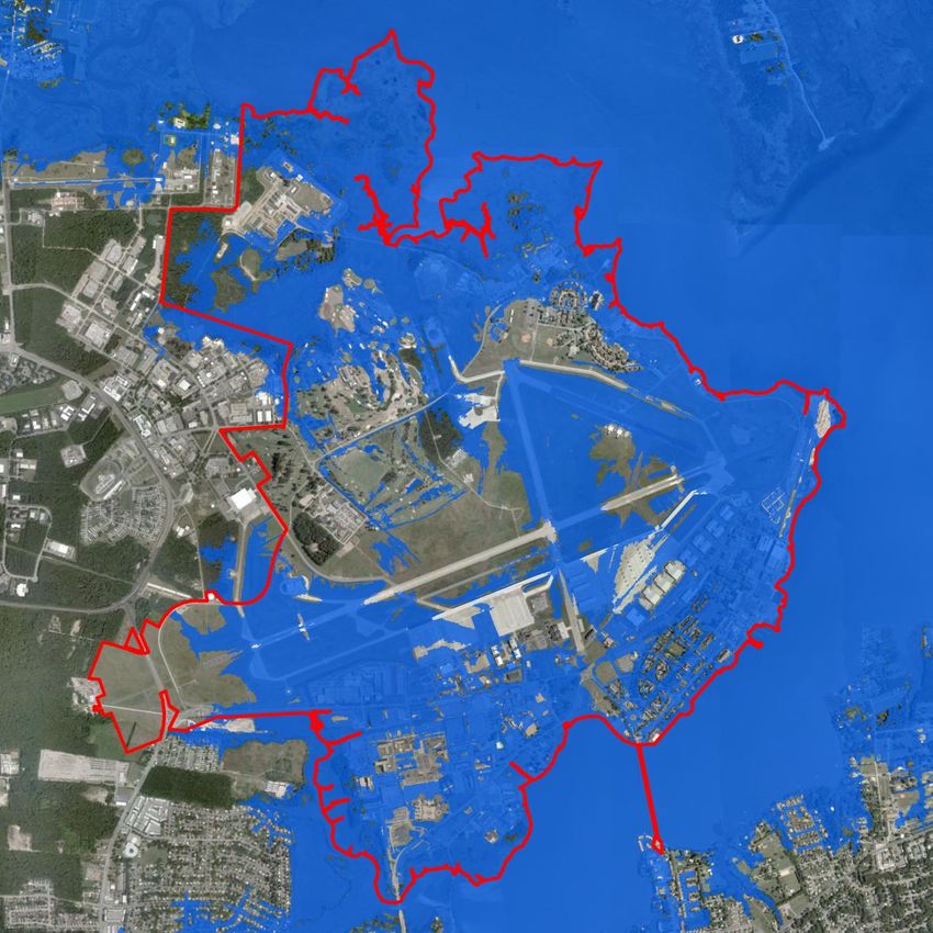
Sea-level Rise
Indeed, sea-level rise most likely represents the greatest climate change threat to Langley AFB. Nicholls
et al. (2007: IPCC AR4 WGII Chapter 6) concluded (with very high confidence) that globally coasts were
at increased risk for coastal erosion and other impacts as a consequence of sea level. This global concern
applies equally to coasts of the Mid-Atlantic region, Chesapeake Bay, and Langley AFB. Sea-level rise is a
topic of concern for the Chesapeake Bay and the US Atlantic Coast more generally (e.g., EPA, National
Wildlife Federation, USGS, Fish and Wildlife Service, Chesapeake Bay Program, US Climate Change
Science Program, US National Assessment, Maryland Department of Natural Resources)

The IPCC AR4 (WGI Chapter 10: Meehl et al. 2007) projected global mean sea level rise by 2100 of 7-15
in (19-37 cm) for the B1 scenario, 9-19 in (23-47 cm) for the A1B scenario, and 11-23 in (28-58 cm) for
the A1FI. An allowance for contribution from potential ice- sheet dynamics based on growing concern
about the stability of the Greenland and West Antarctic ice sheets adds to the upper end of the
projections. With this allowance sea level could increase by up to 31 in (79 cm) by 2100 (WGI Chapter
10: Meehl et al. 2007, ACECRC 2008). Current observed rates of sea-level rise are comparable to those
at the upper end of the AR4 projections (ACECRC 2008). They are also very comparable to the even
higher rates of projected sea-level rise reported in the 2001 IPCC TAR. Models in that analysis, after
accounting for land ice (Greenland and West Antarctic ice sheets) generated increases in sea-level of
nearly 3 ft (35 in; 88 cm) by 2100. The representation of land ice in global climate models is very
rudimentary, and there is concern that the stability of these ice sheets was overestimated in the IPCC
AR4 (Najjar 2009). Semi-empirical approaches by Rahmstorf (2007), tuned to the higher rates of sea
level rise observed in historical records, give much higher projections of 20-55 in (50-140 cm) (see Najjar
2009). Moreover, rates of observed sea level rise are not globally homogeneous, and regional
differences in future sea-level change are expected as well (Milne et al. 2009). Regional differences in
sea-level rise are due to changes in gravity, ocean currents and ocean density, as well as regional
differences in land subsidence. Historically sea level in the Northeast and Mid-Atlantic US has been
rising faster than the global average, most likely because of local land subsidence (Najjar 2009). The
region’s land subsidence could add as much as 11 in (27 cm) over global mean sea-level rise by the end
of the 21st century (Najjar 2009). Taken together, the higher rates of sea-level rise, potential
contributions of unstable land ice, and regional land subsidence, suggest that an increase in mean sea
level of 4 ft (48 in; 122 cm) for Langley AFB and the southern Chesapeake Bay region is on the upper
end, but entirely consistent with current projections of future sea-level rise.

Impacts of Sea-Level Rise
Flooding
The most straightforward impact of sea level rise is simple flooding or inundation. Coastal regions like
that of the Virginia Tidewater that are currently above sea level will be below sea level and flooded
depending upon the amount of sea level rise. Not surprisingly, low-lying coastal regions like that of
Langley AFB, with a mean elevation of 3 ft and “high” points of only 10-11 feet (e.g., the airfield
runways), are the most vulnerable to simple inundation. Langley AFB Site Plus 4 Feet illustrates the
flooding of Langley AFB assuming a 4 ft increase over mean sea level. Much of the installation is
inundated, perhaps as much as 40-50 percent, particularly at the margins. The extent of the flooding is
obvious even without reference to the image of the base at current mean tide (Langley AFB Site).

Some parts of Langley AFB already experience “flooding” at high tide or mean high water (MHW). The
marshes at the north of the base on the Northwest Branch of the Back River are most affected (Langley
AFB Site Plus MHW) by these normal tidal changes of more than 2 ft (Messick Point, Back River tides ).
Not surprisingly then, the addition of 4 ft above MHW results in almost total inundation of the base,
including much of the runway system (Figure 1).

        Figure 1. An illustration of future high tide flooding at Langley Air Force Base assuming a 4 foot increase in
        mean sea level. Also see Langley AFB Site Plus 4 Feet Plus MHW at Oak Ridge National Laboratory’s
        Langley Airbase Assessment.

There is even some expectation that tidal range in the Chesapeake Bay could increase with sea level rise
(Zhong et al. 2008), increasing by 15-20% at Baltimore, for example, with a 1 m sea-level rise (Najjar
2009). The simple conclusion is that 4 ft of sea level rise by 2100 could very well put operations at
Langley AFB at risk, particularly at high tide.
Indeed, extensive areas of the US Mid-Atlantic coast could be vulnerable to inundation with 3-4 feet of sea level (see Figure 2.4 of CCSP Synthesis and Assessment Product 4.1 CCSP 2009). As noted by Titus et al. (2009, p. 354), “Some low- lying railroads, tunnels, ports, runways, and roads [in the Mid-Atlantic region] are already vulnerable to flooding and a rising sea level will only exacerbate the situation by causing more frequent and more serious disruption of transportation services.” Erosion As intuitive and as readily visualized as simple inundation is, it is certainly not the only, nor the most significant impact of sea level rise on the coast (CCSP 2009 and see Table 6.2, page 322 of IPCC AR4 WGII Chapter 6: Nicholls et al. 2007). Increased beach or marsh erosion may also be a consequence. Attributing beach or other coastal erosion to observed historical sea level rise is difficult given the complexities and uncertainties of non-linear coastal geomorphological processes, coastal sediment budgets, variations in rate of sea level rise, and the contribution of subsidence and other factors including anthropogenic ones (IPCC AR4 WGII Chapter 6: Nicholls et al. 2007). Local variability in these factors compounds the problem. However, in principle and theory, based on fundamental understanding, any accelerated increase in sea-level rise is expected to increase coastal erosion, and coastal erosion is one of the more significant concerns of climate change impact on the world’s coastlines (IPCC AR4 WGII Chapter 6: Nicholls et al. 2007CCSP 2009). This concern applies to Langley AFB and the western shore of the Chesapeake as well as any other coastline. Coastal headlands, spits and barrier islands in sandy shore environments such as along much of the mid- Atlantic are particularly vulnerable (CCSP 2009) and “...it is virtually certain that erosion will dominate changes in shoreline position [along the mid-Atlantic ocean shores] in response to sea level rise and storms over the next century [p. 43, CCSP 2009 ].” The low-lying Factory or Northend Point at the mouth of the Back River where it enters Chesapeake Bay will likely be covered by a foot or more of seawater given 4 feet of sea-level rise. The island is only about 3 ft above sea level. But even before submergence, processes of erosion are likely to impact the island, and could compromise the protection from wave action in the Chesapeake that it provides the shores of Langley AFB. Loss of that protection would likely enhance or accelerate erosion of the waterfront at Langley AFB. The impact of sea level rise on coastal wetlands like the marshes surrounding Langley AFB is largely dependent upon the rate of sea level rise and the vertical development of the marsh/wetland in response to sedimentation and other processes. If sea level rise is slow the wetlands may keep up and remain closely-coupled or in equilibrium with mean sea level (Cahoon et al, Chapter 4, CCSP 2009). Rapid sea level rise can, however, “overwhelm” the processes of vertical development and become submerged, transforming marshes into tidal mudflats or open water (Cahoon et al, Chapter 4, CCSP 2009). Four feet of sea-level rise at Langley AFB would likely turn the marshes on the north of the base into open water. An assessment of the mid- Atlantic region based on an opinion approach by scientists with expert knowledge of wetland accretionary dynamics projected, with a moderate level of confidence, that those wetlands keeping pace with twentieth century rates of sea-level rise (Scenario 1 [12-16 in (30-40 cm) by 2100, comparable to the SRES B1 Scenario]) would survive a [1/16 in] 2 millimeter per year acceleration of sea-level rise (Scenario 2 [20-24 in (50-60 cm) by 2001, comparable to the SRES A1FI]) only under optimal hydrology and sediment supply conditions, and would not survive
a [1/4 in] 7 millimeter per year acceleration of sea-level rise (Scenario 3 [39-43 in (100-110 cm) by 2100,
above the upper end of current projections allowing for Greenland and West Antarctic contribution]).
There may be localized exceptions in regions where sediment supplies are abundant, such as at river
mouths and in areas where storm overwash events are frequent.” (Cahoon et al., Chapter 4, page 57,
CCSP 2009). The particular fate of marshes and wetlands around Langley AFB is then dependent upon
upstream supply of sediment from the southern end of the Virginia Peninsula, an area already heavily
impacted and influenced by development of Hampton and Newport News VA.

Beach and shoreline erosion obviously has implications for coastal infrastructure. Structures close to the
shore may actually be undercut or destabilized. They are also more at risk to flooding from storm surge
as erosion brings them closer to the shoreline. Erosion that removes protective dunes, beaches and
wetlands can also increase the risk of flooding (IPCC AR4 WGII Chapter 6: Nicholls et al. 2007). In
general, Titus et al. (2009. p. 28) concluded that: “With a substantial acceleration of sea-level rise,
traditional coastal engineering may not be economically or environmentally sustainable in some areas.”
Even before the inundation of Langley AFB with 4 ft of sea level rise by 2100, shoreline and marsh
erosion could affect the maintenance of base infrastructure. The animation of sea-level rise at Langley
Airbase Assessment provides some indication of where and when various parts of the base might be
impacted. Essentially all waterfront infrastructure appears susceptible, with no particular reach of
shoreline less vulnerable than others. And as the rise in sea-level continues more and more of the
Langley infrastructure becomes shoreline property!

However, the most significant impact of sea level on coastal regions is likely not the gradual erosion
accompanying an increase in sea level, but the episodic sometimes dramatic erosion and other damage
accompanying coastal storms and storm surge.

Storm Surge and Sea Level Rise
Storm surge is the water that is pushed towards shore by the winds of coastal storms, particularly
hurricanes (NOAA Storm Surge). The wind causes the water to pile up above normal sea level or tide
level, creating the storm tide. Wind driven waves ride atop this storm tide. Much of the damage, and the
greatest loss of life (NOAA Storm Surge), associated with hurricanes is a consequence of flooding and
wave damage from this storm surge and the accompanying waves, especially if the storm occurs at high
tide. Landfall of hurricanes is not a common occurrence in the southern Chesapeake, but because of its
low-lying elevation and flat topography Langley AFB is susceptible to storm tide flooding. The last
hurricane to impact Langley AFB was Hurricane Isabel in September 2003. Storm surge of 5-6 ft was
observed over the southern portion of the Chesapeake in the vicinity of Hampton Roads and Langley
AFB, Virginia (National Hurricane Center). The tidal surge as well as rainfall accompanying the hurricane
caused significant flooding of Langley AFB (see Hurricane Isabel at Langley AFB). Storm surge maps
produced by the Hampton Roads Emergency Management Committee do not explicitly include Langley
AFB, but from the maps of the surrounding area (see Hampton Roads region, Hampton) it is clear that
most or all of Langley AFB is vulnerable to storm surge accompanying Category 1 and 2 hurricanes.
Hurricane Isabel was a Category 2 storm at landfall (National Hurricane Center). The most significant
tropical cyclones to impact the region prior to Isabel were Hurricane Hazel in 1954 and the Chesapeake-
Potomac Hurricane of 1933 (National Hurricane Center). While not a frequent occurrence, Langley AFB
is vulnerable to storm surge damage when they do occur. Future sea-level rise and climate change is
likely to exacerbate that vulnerability.

As a first approximation, future storm surge can be estimated as current or historical storm surge plus
the projected rise in sea level (Dasgupta et al. 2009 ). Thus, even with no increase in future storm
intensity, the flooding and damage associated with future storms is likely to increase as the storm tide
increases. For example, if current high tide is 2 ft above mean sea level, a 10 ft storm surge arriving at
high tide creates a storm tide of 12 ft. With an increase in sea level of 2 ft the same intensity storm will
have a storm tide of 14 ft. If sea walls, levies, or other infrastructure are built with little tolerance above
historically experienced storm tides, a storm surge that was “contained” historically may well
overwhelm storm defenses in the future (Titus et al. CCSP 2009 ). A storm surge of 5-6 ft as
accompanied Hurricane Isabel, on top of a 4 ft sea-level rise, would completely inundate Langley AFB,
particularly if it occurred at high tide. The image of Langley AFB in Figure 1 above and Langley AFB Site
Plus 4 Feet Plus MHW would be completely blue for at least the duration of the storm surge.

The impact of sea level rise on storm surge is inversely proportional to the intensity of the storm. An
increase in sea level of 2 ft means a doubling of the storm tide associated with a tropical storm with a
storm surge of 2 ft. For the same level of sea level rise, the storm tide of a severe hurricane with a storm
surge of 15 ft only increases by 13%. The additional impact of sea level, if any, is likely to be more
significant with less severe storms. On the other hand, it is the larger storm surge of more severe storms
that are likely to overwhelm storm defenses, and where only a small relative change in storm surge can
mean the difference between containment and “over topping” of a levy. In general, even if coastal
storms of the future are no different from those of the past, no less intense, no more frequent, the
potential damage from those storms will increase as sea level rises. The specific nature of that increased
impact depends of course upon the geomorphology, storm defenses and infrastructure of the coast
where the storm surge occurs, but clearly there is a threshold in damage when the increased storm
surge exceeds storm defenses. Langley AFB is vulnerable to storm surge because of its geomorphology
and virtual absence of specific storm defenses (e.g., levies). Any natural protection from Factory or
Northend Point at the opening of the Back River to the Chesapeake Bay and the Atlantic Ocean will likely
be compromised as that island falls prey to inundation and erosion from sea-level rise. It is reasonable
to expect that continued operations of Langley AFB will have to adapt and compensate for that potential
loss and the greater risk of storm surge damage accompanying sea-level rise.

Unfortunately, from the perspective of climate change impact on Langley AFB or other coastal systems,
the increase in sea level is likely to be accompanied, at least globally, by increases in the intensity of
both tropical and extra-tropical storms (IPCC AR4 WGI Chapter 10: Meehl et al. 2007). Changes in other
storm properties are less certain (IPCC AR4 WGI Chapter 10: Meehl et al. 2007, IPCC AR4 WGII Chapter
6: Nicholls et al. 2007), but more intense storms suggest higher storm surge and more extreme wind
driven waves. As described above, sea level rise exacerbates the potential damage from more intense
storms. The combination of sea level rise and increased storm intensity is likely to increase the damage
to coastal systems and the vulnerability of Langley AFB to both tropical and extra-tropical storms. Only a
decrease in storm frequency or the frequency of landfall or a change in geographical distribution of
landfall will mitigate that increased impact. Projection of any of these mitigating factors is highly
uncertain if not virtually impossible using current generation global climate models. Specific assessment
of increased risk of tropical and extra-tropical storm impacts on the Atlantic and other coasts of the
USNORTHCOM AOR can be found in the QDR Climate Change Support NORTHCOM Coastal Areas
assessment . However, Titus et al. (CCSP Synthesis and Assessment Product 4.1 CCSP 2009, p. 537)
concluded: “Many coastal areas in the United States will experience an increased frequency and
magnitude of storm-surge flooding and coastal erosion due to storms over the next century, in response
to sea-level rise [emphasis added].” The existing vulnerability of Langley AFB suggests that if the
southern Chesapeake Bay and the Virginia Tidewater is one of these areas, Langley AFB is likely to be
negatively impacted by increased storm damage on top of the impact of widespread inundation
accompanying a 4 ft increase in sea level.

Other impacts of sea-level rise
Sea level rise can impact coastal regions in ways beyond the more visible flooding, erosion and storm
damage. As highlighted by the QDR Climate Change Support NORTHCOM Coastal Areas assessment the
2009 CCSP report on coastal sensitivity to sea level rise (CCSP 2009) found:

1.     “Rising sea level can elevate the water table (ground water) to the point where septic systems
no longer function properly.” (p. 520)

2.     “Sea-level rise may also exacerbate pollution through inundation of upland sources of
contamination such as landfills, industrial storage areas, or agricultural waste retention ponds.” (p. 240)

Either of these changes could impact Langley AFB operations and maintenance.

The report also found (CCSP 2009, p. 60) that “Rising sea level is causing saltwater intrusion into
estuaries and threatening freshwater resources in some parts of the mid-Atlantic region.” Similarly,
“’Ghost forests’ of standing dead trees killed by saltwater intrusion are becoming increasingly common
in southern New Jersey, Maryland, Virginia, Louisiana and North Carolina.” With continued increases in
sea level rise, those trends are likely to continue. Saltwater intrusion could put Langley freshwater
resources at risk, depending upon the sources of that freshwater. Ghost forests or other altered
vegetation could affect the aesthetics of Langley AFB.
You can also read