Lead Local Flood Authority Section 19 (Flood and Water Management Act 2010) Flood Investigation Report
←
→
Page content transcription
If your browser does not render page correctly, please read the page content below
Lead Local Flood Authority
Section 19 (Flood and Water Management Act
2010)
Flood Investigation Report
Report Title:
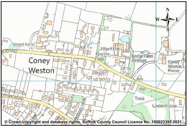
The Street, Coney Weston, Suffolk
Report Reference(s):
FW2020 - 2258
Name Date
Lead Officer: Hannah Purkis
Created by: Hannah Purkis 12/01/2021
Checked by: Simon Curl 02/02/2021
RMA Review: Anglian Water 09/04/2021
SCC Highways
Approved by: Matt Hullis 12/04/2021
Date Published 13/04/20211.0 Suffolk County Council (SCC) as a Lead Local Flood Authority (LLFA) has
determined that in accordance with criteria, it considered it necessary or
appropriate to carry out an investigation into this flood event in accordance with
Section 19 (1) of the Flood and Water Management Act 2010, and in
accordance with Section 19 (2) of the Flood and Water Management Act 2010,
to publish the results and notify the relevant risk management authorities
(RMAs).
2.0 Reference: FW2020 - 2258
2.1 Location: The Street, Coney Weston, Suffolk
2.2 Flood Event Date: Various, from 07/01/2016 to 11/01/2021
2.3 Reported to SCC Date: 11/01/2021
2.4 Investigation Commencement Date: 12/01/2021
2.5 Criteria for investigation:
Criteria for an investigation ✓/ X
(as per Appendix D of the Suffolk Flood Risk Management Strategy):
There was a risk to life as a result of flooding? -
Internal flooding of one property (domestic or business) has been ✓
experienced on more than one occasion?
Internal flooding of five properties has been experienced during one -
single flood incident
Where a major transport route was closed for more than 10 hours as a -
result of flooding
Critical infrastructure was affected by flooding -
There is ambiguity surrounding the source or responsibility of a flood -
incident
1|PageFigure 1 - Investigation Area Map
2.6 OS Grid Reference: TL 95770 78079
2.7 Extent of flooding:
Repeated incidents of highway flooding within The Street to a depth of
approximately 200-300mm for a distance of over 30m throughout December
2020 and January 2021.
Ditches adjacent to the highway reported to be at or over capacity and
overflowing onto the highway from overland runoff from adjacent fields. Both
flooding from the highway and overflowing ditches was reported to be
encroaching into private gardens.
4 No. properties were also reported to have experienced internal flooding,
where water levels reached a significant depth.
2.8 Effect of flooding:
A nearby Anglian Water foul water pumping station flooded and failed resulting
in sewage mixed in with the accumulated depths of surface water runoff.
Ground floor flooding in multiple properties (including at least one with ground
floor sleeping accommodation) to depth of 100mm and damage to internal
furnishings and furniture.
2|PageExtensive flooding to private driveways, gardens and outbuildings causing
damage to various stored items.
Highway reported to be impassable by pedestrians or cars for several days,
limiting access to properties. Cars and small vans needing to be towed out of
floodwaters having tried to drive through deep water.
2.9 History:
The highway (The Street) and adjacent garden land and properties have been
reported to have flooded previously, most notably in the early part of 2016.
Significant works to cleanse highway drainage were carried out by SCC
highways, with no subsequent reports of flooding from mid 2016 (following the
works) to late 2020.
2.10 Flooding Source:
Surface water runoff from adjacent land (overland flow), roads and highways.
2.11 Likely causes:
Significant rainfall event coupled with known risk of surface water flooding
locally.
Cohesive nature of underlying geology contributing to overland flow alongside
modern-day farming practices increasing runoff and volume.
Insufficient number of ordinary watercourses to capture overland flow and
culverting of the watercourses beneath private driveways, which reduces
capacity for conveyance and/or storage.
Insufficient or lack of maintenance within roadside ditches, both those under
local landowner riparian responsibility and SCC Highways responsibility leading
to overgrown watercourses which have less capacity for conveyance and/or
storage.
Siltation and general deterioration of highways drainage within The Street, as
evidenced by survey both in 2020 and historically in 2016.
Partial failure of Anglian Water pumping station contributing to volumes of
floodwater.
2.12 Additional Information:
Multiple incidents of surface water flooding were reported at ‘’Three Ways’’, at
the meeting of Rushford Road, Thetford Road and The Street, located
approximately 400m upstream, in a westerly direction, of the Anglian Water
pumping station and surrounding properties which are the focus of this report.
3|PageThe surface water flooding relates to a number of roadside ditches which
become culverted downstream of ‘’Three Ways’’ and head towards the centre
of Coney Weston. This is likely to be have been a factor in the flooding which
forms the basis of this investigation.
The majority of the flooded properties are shown to be at risk of flooding from
surface water on the indicative flood map for planning as hosted by the GOV.UK
website.
Highway gullies along The Street are reported to have been surcharging during
the storm event resulting in water flowing down the highway and contributing to
overland flow from adjacent greenfield areas.
Reported issues of the Anglian Water foul sewer and pumping station
surcharging, this could have been partly contributed to by the ingress of surface
water into the foul sewer. Anglian Water are aware of the issue and are
investigating. Therefore, this will not be considered further within this report but
is flagged up as an Action in the table below for completeness.
3.0 Risk Management Authority with Relevant Flood Risk Function
SCC –LLFA
SCC – Highways Authority
Anglian Water Services – Sewer Maintenance and Asset Owner
Local Landowners – Riparian Responsibilities
4.0 Recommendations:
Responsible Timescale Latest Progress
Action
Authority for response Update for Actions
Investigate and maintain Anglian Water Completed Anglian Water
foul sewer in the Services Services attended
highway and pumping Dec 2020
station
Dig out surface water SCC Highways Completed Pond cleared out as
storage feature (pond) /Riparian of Jan 2021
Owners
4|PageInvestigate ownership SCC Highways Completed SCC Highways have
and maintenance concluded that the
responsibilities of watercourse in
ordinary watercourse at question is for SCC
upper end of The Street to maintain
Regrade/improve SCC Highways April 2021
roadside ditches under
their ownership
Cleanse & survey SCC Highways April 2021
highways drainage
system
Explore potential options Property 3 months N/A
for property level Owners
resilience measures and supported by
funding opportunities SCC LLFA
Riparian owners to clear Riparian 3 months
ordinary watercourse Owners
supported by
SCC LLFA
Capital scheme to SCC Highways 12- 24
improve highways months
drainage within The
Street
5|PageYou can also read