Learning to Interpret Satellite Images in Global Scale Using Wikipedia
←
→
Page content transcription
If your browser does not render page correctly, please read the page content below
Learning to Interpret Satellite Images in Global Scale Using Wikipedia
                                         Burak Uzkent1∗ , Evan Sheehan1 , Chenlin Meng1 , Zhongyi Tang2 , David Lobell2 , Marshall Burke2 ,
                                                                                   Stefano Ermon1
                                                                1
                                                                  Department of Computer Science, Stanford University
                                                             2
                                                               Department of Earth Systems Science, Stanford University
                                                buzkent@cs.stanford.edu, {esheehan, chenlin, zztang, dlobell, mburke}@stanford.edu,
                                                                                ermon@cs.stanford.edu
arXiv:1905.02506v2 [cs.CV] 11 May 2019

                                                                     Abstract                                   Because direct annotation is expensive, researchers have
                                                                                                             considered many creative ways to provide supervision with-
                                                 Despite recent progress in computer vision, fine-           out explicit labels. These include unsupervised [9], label-free
                                                 grained interpretation of satellite images remains          [19; 25], and weakly supervised learning methods [18]. A
                                                 challenging because of a lack of labeled training           particularly effective strategy is to leverage co-occurrence
                                                 data. To overcome this limitation, we construct a           statistics in a dataset, e.g., predict the next frame in a video, a
                                                 novel dataset called WikiSatNet by pairing geo-             missing word in a sentence [14], or predict relationships be-
                                                 referenced Wikipedia articles with satellite imagery        tween entities such as images and text co-occurring together.
                                                 of their corresponding locations. We then propose           For example, leveraging images and their hashtags on Insta-
                                                 two strategies to learn representations of satellite        gram, [13] build a large scale image recognition dataset con-
                                                 images by predicting properties of the correspond-          sisting of more than 3 billion images across 17,000 weak la-
                                                 ing articles from the images. Leveraging this new           bels obtained from textual hashtags and their WordNet [15]
                                                 multi-modal dataset, we can drastically reduce the          synsets. After pre-training on this extremely large dataset,
                                                 quantity of human-annotated labels and time re-             they report almost 5% improvement over the same model
                                                 quired for downstream tasks. On the recently re-            trained from scratch on ImageNet.
                                                 leased fMoW dataset, our pre-training strategies
                                                                                                                Because satellite images are geolocated, i.e., they corre-
                                                 can boost the performance of a model pre-trained
                                                                                                             spond to specific locations (and times), they can be paired
                                                 on ImageNet by up to 4.5% in F1 score.
                                                                                                             with other geolocated datasets (e.g., OpenStreetMap [7]), ex-
                                                                                                             ploiting spatial co-occurrence statistics as a source of super-
                                         1       Introduction                                                vision [23; 22]. Following this strategy, we construct a novel
                                                                                                             multi-modal dataset by pairing geo-referenced Wikipedia ar-
                                         Deep learning has been the driving force behind many recent         ticles with their corresponding satellite images. By treating an
                                         improvements in computer vision tasks, including image clas-        article as an information-rich label, we obtain highly detailed
                                         sification, image segmentation, object detection and tracking,      physical and qualitative context for each image. For exam-
                                         etc. [21; 12; 4; 29; 27; 28]. These deep models, however, re-       ple, the first sentence of the John. F. Kennedy International
                                         quire training on high quality, large-scale datasets, and build-    Airport article contains excerpts such as “JFK is the primary
                                         ing these datasets is typically very costly. Satellite images are   international airport serving New York City”. Wikipedia ar-
                                         particularly difficult and expensive to label because of hu-        ticles additionally contain demographic, environmental, and
                                         mans’ unfamiliarity with aerial perspectives [1].                   social information in structured form. To the best of our
                                            One effective way to reduce the amount of training data          knowledge, this is the first time that Wikipedia has been used
                                         needed is to perform pre-training on an existing, previ-            in conjunction with satellite images, and with 888,696 article-
                                         ously annotated dataset, such as ImageNet [3], and trans-           image entries, our approach yields the largest satellite image
                                         fer the learned weights to the domain of interest [17; 2;           dataset to date.
                                         30]. However, the success of this approach diminishes if
                                         the underlying distributions and/or compositions of the pre-           In this paper, we demonstrate the effectiveness of pairing
                                         training and target datasets are not sufficiently similar. Such a   Wikipedia articles to satellite images for pre-training CNNs
                                         problem is exceptionally pronounced in the satellite imagery        for satellite image recognition. We propose two pre-training
                                         space, as the entire frame of reference and perspective of an       methods to learn deep representations. First, similar to [13],
                                         aerial image is altered compared to a natural image. This has       we weakly label satellite images with curated summarization
                                         the unfortunate effect of rendering natural image datasets,         tags extracted from the article via an automated process. We
                                         such as ImageNet, less useful as pre-training mechanisms for        then train a deep convolutional network to predict these weak
                                         downstream computer vision tasks in the satellite domain [16;       labels directly from the images, learning useful representa-
                                         7].                                                                 tions in the process. In the second approach, we propose a
                                                                                                             novel joint architecture where we first obtain a textual em-
                                             ∗
                                                 Contact Author                                              bedding of each article using document summarization tech-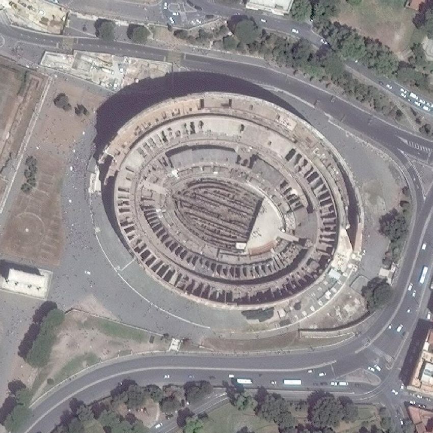
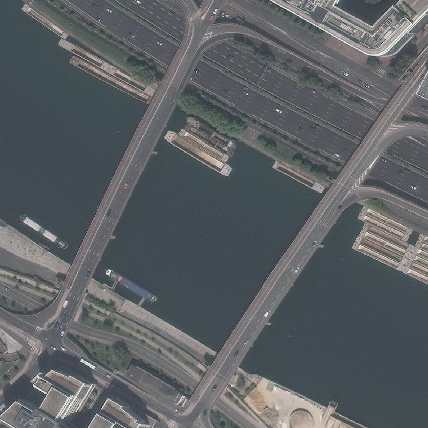
Port of Boston       Chrysler Building   Huvudstabron   Three Gorges Dam   Niagara Falls

                                                         JFK Airport         Maracanã Stadium      Taj Mahal      Hagia Sophia      Colosseum

Figure 1: Left: Scatter plot of the distribution of geo-tagged Wikipedia articles together with some images (right) matched to
the articles shown as green dots on the left plot. The title of the Wikipedia articles are written under each image. Zooming-in is
recommended for visualization.

niques from NLP [10] and then train a deep convolutional                 [1]. Note that one could also use the same strategy to build
network to produce an embedding for each image that is “sim-             a similar multi-modal dataset using lower-resolution (10 me-
ilar” to the textual one. The first approach is a crude way of           ter), publicly available Landsat and Sentinel-2 images. For a
getting a single weak label for each article whereas the second          given coordinate ci , there are usually multiple images avail-
learns representations without weak labels. The pre-trained              able, captured at different times. We acquired the latest image
networks are then evaluated on a downstream hand-labeled                 available. Another important design choice is the size of the
dataset, as in [6], where we obtain 4.5% higher accuracy com-            acquired images. In this study, we use 1000×1000 pixels im-
pared to networks pre-trained on ImageNet, the standard ap-              ages covering approximately an area of 900m2 . In aerial im-
proach for computer vision tasks.                                        ages, objects occupy drastically different numbers of pixels,
                                                                         as shown in Fig. 1. Based on preliminary manual examina-
2     Pairing Rich Crowdsourced Annotations                              tion, we found that 1000×1000 pixels images can typically
                                                                         cover most of the relevant objects. Finally, we prioritized col-
      from Wikipedia to Satellite Images                                 lecting RGB images and only acquired grayscale images if an
Wikipedia is a large-scale, crowdsourced database spanning               RGB image was not available. We did not perform any filter-
302 languages with over 47 million articles [32]. Of these 47            ing to remove cloudy images, as our goal is to learn robust
million articles, about 11% are contained in the English ver-            representations on a noisy dataset.
sion. Out of these approximately 5 million articles, we found               Our resulting WikiSatNet multi-modal dataset is a set of
that roughly 1 million, or nearly 20%, are geolocated, mean-             tuples D = {(c1 , x1 , y1 ), (c2 , x2 , y2 ), · · · , (cN , xN , yN )}
ing there is a latitude and longitude ci = {clat    lon
                                              i , ci } associ-           where each tuple (ci , xi , yi ) represents a location (ci ), corre-
ated with the article’s text yi . Our key idea is to use the ar-         sponding DigitalGlobe image (xi ) and Wikipedia article text
ticle’s coordinates to acquire a satellite image of its location         (yi ). WikiSatNet contains N = 888, 696 article-image pairs.
from space (see Fig. 1).                                                 To the best of our knowledge, this is the largest dataset to
   There is often a strong correlation between the article’s             date consisting of satellite images and about 2 times larger
text, yi , and the visual content of the corresponding image,            than the recently released large scale fMoW dataset. Note that
xi . Indeed, we can think of the article as an extremely de-             our procedure is highly scalable and fully automated. It could
tailed “caption” for the satellite image, providing an often             be used to generate even larger datasets by considering other
comprehensive textual representation of the satellite image,             Wikipedia languages and other sensors in addition to Digi-
or an information-rich label. This label often contains struc-           talGlobe. In the next section, we propose two novel methods
tured data in the form of tables, called infoboxes, as well as           to pre-train a convolutional neural network (CNN) to extract
raw text, allowing for the extraction of information about the           information about images xi using information from yi .
physical state and features of the entity (e.g., elevation, age,
climate, population).                                                    3      Learning Visual Representations using
2.1    Acquiring Matching Satellite Imagery                                     Wikipedia Textual Information
For a given article’s coordinate ci , there are many sensors             Exemplifying the diverse application possibilities highlighted
that can provide imagery, with different tradeoffs in terms of           in the previous sections, we construct a general Wikipedia
spatial and temporal resolution, wavelengths, and costs. In              article-satellite image framework for pre-training CNNs. We
this paper we acquire high resolution images from Digital-               then explore whether we can learn to interpret satellite im-
Globe satellites. The images have a ground sampling distance             ages using knowledge extracted from Wikipedia articles via
(GSD) of 0.3-0.5m. These are among the highest resolution                two approaches: weakly-supervised [18] labelling and a novel
images available commercially, and were also used in the re-             textual embedding method that attempts to match textual and
cently released functional map of the world (fMoW) dataset               visual embeddings.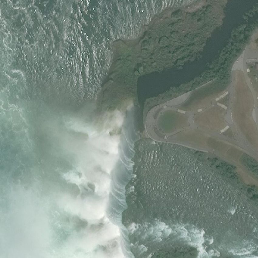
North Queensland           Highland                                  X 7→ RM that embeds images into an M dimensional fea-
                                                 Iserbrook
     Cowboys                Aviation                                  ture space, followed by fully connected and softmax layers
                                                                      as shown in Fig. 4a. In this study, we parameterize fv us-
                                                                      ing the DenseNet121 [5] architecture which was previously
                                                                      shown to perform well across a range of tasks. The classifier
                                                                      is trained using the cross entropy loss function. The features
                                                                      learned by the convolutional embedding fv on this large-scale
                                                                      pre-training task can then be transferred to downstream tasks,
        (event)            (school)            (incident)             e.g., object detection or land cover classification.
Figure 2: Some of the extracted weak labels representing                 Extracting weak labels is a noisy process that leads to a sig-
flipped label noise. Corresponding Wikipedia article titles are       nificant number of flipped labels as shown in Fig. 2. Addition-
written above the images. Though the words stadium, airport,          ally, the process leads to adversarial label noise because of
and water are mentioned 19, 6, and 23 times in the articles,          visually similar labels such as city, country, populated place,
our weak label extraction pipeline generates wrong labels.            building, town etc., as shown in Fig. 3. One can apply a sim-
Using image to text matching helps alleviate this flipped label       ple merging step to place such visually similar labels into a
noise.                                                                general category, e.g., populated place. However, it leads to
                                                                      a class imbalance problem where almost 40% of the dataset
                                                                      is dominated by populated places. Exploring the trade-off be-
                                                                      tween adversarial label noise and class imbalance problems is
                                                                      a very time-consuming process due to the nature of working
                                                                      with a large-scale dataset. For this reason, in the next sec-
                                                                      tion, we propose a novel, and practical method to learn deep
      (city)        (town)        (town)          (county)            representations using multi-modal data without manual pre-
Figure 3: Visually similar examples where the extracted weak          processing.
labels cause adversarial label noise. Here the CNN is penal-
ized for errors even when the predicted label is visually sim-        3.2   Image to Text Matching Learning
ilar to assigned weak label. In contrast, our document sum-           In this section, we propose a novel method to learn deep con-
marization model projects the embeddings of the articles of           volutional features without using hand-crafted labeling func-
these images to a similar space to avoid penalizing the CNN           tions. This not only substantially reduces human effort, but
when predicting a similar label.                                      also tackles the adversarial label noise by softening the loss
                                                                      function for the images that can fall into multiple visually
3.1   Weakly Supervised Learning                                      similar categories. Our method relies on the idea of image to
                                                                      text matching [11; 31]. In this direction, we propose a novel
We first propose learning visual features using a data-               network shown in Fig. 4b with two branches: a visual and
programming pipeline [18] to label our dataset. We begin by           a textual one. We design a loss function that encourages the
extracting a weak label ŵ(yi ) for each article yi in our dataset.   CNN (visual branch) to produce image embeddings that are
In our context, a weak label is a noisy, machine-generated            close to a suitable vector representation of the corresponding
classification of an article from a set of pre-defined labels.        article’s text (textual branch).
Because of space constraints, we only provide a high-level               The proposed architecture uses satellite images, X , and
description of the approach, and will add more details by pur-        Wikipedia articles, Y, as input. In the textual branch, we learn
chasing extra pages in the final version. As a first step, we         a function ft : Y 7→ RK , to project an article, yi , to a textual
manually compile a list of 97 potential categories that an ar-        embedding space zit ∈ RK using a document summarization
ticle could fall under (e.g., city, lake, event, etc.) and use        model from natural language processing (NLP):
regular expressions to search for the terms throughout spe-
cific areas of the article’s text where article meta-data is con-                               zit = ft (yi ).                     (1)
tained. We then rank the categories which are matched to the
article in a manually-constructed hierarchical fashion from           In the visual branch, we use a function fv : X 7→ RM pa-
specific to general (e.g., building −→ town −→ county,                rameterized using a convolutional neural network to extract
etc.) and choose the one which comes first to label the article.      features from an image as
Because many of these category labels are very detailed, we                                     ziv = fv (xi )                      (2)
then merge certain similar categories together to create more
general labels. We also discard articles that are assigned la-        where i represents the index of the image paired to article yi .
bels which cannot be determined from a satellite image (e.g.,         We parameterize fv using the DenseNet121 architecture [5]
person, event, etc.). Weak labels represented by less than            as in the weak supervision method. Next, we use a function
100 samples are also removed, reducing the final set of labels        fm : Z v 7→ RK to map ziv to the same dimension as the
to 55.                                                                textual feature vector zit . The function fm is parameterized
   Given the final set of weak labels and corresponding im-           using a fully connected layer with ReLU activations. The final
ages, we train a classifier to predict ŵ(yi ) from xi . The clas-    feature vectors, ziv and zit ∈ RK , are then compared with a
sifier is composed of a convolutional neural network fv :             loss function that enforces similarity.
Global
FCL
FCL
Global CNN Pooling
FCL
FCL
CNN Pooling
55 Finetune Weigths 1024 300
Loss
1024 Loss on Human Labeled Function
Bridge Mandela
Function Dataset
Weak D
Label Bridge
Extraction
Doc2Vec
300
(a) (b)
Figure 4: The workflow of the proposed weakly supervised learning method (a): (1) Extract labels from articles using our
labeling pipeline. (2) Match articles with images of their coordinates. (3) Pre-train on a large-scale dataset using 55 weak
labels. (4) Transfer learned weights to a down-stream task. In (b) we show the workflow of the image to text matching learning.
Our method enforces the CNN to learn features similar to raw textual features learned by Doc2Vec.
Pre-training the Doc2Vec Model Cosine Similarity Loss Function
Our image to text matching method uses textual descriptors After learning feature vectors, ziv and zit ∈ RK , from the
Z t to learn deep visual representations. In our study, we use two branch network, we apply a loss function to measure the
the Doc2Vec network [10] which can summarize variable similarity of the two vectors. We propose using the cosine
length articles in a unified framework. Doc2Vec is a docu- similarity metric, which measures the angle, θi , between two
ment summarization method that can take a variable length vectors as
piece of text, yi , and map yi ∈ Y to a paragraph vector fv (xi )T ft (yi )
zit = ft (yi ) ∈ RK in a fixed-length vector space, where D(xi , yi ) = cos(θi ) = . (3)
K is specified by the user. Documents that possess simi- kfv (xi )k2 kft (yi )k2
lar meanings are mapped to nearby points in the embedding Wikipedia has varying lengths of articles, which makes the
space, allowing a comparison between any two documents. cosine similarity function ideal since it measures the similar-
In contrast to fixed length vector representations using Bag- ity between the direction rather than the magnitude of two
of-Words, Doc2Vec can capture the orderings and seman- vectors.
tics of the words, which is highly beneficial for our unsu-
One can apply some other loss functions for our pre-
pervised learning task. For example, learning a textual em-
training task. For example, [31] proposed triplet loss function
bedding space where we can closely map article categories
where the anchor is a phrase paired to its corresponding posi-
such as country, city, town etc. is desired considering that
tive visual data. The negative image is then sampled from the
their corresponding visual data contain similar structures (see
neighborhood of the positive sample. [6] adapted triplet loss
Fig. 5). Another advantage of the Doc2Vec model is that it
function for unsupervised learning on satellite images. They
is an unsupervised learning model. This allows us to learn
assign a positive image for each anchor image from its spatial
Wikipedia-specific descriptors by training it on the full ge-
neighborhood following the assumption that nearby images
olocated Wikipedia article corpus.
contain similar visual structures. The negative sample is then
sampled from the areas outside the anchor’s neighborhood
circle. In our case, we lack explicit knowledge that can help
City - Middletown, Connecticut
1.00 city town City - Milton, Georgia
us sample negative image given an article, yi , as anchor and
town
city Lake - Timothy Lake its corresponding image, xi , as positive. In this direction, one
0.75
Lake - Tinquilco Lake can compute the similarity in the visual, zv1 , or textual, zt ,
person Town - Mingona Township, Barber County,
0.50
embedding space between a positive sample and other sam-
0.25
Kansas
Town - Moon Township, Allegheny County, ples in a certain spatial neighborhood to get a negative sam-
0.00 island Pennsylvania ple.
island Road - Morehampton Road, Dublin
−0.25 Another interesting aspect of our architecture is the di-
road Road - Motorway M10 Pakistan
−0.50 river road
River - Motru River
mensionality of the textual embeddding space. We believe
river
−0.75 lake
lake River - Mousam River that 300 dimensional feature vector can capture all the fine-
−0.5 0.0 0.5 1.0
Island - Aupaluktok Island grained visual structures in an aerial image. However, dur-
Island - Avatanak Island ing our experiments we observed that visually similar fea-
tures can lead to more uniform textual descriptors slowing
Figure 5: Visualization of PCA components of the randomly
down the learning process. Thus, using a smaller dimensional
chosen articles learned by Doc2Vec. Notice that visually simi-
embedding space can lead to more discriminative visual fea-
lar objects such as city, town are closely mapped while differ-
tures that can potentially speed up the learning process. On
ent objects are projected far away. Corresponding Wikipedia
the other hand, this can also prevent the CNN from learn-
article titles are shown on the right.
ing fine-grained in- formation. We leave the task of exploring
this trade-off as a future work of our study. Another future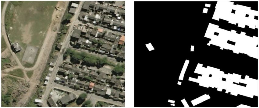
dimension of our image to text matching work is generating
                                                0
a Wikipedia article, yi , using an NLP decoder ft given visual
representations xi as
                              0
                       yi = ft (fv (xi )).                   (4)

Training on WikiSatNet
In our pre-training experiments, we use similar hyper-
parameters in both weak supervision and image to text match-
ing to train the DenseNet121 for optimizing the weights for         Figure 7: Visualization of cosine similarities learned by the
fv . We initialize weights randomly, however, we observed           CNN. The cosine similarities between the CNN embeddings
faster convergence when initializing with pre-trained weights.      and the Doc2Vec embedding are computed and overlaid on
After experimentation, we set the learning rate and batch size      the images. The CNN learns to embed AT&T Stadium’s im-
to 0.0001 and 64, respectively, and the Adam optimizer is           age closer to the its corresponding article.
used to train the model [8]. Finally, we resize the 1000×1000
pixels images to 224×224 pixels images to compare with
publicly available datasets.                                        4     Transfer Learning Experiments
                                                                    After pre-training CNNs on WikiSatNet using the proposed
                                                                    methods, we test them on three target tasks: (1) single image
                                                                    classification on the fMoW dataset, (2) temporal view clas-
                                                                    sification using multiple images over an area on the fMoW
                                                                    dataset, and (3) land cover classification. In these tasks, we
                                                                    compare our pre-training strategies to the following base-
                                                                    lines: (1) pre-training on ImageNet [21], (2) pre-training on
                                                                    CIFAR10, and (3) training from scratch. Our goal is to eval-
                                                                    uate whether we learn satellite-specific representations that
                                                                    outperform the ones obtained using out-of-domain bench-
                                                                    marks with human labels.
                                                                    Fine-tuning
Figure 6: Some of the cloudy images in WikiSatNet. The              There are two classical approaches in fine-tuning a deep net-
cloudy images amount to roughly 5-7% of the dataset.                work on the target task: (1) training all layers, and (2) freez-
                                                                    ing all the layers other than the final classification layer. In
                                                                    our experiments, we present results from both strategies. The
   In the initial steps of image to text training, we observe       learning rates for the weakly supervised and image to text
an angle of approximately 90o (D(xi , yi ) ≈ 0) between zit         matching model are set to 1e-4 and 1e-5 after experimenta-
and ziv . This is consistent with the fact that random vectors in   tion. On the other hand, the learning rate for the ImageNet
high dimensional spaces are likely to be orthogonal to each         model is set to 1e-4, while it is set to 1e-3 for both the CI-
other. After several epochs, the angle decreases to about 45o       FAR10 pre-trained and trained from scratch models. These
(D(xi , yi ) ≈ 0.5) and stops decreasing further. We believe        were the best performing hyper-parameters in our experi-
that this is partially due to articles that do not contain any      ments. Finally, resized 224×224 pixel RGB images are used
visual cue, e.g culture and person, and also cloudy images          as input to the model as in the pre-training task. We follow
(see Fig. 6), which amount to roughly 5% of the dataset. We         the same approach for the models pre-trained on CIFAR10
did not observe over-fitting in our experiments. While we are       and ImageNet.
not able to achieve zero loss, we qualitatively find that our
approaches learn meaningful representations. To verify this,        4.1    Experimenting on the fMoW Dataset
after pre-training the CNN on WikiSatNet using the image to         To quantify the quality of the representations learned in the
text matching, we visualize the cosine similarities between zit     pre-training step, we first use a recently released large-scale
and ziv as shown in Fig. 7. In the same figure, we keep zt          satellite image recognition dataset named fMoW [1]. The
fixed and use embeddings from images at different locations.        fMoW dataset consists of both multispectral and RGB im-
The CNN learns to project embedding ziv closer to its corre-        ages and contains 83,412 unique training bounding boxes
sponding article embedding zit . We will publicly release the       from large satellite images representing 62 different objects.
code for our image to text matching and weak supervision            The validation and test sets contain 14,241 and 16,948 bound-
methods upon publication. Additionally, we expect to release        ing boxes and are left unchanged in our experiments. It also
a substantial fraction of the high resolution images in Wik-        comes with temporal views from the same scenes, making
iSatNet (negotiations on the license with the image provider        classification of some classes such as construction site and
are ongoing). This will encourage further research into jointly     flooded road easier. [1] proposes a multi-modal architecture
utilizing Wikipedia and satellite images.                           that uses a DenseNet161 pre-trained on ImageNet and an
WikiSatNet WikiSatNet
Model CIFAR10 ImageNet
Weak Labels Image2Text
Top-1 Acc.
70
13.98 (%) 37.73 (%) 50.73 (%) 51.02 (%)
90 (Fixed fv )
Top-1 Acc.
60 80 55.79 (%) 68.61 (%) 70.62 (%) 70.72 (%)
(Fine-tuned fv )
Top 1 Accuracy
Top 5 Accuracy
50 70
Table 1: Top-1 accuracies on the fMoW test set for pre-trained
40 60
From Scratch From Scratch models. All the models are fine-tuned on the full fMoW train-
CIFAR10 CIFAR10
30 ImageNet 50 ImageNet ing set. Fixed fv represents the fine-tuning method where the
WikiSatNet WikiSatNet pre-trained weights are fixed whereas the second method fine-
20 Weak Supervision 40 Weak Supervision
WikiSatNet WikiSatNet tunes all the layers.
Image2Text 30 Image2Text
10
10 50 100 200 350 10 50 100 200 350
Number of Samples (*103) Number of Samples (*103) Reasoning on Temporal Views
In this section, we evaluate our representations on the task of
Figure 8: The top-1 and 5 classification accuracies of the pro-
temporal view classification across 62 classes from the fMoW
posed pre-training and baseline strategies on fMoW’s test set
dataset. This way, we can understand if our pre-training meth-
when fine-tuning all layers on fMoW’s training set. Monte-
ods also boost performance on tasks that use temporal data as
Carlo experiments were conducted when sampling a subset
input. [1] trains the network on single labeled images and at
of the full training set.
test time averages the softmax predictions of the network on
different images from the same area to assign the label with
the maximum average score. We follow their training and test
LSTM to learn from images and their corresponding meta-
methods and at test time average predictions from T images
data. Their DenseNet161 model has a number of parameters
over the same area, again using features extracted from fv (·)
similar to the DenseNet121 model we use in our experiments.
as input. This can be formulated as
Since our pre-training framework learns from visual data, it
can be easily applied to any CNN model to boost performance XT
as well as reduce the number of labeled samples needed for a L(X) = argmax(mean( p(fv (xt )))) (6)
target task. j t=1
where j denotes the index of the assigned label and fv rep-
Reasoning on Single Images resents the pre-trained network fine-tuned on the fMoW. Dif-
In the first task, we perform experiments on the fMoW dataset ferent from the previous section, we now report results in F1-
for the task of classifying individual images using features scores to compare our models to the ones proposed by [1].
extracted by the visual branch fv (·) as
WikiSatNet WikiSatNet
L(xi ) = argmax(p(fv (xi ))) (5) Model CIFAR10 ImageNet
Weak Labels Image2Text
j F1 Score
55.34 (%) 64.71 (%) 66.17 (%) 67.12 (%)
(Single View)
where p represent the fully connected and softmax layers F1 Score
60.45 (%) 68.73 (%) 71.31 (%) 73.02 (%)
whereas j denotes the index of the assigned label. We experi- (Temporal Views)
ment with 2000, 10000, 50000, 100000, 200000, and 350000
training images. As shown in Fig. 8, our pre-training strate- Table 2: F1 scores of different pre-training methods on
gies outperform the other pre-training strategies by large mar- fMoW’s test set when fine-tuning all the layers on fMoW’s
gins in top-1 and top-5 classification accuracy when using training set.
small amounts of labeled data. For example, when using 2000
labeled images, both our training strategies outperform Ima- We first compare our pre-training methods to ImageNet
geNet and CIFAR10 by 10% and 30%, respectively. As ex- and CIFAR10 pre-training in Table 2. The proposed pre-
pected, this number goes down to about 5% and 20% when training methods outperform the ImageNet pre-trained model
increasing the number of labeled images to 50000. Interest- by up to 4.5% in F1 Score when performing reasoning on
ingly, at this point, the model trained from scratch starts to temporal views. Among the proposed methods, the image
outperform the model pre-trained on CIFAR10. When using to text matching approach outperforms the weak supervision
the full training set, our proposed pre-training strategies out- with handcrafted labels method by about 1.7% in F1 Score.
perform ImageNet by about 2% and outperform the model These results prove that the importance of pre-training does
trained from scratch by about 10%. These results demon- not diminish when switching from single to temporal views.
strate that our proposed approach produces features that are On the other hand, [1] proposes five different models for the
highly beneficial in down-stream tasks involving satellite im- fMoW classification task. Three of them use meta-data and
ages, even when large numbers of human labeled samples are images jointly, whereas the remaining two only employ an
available. When fine-tuning only the final layer, the proposed ImageNet pre-trained DenseNet on images. Their visual data-
pre-training methods outperform ImageNet features by about only models are named CNN-I-1 and CNN-I, where the for-
13% on the test set as shown in Table 1. mer is a single view model and the latter performs tempo-
Pretrained
DenseNet DenseNet
DenseNet Block
Block Block
Upsampler Upsampler Upsampler
(112x112) (56x56) (28x28) (56x56) (112x112) (224x224)
1x1
1x1
Figure 9: The proposed segmentation architecture that uses the pre-trained weights in the encoder stage.
ral reasoning. We can improve these models with our pre- semantic segmentation target task. Image recognition focuses
training strategy by about 4.5% in F1 score while perform- on global features to associate an image xi with a label wi .
ing similarly to their top performing model, LSTM-IM, which On the other hand, in semantic segmentation, local features
uses meta-data and visual data jointly to perform temporal play more important role in associating a pixel xi (m, n) with
reasoning. Although this is outside the scope of this paper, a label wi where m and n represent the column and row in-
our pre-trained models can replace the DenseNet model, pre- dex.
trained on ImageNet, used in LSTM-IM to improve its results We first build a semantic segmentation network using the
as well. DenseNet121 model pre-trained on WikiSatNet. A typical
Our experiments demonstrate that pre-training with weak segmentation model consists of encoder-decoder steps to gen-
or no supervision is very useful for the target task as reported erate segmentation maps with the same size to input images.
by [13] both in terms of (1) boosting accuracy and (2) reduc- In this case, we use the pre-trained weights fv as encoder
ing the required human labeled dataset size on the target task. and design a decoder architecture on top of fv as shown in
Unlike the pre-training framework proposed by [13], we do Fig. 9. The proposed architecture is similar to U-Net archi-
not necessarily need to have billions of images to overcome tecture [20], however, we use the DenseNet121 pre-trained
noise to learn useful representations. on WikiSatNet in the decoder stage. This is important as it
requires a complex network to learn from large-scale datasets
4.2 Experiments on Land Cover Classification such as WikiSatNet. On the other hand, the U-Net employs a
Additionally, we perform classification across 66 land cover shallow encoder, preventing us to pre-train it on the WikiSat-
classes using remote sensing images with 0.6m GSD ob- Net. We perform experiments on the SpaceNet [24] semantic
tained by the USDA’s National Agriculture Imagery Program segmentation task on the satellite images. The SpaceNet con-
(NAIP). We focus on the images from the California’s Central tains training and test set from six different cities, and build-
Valley near the city of Fresno for the year 2016. The corre- ing and road masks for corresponding high resolution (0.3-
sponding land cover map, named the Cropland Data Layer 0.5m GSD) DigitalGlobe images. In this study, we focus on
(CDL), is collected by the USDA for the continental United the Rio set and building masks. There are about 5000 training
States [26]. The CDL is provided at 30m GSD, and we up- and 800 test images coming from the city of Rio de Janeiro.
sample them to match 0.6m GSD to use as ground truth. The We experiment with varying number of training samples to
final dataset consists of 100000 training and 50000 valida- quantify the learned representations in the case of using dif-
tion and test images. We only fine-tune the classification layer ferent amount of labeled samples in the target task. However,
while keeping fv fixed. we keep the test set unchanged in our experiments. Table 4
shows the Intersection-over-Union (IoU) scores of the pro-
Model CIFAR10 ImageNet
WikiSatNet WikiSatNet posed segmentation architecture (see Fig. 9) when pre-trained
Weak Labels Image2Text on ImageNet and WikiSatNet.
Top 1 Acc. 42.01 (%) 40.11 (%) 46.16 (%) 47.65 (%)
Top 5 Acc. 74.73 (%) 80.15 (%) 88.66 (%) 88.77 (%)
Table 3: Performance of different pre-training methods on the
land cover classification task.
As shown in Table 3, our pre-training strategies lead to
substantially higher performance than the ImageNet and CI-
FAR10 features. This demonstrates the robustness and wide
range of applications our pre-training strategies possess.
4.3 Experiments on Semantic Segmentation Figure 10: An example of a building mask for a satellite im-
Previously, we explored image recognition in both pre- age in SpaceNet Rio dataset.
training and target tasks. In this section, we change the target
task type to semantic segmentation to understand if image As shown in Table 4, the pre-training provides significant
recognition pre-training can still boost the performance on boost when fine-tuning on small amount of training samples
WikiSatNet             salient and category-specific object detection: a survey.
Model             From Scratch      ImageNet
                                                   Image2Text             IEEE Signal Processing Magazine, 35(1):84–100, 2018.
200 Samples         42.11 (%)       50.75 (%)       51.70 (%)      [5]    Gao Huang, Zhuang Liu, Laurens Van Der Maaten,
500 Samples         48.98 (%)       54.63 (%)       55.41 (%)             and Kilian Q Weinberger. Densely connected convolu-
5000 Samples        57.21 (%)       59.63 (%)       59.74 (%)             tional networks. In 2017 IEEE Conference on Computer
                                                                          Vision and Pattern Recognition (CVPR), pages 2261–
Table 4: The IoU scores of different pre-training methods on              2269. IEEE, 2017.
building segmentation task.
                                                                   [6]    Neal Jean, Sherrie Wang, George Azzari, David Lobell,
                                                                          and Stefano Ermon. Tile2vec: Unsupervised represen-
(200, and 500 samples). However, pre-training on the Wik-                 tation learning for remote sensing data. arXiv preprint
iSatNet only achieves slightly higher IoU than ImageNet.                  arXiv:1805.02855, 2018.
These results are consistent with the previous studies where       [7]    Pascal Kaiser, Jan Dirk Wegner, Aurélien Lucchi, Mar-
pre-training and target datasets contain different level tasks            tin Jaggi, Thomas Hofmann, and Konrad Schindler.
[13]. For example, [13] explored the idea of pre-training on              Learning aerial image segmentation from online maps.
image recognition task and transferring the learned weights               IEEE Transactions on Geoscience and Remote Sensing,
for the task of object detection. They report that such set up            55(11):6054–6068, 2017.
does not lead to significant performance increase as in the
                                                                   [8]    Diederik P Kingma and Jimmy Ba.               Adam: A
case where both pre-training and target tasks are the same-
level tasks (image recognition).                                          method for stochastic optimization. arXiv preprint
                                                                          arXiv:1412.6980, 2014.
5   Conclusion                                                     [9]    Diederik P Kingma, Shakir Mohamed, Danilo Jimenez
                                                                          Rezende, and Max Welling. Semi-supervised learning
In this study, we proposed a novel combination of satellite               with deep generative models. In Advances in Neural In-
images and crowdsourced annotations from geo-referenced                   formation Processing Systems, pages 3581–3589, 2014.
Wikipedia articles. To the best of our knowledge, this is the
                                                                   [10]   Quoc Le and Thomas Mikolov. Distributed represen-
first time that Wikipedia has been used this way. Our ap-
proach yields a large scale, multi-modal dataset combining                tations of sentences and documents. arXiv preprint
rich visual and textual information for millions of locations             arXiv:1405.4053, 2014.
all over the world — including additional languages beyond         [11]   Jimmy Lei Ba, Kevin Swersky, Sanja Fidler, et al. Pre-
English will likely improve coverage even more. Leverag-                  dicting deep zero-shot convolutional neural networks
ing paired multi-modal data, we proposed two different pre-               using textual descriptions. In Proceedings of the IEEE
training methods: (1) learning with weak labels, and (2) learn-           International Conference on Computer Vision, pages
ing without weak labels using image to text matching. Both                4247–4255, 2015.
pre-training strategies lead to improved results on the recently   [12]   Tsung-Yi Lin, Michael Maire, Serge Belongie, James
released fMoW dataset consisting of large numbers of labeled              Hays, Pietro Perona, Deva Ramanan, Piotr Dollár, and
samples. Our image to text matching model outperformed one                C Lawrence Zitnick. Microsoft coco: Common objects
pre-trained on ImageNet by 4.5% when using around 350000                  in context. In European conference on computer vision,
labeled samples; this increase in performance is substantially            pages 740–755. Springer, 2014.
higher when there are fewer labeled samples available.
                                                                   [13]   Dhruv Mahajan, Ross Girshick, Vignesh Ramanathan,
                                                                          Kaiming He, Manohar Paluri, Yixuan Li, Ashwin
References                                                                Bharambe, and Laurens van der Maaten. Exploring the
[1] Gordon Christie, Neil Fendley, James Wilson, and Ryan                 limits of weakly supervised pretraining. arXiv preprint
    Mukherjee. Functional map of the world. In Proc. IEEE                 arXiv:1805.00932, 2018.
    Conference on Computer Vision and Pattern Recogni-             [14]   Tomas Mikolov, Kai Chen, Greg Corrado, and Jeffrey
    tion, Salt Lake City, Utah, 2018.                                     Dean. Efficient estimation of word representations in
[2] Wenyuan Dai, Ou Jin, Gui-Rong Xue, Qiang Yang, and                    vector space. CoRR, abs/1301.3781, 2013.
    Yong Yu. Eigentransfer: a unified framework for trans-         [15]   George A Miller. Wordnet: a lexical database for en-
    fer learning. In Proceedings of the 26th Annual Inter-                glish. Communications of the ACM, 38(11):39–41,
    national Conference on Machine Learning, pages 193–                   1995.
    200. ACM, 2009.                                                [16]   Sinno Jialin Pan, Qiang Yang, et al. A survey on transfer
[3] Jia Deng, Wei Dong, Richard Socher, Li-Jia Li, Kai Li,                learning. IEEE Transactions on knowledge and data
    and Li Fei-Fei. Imagenet: A large-scale hierarchical im-              engineering, 22(10):1345–1359, 2010.
    age database. In Computer Vision and Pattern Recog-            [17]   Rajat Raina, Alexis Battle, Honglak Lee, Benjamin
    nition, 2009. CVPR 2009. IEEE Conference on, pages                    Packer, and Andrew Y Ng. Self-taught learning: trans-
    248–255. Ieee, 2009.                                                  fer learning from unlabeled data. In Proceedings of
[4] Junwei Han, Dingwen Zhang, Gong Cheng, Nian Liu,                      the 24th international conference on Machine learning,
    and Dong Xu. Advanced deep-learning techniques for                    pages 759–766. ACM, 2007.
[18] Alexander Ratner, Stephen H. Bach, Henry Ehrenberg,        [31] Liwei Wang, Yin Li, Jing Huang, and Svetlana Lazeb-
     Jason Fries, Sen Wu, and Christopher R. Snorkel: Rapid          nik. Learning two-branch neural networks for image-
     training data creation with weak supervision. arXiv             text matching tasks. IEEE Transactions on Pattern
     preprint arXiv:1711.10160, 2017.                                Analysis and Machine Intelligence, 2018.
[19] Hongyu Ren, Russell Stewart, Jiaming Song,                 [32] Wikipedia. Wikipedia, the free encyclopedia, 2018.
     Volodymyr Kuleshov, and Stefano Ermon. Adver-
     sarial constraint learning for structured prediction.
     CoRR, abs/1805.10561, 2018.
[20] Olaf Ronneberger, Philipp Fischer, and Thomas Brox.
     U-net: Convolutional networks for biomedical image
     segmentation. In International Conference on Medi-
     cal image computing and computer-assisted interven-
     tion, pages 234–241. Springer, 2015.
[21] Olga Russakovsky, Jia Deng, Hao Su, Jonathan Krause,
     Sanjeev Satheesh, Sean Ma, Zhiheng Huang, Andrej
     Karpathy, Aditya Khosla, Michael Bernstein, et al. Im-
     agenet large scale visual recognition challenge. Inter-
     national Journal of Computer Vision, 115(3):211–252,
     2015.
[22] Evan Sheehan, Chenlin Meng, Matthew Tan, Burak
     Uzkent, Neal Jean, David Lobell, Marshall Burke, and
     Stefano Ermon. Predicting Economic Development
     using Geolocated Wikipedia Articles. arXiv preprint
     arXiv:1905.01627, 2019.
[23] Evan Sheehan, Burak Uzkent, Chenlin Meng, Zhongyi
     Tang, Marshall Burke, David Lobell, and Stefano Er-
     mon. Learning to interpret satellite images using
     wikipedia. arXiv preprint arXiv:1809.10236, 2018.
[24] SpaceNet. Spacenet on amazon web services (aws).
     ‘datasets.’ the spacenet catalog, April 30, 2018.
[25] Russell Stewart and Stefano Ermon. Label-free supervi-
     sion of neural networks with physics and domain knowl-
     edge. In AAAI, volume 1, pages 1–7, 2017.
[26] USDA National Agricultural Statistics Service Crop-
     land Data Layer. published crop-specific data layer [on-
     line], 2016.
[27] Burak Uzkent, Matthew J Hoffman, and Anthony Vo-
     dacek. Real-time vehicle tracking in aerial video us-
     ing hyperspectral features. In Proceedings of the IEEE
     Conference on Computer Vision and Pattern Recogni-
     tion Workshops, pages 36–44, 2016.
[28] Burak Uzkent, Matthew J Hoffman, Anthony Vodacek,
     John P Kerekes, and Bin Chen. Feature matching and
     adaptive prediction models in an object tracking dddas.
     Procedia Computer Science, 18:1939–1948, 2013.
[29] Burak Uzkent, Aneesh Rangnekar, and Matthew Hoff-
     man. Aerial vehicle tracking by adaptive fusion of hy-
     perspectral likelihood maps. In Proceedings of the IEEE
     Conference on Computer Vision and Pattern Recogni-
     tion Workshops, pages 39–48, 2017.
[30] Burak Uzkent, Aneesh Rangnekar, and Matthew J Hoff-
     man. Tracking in aerial hyperspectral videos using deep
     kernelized correlation filters. IEEE Transactions on
     Geoscience and Remote Sensing, (99):1–13, 2018.
You can also read