Leeds Geological Association - Field Visit Reports Summer 2007
←
→
Page content transcription
If your browser does not render page correctly, please read the page content below
Leeds
                                                       Geological
                                                       Association
                                                       Founded 1874 - Registered Charity No. 1016696

                                                                            Field Visit Reports
                                                                              Summer 2007
Looking for the Girvanella Nodular Band at Hell Hole

                                                           www.leedsgeolassoc.freeserve.co.uk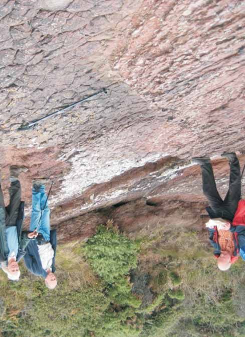
07
                                                                                            Contents

                    Where did we go?                                          2007 Field Visit Locations

                                                            Visit                                                                 Page

                                                            1. Quaternary features in the Barden Bridge
                                                               – Drebley area of Wharfedale                                        4

            Durham                                          2. Cadeby (Upper Permian) formation at Jackdaw Crag Quarry             7
           Permian /
          Quaternary                                        3. Visit to Coldstones Quarry and Trollers Gill                        9

                                                            4. Pendle Hill and Clitheroe                                           12

                                       Boulby Mine          5. Permian and Quaternary Geology of East Durham                       16
                                        Permian
                                                            6. “Sticking out like a sore thumb”..... a visit to Almscliffe Crag    21
   Anglesey                                                 7. Visit to Boulby Potash Mine                                         24
Pre-Cambrian
     to                                                     8. Residential Weekend on Anglesey                                     26
Carboniferous                            Quarry Tadcaster      - Friday 21st and Saturday 22nd September
                                            Permian            - Sunday 23rd September

                                                            Thanks to the authors of the field visit reports who also produced many of
                                            Wharfedale
                                                            the images: Neil Aitkenhead, Tony Benfield, Jon Brotchie, Judith Dawson,
                                            Quaternary
                                                            Howard Dunnill, Jeremy Freeman, Bob Gibson, David Holmes, Pauline
                                                            Sweet. Additional images provided by: David Peatfield, Judith Whalley.

                                                            Cover Picture: Holyhead Quartzite exposed close to axis of Rhoscolyn
                                                            Anticline. Holyhead Mountain, also exposing Holyhead Quartzite, just
                                                            visible on skyline (see visit report page 26)

Coldstones Quarry
   Trollers Gill
 Carboniferous
                                           Almscliff Crag
                         Pendle Hill      Carboniferous
                       Carboniferous                         Booklet designed and printed by Trendsetter Marketing Limited ☎ 01274 611222
                                                                                       www.trendsetteruk.co.uk

                               2                                                                   3
Quaternary features in the Barden Bridge-Drebley area of                            mudstone. The gravels were probably deposited in a vigorous glacial melt
Wharfedale.                                                                         water stream.
Sunday 13th May
                                                                                    Neil tentatively suggested an ice bound lake may have filled Firs Gill and the
                                                                                    eastern side of the Wharfe valley as the ice receded, whilst the main sub-
Leader : Dr. Neil Aitkenhead.                                                       glacial river was still forming the possible esker under the melting ice sheet. A
11 members attended                                                                 temporary colder interval may have shut off the supply of melt water. When
                                                                                    melting resumed, the main melt water river was forced by the ice to take a
Neil Aitkenhead took us to a stretch of Wharfedale he has been looking at           different course to the east of Haugh depositing its load of sand and gravel
recently, that has not been surveyed since J. R. Dakins, prior to the publication   over the top of the former lake deposits to form the Stangs Laithe feature.
of the 1889 geological map.
                                                                                    We made our way back to the cars along the unofficially-named Drebley
We made our way from the picturesque village of Drebley, perched on the             Gorge ,where the River Wharfe cuts a fine section to the west of Haugh
west side of Wharfedale, down to the valley floor. As we descended there was        through the Pendle Grit Formation. This is Pendelian (E1c) in age, the lowest
a good overview of the valley floor showing an arcuate line of small hills          sandstone formation in the Millstone Grit Group. It represents the first major
interpreted as a dissected esker. The typical narrow–crested symmetrical ridge      influx of coarse feldspathic sand of the Millstone Grit delta encroaching from
appearance is only seen towards the north-east end at its nearest point to          the north. The sandstones show the massive sharp-based beds characteristic
Drebley (see photo opposite). Elsewhere, parts of it have been removed by           of turbidites i.e. sand deposited out of suspension in turbidity currents that
erosion and those that remain have an asymmetric profile. This is because the       flowed down the pro-delta slope. Islands or stacks of very thick bedded
esker abuts against the lower western slope of the valley side so that the          massive coarse pebbly sandstone in the middle of the river probably
eastern side is steep, flanking the valley floor, whereas the western flank         represent deep channel fills.
mostly forms a terrace-like feature merging with the gentle valley slope.
                                                                                    A very pleasant and interesting day ended with an unseemly rush for our cars
Then we proceeded to parts of the flatter valley floor which Neil had               as the threatened rains arrived.
previously augured and found to be largely gravel. (This was confirmed by a
very sociable farmer who told us how quickly his land drained and the
problems taking a decent crop of hay). Closer inspection showed an
undulating surface 2.5m - 5m above the river level, the lower parts forming
hollows elongated down-valley, representing earlier braided river channels
formed in gravel (a braidplain or sandur).

Our attention now turned to possible Kame Deltas, flat topped mounds of
sand and gravel laid down in standing water at ice margins. We looked at two
flat topped hills and a dissected row of three hills all linked with other poor
exposures and all to the east of the esker. Excavations by rabbits revealed a
base of till covered by a coarse sandy layer a few metres thick and these were
overlaid by rounded to sub-rounded coarse gravels, cobbles and large stones
of limestone, sandstone, shale and chert a few metres thick.

One of the sites, the flat topped hill at Stangs Laithe, rewarded closer
inspection, the eastern side having been eroded by Fir Beck leaving an
excellent exposure. This showed 12.5m of finely interlaminated sand, clayey
sand, and silt which appeared to be horizontal indicating deposition in a
quiet body of water, probably a lake (see photo top of page 6). This
contrasted with the overlying 13m of coarse gravels mainly of rounded
limestone pebbles, but including cobbles and small boulders up to 60 cm in
diameter supported in a matrix of coarse sand. There were also some sub-
rounded to sub-angular clasts of coarse sandstone and calcareous shale or                  The line of the possible esker curving round to meet the valley side.

                                        4                                                                                    5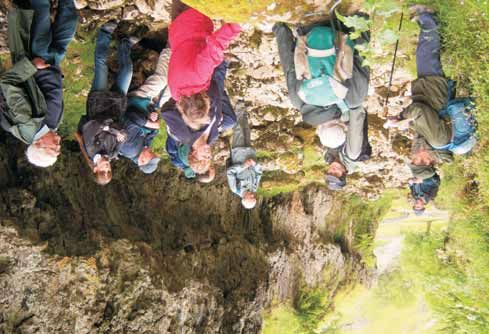
The Cadeby (Upper Permian) Formation at Jackdaw Crag
                                                                                   Quarry
                                                                                   Saturday morning 9th June

                                                                                   Leader: Tony Benfield

                                                                                   A party of 15 members and friends paid a short visit on a sunny Saturday
                                                                                   morning to Jackdaw Crag Quarry, some 2miles SW of Tadcaster. This quarry,
                                                                                   still working, is one of a number of sites exploiting that narrow band of
                                                                                   deposits of Upper Permian age running NNW from Nottingham towards
                                                                                   Catterick.

                                                                                   This quarry is an extensive enterprise, some 15 hectares (37 acres) in area,
                                                                                   excavated to a depth of at least 12-15m below the thin soiled, mainly drift-
                                                                                   free surrounding farmland. It consists of an older operation, now mainly
                                                                                   grassed over as a nature reserve, and the currently operating section which
                                                                                   the party visited first.

                                                                                   The rocks here, previously known as the Lower Magnesian Limestone, now
The exposure at the back of the flat-topped feature at Stangs Laithe showing the   called the Cadeby Formation, are shallow marine sediments accumulated
 horizontally interbedded sandstones, clayey sandstones and silts overlaid with    about 260Myr ago on the western margin of an unevenly subsiding basin
                             much coarser material.
                                                                                   within the ancient Laurasian continent which then extended as far as the
                                       6                                           present Baltic and Poland regions. At that time it lay much further South, at a
                                                                                   latitude of around 25 degrees north. Warm conditions favoured the
                                                                                   formation of carbonate deposits, sometimes sandy at the edges of the basin,
                                                                                   and evaporites later on towards the end of the Permian as sea levels fell.
                                                                                   Although brachiopods and bryozoa, indicating an active and oxygenated
                                                                                   environment, have been found in the Cadeby Formation near Durham, time
                                                                                   and safety considerations restricted opportunities for the party to try to
                                                                                   discover such things here.

                                                                                   The cream to brownish–yellow colouring of most of these limestones denotes
                                                                                   partial and not very uniform subsequent dolomitisation by very saline
                                                                                   magnesium-rich brines, as does the 2-3 cm diameter drusy cavities found in
                                                                                   some of the excavated material. These cavities, resulting from the density
                                                                                   increasing effect of the calcium to magnesium carbonate dolomitisation
                                                                                   reaction, have not prevented the use of Jackdaw Crag or 'Tadcaster' as a
                                                                                   building stone in York and Beverley Minsters, but the present output is
                                                                                   reduced on site for sale as crushed aggregate.

                                                                                   Structurally, at a safe distance from all newly disturbed surfaces, it was
                                                                                   possible when looking southwards to discern the expected regional dip of a
    The Cadeby Formation at Jackdaw Crag Quarry showing a normal fault
 with horizontal slickensides. INSET: Close up of the fault with slickensides.
                                       6                                                                                 7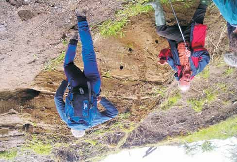
few degrees downwards to the east. On the western face there seems to be Visit to Coldstones Quarry and Trollers Gill
on the right a pink region, lacking a clear bedding structure, which is at a Saturday 23 June
higher level than its position on the left. This would suggest a normal fault
downthrowing to the south, contrary to the north-dipping fault which is
Leaders: Iain Burgess and Murray Mitchell
marked in this region on the 1951 G.S. Leeds 1 sheet. Unfortunately from our
14 members present, including the leaders, 1 visitor and Sheila
position no corresponding confirming feature could be seen on the east wall
Everett joined us for the afternoon.
of the excavation.
The purpose of the visit was to demonstrate a new interpretation of the
The floor of the working area was covered by a pale yellow fine limestone Lower Carboniferous Limestone stratigraphy in the area around Trollers Gill.
sand, fortunately dry for us, but most of the older abandoned area has been
grassed over as a nature reserve, the site being unsuitable for infilling The weather forecast was not promising and we were greeted with a heavy
purposes on hydrological grounds. A small part however had been used shower. The outlook worsened when it was pointed out that our first location
recently for stacking power station coal and was appropriately stained. Tony no longer existed! However, the day improved from then on - both
reminded us that the Coal Measures strata upon which the Permian lies weatherwise and geologically speaking - as arrangements had been made for
unconformably, is probably 50-70m. below our feet at this point due to the us to visit the quarry itself and this made for an extremely interesting day.
regional easterly dip.
The Quarry
The back wall of the old quarry is in the Sprotborough Member of the Cadeby The Manager, Sheila Everett, explained that the observation point had been
Formation, and shows large scale cross-stratification in approximately 8m. removed because the quarry was being extended, and told us about
sets which were formed from original sediments of an oolite lime-sand, now operations there. Iain then briefed us about the quarry's geological location
cemented and dolomitised. There were minor faults in some areas, one and the formations and structures which were visible.
particular example, seems to be a normal fault downthrowing by about 2m.
to the east, but showing a horizontally slickensided projecting surface, The quarry is located on the Askrigg Block near its southern edge. To the
apparently from a subsequent horizontal movement on the earlier fault south is the Craven Basin which was subsiding relative to the Block during
Carboniferous times. The lower part of the quarry exposes up to 80m of mid
plane (shown in photo bottom of page 6).
to pale grey limestone of Asbian age succeeded, unconformably, by the 21m-
thick, dark grey, Brigantian, Coldstones Limestone. Above are shales, capped
When sea levels fell towards the end of Cadeby Formation deposition, by the 40m+ thick Dirt Pot Grit. The Coldstones Limestone comprises the
consequent streams from the Carboniferous land areas to the west cut Hawes Limestone (18m, with the Girvanella Nodular Bed marked by a shale
channels in the Permian limestones, causing red staining due to percolation parting 10m above the base) overlain by the Gayle and Hardraw Scar
of iron rich solutions. Some lenses of red-brown siltstone seen in the quarry Limestones with a combined thickness of 3 metres (compared with around
wall might be attributed to transportation by these streams at flood times. 30m at Kettlewell).
Interestingly the small amount of drift deposit seen towards the east at the In the quarry the Dirt Pot Grit and shales have been recently stripped off a
top of the old quarry probably dates from the Anglian stage of the Middle new area for extraction to expose the limestone below. From a distance the
Pleistocene and not from the most recent glaciation as this location lies upper beds appeared to show wavy bedding and those below dipped away
from us in all directions, outlining the dome structure of the quarry itself (see
outside the Late Devension ice limit.
photo top of page 10). Sheila then took us over to walk on the wavy bedding
which proved to be huge, quite tight folds, with fractures where the dome
The visit was terminated at noon as arranged, with thanks to Tony for his fell away. We examined feeding traces in the limestone and other fossils
leadership, and to Darrington Lime, the quarry operators, for permitting which Murray identified, and also an exposed vein with the usual suite of
access and for supplying some protective clothing. Thanks also to what I minerals for the area.
was told were some peregrine falcons protesting loudly from trees at the top
end of the nature reserve, for deciding not to intervene. We spent a happy and fascinating couple of hours at the quarry before
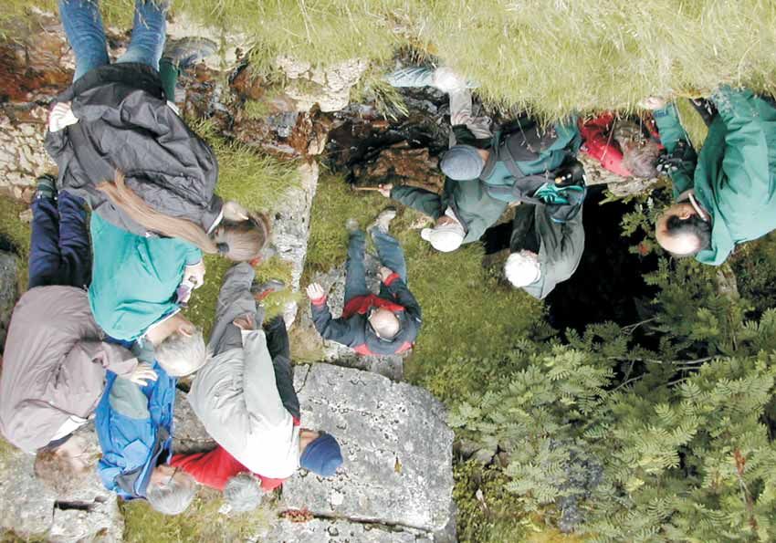
travelling the short distance south for lunch at Hell Hole above Trollers Gill.
8 9
Trollers Gill
                                                                            At Hell Hole, (see back cover), the Girvanella Band lies at the base of a 3
                                                                            metre exposure of limestone, above which is shale, with sandy limestone
                                                                            topping nearby hillocks. At the quarry there had been 11 metres of
                                                                            limestone above the Girvanella Band - overlain by shale, and the 40-metre
                                                                            thick Dirt Pot Grit. Where were the missing strata?

                                                                            Iain explained that an east-west trending, south facing escarpment, cutting
                                                                            through the Middle Limestone and underlying beds, was known to exist in
                                                                            the Grassington area, with Bowland Shales of Late Brigantian/Pendleian
                                                                            ages banked against it. The scarp was presumably created by a submarine
                                                                            landslip along the southern margin of the Askrigg Block, related to
                                                                            movement on one of the Craven faults. Iain suggested that here we were
                                                                            probably looking at the sole of the same landslip, which had cut off the
                                                                            upper part of the Coldstones Limestone and later beds, and that the
                                                                            overlying shales and limestones, presently correlated with the early
                                                                            Brigantian Yoredales, might instead have been deposited in a Basin
                                                                            environment and correlate with the Bowland Shales seen at Grassington.

                                                                            The Girvanella Band at Hell Hole was difficult to see after the earlier
                                                                            shower so we walked downhill to a narrowing of the track where the
                                                                            lowest 10m of the Coldstones Limestone are exposed. Here, Murray
                                                                            identified brachiopods and corals, particularly from a 70cm-thick shell bed,
On the top of the wavy bedding - with fractures where the dome falls away   4m below the Girvanella Band. This shell bed forms a well marked feature,
                                                                            which was traced along the hillside to above Gill Head Mine.

                                                                            Further downhill, at the bottom of Trollers Gill, we saw Asbian limestones
                                                                            typical of a back reef environment: intensely bioturbated by worms and
                                                                            other fauna in a nutrient-rich, protected environment, so bioturbated that
                                                                            bedding planes die out after a few metres. These limestones showed
                                                                            strong sub-vertical jointing.

                                                                            Walking up the narrow gorge with its curving overhangs, Iain gave two
                                                                            alternative theories of its formation (see photo bottom of page 10). The
                                                                            first is that it was a vadose channel which was exposed when the roof
                                                                            collapsed; the second that it is a tunnel cut by a stream flowing under an
                                                                            ice sheet where the hydrostatic pressure would be high, which
                                                                            subsequently collapsed His own view was that it was probably a
                                                                            combination and he pointed out the large sandstone erratics in the stream
                                                                            bed.

                                                                            We then walked up the gill to where the Coldstones Limestone crossed the
                                                                            beck. Beyond the ladder stile on the west bank, the shell bed reappeared
                                                                            and 4 metres above was a small exposure of the Girvanella Band in the
                                                                            path. We all had a good look and whilst the samples from the exposure
                                                                            itself were poor, one of our party found a nice piece in the gully below.

                                                                            All in all a really excellent field trip with an informative commentary and
                 In Troller's Gill - discussing its formation               handout - and it stayed dry the whole time.

                                     10                                                                          11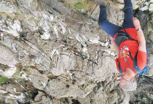
Pendle Hill and Clitheroe                                                        major river system from the north-west. The sands were first deposited from
Saturday 7th July                                                                suspension in channels on the basin floor, followed by the advance of the
                                                                                 delta front across the basin. Large channels were cut across and refilled by
                                                                                 smaller ones.
Leader: Paul Kabrna
14 Members present
                                                                                 The Pendle Grit which outcrops at the Nick O' Pendle is the type locality at
Our group met at the Nick O'Pendle on Pendle Hill under threatening skies to     Pendle Hill and also the oldest member of the Millstone Grit Group. Here the
examine exposures in the Pendle Grit Formation in this immediate vicinity.       basin-fill fan sequence shows various turbidite, mass flow and channel
Later in the day we would examine limestone deposits bordering the A59           features. We examined exposures at three small quarries close to the parking
Clitheroe by-pass and on the Salthill Quarry Geology Trail.                      area at the Nick O'Pendle; although named gritstone, these are fine to
                                                                                 medium grade micaceous sandstones with no crossbedding. In the small
                                                                                 North Quarry we looked at examples of high amplitude wavy bedding and
Our leader, Paul Kabrna, introduced the day with an overview of the geology      mud laminations – good evidence of their deep water turbidity current origin
of the area from this splendid vantage point. This covered a brief history of    – and loadcasts. Wavy bedding and mud laminations were more obvious in
the development of the Craven Basin as a NE – SW trending asymmetric half        the quarry adjacent to the parking area (see photo below). Inconsistencies
graben resulting from fault controlled extension of the earth's crust in late    between dip and features in these quarries show that inter-relationships are
Devonian – Tournaisian times. The basin's northwest margin is bounded by         complicated with faulting making it difficult to relate between exposures.
the Southern Lake District High and the northeast margin by the Askrigg
Block (which was controlled by the Middle Craven Fault) with the Central         Returning from Pendle Hill towards Clitheroe, we visited exposures in the
Lancashire High (CLH) to the southeast. This southern boundary of the CLH        highly fossiliferous Peach Quarry Limestone in the road cutting along the
coincides with the line of the Pendle Monocline. The depositional history of     A59. This is the type locality for these largely storm generated limestones. We
the basin is believed to have resulted from a combination of syndepositional
tectonics and eustatic processes. Consequently, the basinal sediments portray
a transition from carbonate shelf to slope. Within the basin no pre-
Carboniferous rocks are known.

Early deposits were Lower Carboniferous limestones on a gently dipping
ramp in shallow tropical seas. As basin subsidence outpaced deposition the
depositional slope steepened marking the transition to deep-water hemi-
pelagic sediments with limestone turbidites being fed from surrounding
carbonate shelves and platforms. Intermittent supply of terrigenous sand
into the basin is related to the emergence and erosion of the surrounding
area. Differential subsidence affected bathymetry, resulting in the deposition
of the Clitheroe Limestone Formation. Around Clitheroe the sea became
sufficiently deep for Waulsortian mud-mounds to grow (see below). There
was a shallowing event following the first period of Waulsortian production
which is marked by shallow-water, storm generated carbonates of the Peach
Quarry Limestone (seen in the A59 road cutting). Waulsortian Limestone
(Bellman Limestone in Salthill Quarry) deposition resumed marking a return
to deeper water conditions.

 Deposition of the Bowland Shale Group (late Asbian to Pendleian) is marked
by a reduced carbonate supply to the basin and an increase in oxygen
starvation of the basin floor which resulted in an accumulation of organic-
rich shales. In the Namurian, the Pendle Grit Formation is characterised by a
huge influx of coarse feldspathic sand deposited by turbidity currents from a       Examining wavy bedding and mud laminations in Pendle Grit turbidites in a
                                                                                                         quarry at the Nick O'Pendle

                                     12                                                                                13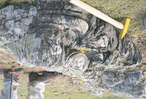
examined exposures dipping to the south at about 25 degrees, the typical dip
in this area, and noted an abundance of brachiopod and crinoid debris. These
were originally deposited close to the basin shore in shallow tropical seas in
the early Carboniferous.

The afternoon was spent following the Salthill Quarry Geology Trail, a series
of exposures surrounding a now disused limestone quarry. Even though the
old quarry floor is now commercialised, key geological features of Salthill
Quarry are preserved in the form of Waulsortian mud mounds. This quarry is
also one of the most important localities for Lower Carboniferous
echinoderms in northwest England with crinoids being the dominant fauna.
The site is the subject of a Geologists' Association Guide (see reference below)
and the whole site is an SSSI.

Waulsortian mud-mounds are very rare seabed limestone mounds, named
after the town in Belgium which is a classic area for their study. This quarry
complex exposes the unconformity at the Tournaisian/Viséan boundary.
There is a wide diversity of carbonate facies draped over eroded Waulsortian
mud-mounds, showing dramatic lateral facies change and palaeoslopes.
Various biofacies are represented as the sea deepened and the carbonate
regime was replaced by black shales. Salthill is in the middle of a series of
mounds from Clitheroe (the Norman Keep is built on a mud-mound)                      Section of Waulsortian Mud-mound showing unconformity between the mound
stretching over several kilometres to Gerna Hill to the east. They are the            and the overlying Visean limestones. Salthill Quarry Geology Trail - Clitheroe
opposite of normal limestone sea mounds (reefs formed in shallow water and
containing abundant fossils) in that they form in deeper water, have no            mounds than on the ridges.
bedding planes and contain very few fossils; they are also unusual in being
very light grey in colour. Mud-mounds formed during the time period in the         Basin conditions were ideal for many organisms to thrive, as their fossilised
Dinantian when the basin was sinking; there is evidence of three periods in        remains make up the bulk of the rock. This wealth of evidence enables
the Tournaisian and Viséan when conditions, and especially sea depth, was          palaeontologists to establish how these animals lived and also relationships
conducive to their formation. Basically they were just a mound of micrite          that existed between them. Crinoids were particularly abundant, with over
(lime mud) formed at depths from 130 to 300 metres, below the level to which       35 species identified at this locality.
light penetrates (aphotic conditions). The mud is mainly generated in situ and
the mounds had steep sides, up to 50 degrees, which is explained by bacteria       Salthill is one of those places where the fossil hunt of a field visit more than
acting as the agent for growth and also as a binding agent. As mounds grew         lives up to expectations, and the total enthusiasm of our leader for his subject
up to 200 metres in height towards shallower water, their characteristics          really inspired the group, some of whom have returned since for further
changing with water depth, and once photic conditions are reached, growth          exploration (and fossil hunting). The GA Guide referred to below provides a
of algae was possible. With the basin deepening, and eustatic sea level            comprehensive description of the geological background and locations on
changes, characteristics through a mound can change from those typical of          the trail, and is recommended.
deeper water to those of shallower water - or vice versa.
                                                                                   Reference:
The top of the mound at Salthill (see photo opposite) shows evidence of an         Bowden, A, Webster, M and Mitcham, T. (1997) Salthill Quarry Geology Trail
unconformity, when a shallowing event at end of the Tournaisian resulted in        Geologists' Association Guide No. 58. Available through the GA website or
submarine erosion, crumbling of the top of the mound and deterioration into        from Clitheroe museum (currently undergoing major redevelopment work).
a mass of rubble and boulders. This now marks the unconformity between
the mound and overlying Viséan limestones, which are dark grey, coarse-
grained, and rich in crinoids. The overlying beds are thicker between the

                                      14                                                                                   15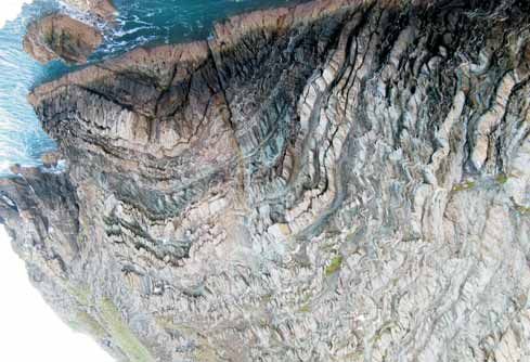
Permian and Quaternary Geology of East Durham                                     broad ENE trending ridges. During the Zechstein transgression the top few
Sunday 29th July                                                                  centimetres of Yellow Sand were reworked and locally contain burrows with
                                                                                  the brachiopod Lingula.

Leader: Dr. Eric Johnson                             Horridonia                   The sands are overlain by the Marl Slate Fm, a dark grey coloured organic rich,
11 Members present                                                                finely laminated silty shale deposited on the sea floor in conditions of anoxia.
                                                                                  This Formation dies out westwards towards the Zechstein shoreline. It is
Aim: To look at the Late Permian Zechstein Group Stratigraphy and follow the      usually less than 1m thick but locally it is thinned and thickened by
lateral transition from back reef lagoonal facies into reef limestone; a shore    syndepositional slumping and hosts the superb remains of fossilised fish.
to deep water progression.
                                                                                  In the quarry and a few other locations in South Durham the Marl Slate is
Although perhaps not quite as warm as Permian times, glorious mid-morning         succeeded by thinly bedded blue limestone (calcite mudstones and
sunshine and warm temperatures greeted 11 enthusiastic members led by an          wackestone). The limestones pass vertically and laterally into the more
upbeat Dr. Eric Johnson.                                                          familiar pale buff coloured Magnesian Limestone of the Raisby Formation.
                                                                                  Bioturbation is apparent in a hand specimen shown by the mottled
The first stop of the day was Tarmac's Coxhoe Quarry, formerly Raisby Quarry.     appearance of dark and pale patches (see photo 1 centre pages). A sparse
At the south side of the quarry we reviewed the plate tectonic setting of late    range of marine invertebrates are found in the lower beds of this facies
Carboniferous to early Permian times. Pangea was assembling and what was          including bivalves and the brachiopod Horridonia horrida. This unusual
to become Britain became landlocked in the centre of the supercontinent in        brachiopod was not attached to the sea-floor with a pedicle stalk but
the northern hemisphere close to the equator. Oceanic climatic influences         developed spines as a way of anchoring itself onto the soft sediment. The
were lost and arid desert conditions prevailed for the next 100Myr                Raisby Fm is interpreted as a basin slope deposit laid down on a 2-3 degree
throughout the Permian and Triassic.                                              slope in fully marine conditions of normal salinity.

During the late Permian, anticlockwise rotation of Pangea moved Britain           The next stratigraphically higher beds are the Ford Fm and were viewed in the
northwards to around 25°N causing extension and thinning of the                   abandoned Trimdon Grange Quarry which revealed a change in facies. The
continental crust opening up an intracontinental basin (Zechstein). During        weak cross bedded packstone/grainstone with ooids and pisoids and sparse
periods of high level sea stand a narrow channel and main barrier connecting      shelly fauna are interpreted as being deposited in a back reef protected shelf
this basin with the Boreal Ocean to the North was breached during                 and lagoonal setting (see photo 2 centre pages).
spectacular flooding events, allowing sea water incursion into the basin. At
times the link was periodically cut-off and high rates of evaporation ensued.     The third stop of the day was a brief visit to the Kelloe Meltwater Channel.
The five flooding and evaporation events recognised in the Upper Permian          The valley was carved through the Ford Fm and underlying Raisby Fm during
are thought to be the result of glacio-eustatic sea level variation.              the Late Devensian and forms part of a subglacial dendritic drainage system
                                                                                  on the western edge of the Permian limestone escarpment. The wasting and
In East Durham superficial drift of Late Devensian age mantles most of the        retreat of ice after the last glacial maximum provided the meltwater for
bedrock limiting exposure to the western edge of the limestone escarpment         eastward draining rivers to cut steep sided gorges through the glacial
and the deeply incised glacial meltwater valleys known locally as denes. The      succession into the underlying Permian rocks.
rocks encountered are dolomitic limestones of Upper Permian age 264-
260Myr at the base of the first evaporate cycle (EZ1).                            The fourth stop was to the largest of the meltwater channels, Castle Eden
                                                                                  Dene some 5.5 km long, 0.2-0.8 km wide and up to 60 metres deep. The dene
The quarry does not expose the plane of unconformity or underlying middle         preserves the largest area of semi natural woodland in northeast England
coal measures. The working face, to the east, displays an ordered stratiform      and typical of the wildwood that once covered most of Britain. A misfit
arrangement of Permian beds, (see diagram C centre pages), beginning with         stream meanders gently along the bottom of the gorge. The lateral transition
a 0-6m Basal Permian Yellow Sand unit exposed in the bottom of the quarry.        from bedded back reef limestones into a more massive reef facies in the Ford
This was initially lain down as large scale aeolian desert dunes (draa) forming   Formation was seen in the sides of the dene with a fauna of brachiopods,

                                      16                                                                                17
WEST                                                                                                                                                                        EAST
        COXHOE QUARRY (NZ338352)                                  TRIMDON GRANGE QUARRY (NZ362353)                                      CASTLE EDEN DENE (NZ428393)
                                               PHOTO 1                                                      PHOTO 2                                                       PHOTO 3

                FORD Fm
                                                                                                       FORD Fm
                                                                       Weak Cross beddedpackstone/grainstone
                                                                      Ooidal and Pisoidal wth sparse shelly fauna

      RAISBY Fm
      BEDDED
                                                                                                                                                                      FORD Fm
                                        10mm
                                                                                                                                           Lateral passage from bedded back reef
                                                                                                                                        limestones into more massive reef facies.
                                                                                                                                            Shells and Bryozoans more prevalent

                                                                                                                                         BLACKHALL ROCKS (NZ470392)
                                 Bioturbation in Blue
                                      Limestone                                                                                                                           PHOTO 4
                                                                                                                           10mm
                     MELTWATER
                     CHANNEL
                     KELLOE

                                                         50m
       A1M

                                                                                                                      Algal Laminate
                                                                1km
                                                         0

                                                                                                                 HARTLEPOOL
                                                                                  Base of Dene
                                                                                                   REEF          ANHYDRITE                             FORD Fm Intertidal Algal
               FORD Fm
                                                                                                   BIOSTROME                               Laminates grew on top of Barrier Reef
               Back Reef protected shelf & lagoonal setting

               RAISBY Fm                                                                                                               PHOTO 5
EZ1
               Deposition at the margin of a 2-3° basin slope
               BASAL YELLOW SANDS
               Large scale aeolian desert dunes                                              MARL SLATE Fm
                                                                                             Anoxic sea floor conditions
             UNCONFORMITY
               CARBONIFEROUS MIDDLE COAL MEASURES
                                                                                                                                                           FORD Fm Basal Breccia
Diagram C - Cross section showing transition from back reef lagoonal facies into reef                                                      Submarine slumping of material down
formations of Late Permian age (Zechstein EZ1) in East Durham
                                                            m.                                                                           the front of the reef on the seaward side
bivalves, and bryozoa but few corals (see photo 3 centre pages). “Sticking out like a sore thumb”…a visit to Almscliff Crag
Thursday evening 12th July
The final stop for the day was at Blackhall Rocks. The raised beach there
consists mostly of Coal Measures ironstone nodules and sandstone derived Leader: Professor Paul Wignall
from colliery waste that was formerly dumped into the sea. These provide a 27 members present
reminder of the once thriving mining industry that exploited the offshore
coal reserves. Many geologists, (including Gilligan (1920), and Versey (1948)), have offered
explanations as to the “how” and “why” of this topographic anomaly: a
The coastal outcrop exposes the uppermost part of the Ford Fm reef facies blocky crag poking up, with a “contrary” tilt, on a long and otherwise smooth
known as the Heselden Dene Stromatolite Biostrome. Two distinctive rock grassy ridge! Twenty-seven LGA members, equally curious, circumnavigated
types are present in the biostrome. At the base there is a boulder breccia the Crag with Professor Paul Wignall on a cloudy evening in July, to see
formed by rock debris that broke off and fell down the steep seaward side of evidence for the more recent interpretations of Ian Chisholm (1981) and Andy
the reef . This is overlain by a thick unit of algal laminates (stromatolites) Sims (1989); though Paul emphasized that even these explanations leave
which grew within the intertidal zone on top of the reef (see photo 4 & 5 questions unanswered.
centre pages). The familiar domed structure is clearly visible on a large scale Almscliff Crag is formed by the Namurian coarse-grained channel-deposit of
where multiple generations of algae built up the sequence. what was a vast south-west flowing river, at, or near, its deltaic limit on to the
shales of the south-eastern side of the Craven Basin; and previous accounts
Southwards the coastal section reveals younger parts of the Permian have noted faults, measured palaeo-currents, suggested “slumping” and
succession but sadly closing rain and lack of time brought the day to an end. diagnosed unusual cementation in this feature.
Our appreciation and thanks were offered to Eric for his superbly led field
visit. But following Chisholm we examined an overhanging south-westerly-
dipping rock-wall, (See photo opposite), noting the shallow grooves at its
base. Chisholm identified this wall as a low-angled listric fault surface, and
the grooves as “soft-sediment slickensides,” the result of uncemented sands
slipping past each other during movement on the fracture (See photo
opposite (inset)). This rotational fault, (now largely in the air, thanks to
erosion), which is postulated to bound the curving north-east side of the crag,
is significant in several ways:
• It is a syn-depositional structure affecting only the lower part of the
sandstone…we saw no evidence of this fault in the top 10 metres of the crag.
• It is a “growth-fault,” which was down-throwing continuously, (or in
pulses), during the earlier stages of deposition….possibly on a steep-fronted
upper delta-slope. This built a “fan” of dense sand-wedge sediments, which
are dipping northwards in to the fault surface, on top of less dense and
unstable lower siltstones (See Diagram A page 22). This process convincingly
accounts for the additional 35 metre local thickening of this sandbody, (as
measured by Chisholm), for around 150 metres along the strike at this
location, and, perhaps, helps to explain its relative resistance to erosion.
• Such a fault also gives grounds for the changes in dip seen on the Crag,
from the gentle (17° to 20°) south-south-easterly (tectonic) dip of the
Millstone Grit succession around the Crag and across the Wharfe valley, to the
LGA Members surveying an exposure of the low-angled fault surface
steeper (22° to 29°) north-easterly dipping bedding-planes in the NE corner of
INSET: Examples of some of the soft-sediment slickensides at the base of the the outcrop. Moreover, (see Diagram A page 22) this process is also reflected
fault-wall (red pencil in rock pocket mid-right, for scale)
20 21in the south-westerly palaeocurrent measured for these cross-bedded “dip-fan”, and we took many photographs (See photo below). This really
foresets (See also Diagram B below). showed us the growth-fault in action!
Sims, too, found evidence of a series of similarly-formed minor faults “which On another small face we could see more evidence of subsidiary growth-
developed sequentially away from the major fault as new faults formed so faults occurring well before cementation, since movement seems to have
the earlier faults became inactive and were rotated passively by continuing involved “grain-rolling, in zones up to 5cm wide, rather than grain
movement on the major fault….a progressive kinematic wave.” * Many of us breakage”*.
scrambled up to a small face showing clear evidence of just such a small–scale
However, as Professor Wignall pointed out, even this interpretation has its
problems, growth-faults are rare anywhere in the Millstone Grit and typically
develop on an upper delta-slope. But the Almscliff Grit is a truly fluvial
sandstone, (with confirming evidence of mudflake-clasts and tree-fossil
remains at this location). Perhaps the transition from river-channel to delta-
top to basin happened really abruptly here… a scenario supported by the
absence of all traces of the Almscliff Grit in a bore-hole a mere 4km to the
south of the Crag!
What further explanation of this intriguing feature shall we hear on our next
visit?
*from “The Geology of Almscliff Crag, Wharfe Valley, North Yorkshire,” Field
Visit notes by Professor Paul Wignall.
Rock face showing evidence of the build up of the dip-fan adjacent to a minor
growth fault
22 23Visit to Boulby Potash Mine bolting to a depth of 2m. to stabilise the roof. The pillars are brittle and
Wednesday 5th September unstable with fragmented pieces, both small and large, breaking off and
creating a potential hazard to miners. When extraction from a gallery is
completed, the workings are left to collapse and close over time. The mining
Cleveland Potash Representative : Neil Rowley operation is a repeated sequence of extraction over a given distance,
6 members present followed by bolting of the central roof, then forward (and upward) drilling to
assess the disposition of deposits to guide the ongoing extraction operation.
Boulby Potash Mine, operated by Cleveland Potash, is located 2km. west of
Staithes, close to a NW – SE trending section of the coast, and extracts the The mining machines (4 for potash and 2 for salt) are each operated by a
potash ore Sylvite, mainly potassium chloride, from the salt deposits formed miner from a remote control handset. Each machine rips out ore, gathers the
in the Upper Permian (260-250Myr) as a result of evaporation at the periphery material and feeds it back onto a mobile shuttle platform which carries a 20
of the Zechstein Sea. Visits are now restricted to a group of 6 who can tonne batch to the conveyor. There is some crushing of larger pieces at the
conveniently be transported underground to the ore extraction area by Land feed onto the conveyor. Product is raised to the surface up the main shaft in
Rover. 23 tonne loads, 2 hoppers rising and descending alternately to deliver a load
from 1100m depth every 3 minutes.
Since extraction and processing commenced in 1973, the production level has
risen steadily through various productivity improvements to a total ore and In a further processing plant, potash is separated from sodium chloride
salt extraction currently of about 4 million tonnes per annum, yielding about through a foam flotation process. The ore is finely crushed and a saturated
1 million tpa. of potash for fertilizer and also a substantial quantity of salt solution used as the medium to float KCl particles in the foam away from
common salt for road de-icing as a by-product. NaCl. It is then scooped off and dried. Large quantities of sea water are taken
in for the separation process, and returned to the sea as concentrated brine,
Following a presentation on the history and aspects of current operation of feeding up to 1 million tonnes of sodium chloride into the North Sea per
the site, our group changed into protective clothing, lamps and safety gear annum.
for the mine visit (see photo opposite). There are 2 shafts to a depth of 1100
metres, one for personnel and one to lift product to the surface and for other
heavy duty work. Over 34 years of operation, workings have extended some 7
miles to the north, mostly under the North Sea, and about 4 miles to the
south. As the salt bearing strata dip at about 3 degrees to the SE, this results in
a current working depth of about 800m. and an ambient temperature of 35
degrees C. at the northern end of the workings; at the southern end, the
depth reached is 1300m. and ambient temperature of 45 degrees C. We were
relieved to be viewing the northern operation, which was quite warm
enough!
Main roads throughout the mine are driven through the lower halite deposits
which are much more structurally stable over a long period, with roadways up
ramps into extraction galleries in the overlying potash rich deposits. [Sylvite
ore is 38-40% potassium chloride, 45-50% sodium chloride, 10-15%
insolubles (clay minerals)]. All roadways in the mine are twinned with forced
circulation in along the vehicle tunnel, air returning along the conveyor
tunnel carrying potash ore to the main shaft.
Extraction galleries in the potash are up to 1 km. in length, with a width of
about 55m; a central working tunnel is created with extraction to both sides
leaving pillars, all to a height of about 3m. About 2 m of potash ore is left
above the workings for stability as the marl deposits overlying the potash are
very unstable. The roof of the central tunnel is strengthened by drilling and Boulby Mining Party
24 25Residential Weekend based at Cemaes Bay, Anglesey
Friday 21st to Sunday 23rd September
Leader: Dr Allan Brandon
26 members and spouses
Friday 21st September.
During the afternoon, members gathered at the Gadlys Hotel, Cemaes, on
the north coast of Anglesey. Early arrivals were given details of Excursion 3
(G.A. Anglesey guide) and some went for a first look at the local geology.
After an excellent dinner, the leader gave a brief introduction to the geology
of Anglesey, controversial since the first comprehensive account given by
E.Greenly, 1919. The succession ranges from beds until recently considered
Pre-Cambrian, and making up more than half the island, through to
Carboniferous. Recent work indicates that the lowest “Pre-Cambrian”
sediments of the Mona Supergroup are at least partly late Cambrian and/or
early Ordovician. Intense glaciation moving NW to SE, and coincidentally
along the predominant grain of the solid geology, gouged out softer
Sea cliffs exposing folded South Stack Formation, South Stack, Holy Island.
sediments and left a largely subdued topography that has been enhanced by The prominent bed towards the foot of the cliff is estimated to about 1.5m thick
marine peneplation.
wavelength perhaps 30-40m, slightly tilted towards the south. Small-scale
Saturday 22nd September. folding superimposed on this has resulted in complex distortions of the less
competent mudstones and quartz veins but has hardly affected the thickest
On a fine sunny morning, members set off at 9.15 am for South Stack, Holy greywackes. As the party started the slow climb back to the cars, the bridge
Island, noting en route the featureless and windswept topography. The was opened and several members crossed to get better views of the cliff face.
leader summarised the succession of the Mona Supergroup, thought to be 5-7
km thick, comprising the South Stack Group exposed along the coast of Holy Before we drove off, attention was drawn to rock surfaces near the path
Island, the New Harbour Group (not visited) and the Gwna Group, see below. polished by glacial action, on which glacial striae were seen trending roughly
The South Stack Formation, the lowest part of the group, comprises lightly NNE-SSW (see photo top of page 28).
metamorphosed greywackes and mudstones, considered to be turbidites
derived from a continent to the SE. They have undergone Caledonian The party drove a few kms SE to Rhoscolyn Church. In this area, beds of the
compression and developed well-marked cleavage; no shelly fossils have ever South Stack Group form an important local feature, the Rhoscolyn Anticline.
been discovered. At South Stack they form spectacular sea cliffs, (see photo Its core was seen in grassy fields some 500m SSW of the church in the form of a
opposite), running roughly N-S and some 50m high, facilitating views of the low smooth ridge exposing the Holyhead Quartzite, immediately overlying
Wicklow Mountains to the west. the South Stack Formation. (See front cover). This clean metamorphosed
sandstone originated as marine sands reworked into deeper waters. The
Members walked down the zigzag flight of 400+ steps to the lighthouse anticlinal axis strikes NNW-SSE and plunges to the NNW. On the crest of the
bridge. From the path members had excellent views of the contorted beds, ridge there is a plaque in memory of Prof. Dennis Wood, noted for his
with alternate bands of greywacke, typically about 1 m thick, and mudstone enthusiasm for the local geology. Some of the party braved thickets of gorse
with bands of white quartzite, perhaps developed along bedding planes on to examine another exposure in a small quarry nearby, where thin white
dewatering. The beds formed a series of not quite symmetric folds, of quartz veins were seen along vertical joints and some vestiges of normal and
26 27of current bedding were eventually discerned on one of the joint faces. The
party then moved seaward, en route visiting another small quarry where a
search for signs of bedding proved fruitless.
In the very rugged cliff top the South Stack Formation was exposed and
members scrambled amongst the rocks examining the extreme deformation.
Here the large scale folding seen at South Stack was not obvious but the
thinner beds showed intense folding on various smaller scales, (see photo
bottom page 28), often overturned towards the SE, opposite to what would
be formed if slumping had affected sediments arriving from the SE. Some
searching was needed before dewatering structures were found in some of
the coarser beds (see photo below).
Lunch was taken by the cliff top then, returning to the cars, we passed two
deep narrow inlets formed along minor faults roughly parallel to the axis of
the anticline and revealing larger scale folding roughly perpendicular to the
axis of the Rhoscolyn Anticline.
The party then drove to Newborough Warren, near the southern corner of
Anglesey, to see spilitic lavas forming part of the Gwna Group exposed on
South Stack Formation greywacke with glacial striae (parallel to pencil)
Llanddwyn Island. Pebbles noticed during a walk of about 1 km along the
trending NNE-SSW beach included fragments of dull purple-red jasper derived from the spilites.
Folds in South Stack Formation overturned to SE, Dewatering structures, cliff top Rhoscolyn
seen in cliff top Rhoscolyn, Holy Island
28 29On the spit joining the island to Anglesey, several rocky mounds stood out Sunday 23rd September
from the sand (see photo below). These consisted of particularly well-
developed pillow lavas, with individual pillows ranging from less than 0.5 to Parys Mountain Copper Mine
over 2 m wide. Pillow form indicated younging to the SE and overturned
strata. Patches of dull red jasper and limestone were seen in the pillow The early morning rain had fortunately stopped by the time our party
interstices. On the landward edge of the island an outcrop showed pillow assembled at Parys Mountain. Here a short walk from a car park took us to a
lavas overlying agglomerate. view point overlooking an enormous open pit estimated to be about 300m
long, 100m wide and about 40m deep, where a very rich copper bearing lode
The party returned along the beach and drove back to Cemaes. Those that had been extracted. This pit was excavated mainly between 1768 and the
had not done so on Friday drove a further km north and walked onto a small early 1800's by which time mining was largely underground.
headland immediately west of Llanbadrig Church, formed by the Gwna
Melange. This is a spectacular complex of huge blocks of assorted rock types, At the viewpoint, many of our group commented on the huge size of the pit
also present, but not visited, on Llanddwyn Island. It is supposed to have been and on how unexpectedly colourful it was (see photo below). Not only was
formed by an underwater rock slide on a catastrophic scale. Here, the there much yellow and orange-brown, contrasting with the blue-grey of the
outcrop mainly comprised huge slabs of more or less dolomitised limestone, slaty mud rocks, but also a conspicuous absence of the blues and greens that
some brown and much weathered, some paler with beds of chert, dipping would be associated with copper mineralization. When we walked down
fairly steeply seaward. At one point we saw a mass of brecciated quartzite well-made paths to the bottom of the pit we found that the colours were
probably due to fine coatings of iron oxides or hydroxides. Close examination
some 2m thick. Returning to the cars, we passed across a large grassy hollow,
of an unworked pillar of rock in the centre of the pit showed it to be riddled
with weathered and shattered limestone exposed on the coast, which the with irregular veins containing an abundance of finely disseminated cubic
leader surmised might be part of a collapse structure in “Pre-Cambrian” crystals of iron pyrites. Somewhat disappointingly, this was the only metallic
limestone. The party then returned to the Gadlys Hotel, where another sulphide we could find.
excellent dinner was enjoyed.
Pillow lava, Gwna Group in spit at landward end of Llanddwyn Island Viewpoint, looking into Parys Mountain Copper Mine
30 31Perhaps the highlight of the visit was the discovery of graptolites in the scree Lligwy Bay
of cleaved slaty mudrocks (Central Shales) below a conspicuous face of this
lithology at the western end of the pit. One member pronounced himself to On Sunday afternoon we ascended the stratigraphic sequence of Anglesey
be “thrilled to bits” by this discovery, particularly because the graptolites and drove to Lligwy Bay on the NE coast to examine rocks of Upper Palaeozoic
were well preserved, their thecae having been replaced by pyrite, producing age. After lunch in a rather desolate carpark (where the toilets were firmly
three-dimensional preservation instead of the usual crushed forms. locked up for the winter!), we walked to the south side of the Bay to examine
However, because the cleavage was somewhat oblique to the original Lower Carboniferous strata. The first exposures were of limestones and
bedding surfaces we could only see short fragmentary lengths of single stipes mudstones with interbedded conglomerates which suggested that we were
on the cleavage surfaces. The Central Shales are said by Dr Jan Zalasiewicz close to the unconformable base of these Asbian and Brigantian age rocks.
(personal communication) to be of early Silurian (Llandovery) age. The conglomerates exhibited a variety of clast lithologies including large
blocks of dolomitised limestone and rounded pebbles of probable
The conspicuous face, referred to above, provided the main evidence for the Precambrian origin. At one point, the conglomerates were banked around an
tectonic structure of the rocks flanking the pit, for the axial hinge of a tight, upstanding block of limestone which originally had been interpreted as the
south-facing, synclinal overfold was clearly visible in this face (see photo base of a Dinantian sea stack surrounded by beach gravels. However, the
below). The north limb of this fold appeared to be vertical whereas the south conglomerates were more likely to be of fluvial origin.
limb is inclined at about 45° to the north. The presence of this fold suggests
that the pit as a whole was aligned along the axial part of this syncline. Poorly
Our Leader referred to the development of cycles within the Late Dinantian
exposed highly altered acid volcanic rocks stratigraphically underlying the
which resulted from contemporaneous sea level fluctuations, probably of
Central Shales were seen flanking the pit in places and showed some flow
glacio-eustatic origin. During periods of high sea level, limestones were laid
banding.
down; when sea level fell, the limestones were subaerially exposed and
suffered karstic weathering with the development of, for example, potholes.
Somewhat surprisingly for a place which has had, and may still have, great The overlying sandy mudstones represented palaeosols in part, but some
economic potential, the basic stratigraphy and structure of Parys Mountain, must have been deposited during the next sea level rise.
according to Dr Zalaseiwicz, is still not fully understood.
As we made our way along the base of the low cliffs, it became apparent that
the dips, which had been at a low angle to the SE, were beginning to increase.
In one roughly circular area they became almost vertical and the limestone
beds, one of which had a characteristic clotted appearance, broken (see
photo overleaf). Below and elsewhere, dips remained low to the SE. The
explanation for this phenomenon lay in the sea level fluctuations referred to
above. When sea level dropped, karstic weathering of the exposed
limestones had resulted in the development of a doline into which higher
strata had collapsed. Dr Brandon explained that the vertical extent of such a
collapse was indicated by the presence of a limestone with a characteristically
clotted lithology which occurred some tens of metres higher in the
succession.
After ascending the low cliffs, our scenically attractive walk took us to a point
where an ice scraped and striated erosion surface cut in Brigantian limestone
revealed large specimens of colonial corals, solitary rugose corals and some
productid brachiopods. Dr Brandon pointed out that the glacial striae
indicated that the ice which had deposited the overlying red, Trias-derived
till, had moved from NE to SW. Continuing to the east and updip, we reached
the outcrops of the clotted limestone at its normal position in the sequence.
Here it rested on sandy mudstones infilling hollows in the
Core of assymetrical syncline in Parys Mountain Copper Mine contemporaneously weathered top of the underlying limestone bed.
32 33Lligwy Bay, showing doline collapse structure with almost horizontal beds at far
right, slumped thick-bedded limestones in centre, and almost vertical thinly-bedded
clotted limestones on left
After walking back to the cars, most of the party drove to the north side of
Lligwy Bay, where we walked across the sands, and some of us approached a
notice with its back to the direction from which we had come, which warned
us of the danger of quick sands!! The beds here were the red beds of the
Lower Old Red Sandstone of either Late Silurian or early Devonian age.
The first exposures reached were of red fine-grained sandstones and
mudstones of the Traeth Lligwy Formation within which the red colour and
the presence of sporadic mud cracks testified to their origin in a probable
playa lake environment within an essentially arid region (see photo
opposite). The presence of trace fossils showed that such lakes were not
without life. The rocks were folded into a shallow syncline plunging to the
SE; cleavage developed in its axial region reminded us that these beds pre-
dated the peak of the Acadian Orogeny.
Walking to the north, we had just time to reach outcrops of the underlying
Porth-y-Mor Formation with its well-developed fluvial sequences of erosively
based channel and point-bar sandstones fining upwards into overbank
mudstones. At this point Howard Dunnill gathered the party together and
Mud cracks in Traeth Lligwy Formation, Old Red Sandstone, Lligwy Bay
thanked Dr Brandon most warmly for spending his week-end with us and for
introducing us so comprehensively to the varied and spectacular geology of
the Isle of Anglesey.
For more information visit us at:
34 www.leedsgeolassoc.freeserve.co.uk
32You can also read


