Level crossing collision between passenger train and road vehicle - Wynnum West, Queensland on 26 February 2021
←
→
Page content transcription
If your browser does not render page correctly, please read the page content below
Level crossing collision between
passenger train and road
vehicle
Wynnum West, Queensland on 26 February 2021

 ATSB Transport Safety Report (Defined)
 Rail Occurrence Investigation
 RO-2021-005
 Prelim - 5 August 2021
Released in accordance with section 25 of the Transport Safety Investigation Act 2003

Publishing information
Published by:            Australian Transport Safety Bureau
Postal address:          PO Box 967, Civic Square ACT 2608
Office:                  62 Northbourne Avenue Canberra, ACT 2601
Telephone:               1800 020 616, from overseas +61 2 6257 2463
                         Accident and incident notification: 1800 011 034 (24 hours)
Email:                   atsbinfo@atsb.gov.au
Website:                 www.atsb.gov.au

© Commonwealth of Australia 2021

Ownership of intellectual property rights in this publication
Unless otherwise noted, copyright (and any other intellectual property rights, if any) in this publication is owned by the
Commonwealth of Australia.

Creative Commons licence
With the exception of the Coat of Arms, ATSB logo, and photos and graphics in which a third party holds copyright,
this publication is licensed under a Creative Commons Attribution 3.0 Australia licence.

Creative Commons Attribution 3.0 Australia Licence is a standard form licence agreement that allows you to copy,
distribute, transmit and adapt this publication provided that you attribute the work.
The ATSB’s preference is that you attribute this publication (and any material sourced from it) using the following
wording: Source: Australian Transport Safety Bureau

Copyright in material obtained from other agencies, private individuals or organisations, belongs to those agencies,
individuals or organisations. Where you want to use their material you will need to contact them directly.

Addendum

    Page                Change                                                                          Date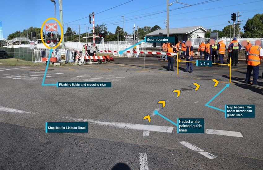
ATSB – RO-2021-005
Preliminary report
This preliminary report details factual information established in the investigation’s early evidence collection
phase and has been prepared to provide timely information to the industry and public. Preliminary reports
contain no analysis or findings, which will be detailed in the investigation’s final report. The information
contained in this preliminary report is released in accordance with section 25 of the Transport Safety
Investigation Act 2003.
The occurrence
At about 1340 on Friday 26 February 2021, a non-revenue express suburban train collided with a
road vehicle at Kianawah Road level crossing, adjacent to Lindum Station on the Cleveland line in
Wynnum West, a suburb of Brisbane, Queensland.
The road vehicle was a small 4-door hatchback (Hyundai i20). The driver was from the Sunshine
Coast and was visiting a friend in Brisbane. At about 1330, the driver left the friend’s address to
visit a location in Wynnum. The friend stated that the driver was unfamiliar with the area and the
level crossing and it was likely that they used a navigation system to assist with directions.
The hatchback travelled in an easterly direction along Lindum Road. At the T-intersection of
Lindum Road and North Road, the driver’s intention was to turn right and pass though the
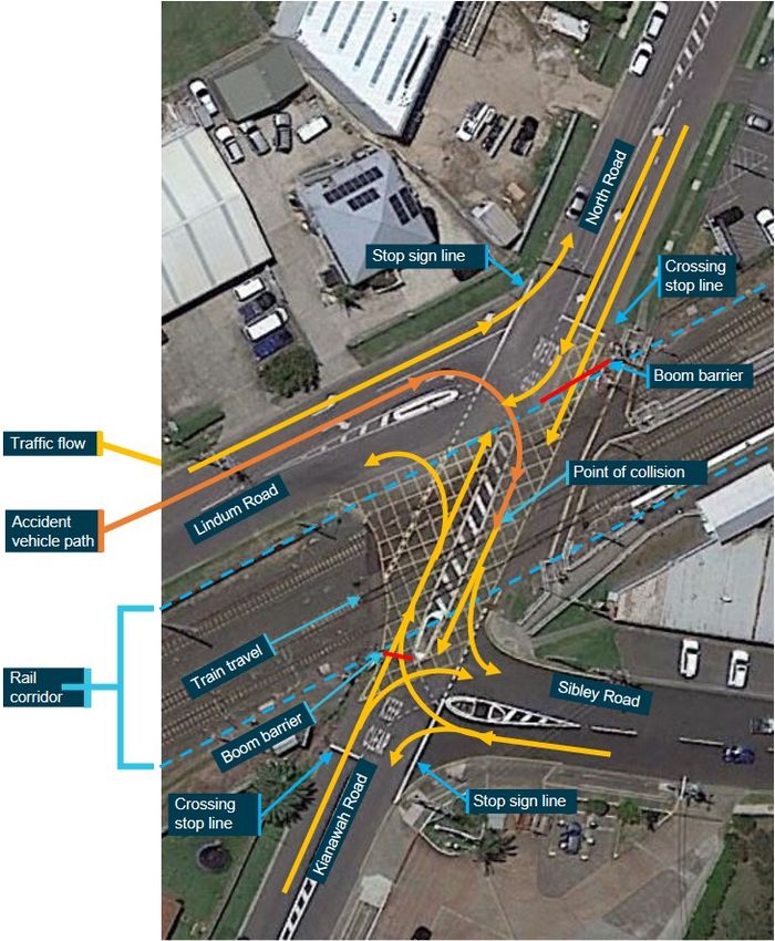
Kianawah Road level crossing en route to Wynnum (Figure 1).
Figure 1: Driver’s intended route from Lindum Road through the level crossing
Source: Google Earth, annotated by the ATSB
As the hatchback approached the Lindum Road–North Road intersection, there were two cars
waiting in a queue in the turn right lane. During a pause in traffic, the first of the two cars turned
right and passed through the level crossing. At that point in time, the express train, travelling in an
easterly direction towards Cleveland, automatically activated the level crossing protection on its
approach.
›1 ‹ATSB – RO-2021-005
As the second car ahead of the hatchback moved away from the ‘stop line’ to turn right, the
flashing lights on the opposite side of Lindum Road were operating, warning of the train’s
approach. As that car passed through the level crossing, the boom barriers were lowering.
After the second car moved away from the intersection, the driver of the hatchback moved forward
on Lindum Road and stopped at the intersection ‘stop line’. The driver delayed at the ‘stop line’ to
give way to another car that was travelling south along North Road. This car turned right into
Lindum Road in front of the hatchback. The driver then momentarily moved forward but came to a
sudden stop as another car (a utility vehicle) approached the intersection from the same direction.
The driver of the utility vehicle stated that, as they turned right into Lindum Road, they observed
the boom barrier was horizontal and saw a train approaching the level crossing. As they looked
through their rear-view mirrors, they noticed that the hatchback which had been stopped at
Lindum Road had moved off and was approaching the level crossing. They witnessed the car
pass onto the level crossing and collide with the train.
Evidence from station closed-circuit television (CCTV) footage showed that the hatchback passed
to the right of the boom barrier’s lowered arm, and to the left of the turn line from Lindum Road to
Kianawah Road. The hatchback was destroyed, and the sole occupant was fatally injured. The
train sustained minor damage and the only two occupants of the train, the driver and guard,
were not injured.
Context
Level crossing general information
The Office of the National Rail Safety Regulator (ONRSR) stated in its Rail Safety Report 2019–
2020:
There are more than 23,000 level crossings in Australia and at all of them there exists a level of risk to
safety – indeed, other than suicide and trespass, accidents at level crossings are the primary cause of
railway related fatalities among the general public.
There were 37 level crossing collisions between a freight train, passenger train or tram and a road
vehicle reported in the 2019–2020 financial year, the majority of which involved a freight train. More
than 60% of these collisions occurred at crossings protected by active control devices, such as bells,
lights and boom gates. There were three fatalities [from two accidents] and two serious injuries
reported as a result of these collisions, all affecting road vehicle occupants.
There were 6 level crossing collisions between a freight train, passenger train or tram and a person
reported in the 2019–2020 financial year, resulting in four serious injuries to members of the public.
Five of the six collisions took place at crossings protected by active control devices.
All rail safety stakeholders, including the general public, have a role to play in improving safety at level
crossings and ONRSR continues to advocate for co-operation between all parties that will ultimately
help reduce the rate of fatalities and serious injuries. ONRSR also continues to support the work being
done by governments and industry to remove level crossings and their commitment to a policy of no
new level crossings.
According to the Queensland Rail (QR) website:
In Queensland, there are over 1,200 level crossings that are connected to the road network. Level
crossing incidents carry a high risk of serious injury or death. That is why signs and signals are in
place to keep everyone safe. All level crossings have some form of protection including:
• Flashing lights
• Flashing lights and Boom gates
• Stop or Give Way signage
• pedestrian crossing gates
• warning signs…
›2 ‹ATSB – RO-2021-005
In the 2019-2020 financial year, Queensland Rail recorded seven collisions in Queensland. In
addition, there were 211 near miss incidents with 133 in South East Queensland (SEQ) and 78 in
regional areas.
Kianawah Road level crossing design
QR was the rail infrastructure manager for the Cleveland rail line (and the rest of the Brisbane
suburban rail network), including the rail infrastructure at the Kianawah Road level crossing. The
Brisbane City Council (BCC) was the road manager for the roads surrounding the Kianawah Road
level crossing.
The Kianawah Road level crossing is in Wynnum West, in the eastern suburbs of Brisbane.
Kianawah Road runs in a northerly direction up to the rail corridor, and North Road runs in a
southerly direction up to the rail corridor. Kianawah Road and North Road cross the rail corridor at
a 40° angle. The roadway is about 13 m wide with one lane in each direction and a painted
median island between the two lanes.
The level crossing had active control devices in place that were designed to control the movement
of vehicular and pedestrian traffic through the crossing. These devices included level crossing
flashing signals, boom barriers, and audible warning alerts. The devices were designed to activate
prior to and during the passage of a train through the level crossing.
There was no requirement for a road user approaching the crossing on Kianawah Road or North
Road to stop when the level crossing protections were not active. If the protections were active,
road users were required to stop at ‘stop lines’ painted on the road in front of the boom barriers
(Figure 2).
In the immediate area of the level crossing, there were two T-intersections, one on either side of
the crossing. On the northern side, Lindum Road connected with North Road, and on the southern
side, Sibley Road connected with Kianawah Road.
There was a stop sign on Lindum Road where it joined North Road, and a stop sign on Sibley
Road where it joined Kianawah Road. Traffic flow was such that a vehicle turning right from
Lindum Road to cross the level crossing (as was the case during the accident sequence) had to
stop and give way to traffic from both North Road and Kianawah Road (Figure 2).
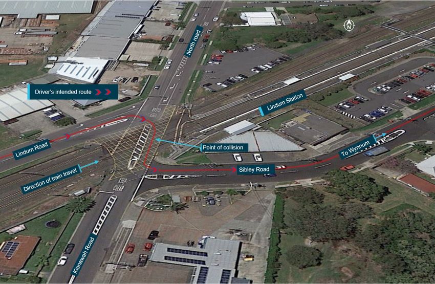
Figure 2 shows the Lindum Road and North Road intersection on the northern side of the level
crossing and the Kianawah Road and Sibley Road intersection on the southern side of the
crossing. Depicted in the image are the potential variations in road vehicle travel, the path of the
vehicle involved in the accident, the direction of the train’s travel and the point of the collision.
The position of the two boom barriers on North Road and Kianawah Road are also indicated in
Figure 2. The road surface was painted with yellow cross-hatched lines in the area between the
two boom barriers. Level crossing flashing signals were positioned on the northern side to face
road vehicle users approaching the crossing from North Road. There was also a set of flashing
lights positioned to face road users approaching the crossing from Lindum Road (Figure 3).
›3 ‹ATSB – RO-2021-005
Figure 2: Kianawah Road level crossing showing interconnecting T-intersections and
traffic flow
Source: Google earth, annotated by the ATSB
Boom barrier design
Australian Standard (AS) 1742.7 – Manual of uniform traffic control devices (Part 7: Railway
crossings) stated that:
Boom barriers shall comprise as a minimum, a boom extending from the left side of the roadway–
(a) to the right hand kerb or edge of a one-way roadway;
(b) to the edge of a median island; or
(c) in the case of a two-way roadway, to the dividing line or centre of the roadway if no line is marked.
The boom in its lowered state should be placed at right angles to the road centre-line.
A post-accident assessment of the Kianawah Road level crossing was conducted by the
Queensland Police Service forensic crash unit. It identified that the boom barrier on the northern
side, which protected vehicular traffic from entering the level crossing from Lindum Road, was
10 m long and did not extend to the edge of the painted median island or to the centre of the
roadway which divided the two-way roadway. The gap between the edge of the median island and
the tip of the boom barrier when in its lowered state was 3.1 m (Figure 3).
›4 ‹ATSB – RO-2021-005
In comparison, the width of a general traffic lane in an urban environment is between 3.0 and
3.5 m. The width of the road vehicle involved in the accident was about 1.8 m. In other words, a
normal road vehicle could turn right from Lindum Road on the correct side of the turn line and
easily pass to the right of the lowered boom barrier (as occurred in the case of this accident).
Figure 3 shows the gap between the end of the boom barrier and the edge of the median island, if
approaching the level crossing from Lindum Road. The yellow arrows indicate the white painted
turn line markings, which had been worn due to vehicle activity.
In contrast, there was no gap between the boom barrier and the centre of the roadway on the
southern side of the level crossing (that is, the approach from Sibley Road).
Figure 3: Gap between Lindum Road to Kianawah Road turn line and the boom barrier
Source: Queensland Police Service, annotated by the ATSB
Activation of level crossing protection devices
Under normal conditions, the level crossing protection devices will activate when the signalling
system detects an approaching train. On the day of the accident, the universal traffic control
(UTC) replay recorded the flashing light signals at the level crossing were operating for about
8 seconds before the boom barriers started to lower. The boom barriers took about 12 seconds to
lower from vertical to the horizontal position.
Lindum Station CCTV footage showed that the boom barrier was in its lowered state for about
10 seconds before the hatchback passed onto the active crossing. The train arrived at the level
crossing about 12 seconds after the boom barriers lowered to the horizontal position.
Based on the available evidence, the active control devices at the level crossing functioned as
designed immediately prior to the accident.
The maximum allowable speed for a train passing through the crossing was 100 km/h. The train
involved in the accident was travelling below the maximum speed, and the train driver complied
with all relevant requirements on approach to the crossing.
›5 ‹ATSB – RO-2021-005
Reported occurrences at Kianawah Road level crossing
According to QR data, there have been numerous reported incidents at the Kianawah Road level
crossing involving road vehicles passing through the crossing after the protection had activated.
More specifically, during the 2-year period from March 2019 to February 2021, there were:
• 5 reports by train drivers of applying emergency braking due to a road vehicle passing through
the crossing with the boom barriers down
• 5 reports where a boom barrier had been hit by a road vehicle
• 6 reports where a boom barrier had come down on top of a vehicle
• 14 reports of a road vehicle passing through the crossing while the boom barrier was already
down
• 9 reports of a road vehicle passing through the crossing while the boom barrier was coming
down
• 5 reports of multiple vehicles passing through the crossing while the boom barrier was coming
down
• 9 reports of multiple vehicles passing through the crossing while the lights were flashing.
Given the nature of the reports involving multiple vehicles, it is likely that the number of vehicles
passing through the crossing after the lights were activated and/or the boom barrier started
descending was much higher than reported. There was insufficient detail in most reports to
determine how many events were associated with vehicles entering the crossing from Lindum
Road.
In the same period, there were also numerous reports of pedestrians passing through the
pedestrian gates at the crossing when they were closed. In February 2019, a pedestrian was
struck and fatally injured by a train at the level crossing.
Over a period of many years, members of the public had raised safety concerns associated with
the level crossing.
Level crossing assessments
The Australian Level Crossing Assessment Model (ALCAM) is an assessment tool used to identify
hazards and risks at level crossings, and to assist the prioritisation of level crossing upgrade. It is
a comprehensive tool for the assessment of level crossing hazards, but it cannot be applied in
isolation. Any risk assessment and treatment also needs to consider other factors such as
collision / near-collision history, local knowledge of driver behaviour, engineering experience (both
rail and road), and relevant standards and best practice.
QR advised that its last ALCAM assessment of the Lindum Road level crossing was conducted in
2002. An additional assessment of the pedestrian crossing aspects was conducted in 2019,
following the fatal pedestrian accident.
In November 2019, the Queensland Department of Transport and Main Roads initiated a study to
investigate options to improve safety in the Lindum Station precinct for road users and the local
community. The study was jointly funded by the Commonwealth Department of Infrastructure,
Transport, Regional Development and Communications.
Interface coordination responsibility at level crossings
The Rail Safety National Law (RSNL) established a shared responsibility for safe railway
operations at level crossings. More specifically, section 107 of the RSNL (Queensland) stated:
(1) A rail infrastructure manager must—
(a) identify and assess, so far as is reasonably practicable, risks to safety that may arise from
railway operations carried out on or in relation to the manager's rail infrastructure because of,
or partly because of—
›6 ‹ATSB – RO-2021-005
(i) the existence of road infrastructure of a prescribed public road; or
(ii) the existence or use of any rail or road crossing that is part of the road infrastructure of a
public road; and
(b) determine measures to manage, so far as is reasonably practicable, those risks; and
(c) for the purpose of managing those risks—seek to enter into an interface agreement with the
road manager of that road…
(2) The road manager of a public road must—
(a) identify and assess, so far as is reasonably practicable, risks to safety that may arise from
the existence or use of any rail or road crossing that is part of the road infrastructure of the
road because of, or partly because of—
(i) the existence of road infrastructure of a prescribed public road; or
(ii) the existence or use of any rail or road crossing that is part of the road infrastructure of a
public road; and
(b) determine measures to manage, so far as is reasonably practicable, those risks; and
(c) for the purpose of managing those risks—seek to enter into an interface agreement with the
rail infrastructure manager of the rail infrastructure.
Under section 105, the requirements for an interface agreement included:
(a) implementing and maintaining measures to manage risks identified under section 99(1)(c)
associated with the interface; and
(b) the evaluation, testing and (where appropriate) revision of measures in relation to identified
risks and incidents considered; and
(c) the respective roles and responsibilities of each party to the agreement in relation to those
measures; and
(d) procedures by which the parties to the agreement will exchange information about, and
monitor compliance with, their obligations under the agreement; and
(e) a process for keeping the agreement under review and its revision.
The requirements for interface agreements had been in effect in Queensland since 2012.
Although there had been a significant amount of correspondence between QR and the BCC
regarding a level crossing interface agreement, no interface agreement relevant to the Kianawah
Road level crossing and the majority of other level crossings had been formalised at the time of
the Kianawah Road level crossing accident on 26 February 2021. However, a small number of
site-specific interface agreements had been entered into (for example, between BCC and Airtrain
Citylink).
Safety action
Prior to the public release of the Preliminary report, Queensland Rail (QR) and the Brisbane City
Council (BCC) advised of the following proactive safety actions they had undertaken and/or are
undertaking:
• QR undertook a post-incident updated level crossing assessment (using ALCAM), completed
on 2 March 2021.
• QR and BCC are continuing to press forward with formalising a level crossing interface
agreement to encompass all level crossings in the BCC area, with the majority of the elements
already agreed.
• As a result of QR monitoring of near-miss data, two active interventions have been triggered
with the Queensland Police Service (QPS) at the Kianawah Road level crossing; one in August
2019 (targeting pedestrian and vehicle breaches) and one in June 2020. QR continue to work
closely with the police in regard to driver behaviour at the crossing.
›7 ‹ATSB – RO-2021-005
• BCC, QR and the Department of Transport and Main Roads are participating in the Lindum
Station Precinct Study. This study is reviewing interim, short-term and long-term options for the
level crossing.
• QR has commenced engineering activities to source and trial usage of a longer boom barrier
than the one currently installed on the northern side of the Kianawah Road level crossing.
Further investigation
The investigation is continuing and will include further assessment of:
• the recorded data and the sequence of events leading up to the collision
• the design of the Lindum Road level crossing and its similarity to any other level crossings
• maintenance activity associated with the level crossing and approach roads
• history of inspections by the rail infrastructure manager and road manager relevant to
managing risks at the level crossing
• incident/accident history at the level crossing and connecting intersections
• risk assessments conducted of the level crossing and the processes for conducting such
assessments
• the assurance activities conducted by the rail infrastructure manager and the road manager
relevant to risk at level crossings, including the development of an interface agreement.
Should a critical safety issue be identified during the course of the investigation, the ATSB will
immediately notify relevant parties so appropriate and timely safety action can be taken.
A final report will be released at the conclusion of the investigation.
›8 ‹ATSB – RO-2021-005
General details
Occurrence details
Date and time: 26 February 2021 – 1340 EST
Occurrence category: Accident
Primary occurrence type: Level crossing collision
Location: 14.1 km east of Park Road, Queensland
Latitude: 27º 26’32.83” S Longitude: 153º 08’38.00” E
Train details
Track operator: Queensland Rail
Train operator: Queensland Rail
Train number: E820
Type of operation: Non-revenue suburban passenger train
Departure: Roma Street
Destination: Cleveland
Persons on board: Crew – driver and guard Passengers – nil
Injuries: Crew – nil Road user – fatal
Damage: Minor damage to train units – road vehicle destroyed
›9 ‹You can also read